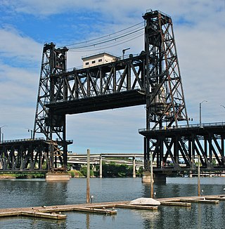
The Steel Bridge is a through truss, double-deck vertical-lift bridge across the Willamette River in Portland, Oregon, United States, opened in 1912. Its lower deck carries railroad and bicycle/pedestrian traffic, while the upper deck carries road traffic, and light rail (MAX), making the bridge one of the most multimodal in the world. It is the only double-deck bridge with independent lifts in the world and the second oldest vertical-lift bridge in North America, after the nearby Hawthorne Bridge. The bridge links the Rose Quarter and Lloyd District in the east to Old Town Chinatown neighborhood in the west.
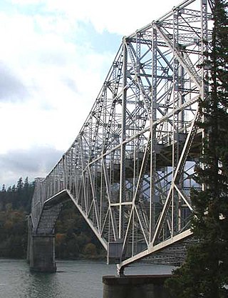
The Bridge of the Gods is a steel truss cantilever bridge that spans the Columbia River between Cascade Locks, Oregon, and Washington state near North Bonneville. It is approximately 40 miles (64 km) east of Portland, Oregon, and 4 miles (6.4 km) upriver from Bonneville Dam. It is a toll bridge operated by the Port of Cascade Locks.
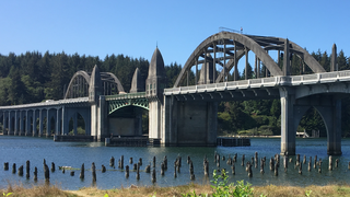
The Siuslaw River Bridge is a bascule bridge that spans the Siuslaw River on U.S. Route 101 in Florence, Oregon. It was designed by Conde McCullough, built by the Mercer-Fraser Company of Eureka, California, and funded by the Federal Emergency Administration of Public Works. It opened in 1936.

The Dent Bridge is a suspension bridge in the northwest United States, located in north central Idaho in Clearwater County, north of Orofino. It is 17 miles (27 km) up the North Fork of the Clearwater River, now Dworshak Reservoir. Completed 53 years ago in 1971 at a cost of $7,848,950, it has a main span of 1,050 feet (320 m), and an overall length of 1,550 feet (472 m).

The Isaac Lee Patterson Bridge, also known as the Rogue River Bridge and the Isaac Lee Patterson Memorial Bridge, is a concrete arch bridge that spans the Rogue River in Curry County, Oregon. The bridge was constructed by the Mercer Fraser Company of Eureka, California. The bridge carries U.S. Route 101 across the river, near the point where the river empties into the Pacific Ocean, and connects the towns of Gold Beach and Wedderburn. A bridge with strong Art Deco influences, the Isaac Lee Patterson Bridge is a prominent example of the designs of the Oregon bridge designer and highway engineer Conde McCullough. It was designated a National Historic Civil Engineering Landmark by the American Society of Civil Engineers in 1982. It is part of a series of notable bridges designed by McCullough for the Oregon Coast Highway in the 1930s. It was placed on the National Register of Historic Places in 2005.
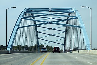
The Amelia Earhart Memorial Bridge is a network tied arch bridge over the Missouri River on U.S. Route 59 between Atchison, Kansas and Buchanan County, Missouri. It opened in December 2012, replacing a previous truss bridge with the same name.
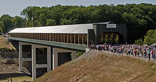
The Smolen–Gulf Bridge is a covered bridge which carries State Road across the Ashtabula River at the Plymouth and Ashtabula Township line in northern Ashtabula County, Ohio, United States. At 613 feet (187 m), it is the longest covered bridge in the United States – a title formerly held by the Cornish–Windsor Covered Bridge in New Hampshire and Vermont – and the fourth longest covered bridge in the world. The bridge, one of 17 drivable covered bridges in the county, was designed by John Smolen, former Ashtabula County Engineer when the idea of bridging the Ashtabula River Gulf with a wooden structure was first conceived in 1995.

The Hampden County Memorial Bridge is a reinforced-concrete arch bridge that spans the Connecticut River between Springfield, Massachusetts and West Springfield, Massachusetts, constructed in 1922. The bridge is owned by Massachusetts Highway Department and is located on Massachusetts Route 147. It spans 209 feet (64 m) and rises 29.71 feet (9.06 m) above the river.

The Wapato Bridge, formerly known as the Sauvie Island Bridge, crosses the Multnomah Channel of the Willamette River near Portland, Oregon, United States. The original Parker truss bridge, built in 1950 with a 200-foot (61 m) main span, was replaced with a tied arch bridge with a 360-foot (110 m) span in 2008 due to cracks discovered in 2001.

The Fred G. Redmon Bridge, also known as the Selah Creek Bridge, is a twin arch bridge in the northwest United States, in Yakima County, Washington. It carries Interstate 82 across Selah Creek near Selah, between Yakima and Ellensburg.

The Bellows Falls Arch Bridge was a three-hinged steel through arch bridge over the Connecticut River between Bellows Falls, Vermont and North Walpole, New Hampshire. It was structurally significant as the longest arch bridge in the United States when it was completed in 1905.

The Hadley Parabolic Bridge, often referred to locally as the Hadley Bow Bridge, carries Corinth Road across the Sacandaga River in Hadley, New York, United States. It is an iron bridge dating from the late 19th century.

The Mill Street Stone Arch Bridge is located on that street in Pine Hill, New York, United States. It is a small bridge over a local creek built around the turn of the 20th century. It is one of two stone arch bridges in the former village built by local stonemason Matthew G. Thompson. It has remained intact and in use since then, and was listed on the National Register of Historic Places in 1996. It is located in the Pine Hill Historic District.

The Parvin Bridge is a covered bridge located in Lane County, Oregon, U.S. near Dexter. It was built in 1921 as a single-lane 75-foot (23 m) bridge across Lost Creek, a tributary of the Middle Fork Willamette River.
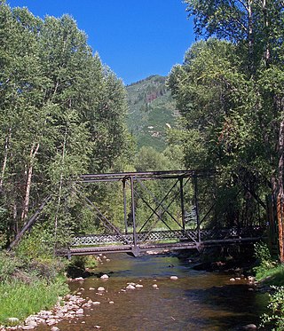
The Sheely Bridge, originally known as the Carbondale Bridge, carries pedestrian traffic across the Roaring Fork River at Mill Street Park in Aspen, Colorado, United States. It is a short steel truss bridge originally located downstream in Carbondale and later moved to its present location.

The Cheshire Bridge spans the Connecticut River between Charlestown, New Hampshire and Springfield, Vermont.

Heizer, also called Heizerton, is an unincorporated community in Barton County, Kansas, United States.

The Wells River Bridge between Wells River, Vermont and Woodsville, New Hampshire, is a steel double-decked Baltimore truss bridge over the Connecticut River. It was built in 1903 to carry rail and road traffic.

The Riverview Covered Pedestrian Bridge is a wooden Pratt truss covered bridge built beneath the Smolen-Gulf Bridge, completed in 2016. The new pedestrian covered bridge is 150 feet (46 m) long and 14 feet (4.3 m) wide. It is a Pratt truss design, like the Smolen-Gulf Bridge, and was designed by Smolen Engineering. It sits below Smolen Bridge in Indian Trails Park. It was dedicated on October 4, 2016.

The Maple Street Bridge is a girder bridge in the northwest United States in Spokane, Washington. It spans West Central to Downtown, crossing over the Spokane River and the Peaceful Valley neighborhood. Along with the Division Street Bridge and Monroe Street Bridge, the Maple Street Bridge is one of several major bridges that cross the Spokane River.


