Chandler's Purchase is a township located in Coös County, New Hampshire, United States. The purchase lies entirely within the White Mountain National Forest. As of the 2020 census, the purchase had a population of zero. It is the smallest township by area in Coos County.

Pinkham's Grant is a township in Coös County, New Hampshire, United States. The grant lies entirely within the White Mountain National Forest. As of the 2020 United States census, the population of the grant was zero.
Thompson and Meserve's Purchase is a township in Coös County, New Hampshire, United States. The purchase lies entirely within the White Mountain National Forest. As of the 2020 census, the population of the purchase was one.

Mount Jefferson is located in Coos County, New Hampshire, and is the third highest mountain in the state. The mountain is named after Thomas Jefferson, the third president of the United States, and is part of the Presidential Range of the White Mountains. Mount Jefferson is flanked by Mount Adams and Mount Clay.

The White Mountains Region is a tourism region designated by the New Hampshire Division of Travel and Tourism. It is located in northern New Hampshire in the United States and is named for the White Mountains, which cover most of the region. The southern boundary of the region begins at Piermont on the west, and runs east to Campton, then on to Conway and the Maine border. The northern boundary begins at Littleton and runs east to Gorham and the Maine border. The region to the north is known as the Great North Woods Region, which should not be confused with the larger and more general Great North Woods.
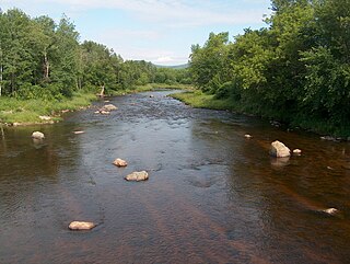
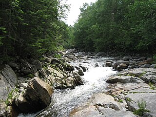
The Israel River, sometimes referred to as Israel's River, is a 23.2-mile-long (37.3 km) river in the White Mountains of New Hampshire, in the United States. It rises in the township of Low and Burbank's Grant and runs generally northwest along U.S. Route 2, traversing the towns of Jefferson and Lancaster, before joining the Connecticut River.

Franconia Notch is a major mountain pass through the White Mountains of New Hampshire. Dominated by Cannon Mountain to the west and Mount Lafayette to the east, it lies principally within Franconia Notch State Park and is traversed by the Franconia Notch Parkway. The parkway required a special act of Congress to sidestep design standards for the Interstate highway system because it is only one lane in each direction.

Mount Monroe is a 5,372-foot-high (1,637 m) mountain peak southwest of Mount Washington in the Presidential Range of the White Mountains in New Hampshire, United States. It is named for American President James Monroe and is the fourth highest mountain on the 4000 footers list for New Hampshire. The Appalachian Trail skirts its summit, which is the next highest peak on or near the trail north of Mount Rogers in Virginia. The Lakes of the Clouds, and its AMC hut, lie nestled at the col between Mount Monroe and neighboring Mount Washington.

Kilkenny is a township in Coös County, New Hampshire, United States. It lies entirely within the White Mountain National Forest. As of the 2020 census, the township had a population of zero.
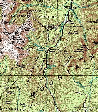
Pinkham Notch is a mountain pass in the White Mountains of north-central New Hampshire, United States. The notch is a result of extensive erosion by the Laurentide Ice Sheet during the Wisconsinian ice age. Pinkham Notch was eroded into a glacial U-shaped valley whose walls are formed by the Presidential, Wildcat, and Carter-Moriah ranges. Due to the volatility of the area's climate and rugged character of the terrain, a number of rare or endemic ecosystems have developed throughout the notch.
Mount Cabot is a mountain located in Coos County, in the U.S. state of New Hampshire. The mountain is the highest peak of the Pilot Range of the White Mountains. Cabot is flanked to the northeast by The Bulge, and to the south of Bunnell Notch by Terrace Mountain. Mount Cabot was named in honor of the Italian explorer Sebastian Cabot.
The West Branch of the Peabody River is a 5.8-mile-long (9.3 km) river in the White Mountains of New Hampshire in the United States. It is a tributary of the Peabody River, which flows into the Androscoggin River, which in turn flows east and south into Maine, joining the Kennebec River near the Atlantic Ocean. The West Branch of the Peabody is within the Great Gulf Wilderness of the White Mountain National Forest for most of its length. It is paralleled by the Great Gulf Trail, a popular route for backpackers.

Kinsman Mountain is a mountain located in Grafton County, New Hampshire. It is named after Nathan Kinsman, an early resident of Easton, New Hampshire, and is part of the Kinsman Range of the White Mountains. To the northeast, Kinsman is connected by The Cannon Balls ridge to Cannon Mountain.

The Pemigewasset Wilderness is a 45,000-acre (182 km2) federally designated Wilderness Area in the heart of New Hampshire's White Mountains. It is a part of the White Mountain National Forest. It is New Hampshire's largest wilderness area.
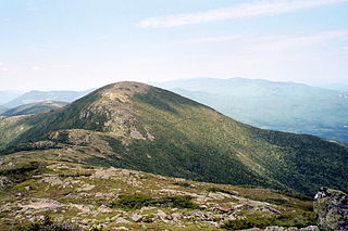
Mount Nancy, formerly Mount Amorisgelu, is a mountain located in Grafton County, New Hampshire, on the eastern boundary of the Pemigewasset Wilderness of the White Mountains. The mountain is the highest point and namesake of the Nancy Range. Mt. Nancy is flanked to the northeast by Mount Bemis, to the southwest by Mount Anderson, and to the southeast by Duck Pond Mountain. Although Mount Nancy is officially trailless, a visible path climbs to the summit from Norcross Pond. With a summit elevation of 3,926 feet (1,197 m), it is one of the New England Hundred Highest peaks.

The Cannon Balls is a mountain ridge located in Grafton County, New Hampshire. It is part of the Kinsman Range of the White Mountains. The ridge has three peaks with elevations of, from west to east, 3,693, 3,660, and 3,769 feet. The ridge takes its name from adjacent Cannon Mountain, on which a series of boulders, when viewed from the foot of the mountain, resemble an antique artillery cannon. The Cannon Balls are flanked to the northeast by Cannon Mountain, and to the southwest by Kinsman Mountain.

The Mountain Division is a railroad line that was once owned and operated by the Maine Central Railroad (MEC). It stretches from Portland, Maine on the Atlantic Ocean, through the Western Maine Mountains and White Mountains of New Hampshire, ending at St. Johnsbury, Vermont in the Northeast Kingdom. The line was abandoned in 1983 by MEC's successor, Guilford Transportation Industries (GTI). Guilford retained a stub between Portland and Westbrook. A section in New Hampshire remains in use by heritage railway Conway Scenic Railroad.

The Dartmouth Range is a mountain range in the White Mountains of New Hampshire in the United States. The range lies in the township of Low and Burbank's Grant and the town of Carroll in Coos County.
The Twin Range is a mountain range within the White Mountains of New Hampshire.

The Kinsman Range, also known as the Cannon–Kinsman Range, is a north–south range in the White Mountains of New Hampshire in the United States. Its highest point is 4,358-foot-high (1,328 m) Kinsman Mountain, followed by the 4,293-foot (1,309 m) North Peak of Kinsman, and 4,080-foot (1,240 m) Cannon Mountain, one of the richest in rock climbing routes in the Whites. All are official "Four-thousand footers". 3,478-foot (1,060 m) Mount Wolf is on the crest of the range south of Kinsman Mountain. Rounding out the range are 2,470-foot (750 m) Bald Peak on the west side of Kinsman Mountain and 2,530-foot (770 m) Mount Pemigewasset on the east side, overlooking Franconia Notch.

