Pennichuck Brook

Last updated
Pennichuck Brook

Nashua , NH WP 20180612 018.jpg

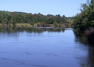
Supply Pond, part of Pennichuck Brook before the Pennichuck Water Co. dam, near the mouth of the brook at the Merrimack River
Country US
Physical characteristics
Main source Silver Lake (Hollis, New Hampshire)
102 feet (31 m) at Hollis, New Hampshire
River mouth Merrimack River

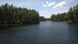
Pennichuck Brook is one of the tributaries of the Merrimack River in New Hampshire in the United States. Its watershed is 31 square miles (80 km2) and is one of the 14 subwatersheds of the Merrimack River. It passes through Nashua and Merrimack, New Hampshire and serves as the public water supply for greater Nashua. [1]

Merrimack River river in New Hampshire and Massachusetts, United States

The Merrimack River is a 117-mile-long (188 km) river in the northeastern United States. It rises at the confluence of the Pemigewasset and Winnipesaukee rivers in Franklin, New Hampshire, flows southward into Massachusetts, and then flows northeast until it empties into the Gulf of Maine at Newburyport. From Pawtucket Falls in Lowell, Massachusetts, onward, the Massachusetts–New Hampshire border is roughly calculated as the line three miles north of the river.

New Hampshire State of the United States of America

New Hampshire is a state in the New England region of the northeastern United States. It is bordered by Massachusetts to the south, Vermont to the west, Maine and the Atlantic Ocean to the east, and the Canadian province of Quebec to the north. New Hampshire is the 5th smallest by area and the 10th least populous of the 50 states. Concord is the state capital, while Manchester is the largest city in the state. It has no general sales tax, nor is personal income taxed at either the state or local level. The New Hampshire primary is the first primary in the U.S. presidential election cycle. Its license plates carry the state motto, "Live Free or Die". The state's nickname, "The Granite State", refers to its extensive granite formations and quarries.

United States Federal republic in North America

The United States of America (USA), commonly known as the United States or America, is a country comprising 50 states, a federal district, five major self-governing territories, and various possessions. At 3.8 million square miles, the United States is the world's third or fourth largest country by total area and is slightly smaller than the entire continent of Europe's 3.9 million square miles. With a population of over 327 million people, the U.S. is the third most populous country. The capital is Washington, D.C., and the largest city by population is New York City. Forty-eight states and the capital's federal district are contiguous in North America between Canada and Mexico. The State of Alaska is in the northwest corner of North America, bordered by Canada to the east and across the Bering Strait from Russia to the west. The State of Hawaii is an archipelago in the mid-Pacific Ocean. The U.S. territories are scattered about the Pacific Ocean and the Caribbean Sea, stretching across nine official time zones. The extremely diverse geography, climate, and wildlife of the United States make it one of the world's 17 megadiverse countries.

Contents

Route description

Pennichuck Brook begins at Silver Lake in Hollis. It flows northeast under NH 122 and into Dunklee Pond, then continues northeast into Pennichuck Pond, on the boundary between Hollis and Nashua. Leaving Pennichuck Pond, it becomes the boundary between Nashua and the town of Merrimack, flowing northeast under Amherst Street (NH 101A), then turning east and flowing into Holts Pond and Bowers Pond. While part of Bowers Pond, it is crossed by the Everett Turnpike. Past the outlet of Bowers Pond, the brook drops into Harris Pond and Supply Pond, then goes under the Daniel Webster Highway (U.S. Route 3) before it flows into the Merrimack River. All of these water bodies are dammed. The brook runs roughly parallel to the Nashua River from Pennichuck Pond to the brook's mouth in Nashua.

Silver Lake (Hollis, New Hampshire) lake of the United States of America

Silver Lake, formerly known as Long Pond, is a small lake in the town of Hollis, New Hampshire, United States. The lake was formerly surrounded by summer vacation cottages and camps, but most of these buildings have now been converted for use as year-round homes. Silver Lake State Park occupies the northern end of the lakeshore.

Hollis, New Hampshire Town in New Hampshire, United States

Hollis is a town in Hillsborough County, New Hampshire, United States. The population was 7,684 at the 2010 census. The town center village is listed on the National Register of Historic Places as Hollis Village Historic District.

New Hampshire Route 122 highway in New Hampshire

New Hampshire Route 122 is a 12.614-mile-long (20.300 km) north–south highway in Hillsborough County in southeastern New Hampshire, United States. The highway runs from Amherst south to Hollis on the Massachusetts border.

See also

Related Research Articles

Nashua, New Hampshire City in New Hampshire, United States

Nashua is a city in Hillsborough County, New Hampshire, United States. As of the 2010 census, Nashua had a population of 86,494, making it the second-largest city in the state after Manchester. As of 2017 the population had risen to an estimated 88,341.

Pelham, New Hampshire Town in New Hampshire, United States

Pelham is a town in Hillsborough County, New Hampshire, United States. The population was 12,897 at the 2010 census, and in 2017 the estimated population was 13,681.

Souhegan River river in the United States of America

The Souhegan River is a tributary of the Merrimack River in the northeastern United States. It is 33.8 miles (54.4 km) long with a drainage area of 171 sq mi (440 km2) and flows north and east through southern New Hampshire to the Merrimack River.

Nashua River river in the United States of America

The Nashua River, 37.5 miles (60.4 km) long, is a tributary of the Merrimack River in Massachusetts and New Hampshire in the United States. It is formed in eastern Worcester County, Massachusetts, by junction of its north and south branches near Lancaster, and flows generally north-northeast past Groton to join the Merrimack at Nashua, New Hampshire. The Nashua River Watershed occupies a major portion of north-central Massachusetts and a much smaller portion of southern New Hampshire.

New Hampshire Route 111 highway in New Hampshire

New Hampshire Route 111 is a 50.027-mile-long (80.511 km) east–west highway in Hillsborough and Rockingham counties in southeastern New Hampshire. The road runs from the Massachusetts border at Hollis to North Hampton on the Atlantic shore.

Dunstable, New Hampshire

Dunstable, New Hampshire was a town located in Hillsborough County, New Hampshire. It has been divided into several current cities and towns, including Nashua, Hollis, Hudson, Litchfield, and Merrimack.

Nissitissit River river in the United States of America

The Nissitissit River is a 10.5-mile-long (16.9 km) river located in southern New Hampshire and northern Massachusetts in the United States. It is a tributary of the Nashua River, itself a tributary of the Merrimack River, which flows to the Gulf of Maine. This river is part of the Nashua River Watershed.

Nubanusit Brook

Nubanusit Brook is a 14.3-mile-long (23.0 km) stream located in southern New Hampshire in the United States. It is a tributary of the Contoocook River, part of the Merrimack River watershed.

Cohas Brook is a 16.5-mile-long (26.6 km) river located in southern New Hampshire in the United States. It is a tributary of the Merrimack River, part of the Gulf of Maine watershed.

Beaver Brook is a 30.7-mile-long (49.4 km) river located in New Hampshire and Massachusetts in the United States. It is a tributary of the Merrimack River, part of the Gulf of Maine watershed.

Pequawket Brook is a 6.4-mile-long (10.3 km) stream near the White Mountains of New Hampshire in the United States. It lies within the watershed of the Saco River, which flows to the Atlantic Ocean in Maine. The brook is under the jurisdiction of the New Hampshire Comprehensive Shoreland Protection Act.

Circumferential Highway (Nashua)

The Circumferential Highway is the common name for a bypass route around the city of Nashua in southern New Hampshire, most of which has not yet been built. The purpose of the highway is to provide easier access to the F.E. Everett Turnpike and U.S. Route 3 in Nashua. Most of the highway will be built in Hudson, with small sections also built through the towns of Litchfield and Merrimack as well as the city of Nashua.

The North Fork of the East Branch of the Pemigewasset River is a 6.9-mile-long (11.1 km) river located in the White Mountains of New Hampshire in the United States. It is a tributary of the East Branch of the Pemigewasset River, part of the Merrimack River watershed.

The South Branch of the Souhegan River is a 5.8-mile-long (9.3 km) river located in northern Massachusetts and southern New Hampshire in the United States. It is a tributary of the Souhegan River, which flows to the Merrimack River and ultimately to the Gulf of Maine.

Squannacook River river in the United States of America

The Squannacook River is a 16.4-mile-long (26.4 km) river in northern Massachusetts. It is a tributary of the Nashua River and part of the Merrimack River watershed flowing to the Atlantic Ocean.

Salmon Brook (Merrimack River tributary) river in the United States of America

Salmon Brook is one of the 6 major tributaries of the Merrimack River in northeastern Massachusetts in the United States. Its watershed is 31 square miles (80 km2) and is one of the 14 subwatersheds of the Merrimack River. It passes through Groton, Dunstable, and Tyngsborough, Massachusetts, and then through Nashua, New Hampshire.

Greeley Park

Greeley Park is a public park in Nashua, New Hampshire, United States, occupying 125 acres (51 ha) extending from the Merrimack River, across Concord Street, to Manchester Street. The property was originally bought in 1801 by Joseph Greeley, who passed it on to his son after his death. The land was deeded to the city of Nashua in 1896 by Joseph Thornton Greeley, the grandson of the original Joseph Greeley. In 1908, John E. Cotton donated $5000, an amount that was "matched by city funds", to change the Greeley Farm into a public park. The money was used to create a "stone and cement rest house, a fountain, a shallow pond, a gravel walk, and flower beds".

Potanipo Pond

Potanipo Pond is a 136-acre (55 ha) water body located in Hillsborough County in southern New Hampshire, United States, in the town of Brookline. Potanipo Pond is the source of the Nissitissit River, which flows via the Nashua River into the Merrimack River, and then to the Gulf of Maine.

References

  1. Where Does Your Drinking Water Come From?, Pennichuck Corporation; accessed September 20, 2012

Coordinates: 42°48′00″N71°28′08″W / 42.80000°N 71.46889°W / 42.80000; -71.46889

Geographic coordinate system Coordinate system

A geographic coordinate system is a coordinate system that enables every location on Earth to be specified by a set of numbers, letters or symbols. The coordinates are often chosen such that one of the numbers represents a vertical position and two or three of the numbers represent a horizontal position; alternatively, a geographic position may be expressed in a combined three-dimensional Cartesian vector. A common choice of coordinates is latitude, longitude and elevation. To specify a location on a plane requires a map projection.