Wakefield is a town in Carroll County, New Hampshire, United States. The population was 5,201 at the 2020 census. The town includes the villages of Wakefield Corner, East Wakefield, North Wakefield, Sanbornville, Union, Woodman and Province Lake. Wakefield Corner, popular with tourists, is a picturesque hilltop village of antique buildings. The state of Maine forms the eastern border of Wakefield.

Rindge is a town in Cheshire County, New Hampshire, United States. The population was 6,476 at the 2020 census, up from 6,014 at the 2010 census. Rindge is home to Franklin Pierce University, the Cathedral of the Pines and part of Annett State Forest.

Groton is a town in Grafton County, New Hampshire, United States. The population was 569 at the 2020 census.
Deering is a town in Hillsborough County, New Hampshire, United States. The population was 1,904 at the 2020 census.

Greenfield is a town in Hillsborough County, New Hampshire, United States. The population was 1,716 at the 2020 census. Greenfield is home to the Crotched Mountain Rehabilitation Center, to Greenfield State Park, and to part of the Wapack Trail.

Sharon is a town in Hillsborough County, New Hampshire, United States. The population was 359 at the 2020 census. It was the long-time home to the Sharon Arts Center, a nonprofit which has ceased operations.
Boscawen is a town in Merrimack County, New Hampshire, United States. The population was 3,998 at the 2020 census.

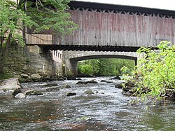
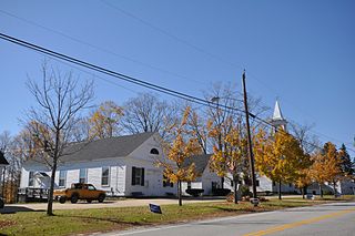
Contoocook is a village and census-designated place (CDP) within the town of Hopkinton in Merrimack County, New Hampshire, United States. The population was 1,427 at the 2020 census. Contoocook is well known for its growth of small businesses, preservation of historical landmarks, community involvement and recreational activities within the village.
Danbury is a town in Merrimack County, New Hampshire, United States. The population was 1,250 at the 2020 census.
Salisbury is a town in Merrimack County, New Hampshire, United States. The population was 1,422 at the 2020 census.

Sutton is a town in Merrimack County, New Hampshire, United States. The population was 1,978 at the 2020 census. Sutton includes the villages of Sutton Mills, North Sutton, South Sutton and East Sutton. North Sutton is home to Wadleigh State Park on Kezar Lake.
Warner is a town in Merrimack County, New Hampshire, United States. The population was 2,937 at the 2020 census. The town is home to Rollins State Park and Mount Kearsarge State Forest.

Jaffrey is a town in Cheshire County, New Hampshire, United States. The population was 5,320 at the 2020 census.
Antrim is a town in Hillsborough County, New Hampshire, United States. The population was 2,651 at the 2020 census. The main village in the town, where 1,395 people lived at the 2020 census, is defined as the Antrim census-designated place (CDP) and is located at the intersection of U.S. Route 202 and New Hampshire Route 31. The town of Antrim also includes the villages of Antrim Center, North Branch, and Clinton Village.
Henniker is a town in Merrimack County, New Hampshire, United States. As of the 2020 census, the reported total population of the town was 6,185, although the figure, 27.9% greater than the 2010 population, has been questioned by local officials. Henniker is home to New England College and Pats Peak Ski Area. Henniker is a college town and resort area, featuring both skiing and white-water kayaking.

Peterborough is a town in Hillsborough County, New Hampshire, United States. The population was 6,418 at the 2020 census. The main village, with 3,090 people at the 2020 census, is a census-designated place (CDP) and lies along the Contoocook River at the junction of U.S. Route 202 and New Hampshire Route 101. Peterborough is 38 miles (61 km) west of Manchester and 72 miles (116 km) northwest of Boston.

Nubanusit Brook is a 14.3-mile-long (23.0 km) stream in southern New Hampshire in the United States. The brook begins at the outlet of Nubanusit Lake in Nelson. It is a tributary of the Contoocook River, part of the Merrimack River watershed. The brook flows south into Harrisville, interrupted by Harrisville Pond and Skatutakee Lake, then east to the MacDowell Reservoir in Peterborough. The brook turns south, passes the village of West Peterborough, and reaches the Contoocook River after passing through Peterborough village.

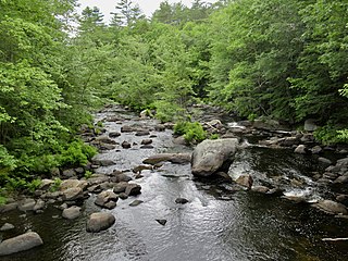
The North Branch of the Contoocook River is a 16.8-mile-long (27.0 km) river in southwestern New Hampshire in the United States. It is a tributary of the Contoocook River, part of the Merrimack River watershed.

The Warner River is a 20.3-mile-long (32.7 km) river located in central New Hampshire in the United States. It is a tributary of the Contoocook River, part of the Merrimack River watershed.
The Blackwater River is a 37.5-mile-long (60.4 km) river located in central New Hampshire in the United States. It is a tributary of the Contoocook River, part of the Merrimack River watershed.