Hopkinton, New Hampshire

Last updated

Hopkinton, New Hampshire
Hopkinton NH Town Hall.jpg
Town hall
Hopkinton Town Seal.png
Merrimack County New Hampshire incorporated and unincorporated areas Hopkinton highlighted.svg
Location in Merrimack County and the state of New Hampshire.
Coordinates: 43°11′29″N71°40′31″W / 43.19139°N 71.67528°W / 43.19139; -71.67528
CountryUnited States
State New Hampshire
County Merrimack
Granted 1735
Settled 1736
Incorporated January 10, 1765
Villages
Government
   Select Board
  • Sabrina Dunlap, Chair
  • Ken Traum
  • Jeffrey Donohoe
  • Steven Whitley
  • Thomas Lipoma
   Town Administrator Neal Cass
Area
[1]
  Total45.09 sq mi (116.77 km2)
  Land43.30 sq mi (112.14 km2)
  Water1.79 sq mi (4.63 km2)  3.97%
Elevation
505 ft (154 m)
Population
 (2020) [2]
  Total5,914
  Density136/sq mi (52.7/km2)
Time zone UTC−5 (Eastern)
  Summer (DST) UTC−4 (Eastern)
ZIP code
03229
Area code 603
FIPS code 33-37540
GNIS feature ID0873630
Website www.hopkinton-nh.gov

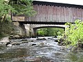
Hopkinton is a town in Merrimack County, New Hampshire, United States. The population was 5,914 at the 2020 census. [2] The town has three distinct communities: Hopkinton village, mainly a residential area in the center of the town; Contoocook, the town's business hub, located in the north; and West Hopkinton, within the more agricultural portion of the town. The town is home to the Hopkinton State Fair, adjacent to Contoocook village, and to the historic Contoocook Railroad Depot and the Contoocook Railroad Bridge, the oldest covered railroad bridge in the United States. [3]

Contents

History

The town's first framed house built in 1745, as seen in 1901 James Story House, Hopkinton, NH.jpg
The town's first framed house built in 1745, as seen in 1901

The town was granted by colonial Governor Jonathan Belcher in 1735 as "Number 5" to settlers from Hopkinton, Massachusetts, who renamed it "New Hopkinton". First settled in 1736, colonists were required to build homes, fence in their land, plant it with English grass, and provide a home for a minister, all within seven years. The community was incorporated in 1765 by Governor Benning Wentworth, [4] predating the establishment of counties in the colonial province. Built in 1789, the Congregational Church has a Revere bell. [5] The state legislature met in Hopkinton occasionally between 1798 and 1807. In 1808, the town competed for the coveted position of state capital, but was defeated by neighboring Concord. Since 1823, the town has been within Merrimack County.

W. S. Davis Building 1889 Life and times in Hopkinton, N.H (1890) (14590292740).jpg
W. S. Davis Building 1889

A substantial portion of the town in the north was named "Contoocook Village", for a tribe of the Pennacook people who once lived there. Due to its position along the Contoocook River, it became a center for water-powered industry, particularly lumber and textiles. The Contoocook covered railroad bridge in the village is a remnant of the Boston & Maine Railroad and is the oldest covered bridge of its kind still standing in the United States. [3] Next to the bridge is the Contoocook Railroad Depot, one of the original railroad depots for the Concord and Claremont Railroad.

Since 1915, Hopkinton has been home to the Hopkinton State Fair, an event which attracts thousands of visitors each year during the Labor Day weekend. [6]

Geography

According to the United States Census Bureau, the town has a total area of 45.1 square miles (116.8 km2), of which 43.3 square miles (112.1 km2) are land and 1.8 square miles (4.6 km2) are water, comprising 3.97% of the town. [1] Hopkinton is drained by the Contoocook River and its tributary, the Warner River, except for the southeast part of town, which drains to the Turkey River. The highest point in town is Shaker Hill, on the border with Henniker, with an elevation of 923 feet (281 m) above sea level. Hopkinton lies fully within the Merrimack River watershed. [7]

Adjacent municipalities

Demographics

Historical population
CensusPop.Note
1790 1,715
1800 2,01517.5%
1810 2,21610.0%
1820 2,43710.0%
1830 2,4741.5%
1840 2,454−0.8%
1850 2,169−11.6%
1860 2,1780.4%
1870 1,814−16.7%
1880 1,8361.2%
1890 1,817−1.0%
1900 1,652−9.1%
1910 1,578−4.5%
1920 1,438−8.9%
1930 1,4853.3%
1940 1,5876.9%
1950 1,83115.4%
1960 2,22521.5%
1970 3,00735.1%
1980 3,86128.4%
1990 4,80624.5%
2000 5,39912.3%
2010 5,5893.5%
2020 5,9145.8%
U.S. Decennial Census [2] [8]
Oldest part of Hopkinton village cemetery, as seen in 1901 Old Cemetery, Hopkinton, NH.jpg
Oldest part of Hopkinton village cemetery, as seen in 1901

As of the census [9] of 2010, there were 5,589 people, 2,204 households, and 1,631 families residing in the town. The population density was 124.7 inhabitants per square mile (48.1/km2). The racial makeup of the town was 97.7% White, 0.3% African American, 0.1% Native American, 0.6% Asian, 0.07% Pacific Islander, 0.1% from other races, and 1.2% from two or more races. Hispanic or Latino of any race were 1% of the population.

There were 2,204 households, out of which 32.8% had children under the age of 18 living with them, 63.1% were married couples living together, 7% had a female householder with no husband present, and 26% were non-families. 19.6% of all households were made up of individuals living alone, and 6.3% had someone living alone who was 65 years of age or older. The average household size was 2.54 and the average family size was 2.92.

Old Parsonage in 1901 Old Parsonage, Hopkinton, NH.jpg
Old Parsonage in 1901

In the town, the population was spread out, with 25.3% under the age of 20, 3.3% from 20 to 24, 20.1% from 25 to 44, 35.2% from 45 to 64, and 16.2% who were 65 years of age or older. The median age was 45.8 years.

The median income for a household in the town was $84,911, and the median income for a family was $88,796. Males had a median income of $53,806 versus $45,656 for females. The per capita income for the town was $40,580. About 4.2% of the population was below the poverty line.

Government

In the New Hampshire Senate, Hopkinton is in the 15th District, represented by Democrat Becky Whitley. On the New Hampshire Executive Council, Hopkinton is in the 2nd District, represented by Democrat Cinde Warmington. In the United States House of Representatives, Hopkinton is in New Hampshire's 2nd congressional district, represented by Democrat Ann McLane Kuster.

Education

Public education is managed by the Hopkinton School District. Kindergarten through third-grade students attend Harold Martin School in Hopkinton village, and fourth through sixth graders attend Maple Street School in Contoocook village. The middle school is combined with Hopkinton High School in Contoocook village, which serves seventh through twelfth graders, and its sports teams are nicknamed the Hawks.

The town of Hopkinton also includes The Beech Hill School, an independent middle school serving grades 6th through 8th. [10]

Notable people

National Register of Historic Places

[11] Name on the Register [12] ImageDate listed [13] Location City or townDescription
1 Contoocook Railroad Depot
Contoocook Railroad Depot Contoocook Railroad Depot, Contoocook NH.jpg
Contoocook Railroad Depot
March 16, 2006
(#06000131)
896 Main St.
43°13′21″N71°42′47″W / 43.2225°N 71.7131°W / 43.2225; -71.7131 (Contoocook Railroad Depot)
Contoocook VillageOwned by the Contoocook Riverway Association
2 Hopkinton Railroad Covered Bridge
Hopkinton Railroad Covered Bridge Bridges over the Contoocook River in Contoocook, New Hampshire.jpg
Hopkinton Railroad Covered Bridge
January 11, 1980
(#80000294)
Off NH 103 and NH 127
43°13′23″N71°42′51″W / 43.2231°N 71.7142°W / 43.2231; -71.7142 (Hopkinton Railroad Covered Bridge)
Contoocook VillageOver Contoocook River in village of Contoocook
3 Howe-Quimby House
Howe-Quimby House HopkintonNH HoweQuimbyHouse.jpg
Howe-Quimby House
June 27, 1980
(#80000295)
862 Sugar Hill Rd.
43°09′29″N71°42′03″W / 43.1581°N 71.7008°W / 43.1581; -71.7008 (Howe-Quimby House)
Hopkinton
4 William H. Long Memorial
William H. Long Memorial HopkintonNH WilliamHLongMemorial.jpg
William H. Long Memorial
July 15, 1977
(#77000092)
300 Main St.
43°11′27″N71°40′19″W / 43.1908°N 71.6719°W / 43.1908; -71.6719 (William H. Long Memorial)
Hopkinton VillageNow houses the Hopkinton Historical Society.
5 Rowell's Covered Bridge
Rowell's Covered Bridge HopkintonNH RowellsBridge.jpg
Rowell's Covered Bridge
November 21, 1976
(#76000129)
Clement Hill Rd.
43°11′33″N71°44′54″W / 43.1925°N 71.7483°W / 43.1925; -71.7483 (Rowell's Covered Bridge)
West Hopkinton Over Contoocook River
6 Stanley Tavern
Stanley Tavern HopkintonNH StevensTavern.jpg
Stanley Tavern
September 7, 2005
(#05000970)
371 Main St.
43°11′29″N71°40′27″W / 43.1914°N 71.6742°W / 43.1914; -71.6742 (Stanley Tavern)
Hopkinton Village

Sites of interest

Related Research Articles

<span class="mw-page-title-main">Merrimack County, New Hampshire</span> County in New Hampshire, United States

Merrimack County is a county in the U.S. state of New Hampshire. As of the 2020 Census, the population was 153,808, making it the third most populous county in New Hampshire. Its county seat is Concord, the state capital. The county was organized in 1823 from parts of Hillsborough and Rockingham counties, and is named for the Merrimack River. Merrimack County comprises the Concord, NH Micropolitan Statistical Area, which in turn constitutes a portion of the Boston–Worcester–Providence, MA–RI–NH–CT Combined Statistical Area. In 2010, the center of population of New Hampshire was located in Merrimack County, in the town of Pembroke.

<span class="mw-page-title-main">Harrisville, New Hampshire</span> Town in New Hampshire, United States

Harrisville is a town in Cheshire County, New Hampshire, United States. Besides the town center, it also includes the villages of Chesham and Eastview. The population of the town was 984 at the 2020 census.

<span class="mw-page-title-main">Deering, New Hampshire</span> Town in New Hampshire, United States

Deering is a town in Hillsborough County, New Hampshire, United States. The population was 1,904 at the 2020 census.

<span class="mw-page-title-main">Weare, New Hampshire</span> Town in New Hampshire, United States

Weare is a town in Hillsborough County, New Hampshire, United States. The population was 9,092 at the 2020 census. It is close to two important New Hampshire cities, Manchester and Concord.

<span class="mw-page-title-main">Allenstown, New Hampshire</span> Town in New Hampshire, United States

Allenstown is a town in Merrimack County, New Hampshire, United States. The population was 4,707 at the 2020 census, up from 4,322 at the 2010 census. Allenstown includes a portion of the village of Suncook. Just over one-half of the town's area is covered by Bear Brook State Park.

<span class="mw-page-title-main">Andover, New Hampshire</span> Town in New Hampshire, United States

Andover is a town in Merrimack County, New Hampshire, United States. The population was 2,406 at the 2020 census. Andover includes the villages of Cilleyville, Potter Place, East Andover, and West Andover, in addition to the town center. The town is home to Ragged Mountain State Forest and Proctor Academy, a private coeducational preparatory school.

<span class="mw-page-title-main">Boscawen, New Hampshire</span> Town in New Hampshire, United States

Boscawen is a town in Merrimack County, New Hampshire, United States. The population was 3,998 at the 2020 census.

<span class="mw-page-title-main">Bow, New Hampshire</span> Town in New Hampshire, United States

Bow is a town in Merrimack County, New Hampshire, United States. The population was 8,229 at the 2020 census, up from 7,519 at the 2010 census, an increase of 9.4%.

<span class="mw-page-title-main">Bradford, New Hampshire</span> Town in New Hampshire, United States

Bradford is a town in Merrimack County, New Hampshire, United States. The population was 1,662 at the 2020 census. The main village of the town, where 372 people resided at the 2020 census, is defined as the Bradford census-designated place (CDP), and is located in the northeast part of the town, west of the junction of New Hampshire routes 103 and 114. The town also includes the village of Bradford Center.

<span class="mw-page-title-main">Contoocook, New Hampshire</span> Census-designated place in New Hampshire, United States

Contoocook is a village and census-designated place (CDP) within the town of Hopkinton in Merrimack County, New Hampshire, United States. The population was 1,427 at the 2020 census. Contoocook is well known for its growth of small businesses, preservation of historical landmarks, community involvement and recreational activities within the village.

<span class="mw-page-title-main">Franklin, New Hampshire</span> City in New Hampshire, United States

Franklin is a city in Merrimack County, New Hampshire, United States. At the 2020 census, the population was 8,741, the lowest figure of New Hampshire's 13 cities. Franklin includes the village of West Franklin.

<span class="mw-page-title-main">Warner, New Hampshire</span> Town in New Hampshire, United States

Warner is a town in Merrimack County, New Hampshire, United States. The population was 2,937 at the 2020 census. The town is home to Magdalen College of the Liberal Arts, Rollins State Park and Mount Kearsarge State Forest.

<span class="mw-page-title-main">Webster, New Hampshire</span> Town in New Hampshire, United States

Webster is a town in Merrimack County, New Hampshire, United States. The population was 1,913 at the 2020 census.

<span class="mw-page-title-main">Henniker (CDP), New Hampshire</span> Census-designated place in New Hampshire, United States

Henniker is a census-designated place (CDP) and the main village in the town of Henniker in Merrimack County, New Hampshire, United States. The population of the CDP was 3,166 at the 2020 census, out of 6,185 in the entire town. The CDP is the home to New England College.

<span class="mw-page-title-main">Henniker, New Hampshire</span> Town in New Hampshire, United States

Henniker is a town in Merrimack County, New Hampshire, United States. As of the 2020 census, the reported total population of the town was 6,185, although the figure, 27.9% greater than the 2010 population, has been questioned by local officials. Henniker is home to New England College and Pats Peak Ski Area. Henniker is a college town and resort area, featuring both skiing and white-water kayaking.

<span class="mw-page-title-main">Hillsborough, New Hampshire</span> Town in New Hampshire, United States

Hillsborough, frequently spelled Hillsboro, is a town in Hillsborough County, New Hampshire, United States. The population was 5,939 at the 2020 census. The town is home to Fox State Forest and part of Low State Forest.

<span class="mw-page-title-main">Contoocook River</span> River in New Hampshire, United States

The Contoocook River is a 71-mile-long (114 km) river in New Hampshire. It flows from Contoocook Lake on the Jaffrey/Rindge border to Penacook, where it empties into the Merrimack River. It is one of only a few rivers in New Hampshire that flow in a predominantly northward direction. Four covered bridges span the river, one in the town of Henniker, one on the Hancock-Greenfield line, and two in the town of Hopkinton, New Hampshire with one being in the village of Contoocook, and the other in the populated place of West Hopkinton. Residents and tourists have made the Contoocook popular for fishing and whitewater boating.

<span class="mw-page-title-main">West Hopkinton, New Hampshire</span> Populated place in New Hampshire, United States

West Hopkinton is a populated place within the town of Hopkinton in Merrimack County, New Hampshire, United States. West Hopkinton is well known for its agricultural center, preservation of historical landmarks and recreational activities within the village.

<span class="mw-page-title-main">Contoocook Railroad Bridge</span> United States historic place

The Contoocook Railroad Bridge is a covered bridge on the former Contoocook Valley Railroad line spanning the Contoocook River in the center of the village of Contoocook, New Hampshire, United States. It is referred to in the National Register of Historic Places as the Hopkinton Railroad Covered Bridge, for the town of Hopkinton, New Hampshire, in which the village of Contoocook is located.

<span class="mw-page-title-main">Contoocook Railroad Depot</span> United States historic place

The Contoocook Railroad Depot is located in Hopkinton, New Hampshire, United States, in the village of Contoocook. The depot was completed in 1849 as one of the first substantial railroad passenger stations west of Concord on the Concord and Claremont Railroad. The building is one of the best preserved of a small number of gable-roofed railroad stations surviving from the first decade of rail development in New Hampshire. The station exemplifies the pioneering period of rail development in the state.

References

  1. 1 2 "2021 U.S. Gazetteer Files – New Hampshire". United States Census Bureau. Retrieved December 15, 2021.
  2. 1 2 3 "Hopkinton town, Merrimack County, New Hampshire: 2020 DEC Redistricting Data (PL 94-171)". U.S. Census Bureau. Retrieved December 15, 2021.
  3. 1 2 "RAILROAD BRIDGE, Hopkinton, New Hampshire". New Hampshire Division of Historic Resources. Retrieved January 10, 2008.
  4. "History of Hopkinton". J. W. Lewis and Co. 1885.
  5. Chapter XXVII. Charles Chase Lord. 1890.
  6. "Hopkinton State Fair - History". Archived from the original on July 26, 2014. Retrieved May 30, 2014.
  7. Foster, Debra H.; Batorfalvy, Tatianna N.; Medalie, Laura (1995). Water Use in New Hampshire: An Activities Guide for Teachers. U.S. Department of the Interior and U.S. Geological Survey.
  8. "Census of Population and Housing". Census.gov. Retrieved June 4, 2016.
  9. "U.S. Census website". United States Census Bureau . Retrieved January 31, 2008.
  10. "The Beech Hill School". Thebeechhillschool.org. Retrieved January 31, 2022.
  11. Numbers represent an alphabetical ordering by significant words. Various colorings, defined here, differentiate National Historic Landmarks and historic districts from other NRHP buildings, structures, sites or objects.
  12. "National Register Information System". National Register of Historic Places . National Park Service. April 24, 2008.
  13. The eight-digit number below each date is the number assigned to each location in the National Register Information System database, which can be viewed by clicking the number.