
Essex County is a county in the northeastern part of the U.S. state of Massachusetts. As of the 2010 census, the total population was 743,159, making it the third-most populous county in the state. It is part of the Greater Boston area. The largest city in Essex County is Lynn. The county was named after the English county of Essex.

Merrimac is a small town in Essex County, Massachusetts, United States, and on the southeastern border of New Hampshire, approximately 34 miles (55 km) northeast of Boston and 10 miles (16 km) west of the Atlantic Ocean. It was incorporated on April 11, 1876. It is situated along the north bank of the Merrimack River in the Merrimack Valley. The population was 6,338 at the 2010 census. Historically a manufacturing center, it has long since become a largely residential community. It is part of the Greater Boston metropolitan area.

Newbury is a town in Essex County, Massachusetts, USA. The population was 6,666 at the 2010 census. Newbury includes the villages of Old Town, Plum Island and Byfield. Each village is a precinct with its own voting district, various town offices, and business center.
Francestown is a town in Hillsborough County, New Hampshire, United States. The population was 1,562 at the 2010 census.

Newbury is a market town in Berkshire, England, which is home to the administrative headquarters of West Berkshire.

Newport is a census-designated place (CDP) comprising the primary village and surrounding rural land in the town of Newport in Sullivan County, New Hampshire, United States. The population of the CDP was 4,769 at the 2010 census, out of 6,507 people in the entire town of Newport.

Newbury is a town in Orange County, Vermont, United States. The population was 2,216 at the 2010 census. Newbury includes the villages of Newbury, Center Newbury, West Newbury, South Newbury, Boltonville, Peach Four Corners, and Wells River. The town maintains a public website that is updated regularly.

U.S. Route 5 is a north–south United States highway running through the New England states of Connecticut, Massachusetts, and Vermont. Significant cities along the route include New Haven, Connecticut; Hartford, Connecticut; and Springfield, Massachusetts. From Hartford northward to St. Johnsbury, Vermont, the road closely follows the route of the Connecticut River.
U.S. Route 302 is an east–west spur of U.S. Route 2 in northern New England in the United States. It currently runs 171 miles (275 km) from Montpelier, Vermont, beginning at US 2, to Portland, Maine, at U.S. Route 1. It passes through the states of Vermont, New Hampshire and Maine.

New Hampshire Route 12 is a 62.773-mile (101.023 km) long north-south state highway in southwestern New Hampshire. Its southern terminus is at the Massachusetts state line in Fitzwilliam, where it continues south as Massachusetts Route 12. Its northern terminus is at the Vermont state line in Claremont, where it continues north as Vermont Route 12. Most of the northern part of NH 12 runs along the Connecticut River.

New Hampshire Route 103 is a 48.300-mile-long (77.731 km) east–west highway in west-central New Hampshire, United States. The highway runs from Claremont, at the Vermont border on the Connecticut River, to Hopkinton, west of Concord.

Byfield is a village in the town of Newbury, in Essex County, Massachusetts, United States. It borders West Newbury, Georgetown, and Rowley. It is located about 30 miles north-northeast of Boston, along Interstate 95, about 10 miles south of the border between New Hampshire and Massachusetts.

The Warner River is a 20.3-mile-long (32.7 km) river located in central New Hampshire in the United States. It is a tributary of the Contoocook River, part of the Merrimack River watershed.

The West Branch of the Warner River is a 6.5-mile-long (10.5 km) river located in central New Hampshire in the United States. It is a tributary of the Warner River, part of the Contoocook River watershed.

Lake Solitude is a highland tarn located in western New Hampshire, United States, at the top of Sunapee Ridge between the main summit of Mount Sunapee and South Peak. The lake, covering 6 acres (2.4 ha), is approximately 832 feet (254 m) long by 383 feet (117 m) wide and is located within Mount Sunapee State Park in the town of Newbury. A popular hiking destination, Lake Solitude is accessible via the Andrew Brook Trail, the Newbury Trail, or the long-distance Monadnock-Sunapee Greenway Trail. White Ledge, elevation 2,720 feet (830 m), rises steeply above the lake's west shore and provides expansive views. The lake is considered an important habitat for rare species and is off limits to swimmers and dogs.

Guild is an unincorporated community in the town of Newport in Sullivan County, New Hampshire, in the United States. It is located near the eastern boundary of Newport, along New Hampshire Routes 11 and 103. Route 11 proceeds east to Sunapee and New London, while Route 103 travels southeast to Newbury, Bradford, and Warner. Both routes travel west to the center of Newport and on to Claremont. The village is located along the Sugar River.
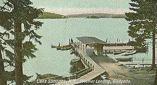
Blodgett Landing is a census-designated place in the town of Newbury in Merrimack County, New Hampshire. It had a population of 101 at the 2010 census.

Bradford is a census-designated place (CDP) and the main village in the town of Bradford in Merrimack County, New Hampshire, United States. The population of the CDP was 356 at the 2010 census, out of 1,650 in the entire town of Bradford.
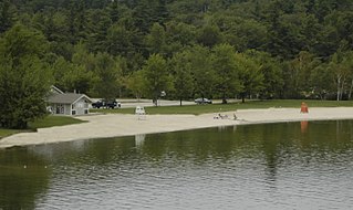
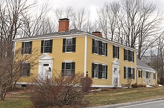
Mount Sunapee State Park is a state park in Newbury, New Hampshire. The park includes a beach portion on Lake Sunapee and most of Mount Sunapee. The state has leased the ski area to Mount Sunapee Resort.


