Blodgett Landing, New Hampshire

Last updated

Blodgett Landing, New Hampshire
Blodgett's Landing, Lake Sunapee.jpg
1905 postcard
Merrimack County New Hampshire incorporated and unincorporated areas Blodgett Landing highlighted.svg
Location in Merrimack County and the state of New Hampshire.
Coordinates: 43°22′25″N72°2′31″W / 43.37361°N 72.04194°W / 43.37361; -72.04194
Country United States
State New Hampshire
County Merrimack
Town Newbury
Area
[1]
  Total0.29 sq mi (0.75 km2)
  Land0.29 sq mi (0.75 km2)
  Water0.00 sq mi (0.00 km2)
Elevation
1,120 ft (340 m)
Population
 (2020)
  Total152
  Density522.34/sq mi (201.76/km2)
Time zone UTC-5 (Eastern (EST))
  Summer (DST) UTC-4 (EDT)
ZIP Code
03255 (Newbury)
Area code 603
FIPS code 33-06020
GNIS feature ID0871303

Blodgett Landing (frequently spelled Blodgetts Landing or Blodgett's Landing) is a census-designated place in the town of Newbury, Merrimack County, New Hampshire, United States. It had a population of 152 at the 2020 census, [2] up from 101 at the 2010 census. [3]

Contents

Geography

Blodgett Landing is located in the northern part of Newbury, between New Hampshire Route 103A and the shore of Lake Sunapee. [4] It is bordered to the north by the town of New London.

According to the U.S. Census Bureau, the Blodgett Landing CDP has a total area of 0.29 square miles (0.75 km2), all land. [5]

Demographics

Historical population
CensusPop.Note
2010 101
2020 15250.5%
U.S. Decennial Census [6]

As of the census of 2010, there were 101 people, 54 households, and 32 families residing in the CDP. There were 159 housing units, of which 105, or 66.0%, were vacant seasonal or vacation properties. The racial makeup of the CDP was 98.0% white, 1.0% Native American, and 1.0% "some other race". 2.0% of the population were Hispanic or Latino of any race. [7]

Of the 54 households in the CDP, 7.4% had children under the age of 18 living with them, 48.1% were headed by married couples living together, 5.6% had a female householder with no husband present, and 40.7% were non-families. 35.2% of all households were made up of individuals, and 9.3% were someone living alone who was 65 years of age or older. The average household size was 1.87, and the average family size was 2.38. [7]

6.9% of residents in the CDP were under the age of 18, 7.1% were from age 18 to 24, 11.0% were from 25 to 44, 47.5% were from 45 to 64, and 27.7% were 65 years of age or older. The median age was 57.3 years. For every 50 females there were 57.4 males. For every 50 females age 18 and over, there were 56.8 males. [7]

Related Research Articles

<span class="mw-page-title-main">New London, New Hampshire</span> Town in New Hampshire, United States

New London is a town in Merrimack County, New Hampshire, United States. The population was 4,400 at the 2020 census. The town is the home of Colby–Sawyer College, site of the Gordon Research Conferences since 1947.

<span class="mw-page-title-main">Newbury, New Hampshire</span> Town in New Hampshire, United States

Newbury is a town in Merrimack County, New Hampshire, United States. The population was 2,172 at the 2020 census. Newbury is home to part of Lake Sunapee, including Mount Sunapee State Park Beach. Mount Sunapee Resort, a ski area in Mount Sunapee State Park, is in the west. The town includes the villages of Newbury, Blodgett Landing and South Newbury.

<span class="mw-page-title-main">Sunapee, New Hampshire</span> Place in New Hampshire, United States

Sunapee is a town in Sullivan County, New Hampshire, United States. The population was 3,342 at the 2020 census. The town is home to part of Lake Sunapee and includes the village of Georges Mills.

<span class="mw-page-title-main">Tilton Northfield, New Hampshire</span> Census-designated place in New Hampshire, United States

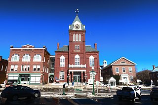
Tilton Northfield is a census-designated place (CDP) representing two adjacent villages in the towns of Tilton in Belknap County and Northfield in Merrimack County in the U.S. state of New Hampshire. The CDP encompasses the town centers of both Tilton and Northfield, located on either side of the Winnipesaukee River. The population was 3,324 at the 2020 census.

Gorham is a census-designated place (CDP) and the main village in the town of Gorham in Coos County, New Hampshire, United States. The population of the CDP was 1,851 at the 2020 census, out of 2,698 people in the entire town of Gorham.

<span class="mw-page-title-main">Greenville (CDP), New Hampshire</span> Census-designated place in New Hampshire, United States

Greenville is a census-designated place (CDP) and the main village in the town of Greenville in Hillsborough County, New Hampshire, United States. The population of the CDP was 1,074 at the 2020 census, out of 1,974 in the entire town.

<span class="mw-page-title-main">Milford (CDP), New Hampshire</span> Census-designated place in New Hampshire, United States

Milford is a census-designated place (CDP) and the main village in the town of Milford, Hillsborough County, New Hampshire, United States. The population of the CDP was 9,212 at the 2020 census, out of 16,131 in the entire town.

<span class="mw-page-title-main">Peterborough (CDP), New Hampshire</span> Census-designated place in New Hampshire, United States

Peterborough is a census-designated place (CDP) and the main village in the town of Peterborough, Hillsborough County, New Hampshire, United States. The population of the CDP was 3,090 at the 2020 census, out of 6,418 in the entire town.

<span class="mw-page-title-main">Wilton (CDP), New Hampshire</span> Census-designated place in New Hampshire, United States

Wilton is a census-designated place (CDP) and the main village in the town of Wilton, Hillsborough County, New Hampshire, United States. The CDP extends east into the town of Milford as well. The population of the CDP was 1,324 at the 2020 census, up from 1,163 at the 2010 census.

<span class="mw-page-title-main">Epping (CDP), New Hampshire</span> Census-designated place in New Hampshire, United States

Epping is a census-designated place (CDP) and the main village in the town of Epping, Rockingham County, New Hampshire, United States. The population of the CDP was 2,693 at the 2020 census, out of 7,125 in the entire town.

<span class="mw-page-title-main">Exeter (CDP), New Hampshire</span> Census-designated place in New Hampshire, United States

Exeter is a census-designated place (CDP) and the main village in the town of Exeter, Rockingham County, New Hampshire, United States. The population of the CDP was 10,109 at the 2020 census, out of 16,049 in the entire town.

<span class="mw-page-title-main">Hampton (CDP), New Hampshire</span> Census-designated place in New Hampshire, United States

Hampton is a census-designated place (CDP) comprising the town center and surrounding developed areas of the town of Hampton, Rockingham County, New Hampshire, United States. The population of the CDP was 9,597 at the 2020 census, out of 16,214 in the entire town.

<span class="mw-page-title-main">Newport (CDP), New Hampshire</span> Census-designated place in New Hampshire, United States

Newport is a census-designated place (CDP) comprising the main village and surrounding rural land in the town of Newport, Sullivan County, New Hampshire, United States. The population of the CDP was 4,735 at the 2020 census, out of 6,299 in the entire town.

<span class="mw-page-title-main">Melvin Village, New Hampshire</span> Census-designated place in New Hampshire, United States

Melvin Village is a census-designated place (CDP) within the town of Tuftonboro in Carroll County, New Hampshire, United States. Its population at the 2020 census was 273. The village is a summer vacation spot on Melvin Bay of Lake Winnipesaukee.

<span class="mw-page-title-main">Amherst (CDP), New Hampshire</span> Census-designated place in New Hampshire, United States

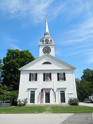
Amherst is a census-designated place (CDP) and the main village in the town of Amherst in Hillsborough County, New Hampshire, United States. The population of the CDP was 697 at the 2020 census, out of 11,753 in the entire town. The village center is listed on the National Register of Historic Places as the Amherst Village Historic District.

<span class="mw-page-title-main">Bradford (CDP), New Hampshire</span> Census-designated place in New Hampshire, United States

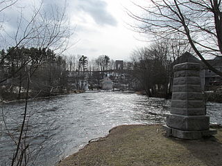
Bradford is a census-designated place (CDP) and the main village in the town of Bradford in Merrimack County, New Hampshire, United States. The population of the CDP was 372 at the 2020 census, out of 1,662 in the entire town.

<span class="mw-page-title-main">Colebrook (CDP), New Hampshire</span> Census-designated place in New Hampshire, United States

Colebrook is a census-designated place (CDP) and the main village in the town of Colebrook, Coös County, New Hampshire, United States. The population of the CDP was 1,201 at the 2020 census, out of 2,084 in the entire town. The CDP population had dropped from 1,394 at the 2010 census.

<span class="mw-page-title-main">Hancock (CDP), New Hampshire</span> Census-designated place in New Hampshire, United States

Hancock is a census-designated place (CDP) and the main village in the town of Hancock in Hillsborough County, New Hampshire, United States. The population of the CDP was 213 at the 2020 census, out of 1,731 in the entire town.

Lincoln is a census-designated place (CDP) and the main village in the town of Lincoln in Grafton County, New Hampshire, United States. The population of the CDP was 969 at the 2020 census, out of 1,631 in the entire town.

Mountain Lakes is a census-designated place (CDP) in the towns of Haverhill and Bath in Grafton County, New Hampshire, United States. It had a population of 504 at the 2020 census.

References

  1. "ArcGIS REST Services Directory". United States Census Bureau. Retrieved September 20, 2022.
  2. "Blodgett Landing CDP, New Hampshire: 2020 DEC Redistricting Data (PL 94-171)". U.S. Census Bureau. Retrieved December 16, 2021.
  3. "Geographic Identifiers: 2010 Demographic Profile Data (G001): Blodgett Landing CDP, New Hampshire". U.S. Census Bureau, American Factfinder. Archived from the original on February 13, 2020. Retrieved October 17, 2017.
  4. "TIGERweb: Blodgett Landing CDP, New Hampshire". Geography Division, U.S. Census Bureau. Retrieved October 17, 2017.
  5. "2021 U.S. Gazetteer Files – New Hampshire". United States Census Bureau. Retrieved December 16, 2021.
  6. "Decennial Census Official Publications". Census.gov. Retrieved March 4, 2024.
  7. 1 2 3 "Profile of General Population and Housing Characteristics: 2010 Census Summary File 1 (DP-1): Blodgett Landing CDP, New Hampshire". U.S. Census Bureau, American Factfinder. Archived from the original on February 13, 2020. Retrieved October 17, 2017.