Bradford (CDP), New Hampshire

Last updated

Bradford, New Hampshire
Bradford Public Library, Bradford NH.jpg
Bradford Public Library
USA New Hampshire location map.svg
Red pog.svg
Bradford
Usa edcp location map.svg
Red pog.svg
Bradford
Coordinates: 43°16′11″N71°57′30″W / 43.26972°N 71.95833°W / 43.26972; -71.95833
Country United States
State New Hampshire
County Merrimack
Town Bradford
Area
[1]
  Total0.81 sq mi (2.10 km2)
  Land0.79 sq mi (2.06 km2)
  Water0.02 sq mi (0.04 km2)
Elevation
685 ft (209 m)
Population
 (2020)
  Total372
  Density468.51/sq mi (180.87/km2)
Time zone UTC-5 (Eastern (EST))
  Summer (DST) UTC-4 (EDT)
ZIP code
03221
Area code 603
FIPS code 33-06900
GNIS feature ID2629717

Bradford is a census-designated place (CDP) and the main village in the town of Bradford in Merrimack County, New Hampshire, United States. The population of the CDP was 372 at the 2020 census, [2] out of 1,662 in the entire town.

Contents

Geography

The CDP occupies the northeastern part of the town of Bradford, at the outlet of Todd Lake. The northern border of the CDP follows the Bradford/Newbury town line, while the southern boundary follows the Warner River and its West Branch. The CDP is bordered to the east by New Hampshire Route 114. [3] Route 114 leads north 12 miles (19 km) to New London and southeast 9 miles (14 km) to Henniker. New Hampshire Route 103 passes through the center of the CDP, leading east 7 miles (11 km) to Interstate 89 in Warner and northwest 13 miles (21 km) to Newport.

According to the U.S. Census Bureau, the Bradford CDP has a total area of 0.81 square miles (2.1 km2), of which 0.02 square miles (0.04 km2), or 1.98%, are water. [4]

Demographics

Historical population
CensusPop.Note
2010 356
2020 3724.5%
U.S. Decennial Census [5]

As of the census of 2010, there were 356 people, 144 households, and 97 families residing in the CDP. There were 174 housing units, of which 30, or 17.2%, were vacant. 14 of the vacant units were seasonal or vacation properties. The racial makeup of the CDP was 95.2% white, 0.3% African American, 1.4% Native American, 0.6% Asian, 0.0% Pacific Islander, 0.3% some other race, and 2.2% from two or more races. 2.2% of the population were Hispanic or Latino of any race. [6]

Of the 144 households in the CDP, 26.4% had children under the age of 18 living with them, 48.6% were headed by married couples living together, 11.8% had a female householder with no husband present, and 32.6% were non-families. 22.2% of all households were made up of individuals, and 7.0% were someone living alone who was 65 years of age or older. The average household size was 2.47, and the average family size was 2.88. [6]

21.1% of residents in the CDP were under the age of 18, 9.8% were from age 18 to 24, 21.1% were from 25 to 44, 36.5% were from 45 to 64, and 11.5% were 65 years of age or older. The median age was 43.4 years. For every 100 females, there were 95.6 males. For every 100 females age 18 and over, there were 103.6 males. [6]

For the period 2011-15, the estimated median annual income for a household was $54,583, and the median income for a family was $63,438. The per capita income for the CDP was $21,501. 9.7% of the population and 8.8% of families were below the poverty line, along with 16.2% of people under the age of 18 and 6.8% of people 65 or older. [7]

Related Research Articles

<span class="mw-page-title-main">Suncook, New Hampshire</span> Census-designated place in New Hampshire, United States

Suncook is a census-designated place (CDP) in Merrimack County, New Hampshire, United States. The population was 5,501 at the 2020 census. Approximately two-thirds of Suncook is located in the town of Pembroke, with the remainder in Allenstown.

<span class="mw-page-title-main">Winchester (CDP), New Hampshire</span> Census-designated place in New Hampshire, United States

Winchester is a census-designated place (CDP) and the main village in the town of Winchester in Cheshire County, New Hampshire, United States. The population of the CDP was 1,606 at the 2020 census, compared to 4,150 in the entire town.

Gorham is a census-designated place (CDP) and the main village in the town of Gorham in Coos County, New Hampshire, United States. The population of the CDP was 1,851 at the 2020 census, out of 2,698 people in the entire town of Gorham.

Whitefield is a census-designated place (CDP) and the main village in the town of Whitefield in Coos County, New Hampshire, United States. The population of the CDP was 1,460 at the 2020 census, out of 2,490 people in the entire town of Whitefield.

<span class="mw-page-title-main">Bristol (CDP), New Hampshire</span> Census-designated place in New Hampshire, United States

Bristol is a census-designated place (CDP) and the main village in the town of Bristol in Grafton County, New Hampshire, United States. The population of the CDP was 1,911 at the 2020 census, out of 3,244 in the entire town.

Hanover is a census-designated place (CDP) and the main village in the town of Hanover in Grafton County, New Hampshire, United States. The population of the CDP was 9,078 at the 2020 census, out of 11,870 in the entire town. The CDP includes the campus of Dartmouth College.

<span class="mw-page-title-main">Plymouth (CDP), New Hampshire</span> Census-designated place in New Hampshire, United States

Plymouth is a census-designated place (CDP) and the main village in the town of Plymouth in Grafton County, New Hampshire, United States. Its population was 4,730 at the 2020 census, out of 6,682 in the entire town. The CDP includes the campus of Plymouth State University.

<span class="mw-page-title-main">Greenville (CDP), New Hampshire</span> Census-designated place in New Hampshire, United States

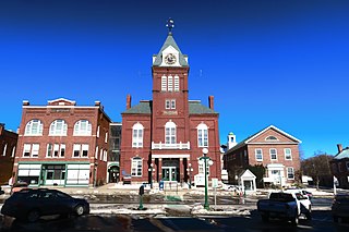
Greenville is a census-designated place (CDP) and the main village in the town of Greenville in Hillsborough County, New Hampshire, United States. The population of the CDP was 1,074 at the 2020 census, out of 1,974 in the entire town.

<span class="mw-page-title-main">Henniker (CDP), New Hampshire</span> Census-designated place in New Hampshire, United States

Henniker is a census-designated place (CDP) and the main village in the town of Henniker in Merrimack County, New Hampshire, United States. The population of the CDP was 3,166 at the 2020 census, out of 6,185 in the entire town. The CDP is the home to New England College.

<span class="mw-page-title-main">Pittsfield (CDP), New Hampshire</span> Census-designated place in New Hampshire, United States

Pittsfield is a census-designated place (CDP) and the main village in the town of Pittsfield in Merrimack County, New Hampshire, United States. The population of the CDP was 1,570 at the 2020 census, out of 4,075 in the entire town.

<span class="mw-page-title-main">Derry (CDP), New Hampshire</span> Census-designated place in New Hampshire, United States

Derry is a census-designated place (CDP) in the town of Derry in Rockingham County, New Hampshire, United States. The CDP comprises the urban center of the town, as well as the village of East Derry and connected suburban areas. The population of the CDP was 22,879 at the 2020 census, out of 34,317 in the entire town.

<span class="mw-page-title-main">Exeter (CDP), New Hampshire</span> Census-designated place in New Hampshire, United States

Exeter is a census-designated place (CDP) and the main village in the town of Exeter, Rockingham County, New Hampshire, United States. The population of the CDP was 10,109 at the 2020 census, out of 16,049 in the entire town.

<span class="mw-page-title-main">Hampton (CDP), New Hampshire</span> Census-designated place in New Hampshire, United States

Hampton is a census-designated place (CDP) comprising the town center and surrounding developed areas of the town of Hampton, Rockingham County, New Hampshire, United States. The population of the CDP was 9,597 at the 2020 census, out of 16,214 in the entire town.

<span class="mw-page-title-main">Londonderry (CDP), New Hampshire</span> Census-designated place in New Hampshire, United States

Londonderry is a census-designated place (CDP) within the town of Londonderry in Rockingham County, New Hampshire, United States. The population of the CDP was 11,645 at the 2020 census, out of 25,826 in the entire town.

<span class="mw-page-title-main">Newport (CDP), New Hampshire</span> Census-designated place in New Hampshire, United States

Newport is a census-designated place (CDP) comprising the main village and surrounding rural land in the town of Newport, Sullivan County, New Hampshire, United States. The population of the CDP was 4,735 at the 2020 census, out of 6,299 in the entire town.

<span class="mw-page-title-main">Newfields (CDP), New Hampshire</span> Census-designated place in New Hampshire, United States

Newfields is a census-designated place (CDP) and the main village within the town of Newfields, Rockingham County, New Hampshire, United States. The population of the CDP was 378 at the 2020 census, out of 1,769 in the entire town.

<span class="mw-page-title-main">Ashland (CDP), New Hampshire</span> Census-designated place in New Hampshire, United States

Ashland is a census-designated place (CDP) and the main village in the town of Ashland in Grafton County, New Hampshire, United States. The population of the CDP was 1,082 at the 2020 census, out of 1,938 in the entire town.

<span class="mw-page-title-main">Colebrook (CDP), New Hampshire</span> Census-designated place in New Hampshire, United States

Colebrook is a census-designated place (CDP) and the main village in the town of Colebrook, Coös County, New Hampshire, United States. The population of the CDP was 1,201 at the 2020 census, out of 2,084 in the entire town. The CDP population had dropped from 1,394 at the 2010 census.

<span class="mw-page-title-main">New London (CDP), New Hampshire</span> Census-designated place in New Hampshire, United States

New London is a census-designated place (CDP) and the primary village in the town of New London in Merrimack County, New Hampshire, United States. The population of the CDP was 1,266 at the 2020 census, out of 4,400 in the entire town. The CDP includes the campus of Colby–Sawyer College.

<span class="mw-page-title-main">Warner (CDP), New Hampshire</span> Census-designated place in New Hampshire, United States

Warner is a census-designated place (CDP) and the main village in the town of Warner in Merrimack County, New Hampshire, United States. The population of the CDP was 453 at the 2020 census, out of 2,937 in the entire town.

References

  1. "ArcGIS REST Services Directory". United States Census Bureau. Retrieved September 20, 2022.
  2. "Bradford CDP, New Hampshire: 2020 DEC Redistricting Data (PL 94-171)". U.S. Census Bureau. Retrieved December 16, 2021.
  3. "TIGERweb: Bradford CDP, New Hampshire". Geography Division, U.S. Census Bureau. Retrieved January 26, 2021.
  4. "2021 U.S. Gazetteer Files – New Hampshire". United States Census Bureau. Retrieved December 16, 2021.
  5. "Decennial Census Official Publications". Census.gov. Retrieved March 4, 2024.
  6. 1 2 3 "Profile of General Population and Housing Characteristics: 2010 Census Summary File 1 (DP-1): Bradford CDP, New Hampshire". U.S. Census Bureau, American Factfinder. Archived from the original on February 13, 2020. Retrieved September 27, 2017.
  7. "Selected Economic Characteristics: 2011-2015 American Community Survey 5-Year Estimates (DP03): Bradford CDP, New Hampshire". U.S. Census Bureau, American Factfinder. Archived from the original on February 13, 2020. Retrieved September 27, 2017.