Salisbury, New Hampshire

Last updated

Salisbury, New Hampshire
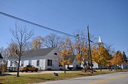
SalisburyNH TownHallAndHistoricSociety.jpg
Old town hall and church (now historic society)
Salisbury, NH Town Seal.png
Merrimack County New Hampshire incorporated and unincorporated areas Salisbury highlighted.svg
Location in Merrimack County and the state of New Hampshire
Coordinates: 43°22′43″N71°43′03″W / 43.37861°N 71.71750°W / 43.37861; -71.71750
CountryUnited States
State New Hampshire
County Merrimack
Incorporated 1768
VillagesSalisbury
Salisbury Heights
West Salisbury
Government
   Board of Selectmen Brett Walker, Chair
John Herbert
Jim Hoyt
  Town AdministratorApril Rollins
Area
[1]
  Total39.8 sq mi (103.1 km2)
  Land39.6 sq mi (102.5 km2)
  Water0.2 sq mi (0.6 km2)  0.56%
Elevation
819 ft (250 m)
Population
 (2020) [2]
  Total1,422
  Density36/sq mi (13.9/km2)
Time zone UTC−5 (Eastern)
  Summer (DST) UTC−4 (Eastern)
ZIP codes
03268 (Salisbury)
03235 (Franklin)
03278 (Warner)
Area code 603
FIPS code 33-66980
GNIS feature ID0873714
Website www.salisburynh.org

Salisbury is a town in Merrimack County, New Hampshire, United States. The population was 1,422 at the 2020 census. [2]

Contents

History

While still part of Massachusetts, the town was granted as "Baker's Town" after Captain Thomas Baker in 1736. After the border between Massachusetts and New Hampshire was fixed, the town was on the New Hampshire side of the border. It was re-granted by the Masonian proprietors in 1749 with the name "Stevenstown", after Colonel Ebenezer Stevens of Kingston, New Hampshire, and settled as early as 1750. Additionally known as "Gerrishtown" and "New Salisbury", the name "Salisbury" was taken when the town incorporated in 1768. [3]

Geography

According to the United States Census Bureau, the town has a total area of 39.8 square miles (103.1 km2), of which 39.6 square miles (102.5 km2) are land and 0.2 square miles (0.6 km2) are water, comprising 0.56% of the town. [1] The highest point in Salisbury is along its western boundary, where the eastern slopes of Mount Kearsarge climb to 1,910 feet (580 m) above sea level.

The Blackwater River, a southward-flowing tributary of the Contoocook River and part of the Merrimack River watershed, runs through the western side of the town. A popular fishing and recreation spot is The Bay, a natural lake-like section of the river. The east side of the town is drained by streams that run directly to the Merrimack River.

Adjacent municipalities

Demographics

Historical population
CensusPop.Note
1790 1,372
1800 1,76728.8%
1810 1,9138.3%
1820 2,0165.4%
1830 1,379−31.6%
1840 1,332−3.4%
1850 1,228−7.8%
1860 1,191−3.0%
1870 897−24.7%
1880 795−11.4%
1890 655−17.6%
1900 604−7.8%
1910 478−20.9%
1920 390−18.4%
1930 350−10.3%
1940 3685.1%
1950 42314.9%
1960 415−1.9%
1970 58941.9%
1980 78132.6%
1990 1,06135.9%
2000 1,1377.2%
2010 1,38221.5%
2020 1,4222.9%
U.S. Decennial Census [2] [4]

At the 2000 census there were 1,137 people, 435 households, and 324 families in the town. The population density was 28.5 inhabitants per square mile (11.0/km2). There were 514 housing units at an average density of 12.9 per square mile (5.0/km2). The racial makeup of the town was 97.80% White, 0.70% African American, 0.26% Asian, 0.09% Pacific Islander, 0.18% from other races, and 0.97% from two or more races. Hispanic or Latino of any race were 0.70%. [5]

Of the 435 households 31.7% had children under the age of 18 living with them, 69.0% were married couples living together, 4.1% had a female householder with no husband present, and 25.3% were non-families. 17.0% of households were one person and 6.2% were one person aged 65 or older. The average household size was 2.61 and the average family size was 3.00.

The age distribution was 24.5% under the age of 18, 6.1% from 18 to 24, 28.2% from 25 to 44, 31.1% from 45 to 64, and 10.0% 65 or older. The median age was 40 years. For every 100 females, there were 103.4 males. For every 100 females age 18 and over, there were 96.3 males.

The median household income was $55,000 and the median family income was $62,321. Males had a median income of $36,991 versus $28,462 for females. The per capita income for the town was $23,112. About 0.6% of families and 1.9% of the population were below the poverty threshold, including 0.7% of those under age 18 and 4.6% of those age 65 or over.

Notable people

Related Research Articles

<span class="mw-page-title-main">Barnstead, New Hampshire</span> Town in New Hampshire, United States

Barnstead is a town in Belknap County, New Hampshire, United States. The population was 4,915 at the 2020 census, up from 4,593 at the 2010 census. Home to the Suncook Lakes, Barnstead includes the villages of Center Barnstead, Barnstead Parade and South Barnstead.

<span class="mw-page-title-main">Brookfield, New Hampshire</span> Town in New Hampshire, United States

Brookfield is a town in Carroll County, New Hampshire, United States. The population was 755 at the 2020 census.

<span class="mw-page-title-main">Westmoreland, New Hampshire</span> Town in New Hampshire, United States

Westmoreland is a town in Cheshire County, New Hampshire, United States. The population was 1,706 at the 2020 census, down from 1,874 at the 2010 census. Westmoreland is historically an agricultural town, with much arable farmland.

<span class="mw-page-title-main">Alexandria, New Hampshire</span> Town in New Hampshire, United States

Alexandria is a town in Grafton County, New Hampshire, United States. The population was 1,776 at the 2020 census, up from 1,613 at the 2010 census. Newfound Lake is in the northeast corner, with Wellington State Park on the western shore. The town is home to Welton Falls State Forest. Cardigan Mountain State Park, with Mount Cardigan, is in the west. Another attraction is Mowglis Mountain, named for Rudyard Kipling's Jungle Book hero.

<span class="mw-page-title-main">Campton, New Hampshire</span> Town in New Hampshire, United States

Campton is a town in Grafton County, New Hampshire, United States. The population was 3,343 at the 2020 census. Campton, which includes the villages of Blair, Campton Hollow, Lower Campton and West Campton, is home to Blair State Forest and Livermore Falls State Forest. It is located in the foothills of the White Mountains, and parts of the White Mountain National Forest are in the northeast and northwest.

<span class="mw-page-title-main">Groton, New Hampshire</span> Town in New Hampshire, United States

Groton is a town in Grafton County, New Hampshire, United States. The population was 569 at the 2020 census.

<span class="mw-page-title-main">Hebron, New Hampshire</span> Town in New Hampshire, United States

Hebron is a town in Grafton County, New Hampshire, United States. The population was 632 at the 2020 census. Settlements include the town center and the village of East Hebron.

<span class="mw-page-title-main">Deering, New Hampshire</span> Town in New Hampshire, United States

Deering is a town in Hillsborough County, New Hampshire, United States. The population was 1,904 at the 2020 census.

<span class="mw-page-title-main">Greenfield, New Hampshire</span> Town in New Hampshire, United States

Greenfield is a town in Hillsborough County, New Hampshire, United States. The population was 1,716 at the 2020 census. Greenfield is home to the Crotched Mountain Rehabilitation Center, to Greenfield State Park, and to part of the Wapack Trail.

<span class="mw-page-title-main">Lyndeborough, New Hampshire</span> Town in New Hampshire, United States

Lyndeborough is a town in Hillsborough County, New Hampshire, United States. The population was 1,702 at the 2020 census.

<span class="mw-page-title-main">Mason, New Hampshire</span> Town in New Hampshire, United States

Mason is a town in Hillsborough County, New Hampshire, United States. The population was 1,448 at the 2020 census. Mason, together with Wilton, is home to Russell-Abbott State Forest.

<span class="mw-page-title-main">Boscawen, New Hampshire</span> Town in New Hampshire, United States

Boscawen is a town in Merrimack County, New Hampshire, United States. The population was 3,998 at the 2020 census.

<span class="mw-page-title-main">Bradford, New Hampshire</span> Town in New Hampshire, United States

Bradford is a town in Merrimack County, New Hampshire, United States. The population was 1,662 at the 2020 census. The main village of the town, where 372 people resided at the 2020 census, is defined as the Bradford census-designated place (CDP), and is located in the northeast part of the town, west of the junction of New Hampshire routes 103 and 114. The town also includes the village of Bradford Center.

<span class="mw-page-title-main">Danbury, New Hampshire</span> Town in New Hampshire, United States

Danbury is a town in Merrimack County, New Hampshire, United States. The population was 1,250 at the 2020 census.

<span class="mw-page-title-main">Epsom, New Hampshire</span> Town in New Hampshire, United States

Epsom is a town in Merrimack County, New Hampshire, United States. The population was 4,834 at the 2020 census.

<span class="mw-page-title-main">Franklin, New Hampshire</span> City in New Hampshire, United States

Franklin is a city in Merrimack County, New Hampshire, United States. At the 2020 census, the population was 8,741, the lowest figure of New Hampshire's 13 cities. Franklin includes the village of West Franklin.

<span class="mw-page-title-main">Sutton, New Hampshire</span> Town in New Hampshire, United States

Sutton is a town in Merrimack County, New Hampshire, United States. The population was 1,978 at the 2020 census. Sutton includes the villages of Sutton Mills, North Sutton, South Sutton and East Sutton. North Sutton is home to Wadleigh State Park on Kezar Lake.

<span class="mw-page-title-main">Warner, New Hampshire</span> Town in New Hampshire, United States

Warner is a town in Merrimack County, New Hampshire, United States. The population was 2,937 at the 2020 census. The town is home to Magdalen College of the Liberal Arts, Rollins State Park and Mount Kearsarge State Forest.

<span class="mw-page-title-main">New Durham, New Hampshire</span> Town in New Hampshire, United States

New Durham is a town in Strafford County, New Hampshire, United States. The population was 2,693 at the 2020 census. It is drained by the Merrymeeting, Cocheco and Ela rivers, and is known for Merrymeeting Lake. New Durham is home to the Powder Mill Fish Hatchery, located on Merrymeeting Road. Also located here is the Lions Club's Camp Pride, a camp for children and adults with special needs.

<span class="mw-page-title-main">Wentworth, New Hampshire</span> Town in New Hampshire, United States

Wentworth is a town in Grafton County, New Hampshire, United States. The population was 845 at the 2020 census, down from 911 at the 2010 census. The town is home to Plummer's Ledge Natural Area, and part of the White Mountain National Forest is in the northeast. The town has a picturesque common, presided over by a Federal-style church and bordered by antique homes.

References

  1. 1 2 "2021 U.S. Gazetteer Files – New Hampshire". United States Census Bureau. Retrieved December 15, 2021.
  2. 1 2 3 "Salisbury town, Merrimack County, New Hampshire: 2020 DEC Redistricting Data (PL 94-171)". U.S. Census Bureau. Retrieved December 15, 2021.
  3. Coolidge, Austin J.; John B. Mansfield (1859). A History and Description of New England. Boston, Massachusetts: A.J. Coolidge. pp.  641–642. coolidge mansfield history description new england 1859.
  4. "Census of Population and Housing". Census.gov. Retrieved June 4, 2016.
  5. "U.S. Census website". United States Census Bureau . Retrieved January 31, 2008.