Northern boundary of Massachusetts

Last updated
1894 map of Massachusetts Map of Massachusetts.jpg
1894 map of Massachusetts

The northern boundary of the U.S. state of Massachusetts adjoins two other states: Vermont and New Hampshire. The majority of the boundary is roughly a straight line from the northwest corner of the state ( 42°44′44.7″N73°15′54.13″W / 42.745750°N 73.2650361°W / 42.745750; -73.2650361 NAD27 [1] ) east to a point in Dracut, just north of Lowell. East of that point, the border is a series of line segments about 3 miles (5 km) north of the curving Merrimack River, ending in the Atlantic Ocean.

Contents

History

The 1629 charter of the Massachusetts Bay Colony gave the colony the land between the Merrimack River and Charles River. Specifically, the southern border was to be the line of latitude either 3 miles (5 km) south of Massachusetts Bay or 3 miles south of the southernmost bend of the Charles River, whichever was farther south. The northern border was to be 3 miles north of the northernmost bend of the Merrimack River. Between these lines of latitude the grant extended from the Atlantic to the Pacific. In 1629 the rivers had not been fully explored and the actual borders of the colony were uncertain. It turned out that the southernmost bend of the Charles is south of the southern curve of Massachusetts Bay. The line of latitude three miles south of the river's southernmost bend, approximately 42°2′ north, forms the basis of the southern border of Massachusetts to the present day. The Merrimack River turned out to originate farther north than expected, flowing south for most of its course and only turning eastward in its last several miles. Thus the 1629 grant gave the colony most of what is today New Hampshire and all of the original 1629 grant that formed the basis of colonial New Hampshire, but it took many decades before this was fully understood. [2]

A new charter was granted to the Province of Massachusetts Bay in 1691, which merged the Colony with the Colony of New Plymouth, as well as present-day Maine and New Brunswick. The northern boundary of what was now the southern piece remained as defined in 1629. [1]

A map showing the rival claims of Massachusetts Bay and New Hampshire Nhcolony.png
A map showing the rival claims of Massachusetts Bay and New Hampshire

The Province of New Hampshire and Province of Massachusetts Bay had disagreements over their mutual boundaries. With respect to the southern boundary of New Hampshire, the two provinces disagreed on the meaning of "three miles northward of the Merrimack River, or any part thereof". New Hampshire drew a line from three miles north of the mouth of the river, while Massachusetts claimed a line three miles north of the northernmost part of the river, taking its territory far north past what is now Concord, New Hampshire. New Hampshire appealed to King George II, who in 1740 decreed the boundary to run along a curved line three miles from the river between the ocean and a point three miles north of Pawtucket Falls (Lowell), where the river begins to turn north. From there a line was to be drawn due west to meet the western boundary of Massachusetts (fixed in 1773 with the Province of New York). The line actually runs slightly northwest to southeast, so it follows no line of latitude. This gave New Hampshire even more than it had claimed, as Pawtucket Falls was south of the mouth of the Merrimack. At this time, the present northern boundary of Massachusetts was established. [1]

The location where these two surveyed lines met (the straight westward line and the curved line following the Merrimack River) was marked by a pine tree called the "Old Boundary Pine". The tree was marked by George Mitchell, one of the surveyors, on March 21, 1741 to indicate the location where the lines met. The pine tree is long gone, but the point (officially at 42°41′50.25″N71°19′22.02″W / 42.6972917°N 71.3227833°W / 42.6972917; -71.3227833 ) [3] [lower-alpha 1] is today marked by a granite monument known as the Boundary Pine Monument, the current form of which was placed in 1890. Elsewhere, the boundary are made by 50 large granite markers, along with several other markers, including a copper bolt set in granite at the tripoint between Vermont, Massachusetts, and New Hampshire. The Old Boundary Pine was located 57.8 miles (93.0 km) east of this point. The "curved" segments roughly following the course of the Merrimack at a distance 3 miles north of it are not true curves, but rather a series of line segments approximating the curved course of the river. Another granite marker, also placed in 1890, stands on the beach between Salisbury, Massachusetts and Seabrook, New Hampshire at 80 feet from the high tide line, marking the end of the surveyed border, with the border taken to extend into the Atlantic Ocean to the "limit of State jurisdiction." [5]

New Hampshire claimed all the land west to roughly the present western boundary of Vermont, while New York claimed east to the Connecticut River, Vermont's present eastern boundary; thus both states claimed all of Vermont. A ruling by King George III established the ordinary low-water line on the west bank of the Connecticut River to be the border, but the territory between the Connecticut River and Lake Champlain – which had been sold off by New Hampshire – declared independence in 1777 as the Vermont Republic. New Hampshire gave up its claim to Vermont with a boundary agreement in 1782, and New York gave up its claim to Vermont, contingent upon Vermont's admission to the Union, in 1790 (Vermont was admitted to the Union in 1791). [1]

See also

Notes

  1. The official coordinates may not reflect the actual position of the marker, which is located on private property in the field of a farm off of Marsh Road in Dracut. [4]

Related Research Articles

<span class="mw-page-title-main">Interstate 89</span> Interstate in Vermont and New Hampshire

Interstate 89 (I-89) is an Interstate Highway in the New England region of the United States traveling from Bow, New Hampshire, to the Canada–United States border between Highgate Springs, Vermont, and Saint-Armand, Quebec. As with all odd-numbered primary Interstates, I-89 is signed as a north–south highway. However, it follows a primarily northwest-to-southeast path. The route forms a major part of the main connection between the cities of Montreal and Boston. In Quebec, the route continues as Route 133. The eventual completion of Autoroute 35 from Montreal will lead to a nonstop limited-access highway route between the two cities, following I-93 south from I-89's terminus. The largest cities directly served by I-89 are Concord, the state capital of New Hampshire; Montpelier, the state capital of Vermont; and Burlington, Vermont. I-89 is one of three main Interstate highways whose route is located entirely within New England, along with I-91 and I-93.

<span class="mw-page-title-main">Methuen, Massachusetts</span> City in Massachusetts, United States

Methuen is a 23-square-mile city in Essex County, Massachusetts, United States. The population was 53,059 at the 2020 census. Methuen lies along the northwestern edge of Essex County, just east of Middlesex County and just south of Rockingham County, New Hampshire. The city is bordered by Haverhill to the northeast, North Andover to the southeast, Lawrence and Andover to the south, Dracut to the west, Pelham, New Hampshire to the northwest, and Salem, New Hampshire to the north. Methuen is located 17 miles (27 km) southwest from Newburyport, 30 miles (48 km) north-northwest of Boston and 25 miles (40 km) south-southeast of Manchester, New Hampshire.

<span class="mw-page-title-main">Dracut, Massachusetts</span> Town in Massachusetts, United States

Dracut is a town in Middlesex County. At the 2020 census, the town's population was 32,617, making it the second most populous town in Massachusetts with an open town meeting system of governance. The town covers a total area of 21.36 square miles, 0.5 square miles of which are water.

<span class="mw-page-title-main">Pelham, New Hampshire</span> Town in New Hampshire, United States

Pelham is a town in Hillsborough County, New Hampshire, United States. The population was 14,222 at the 2020 census, up from 12,897 at the 2010 census.

<span class="mw-page-title-main">Bow, New Hampshire</span> Town in New Hampshire, United States

Bow is a town in Merrimack County, New Hampshire, United States. The population was 8,229 at the 2020 census, up from 7,519 at the 2010 census, an increase of 9.4%.

<span class="mw-page-title-main">Merrimack River</span> River in New Hampshire and Massachusetts, United States

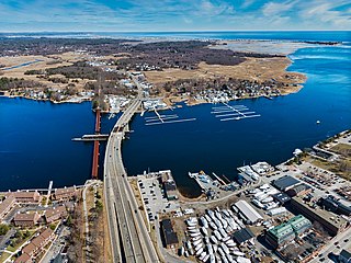
The Merrimack River is a 117-mile-long (188 km) river in the northeastern United States. It rises at the confluence of the Pemigewasset and Winnipesaukee rivers in Franklin, New Hampshire, flows southward into Massachusetts, and then flows northeast until it empties into the Gulf of Maine at Newburyport. From Pawtucket Falls in Lowell, Massachusetts, onward, the Massachusetts–New Hampshire border is roughly calculated as the line three miles north of the river.

<span class="mw-page-title-main">Massachusetts Bay Colony</span> 1630–1691 English colony in North America

The Massachusetts Bay Colony (1628–1691), more formally the Colony of Massachusetts Bay, was an English settlement on the east coast of North America around the Massachusetts Bay, one of the several colonies later reorganized as the Province of Massachusetts Bay. The lands of the settlement were in southern New England, with initial settlements on two natural harbors and surrounding land about 15.4 miles (24.8 km) apart—the areas around Salem and Boston, north of the previously established Plymouth Colony. The territory nominally administered by the Massachusetts Bay Colony covered much of central New England, including portions of Massachusetts, Maine, New Hampshire, and Connecticut.

<span class="mw-page-title-main">Connecticut River</span> River in the New England region of the United States

The Connecticut River is the longest river in the New England region of the United States, flowing roughly southward for 406 miles (653 km) through four states. It rises 300 yards south of the U.S. border with Quebec, Canada, and discharges at Long Island Sound. Its watershed encompasses 11,260 square miles (29,200 km2), covering parts of five U.S. states and one Canadian province, via 148 tributaries, 38 of which are major rivers. It produces 70% of Long Island Sound's fresh water, discharging at 18,400 cubic feet (520 m3) per second.

<span class="mw-page-title-main">Province of New Hampshire</span> British colony in North America (1629–1641, 1679–1686, 1689–1776)

The Province of New Hampshire was a colony of England and later a British province in New England. The name was first given in 1629 to the territory between the Merrimack and Piscataqua rivers on the eastern coast of North America, and was named after the county of Hampshire in southern England by Captain John Mason, its first named proprietor. In 1776 the province established an independent state and government, the State of New Hampshire, and joined with twelve other colonies to form the United States.

<span class="mw-page-title-main">New Hampshire Grants</span> Land grants in colonial New Hampshire (1749-64); later became the Republic of Vermont

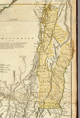
The New Hampshire Grants or Benning Wentworth Grants were land grants made between 1749 and 1764 by the colonial governor of the Province of New Hampshire, Benning Wentworth. The land grants, totaling about 135, were made on land claimed by New Hampshire west of the Connecticut River, territory that was also claimed by the Province of New York. The resulting dispute led to the eventual establishment of the Vermont Republic, which later became the U.S. state of Vermont.

<span class="mw-page-title-main">Province of Maine</span> 17th century English colonies in North America

The Province of Maine refers to any of the various English colonies established in the 17th century along the northeast coast of North America, within portions of the present-day U.S. states of Maine, New Hampshire, and Vermont, and the Canadian provinces of Quebec and New Brunswick. It existed through a series of land patents made by the kings of England during this era, and included New Somersetshire, Lygonia, and Falmouth. The province was incorporated into the Massachusetts Bay Colony during the 1650s, beginning with the formation of York County, Massachusetts, which extended from the Piscataqua River to just east of the mouth of the Presumpscot River in Casco Bay. Eventually, its territory grew to encompass nearly all of present-day Maine.

Title I: The State and Its Government, is the collection of New Hampshire Revised Statutes Annotated which relate to the state's government as a whole. Like other portions of the RSAs, the Title is divided into Chapters and Sections organized in numbers and subsections organized in lowercase letters.

<span class="mw-page-title-main">History of Massachusetts</span> Overview of the history of Massachusetts

The area that is now Massachusetts was colonized by English settlers in the early 17th century and became the Commonwealth of Massachusetts in the 18th century. Before that, it was inhabited by a variety of Native American tribes. Massachusetts is named after the Massachusett tribe that inhabited the area of present-day Greater Boston. The Pilgrim Fathers who sailed on the Mayflower established the first permanent settlement in 1620 at Plymouth Colony which set precedents but never grew large. A large-scale Puritan migration began in 1630 with the establishment of the Massachusetts Bay Colony, and that spawned the settlement of other New England colonies.

Beaver Brook is a 30.7-mile-long (49.4 km) river located in New Hampshire and Massachusetts in the United States. It is a tributary of the Merrimack River, part of the Gulf of Maine watershed.

The 45th parallel north is a circle of latitude that is 45 degrees north of Earth's equator. It crosses Europe, Asia, the Pacific Ocean, North America, and the Atlantic Ocean. The 45th parallel north is often called the halfway point between the equator and the North Pole, but the true halfway point is 16.0 km (9.9 mi) north of it because Earth is an oblate spheroid; that is, it bulges at the equator and is flattened at the poles.

<span class="mw-page-title-main">Merrimack Valley</span> Region in the U.S. states of New Hampshire and Massachusetts

The Merrimack Valley is a bi-state region along the Merrimack River in the U.S. states of New Hampshire and Massachusetts. The Merrimack is one of the larger waterways in New England and has helped to define the livelihood and culture of those living along it for millennia.
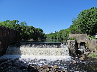
<span class="mw-page-title-main">Pawtucket Falls (Massachusetts)</span> Waterfall on the Merrimack River at Lowell, Massachusetts

<span class="mw-page-title-main">Geology of New Hampshire</span> Overview of the geology of the U.S. state of New Hampshire

The geology of New Hampshire is similar to that of the rest of New England in comprising a series of metamorphosed sedimentary and volcanic rocks of Late Proterozoic to Devonian age, intruded by many plutons and dikes ranging in age from Late Proterozoic to early Cretaceous. New Hampshire is known as "the Granite State", but less than half is underlain by granite; much of it is schist or gneiss, both of which are metamorphic rocks.

References

  1. 1 2 3 4 Franklin K. VanZandt, Boundaries of the United States and the Several States, USGS Bulletin 1212, 1966
  2. Hubbard, Bill Jr. (2009). American Boundaries: the Nation, the States, the Rectangular Survey . University of Chicago Press. pp.  14–15. ISBN   978-0-226-35591-7.
  3. Van Zandt, Franklin K. (1966). Boundaries of the United States and the Several States (PDF). United States Geological Survey. p. 62.
  4. "Fire towers". double-d Mountain Runner. May 7, 2014. Retrieved December 28, 2020 via blogspot.com.
  5. Douglas, Edward Morehouse (1923). Boundaries, Areas, Geographic Centers and Altitudes of the United States and the Several States: With a Brief Record of Important Changes in Their Territory. U.S. Government Printing Office. Retrieved 4 November 2015.