Hill, New Hampshire

Last updated

Hill, New Hampshire
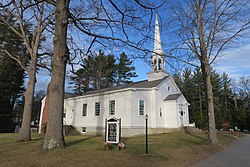
Hill Village Bible Church, Hill NH.jpg
Hill Village Bible Church
Merrimack County New Hampshire incorporated and unincorporated areas Hill highlighted.svg
Location in Merrimack County and the state of New Hampshire
Coordinates: 43°31′18″N71°42′05″W / 43.52167°N 71.70139°W / 43.52167; -71.70139
Country United States
State New Hampshire
County Merrimack
Incorporated 1778
Villages
  • Hill
  • Hill Center
  • Murray Hill
Government
   Board of Selectmen
  • Shaun Bresnahan Jr.
  • Frank Razzaboni
  • Stephen Thomson
Area
[1]
  Total26.73 sq mi (69.23 km2)
  Land26.55 sq mi (68.77 km2)
  Water0.18 sq mi (0.46 km2)  0.66%
Elevation
453 ft (138 m)
Population
 (2020) [2]
  Total1,017
  Density38/sq mi (14.8/km2)
Time zone UTC-5 (Eastern)
  Summer (DST) UTC-4 (Eastern)
ZIP codes
03243 (Hill)
03230 (Danbury)
Area code 603
FIPS code 33-35860
GNIS feature ID0873624
Website www.townofhillnh.org

Hill is a town in Merrimack County, New Hampshire, United States. The population was 1,017 at the 2020 census. [2] It is home to William Thomas State Forest.

Contents

History

Originally granted as "New Chester" in 1753, the town took the name "Hill" in 1837 in honor of Isaac Hill, [3] governor of New Hampshire from 1836 to 1839. To accommodate the construction of the Franklin Falls Dam, the village of Hill was relocated in 1941. [4]

Geography

According to the United States Census Bureau, the town has a total area of 26.7 square miles (69.2 km2), of which 26.6 square miles (68.8 km2) are land and 0.2 square miles (0.5 km2) are water, comprising 0.66% of the town. [1] The Pemigewasset River forms the eastern boundary of the town, and its tributary the Smith River forms two portions of the northern boundary. The southwestern corner of the town drains south via Mountain Brook to the Blackwater River in neighboring Andover, a tributary of the Contoocook River. Via the Pemigewasset and Contoocook rivers, Hill lies fully within the Merrimack River watershed. [5]

The highest point in town is Dickinson Hill, [6] with an approximate elevation of 1,910 feet (580 m) above sea level.

Adjacent municipalities

Demographics

Historical population
CensusPop.Note
1870 620
1880 6677.6%
1890 548−17.8%
1900 60310.0%
1910 556−7.8%
1920 500−10.1%
1930 468−6.4%
1940 4986.4%
1950 310−37.8%
1960 39627.7%
1970 45013.6%
1980 73663.6%
1990 81410.6%
2000 99221.9%
2010 1,0899.8%
2020 1,017−6.6%
U.S. Decennial Census [2] [7]

At the 2000 census there were 992 people, 382 households, and 271 families living in the town. The population density was 37.1 inhabitants per square mile (14.3/km2). There were 436 housing units at an average density of 16.3 per square mile (6.3/km2). The racial makeup of the town was 98.99% White, 0.10% African American, 0.10% Native American, 0.40% Asian, 0.10% Pacific Islander, and 0.30% from two or more races. Hispanic or Latino of any race were 0.20%. [8]

Of the 382 households 33.0% had children under the age of 18 living with them, 57.9% were married couples living together, 8.4% had a female householder with no husband present, and 28.8% were non-families. 21.2% of households were one person and 8.1% were one person aged 65 or older. The average household size was 2.60 and the average family size was 3.01.

The age distribution was 26.7% under the age of 18, 6.1% from 18 to 24, 31.3% from 25 to 44, 25.7% from 45 to 64, and 10.2% 65 or older. The median age was 39 years. For every 100 females, there were 102.4 males. For every 100 females age 18 and over, there were 100.8 males.

The median household income was $48,333 and the median family income was $50,000. Males had a median income of $32,120 versus $24,313 for females. The per capita income for the town was $21,004. About 2.9% of families and 4.2% of the population were below the poverty line, including 1.2% of those under age 18 and none of those age 65 or over.

Education

Hill has one school, Jennie D. Blake Elementary School, which serves students in kindergarten through sixth grade. The school was named for Jennie Lind Dickerson Blake, a Hill resident who was born on July 16, 1878. As of 2017, 68 students were enrolled in the school.

Notable people

Related Research Articles

<span class="mw-page-title-main">Merrimack County, New Hampshire</span> County in New Hampshire, United States

Merrimack County is a county in the U.S. state of New Hampshire. As of the 2020 Census, the population was 153,808, making it the third most populous county in New Hampshire. Its county seat is Concord, the state capital. The county was organized in 1823 from parts of Hillsborough and Rockingham counties, and is named for the Merrimack River. Merrimack County comprises the Concord, NH Micropolitan Statistical Area, which in turn constitutes a portion of the Boston–Worcester–Providence, MA–RI–NH–CT Combined Statistical Area. In 2010, the center of population of New Hampshire was located in Merrimack County, in the town of Pembroke.

<span class="mw-page-title-main">Ellsworth, New Hampshire</span> Town in New Hampshire, United States

Ellsworth is a town in Grafton County, New Hampshire, United States. The population was 93 at the 2020 census.

<span class="mw-page-title-main">Thornton, New Hampshire</span> Town in New Hampshire, United States

Thornton is a town in Grafton County, New Hampshire, United States. The population was 2,708 at the 2020 census, up from 2,490 at the 2010 census.

<span class="mw-page-title-main">Deering, New Hampshire</span> Town in New Hampshire, United States

Deering is a town in Hillsborough County, New Hampshire, United States. The population was 1,904 at the 2020 census.

<span class="mw-page-title-main">Greenfield, New Hampshire</span> Town in New Hampshire, United States

Greenfield is a town in Hillsborough County, New Hampshire, United States. The population was 1,716 at the 2020 census. Greenfield is home to the Crotched Mountain Rehabilitation Center, to Greenfield State Park, and to part of the Wapack Trail.

<span class="mw-page-title-main">Andover, New Hampshire</span> Town in New Hampshire, United States

Andover is a town in Merrimack County, New Hampshire, United States. The population was 2,406 at the 2020 census. Andover includes the villages of Cilleyville, Potter Place, East Andover, and West Andover, in addition to the town center. The town is home to Ragged Mountain State Forest and Proctor Academy, a private coeducational preparatory school.

<span class="mw-page-title-main">Boscawen, New Hampshire</span> Town in New Hampshire, United States

Boscawen is a town in Merrimack County, New Hampshire, United States. The population was 3,998 at the 2020 census.

<span class="mw-page-title-main">Danbury, New Hampshire</span> Town in New Hampshire, United States

Danbury is a town in Merrimack County, New Hampshire, United States. The population was 1,250 at the 2020 census.

<span class="mw-page-title-main">Franklin, New Hampshire</span> City in New Hampshire, United States

Franklin is a city in Merrimack County, New Hampshire, United States. At the 2020 census, the population was 8,741, the lowest figure of New Hampshire's 13 cities. Franklin includes the village of West Franklin.

<span class="mw-page-title-main">Hopkinton, New Hampshire</span> Town in New Hampshire, United States

Hopkinton is a town in Merrimack County, New Hampshire, United States. The population was 5,914 at the 2020 census. The town has three distinct communities: Hopkinton village, mainly a residential area in the center of the town; Contoocook, the town's business hub, located in the north; and West Hopkinton, within the more agricultural portion of the town. The town is home to the Hopkinton State Fair, adjacent to Contoocook village, and to the historic Contoocook Railroad Depot and the Contoocook Railroad Bridge, the oldest covered railroad bridge in the United States.

<span class="mw-page-title-main">Newbury, New Hampshire</span> Town in New Hampshire, United States

Newbury is a town in Merrimack County, New Hampshire, United States. The population was 2,172 at the 2020 census.

<span class="mw-page-title-main">Salisbury, New Hampshire</span> Town in New Hampshire, United States

Salisbury is a town in Merrimack County, New Hampshire, United States. The population was 1,422 at the 2020 census.

<span class="mw-page-title-main">Sutton, New Hampshire</span> Town in New Hampshire, United States

Sutton is a town in Merrimack County, New Hampshire, United States. The population was 1,978 at the 2020 census. Sutton includes the villages of Sutton Mills, North Sutton, South Sutton and East Sutton. North Sutton is home to Wadleigh State Park on Kezar Lake.

<span class="mw-page-title-main">Webster, New Hampshire</span> Town in New Hampshire, United States

Webster is a town in Merrimack County, New Hampshire, United States. The population was 1,913 at the 2020 census.

<span class="mw-page-title-main">Wilmot, New Hampshire</span> Town in New Hampshire, United States

Wilmot is a town in Merrimack County, New Hampshire, United States. The population was 1,407 at the 2020 census. The town includes the communities of Wilmot, Wilmot Flat, and North Wilmot.

<span class="mw-page-title-main">Springfield, New Hampshire</span> Place in New Hampshire, United States

Springfield is a town in Sullivan County, New Hampshire, United States. The population was 1,259 at the 2020 census. Gile State Forest is located within the town.

<span class="mw-page-title-main">Plymouth (CDP), New Hampshire</span> Census-designated place in New Hampshire, United States

Plymouth is a census-designated place (CDP) and the main village in the town of Plymouth in Grafton County, New Hampshire, United States. Its population was 4,730 at the 2020 census, out of 6,682 in the entire town. The CDP includes the campus of Plymouth State University.

<span class="mw-page-title-main">Henniker (CDP), New Hampshire</span> Census-designated place in New Hampshire, United States

Henniker is a census-designated place (CDP) and the main village in the town of Henniker in Merrimack County, New Hampshire, United States. The population of the CDP was 3,166 at the 2020 census, out of 6,185 in the entire town. The CDP is the home to New England College.

<span class="mw-page-title-main">Henniker, New Hampshire</span> Town in New Hampshire, United States

Henniker is a town in Merrimack County, New Hampshire, United States. As of the 2020 census, the reported total population of the town was 6,185, although the figure, 27.9% greater than the 2010 population, has been questioned by local officials. Henniker is home to New England College and Pats Peak Ski Area. Henniker is a college town and resort area, featuring both skiing and white-water kayaking.

<span class="mw-page-title-main">Hillsborough, New Hampshire</span> Town in New Hampshire, United States

Hillsborough, frequently spelled Hillsboro, is a town in Hillsborough County, New Hampshire, United States. The population was 5,939 at the 2020 census. The town is home to Fox State Forest and part of Low State Forest.

References

  1. 1 2 "2021 U.S. Gazetteer Files – New Hampshire". United States Census Bureau. Retrieved December 14, 2021.
  2. 1 2 3 "Hill town, Merrimack County, New Hampshire: 2020 DEC Redistricting Data (PL 94-171)". U.S. Census Bureau. Retrieved December 14, 2021.
  3. Gannett, Henry (1905). The Origin of Certain Place Names in the United States. Govt. Print. Off. pp.  156.
  4. John F. Coggswell, "New Home Town". Saturday Evening Post, February 14, 1942, p. 22-23, 44, 46
  5. Foster, Debra H.; Batorfalvy, Tatianna N.; Medalie, Laura (1995). Water Use in New Hampshire: An Activities Guide for Teachers. U.S. Department of the Interior and U.S. Geological Survey.
  6. U.S. Geological Survey Geographic Names Information System: Dickinson Hill
  7. "Census of Population and Housing". Census.gov. Retrieved June 4, 2016.
  8. "U.S. Census website". United States Census Bureau . Retrieved January 31, 2008.
  9. "National Governors Association". Gov. Augustus C. French. NGA. Retrieved April 30, 2024.