
Salem is a town in Rockingham County, New Hampshire, United States. The population was 30,089 at the 2020 census and an estimated 30,647 in 2022. Salem is a northern suburb of Boston located on Interstate 93. As the first town along I-93 northbound in New Hampshire, which lacks any state sales tax, Salem has grown into a regional commercial hub for the northern section of Greater Boston, anchored by the Mall at Rockingham Park and Tuscan Village. Other major sites include Canobie Lake Park, a large amusement park; and America's Stonehenge, a stone structure of disputed origins. It is the former home of Rockingham Park, a horse racetrack. The Sununu political family hails from Salem, including former New Hampshire governor and White House Chief of Staff John H. Sununu, and his sons John E. Sununu, a former U.S. senator, and Chris Sununu, current New Hampshire governor.
The Merrimack River is a 117-mile-long (188 km) river in the northeastern United States. It rises at the confluence of the Pemigewasset and Winnipesaukee rivers in Franklin, New Hampshire, flows southward into Massachusetts, and then flows northeast until it empties into the Gulf of Maine at Newburyport. From Pawtucket Falls in Lowell, Massachusetts, onward, the Massachusetts–New Hampshire border is roughly calculated as the line three miles north of the river.

The Province of New Hampshire was an English colony and later a British province in New England. It corresponds to the territory between the Merrimack and Piscataqua rivers on the eastern coast of North America. It was named after the English county of Hampshire in southern England by Captain John Mason in 1629, its first named proprietor. In 1776, the province established an independent state and government, the State of New Hampshire, and joined with twelve other colonies to form the United States.

U.S. Route 3 (US 3) is a United States Numbered Highway running 277.90 miles (447.24 km) from Cambridge, Massachusetts, through New Hampshire, to the Canada–United States border near Third Connecticut Lake, where it connects to Quebec Route 257.

Lake Monomonac is an artificial lake that straddles the border between Rindge, New Hampshire, and Winchendon, Massachusetts, in the United States. It was created from a small pond in New Hampshire by the construction of dams on the North Branch of the Millers River, a part of the Connecticut River watershed.

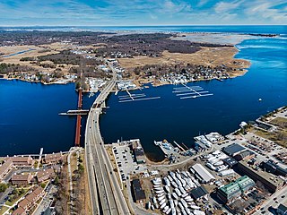
Arlington Mill Reservoir, known locally as "Arlington Pond", is a 269-acre (109 ha) impoundment located in Rockingham County in southern New Hampshire, United States, in the town of Salem. It is located along the Spicket River, a small stream that flows south to the Merrimack River in Lawrence, Massachusetts.

Mirey Brook is a 6.5-mile-long (10.5 km) stream in northern Massachusetts and southwestern New Hampshire in the United States. It is a tributary of the Ashuelot River, itself a tributary of the Connecticut River, which flows to Long Island Sound.

Tarbell Brook is a 10.1-mile-long (16.3 km) stream located in southwestern New Hampshire and northern Massachusetts in the United States. It is a tributary of the Millers River, itself a tributary of the Connecticut River, which flows to Long Island Sound.

The Nissitissit River is a 10.5-mile-long (16.9 km) river in southern New Hampshire and northern Massachusetts in the United States. It is a tributary of the Nashua River, itself a tributary of the Merrimack River, which flows to the Gulf of Maine. This river is part of the Nashua River Watershed.
Beaver Brook is a 30.7-mile-long (49.4 km) river located in New Hampshire and Massachusetts in the United States. It is a tributary of the Merrimack River, part of the Gulf of Maine watershed.

The Spicket River is a 17.7-mile-long (28.5 km) river located in New Hampshire and Massachusetts in the United States. It is a left tributary of the Merrimack River, part of the Gulf of Maine watershed. It is sometimes spelled "Spickett".
The Little River is a 12.9-mile-long (20.8 km) river in New Hampshire and Massachusetts in the United States. It is a tributary of the Merrimack River, part of the Gulf of Maine watershed.
The Back River is a 6.5-mile-long (10.5 km) river located in New Hampshire and Massachusetts in the United States. It is a tributary to the Powwow River, part of the Merrimack River watershed. Approximately 3.0 miles (4.8 km) of the river are in New Hampshire, with the remaining 3.5 miles (5.6 km) in Massachusetts.
The South Branch of the Souhegan River is a 5.8-mile-long (9.3 km) river located in northern Massachusetts and southern New Hampshire in the United States. It is a tributary of the Souhegan River, which flows to the Merrimack River and ultimately to the Gulf of Maine.

The Blackwater River is a 3.1-mile-long (5.0 km) tidal inlet in northeastern Massachusetts and southeastern New Hampshire in the United States.

Mount Garfield is a mountain located in Grafton County, New Hampshire. The mountain is part of the White Mountains. Mt. Garfield is flanked to the east by South Twin Mountain, and to the southwest along Garfield Ridge by Mount Lafayette.

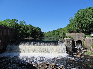
Chesterfield Gorge is a nature reserve located in Chesterfield, Massachusetts, United States. The property is owned by The Trustees of Reservations, who have administered the property since 1929.
Mount Davis is a mountain located in Coos County, New Hampshire. The mountain is located along Montalban Ridge, a series of summits extending south from Mount Washington in the White Mountains.

Massachusetts Senate's Worcester, Hampden, Hampshire and Middlesex district in the United States was one of 40 legislative districts of the Massachusetts Senate. It covered portions of Hampden, Hampshire, Middlesex, and Worcester counties. In the 2020 United States presidential election, the district was the only one in the state where incumbent President Donald Trump won. The district was last represented in the State Senate by Anne Gobi of the Democratic Party before it was abolished following 2021 redistricting.

Massachusetts Senate's Hampshire, Franklin and Worcester district in the United States is one of 40 legislative districts of the Massachusetts Senate. It covers portions of Franklin, Hampshire, and Worcester counties. Since 2019 it is represented in the State Senate by Joanne M. Comerford of the Democratic Party. Comerford is running unopposed for re-election in the 2020 Massachusetts general election.


