Jamaica Pond

Last updated
Jamaica Pond
Jamaica-pond-3.jpg
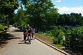
Jamaica Pond, boathouse in distance, 2005
Relief map of USA Massachusetts.png
Red pog.svg
Jamaica Pond
Location Jamaica Plain, Massachusetts
Coordinates 42°19′0″N71°7′13″W / 42.31667°N 71.12028°W / 42.31667; -71.12028
Type kettle pond
Primary outflows Muddy River
Surface area68 acres (28 ha)
Max. depth53 feet (16 m)

Jamaica Pond is a kettle lake, part of the Emerald Necklace of parks in Boston designed by Frederick Law Olmsted. The pond and park are in the Jamaica Plain neighborhood of Boston, close to the border of Brookline. It is the source of the Muddy River, which drains into the lower Charles River. USGS 2005

Contents

The pond has an area of about 68 acres (28 ha), and is 53 feet (16 m) deep at its center (MassWildlife map), making it the largest body of fresh water in Boston, and the largest natural freshwater body in the lower Charles River watershed. It is ringed by a 1.5-mile (2.4 km) walking path, and is an extremely popular destination for Bostonians for walking, fishing, rowing, and sailing. Around Halloween each year, the pond serves as the site for The Lantern Parade. Participants dress in their Halloween costumes and walk around the pond.

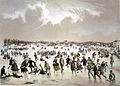
The pond once served as a reservoir for the City of Boston and the Town of West Roxbury, and it supplied ice in the winter to Boston and beyond. [1]

According to the USGS, the name Jamaica derives from an Indian name meaning "abundance of beavers". [2]

The pond's setting, Jamaica Park, was included in the Olmsted Park landscape complex that was placed on the National Register of Historic Places on December 8, 1971. [3]

History

The Jamaica Plain Ice Company employed 350 men in 1874, and harvested as much 5,000 tons of ice a day from Jamaica Pond. [4]

The pond was once the site of a popular annual winter skating carnival. In 1929, this carnival was cancelled by Mayor Curley when cracks appeared on the ice, and 50,000 skaters had to be evacuated. [5] In recent years, ice skating is no longer permitted on the pond.

Overlooking Jamaica Pond until its 2007 demolition was Pinebank Mansion, the summer home of Edward Newton Perkins.

Related Research Articles

<span class="mw-page-title-main">Charles River</span> River in Massachusetts, United States

The Charles River, sometimes called the River Charles or simply the Charles, is an 80-mile-long (129 km) river in eastern Massachusetts. It flows northeast from Hopkinton to Boston along a highly meandering route, that doubles back on itself several times and travels through 23 cities and towns before reaching the Atlantic Ocean. The indigenous Massachusett named it Quinobequin, meaning "meandering" or "meandering still water".

<span class="mw-page-title-main">Jamaica Plain</span> Neighborhood in Boston

Jamaica Plain is a neighborhood of 4.4 square miles (11 km2) in Boston, Massachusetts. Settled by Puritans seeking farmland to the south, it was originally part of Roxbury, Massachusetts. The community seceded from Roxbury during the formation of West Roxbury in 1851 and became part of Boston when West Roxbury was annexed in 1874. In the 19th century, Jamaica Plain became one of the first streetcar suburbs in America and home to a significant portion of Boston's Emerald Necklace of parks, designed by Frederick Law Olmsted.

<span class="mw-page-title-main">Boston Public Garden</span> Botanical garden in Boston, MA

The Public Garden, also known as Boston Public Garden, is a large park in the heart of Boston, Massachusetts, adjacent to Boston Common. It is a part of the Emerald Necklace system of parks and is bounded by Charles Street and Boston Common to the east, Beacon Street and Beacon Hill to the north, Arlington Street and Back Bay to the west, and Boylston Street to the south. The Public Garden was the first public botanical garden in America.

<span class="mw-page-title-main">Emerald Necklace</span> Chain of parks in Boston, Massachusetts

The Emerald Necklace consists of a 1,100-acre chain of parks linked by parkways and waterways in Boston and Brookline, Massachusetts. It was designed by landscape architect Frederick Law Olmsted, and gets its name from the way the planned chain appears to hang from the "neck" of the Boston peninsula. In 1989, the Emerald Necklace was designated as a Boston Landmark by the Boston Landmarks Commission.

<span class="mw-page-title-main">Arnold Arboretum</span> Botanical garden in Boston, Massachusetts

The Arnold Arboretum of Harvard University is a botanical research institution and free public park, located in the Jamaica Plain and Roslindale neighborhoods of Boston, Massachusetts. Established in 1872, it is the oldest public arboretum in North America. The landscape was designed by Charles Sprague Sargent and Frederick Law Olmsted and is the second largest "link" in the Emerald Necklace. The Arnold Arboretum's collection of temperate trees, shrubs, and vines has an emphasis on the plants of the eastern United States and eastern Asia, where arboretum staff and colleagues are sourcing new material on plant collecting expeditions. The arboretum supports research in its landscape and in its Weld Hill Research Building.

<span class="mw-page-title-main">Olmsted Park</span>

Olmsted Park is a linear park in Boston and Brookline, Massachusetts, and a part of Boston's Emerald Necklace of connected parks and parkways. Originally named Leverett Park, in 1900 it was renamed to honor its designer, Frederick Law Olmsted.

<span class="mw-page-title-main">Charles River Reservation</span>

The Charles River Reservation is a 17-mile-long (27 km) urban preserve and public recreation area located along the banks of the Charles River in Boston, Cambridge, Watertown, and Newton, Massachusetts. The reservation is managed by the Massachusetts Department of Conservation and Recreation.

<span class="mw-page-title-main">Larz Anderson Park</span> United States historic place

Larz Anderson Park is a wooded, landscaped, and waterscaped 64-acre (26 ha) parkland in Brookline, Massachusetts that is listed on the National Register of Historic Places. The southwest corner of the park is in Boston. The park contains playing fields, picnic areas, gardens, waterways, an ice skating rink, and two sites of special interest:

<span class="mw-page-title-main">Franklin Park (Boston)</span> Protected area in Massachusetts

Franklin Park, a partially wooded 527-acre (2.13 km2) parkland in the Jamaica Plain, Roxbury, and Dorchester neighborhoods of Boston, Massachusetts, is maintained by the City of Boston Parks and Recreation Department. It is Boston's biggest park and the site of Franklin Park Zoo. It was designated a Boston Landmark by the Boston Landmarks Commission in August 1980.

<span class="mw-page-title-main">Jamaicaway</span> Parkway in the Jamaica Plain neighborhood of Boston

Jamaicaway is a four-lane, undivided parkway in the Jamaica Plain neighborhood of Boston, Massachusetts, United States, near the border of Brookline.

<span class="mw-page-title-main">Arborway</span>

Arborway consists of a four-lane, divided parkway and a two lane residential street in the Jamaica Plain neighborhood of Boston, Massachusetts, United States. It was designed by Frederick Law Olmsted in the 1890s as the south most carriage road in a series of parkways connecting parks from Boston Common in downtown Boston to Franklin Park in Roxbury. This park system has since become known as the Emerald Necklace of Boston.

<span class="mw-page-title-main">Fenway (parkway)</span> Road in Boston, United States

Fenway, commonly referred to as The Fenway, is a mostly one-way, one- to three-lane parkway that runs along the southern and eastern edges of the Back Bay Fens in the Fenway–Kenmore neighborhood of Boston, in the east-central part of the U.S. state of Massachusetts. As part of the Emerald Necklace park system mainly designed by Frederick Law Olmsted in the late 19th century, the Fenway, along with the Back Bay Fens and Park Drive, connects the Commonwealth Avenue Mall to the Riverway. For its entire length, the parkway travels along the Muddy River and is part of the Metropolitan Park System of Greater Boston. Like others in the park system, it is maintained by the Massachusetts Department of Conservation and Recreation.

Pinebank Mansion was a Queen Anne style house sited on a hill overlooking Jamaica Pond in Boston, Massachusetts. Built in 1868 by John Hubbard Sturgis, it was the only mansion retained by Frederick Law Olmsted in his plans for the Emerald Necklace park system. It was the only original structure remaining in the park system at the time of its demolition in 2007.

<span class="mw-page-title-main">Linear park</span> Long strip of naturally occurring land for recreation

A linear park is a type of park that is significantly longer than it is wide. These linear parks are strips of public land running along canals, rivers, streams, defensive walls, electrical lines, or highways and shorelines. Examples of linear parks include everything from wildlife corridors to riverways to trails, capturing the broadest sense of the word. Other examples include rail trails, which are disused railroad beds converted for recreational use by removing existing structures. Commonly, these linear parks result from the public and private sectors acting on the dense urban need for open green space. Linear parks stretch through urban areas, coming through as a solution for the lack of space and need for urban greenery. They also effectively connect different neighborhoods in dense urban areas as a result, and create places that are ideal for activities such as jogging or walking. Linear parks may also be categorized as greenways. In Australia, a linear park along the coast is known as a foreshoreway. When being designed, linear parks appear unique as they are planned around the public's opinion of how the space will affect them.

<span class="mw-page-title-main">Lake Cochituate</span> Reservoir in Middlesex County, Massachusetts

Lake Cochituate is a body of water in Natick, Wayland, and Framingham, Massachusetts, United States. Originally a reservoir serving Boston, it no longer serves that function, and is now a local recreational resource and home to Cochituate State Park.

<span class="mw-page-title-main">Muddy River (Massachusetts)</span>

The Muddy River is a series of brooks and ponds that runs through sections of Boston's Emerald Necklace, including along the south boundary of Brookline, Massachusetts. The river, which is narrower than most waterways designated as rivers in the United States, is a protected public recreation area surrounded by parks and hiking trails, managed by the Massachusetts Department of Conservation and Recreation.

<span class="mw-page-title-main">Dorchesterway</span>

The Dorchesterway was a parkway planned by 19th century landscape designer Frederick Law Olmsted to be a continuation of the Emerald Necklace park network in Boston, Massachusetts. This plan, however, was never implemented.

<span class="mw-page-title-main">Southwest Corridor Park</span>

Southwest Corridor Park is a linear urban park in Boston, Massachusetts, part of the Metropolitan Park System of Greater Boston and managed by the Massachusetts Department of Conservation and Recreation (DCR). It extends from the South End and Back Bay neighborhoods south for almost five miles (8 km), ending in the Forest Hills section of Jamaica Plain in what was originally planned to be the alignment for Interstate 95 to Boston. It closely follows the routes of regional Amtrak and Commuter Rail lines and the Massachusetts Bay Transportation Authority (MBTA) Orange Line rapid transit rail line, from its Back Bay Station to its terminus at Forest Hills station. It features tennis courts, basketball courts, playgrounds, and walking, jogging, and biking paths.

<span class="mw-page-title-main">Stony Brook (Charles River tributary, Boston)</span> Buried river in Boston, Massachusetts

Stony Brook is a 8.5-mile (13.7 km)-long subterranean river in Boston. The largest tributary stream of the lower Charles River, it runs mostly through conduits. Stony Brook originates at Turtle Pond in the Stony Brook Reservation and flows through Hyde Park, Roslindale, Jamaica Plain, and Roxbury. It empties into the Charles River Basin just upstream of the Harvard Bridge. Stony Brook is fed by four tributaries, all of which are partially or entirely in conduits as well.

Spontaneous Celebrations refers to both a building in Jamaica Plain, Massachusetts, United States which acts as an arts and education center, and to a community group which is based there. The mission of the group is to create a cultural life through the arts, and especially through seasonal celebrations in Jamaica Plain and Roxbury, Massachusetts and education. Its classes emphasize dance, stiltwalking, trapeze, and other circus arts.

References