Jamaica Plain is a neighborhood of 4.4 square miles (11 km2) in Boston, Massachusetts, United States. Settled by Puritans seeking farmland to the south, it was originally part of Roxbury. The community seceded from Roxbury during the formation of West Roxbury in 1851 and became part of Boston when West Roxbury was annexed in 1874. In the 19th century, Jamaica Plain became one of the first streetcar suburbs in America and home to a significant portion of Boston's Emerald Necklace of parks, designed by Frederick Law Olmsted.

The Back Bay Fens, often called The Fens, is a parkland and urban wild in Boston, Massachusetts, United States. It was established in 1879. Designed by Frederick Law Olmsted to serve as a link in the Emerald Necklace park system, the Fens gives its name to the Fenway-Kenmore neighborhood.

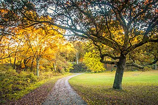
The Emerald Necklace consists of a 1,100-acre chain of parks linked by parkways and waterways in Boston and Brookline, Massachusetts. It was designed by landscape architect Frederick Law Olmsted, and gets its name from the way the planned chain appears to hang from the "neck" of the Boston peninsula. In 1989, the Emerald Necklace was designated as a Boston Landmark by the Boston Landmarks Commission.

Forest Hills station is an intermodal transfer station in Boston, Massachusetts. It serves the MBTA rapid transit Orange Line and three MBTA Commuter Rail lines and is a major terminus for MBTA bus routes. It is located in Forest Hills, in the southern part of the Jamaica Plain neighborhood. Most Providence/Stoughton Line and Franklin/Foxboro Line trains, and all Amtrak Northeast Corridor trains, pass through the station without stopping. Forest Hills station is fully accessible on all modes.

Jamaica Pond is a kettle lake, part of the Emerald Necklace of parks in Boston designed by Frederick Law Olmsted. The pond and park are in the Jamaica Plain neighborhood of Boston, close to the border of Brookline. It is the source of the Muddy River, which drains into the lower Charles River.USGS 2005

Olmsted Park is a linear park in Boston and Brookline, Massachusetts, and a part of Boston's Emerald Necklace of connected parks and parkways. Originally named Leverett Park, in 1900 it was renamed to honor its designer, Frederick Law Olmsted.
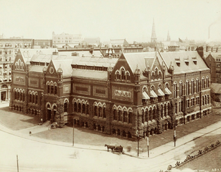
John Hubbard Sturgis was an American architect and builder who was active in the New England area during the late 19th century. His most prominent works included Codman House, Lincoln, Massachusetts, and the personal residence of Isabella Stewart Gardner. Later in his architectural career he founded, along with Charles Brigham, Sturgis and Brigham. The firm lasted nearly two decades in New England and received many notable commissions such as the first Boston Museum of Fine Arts building, located in Copley Square.

Boston Children's Museum is a children's museum in Boston, Massachusetts, dedicated to the education of children. Located on Children's Wharf along the Fort Point Channel, Boston Children's Museum is the second oldest children's museum in the United States. It contains many activities meant to both amuse and educate young children.

The Boston Planning & Development Agency (BPDA), formerly the Boston Redevelopment Authority (BRA), is a Massachusetts public agency that serves as the municipal planning and development agency for Boston, working on both housing and commercial developments.

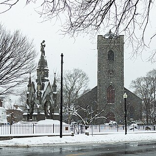
Forest Hills is a part of the Jamaica Plain neighborhood of Boston, Massachusetts, United States. Forest Hills is characterized by hilly terrain and wooded areas within and adjacent to its borders. In general, the area slopes upward from Hyde Park Ave and downward from Walk Hill Street.
Franklin Park, a partially wooded 527-acre (2.13 km2) parkland bordered by the Jamaica Plain, Roxbury, and Dorchester neighborhoods of Boston, Massachusetts, is maintained by the City of Boston Parks and Recreation Department. It is Boston's biggest park and the site of Franklin Park Zoo. It was designated a Boston Landmark by the Boston Landmarks Commission in August 1980.

Jamaicaway is a four-lane, undivided parkway in the Jamaica Plain neighborhood of Boston, Massachusetts, United States, near the border of Brookline.

Arborway consists of a four-lane, divided parkway and a two-lane residential street in the Jamaica Plain neighborhood of Boston, Massachusetts, United States. It was designed by Frederick Law Olmsted in the 1890s as the southern-most carriage road in a series of parkways connecting parks from Boston Common in downtown Boston to Franklin Park in Roxbury. This park system has since become known as the Emerald Necklace.

Fenway, commonly referred to as The Fenway, is a mostly one-way, one- to three-lane parkway that runs along the southern and eastern edges of the Back Bay Fens in the Fenway–Kenmore neighborhood of Boston, in the east-central part of the U.S. state of Massachusetts. As part of the Emerald Necklace park system mainly designed by Frederick Law Olmsted in the late 19th century, the Fenway, along with the Back Bay Fens and Park Drive, connects the Commonwealth Avenue Mall to the Riverway. For its entire length, the parkway travels along the Muddy River and is part of the Metropolitan Park System of Greater Boston. Like others in the park system, it is maintained by the Massachusetts Department of Conservation and Recreation.
The Hancock Manor was a house located at 30 Beacon Street on Beacon Hill, Boston, Massachusetts. It stood near the southwest corner of what are today the grounds of the Massachusetts State House. It was the home of United States Founding Father John Hancock.

The Muddy River is a series of brooks and ponds that runs through sections of Boston's Emerald Necklace, including along the south boundary of Brookline, Massachusetts. The river, which is narrower than most waterways designated as rivers in the United States, is a protected public recreation area surrounded by parks and hiking trails, managed by the Massachusetts Department of Conservation and Recreation.

The Dorchesterway was a parkway planned by 19th century landscape designer Frederick Law Olmsted to be a continuation of the Emerald Necklace park network in Boston, Massachusetts. This plan, however, was never implemented.

The Lewis Cabot Estate was a historic estate at Warren and Heath Streets in Brookline, Massachusetts. The estate, developed in 1894, was one of few surviving turn-of-the-century properties of the Boston Brahmin Cabot family, and a prominent local example of Jacobethan architecture with landscaping by Frederick Law Olmsted. The remnant portion of the estate was listed on the National Register of Historic Places in 1985; the main house has since been demolished.

Southwest Corridor Park is a linear urban park in Boston, Massachusetts, part of the Metropolitan Park System of Greater Boston and managed by the Massachusetts Department of Conservation and Recreation (DCR). It extends from the South End and Back Bay neighborhoods south for almost five miles (8 km), ending in the Forest Hills section of Jamaica Plain in what was originally planned to be the alignment for Interstate 95 to Boston. It closely follows the routes of regional Amtrak and Commuter Rail lines and the Massachusetts Bay Transportation Authority (MBTA) Orange Line rapid transit rail line, from its Back Bay Station to its terminus at Forest Hills station. It features tennis courts, basketball courts, playgrounds, and walking, jogging, and biking paths.

William J. Devine Memorial Golf Course, colloquially referred to as and contained within Franklin Park, is a municipal golf course in the Jamaica Plain neighborhood of Boston, Massachusetts, bordered by the neighborhoods of Dorchester and Roxbury. Established on October 26, 1896, it is the second oldest public golf course in the United States. The course is named after William J. Devine, former Commissioner of Boston's Parks and Recreation Department.

