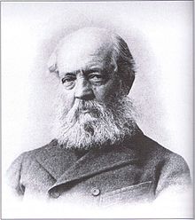
The Dorchesterway was a parkway planned by 19th century landscape designer Frederick Law Olmsted to be a continuation of the Emerald Necklace park network in Boston, Massachusetts. This plan, however, was never implemented.
The Dorchesterway was a parkway planned by 19th century landscape designer Frederick Law Olmsted to be a continuation of the Emerald Necklace park network in Boston, Massachusetts. This plan, however, was never implemented.
The Emerald Necklace, as extant today, has a sort of "L" shape. It starts at the Boston Common near Downtown Crossing and extends out to the Arnold Arboretum (which starts in Forest Hills but has portions in Roslindale near the West Roxbury border). It then changes direction back inwards as the Arboretum connects via the Arborway to Franklin Park.
Olmsted wanted the Emerald Necklace to continue via the Dorchesterway to the shore of Boston Harbor's Dorchester Bay and thus form a "U" shape. He intended Columbia Road in Dorchester and the Strandway (the southern roadway of which is now known as William J. Day Boulevard) in South Boston to connect South Boston's Marine Park and Pleasure Bay to the network of natural-looking green spaces he had designed.
However:
...conditions of Columbia Road when the parks system was being established [...] precluded this vision from becoming a reality. When Columbia Road was formally designed in the late 1800s, there was already a relatively high density of buildings. The road had street rails that were used by a streetcar trolley connecting Uphams Corner and Franklin Park. There was a grass strip in the center and roads on either side, one for commercial traffic and the other for pleasure traffic. As a result, Columbia Road failed to serve the purposes of either the businesses or the pleasure travelers well, and there was not enough room for what Olmsted considered a proper parkway. [1]
Some trees and planters were added on Columbia Boulevard in the late 1980s. [2]
In the last decade,[ when? ] the Boston Department of Parks and Recreation planted and has been maintaining trees, grass, planters and other vegetation along one section of Columbia Road.[ citation needed ]
But despite the recent greening of parts of Columbia Road, natural elements in this area remain meager due to the dense neighborhood development. For this reason, the corridor is not a parkway along the lines of other sections of the Emerald Necklace in nearby Jamaica Plain, and Columbia Road is not considered part of the Emerald Necklace. [1]
The Boston bid for the 2024 Summer Olympics proposed private funding to remove the median of Columbia Road and install trees and separated bike lanes, [2] but the bid was withdrawn in July, 2015.

It is possible that some incarnation of a Dorchesterway connecting the Emerald Necklace to the seashore might someday come into being. Members of the Emerald Necklace Conservancy, [3] expressing a long-term vision for the Boston Parks system, have proposed using Columbia Road to enhance the connections between Franklin Park, Marine Park and Pleasure Bay via Columbia Road. Linking to South Boston has also been discussed. According to Simone Auster, former director of the Emerald Necklace Conservancy:
...a vision for a "completed" Emerald Necklace has not yet been flushed out by the Conservancy or other groups, but the idea of the system connecting to Pleasure Bay and Castle Island via Columbia Road and eventually back to Back Bay Fens or Boston Common resonates with many Bostonians. [1]
A representative of the Boston Department of Parks and Recreation said:
It should be a priority to reconnect Columbia Road and give it a boulevard feeling. The quality of space, the mature trees and grass—they should be as much a part of making this area feel special as on the opposite side. [1]
In 2004, a Boston Redevelopment Authority strategic plan for the improvement of Roxbury recommended major street reconstruction, including trees and antique-style lamp posts, to give Columbia Road the character of a pleasant boulevard. [4]

The Back Bay Fens, often called The Fens, is a parkland and urban wild in Boston, Massachusetts, in the United States. It was established in 1879. Designed by Frederick Law Olmsted to serve as a link in the Emerald Necklace park system, the Fens gives its name to the Fenway-Kenmore neighborhood.

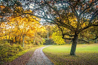
The Emerald Necklace consists of a 1,100-acre chain of parks linked by parkways and waterways in Boston and Brookline, Massachusetts. It was designed by landscape architect Frederick Law Olmsted, and gets its name from the way the planned chain appears to hang from the "neck" of the Boston peninsula. In 1989, the Emerald Necklace was designated as a Boston Landmark by the Boston Landmarks Commission.

Forest Hills station is an intermodal transfer station in Boston, Massachusetts. It serves the MBTA rapid transit Orange Line and three MBTA Commuter Rail lines and is a major terminus for MBTA bus routes. It is located in Forest Hills, in the southern part of the Jamaica Plain neighborhood. Most Providence/Stoughton Line and Franklin Line trains, and all Amtrak Northeast Corridor trains, pass through the station without stopping.

The Arnold Arboretum of Harvard University is a botanical research institution and free public park, located in the Jamaica Plain and Roslindale neighborhoods of Boston, Massachusetts. Established in 1872, it is the oldest public arboretum in North America. The landscape was designed by Charles Sprague Sargent and Frederick Law Olmsted and is the second largest "link" in the Emerald Necklace. The Arnold Arboretum's collection of temperate trees, shrubs, and vines has an emphasis on the plants of the eastern United States and eastern Asia, where arboretum staff and colleagues are sourcing new material on plant collecting expeditions. The arboretum supports research in its landscape and in its Weld Hill Research Building.

Olmsted Park is a linear park in Boston and Brookline, Massachusetts, and a part of Boston's Emerald Necklace of connected parks and parkways. Originally named Leverett Park, in 1900 it was renamed to honor its designer, Frederick Law Olmsted.

Boston's diverse neighborhoods serve as a political and cultural organizing mechanism. The City of Boston's Office of Neighborhood Services has designated 23 Neighborhoods in the city:
Franklin Park, a partially wooded 527-acre (2.13 km2) parkland in the Jamaica Plain, Roxbury, and Dorchester neighborhoods of Boston, Massachusetts, is maintained by the City of Boston Parks and Recreation Department. It is Boston's biggest park and the site of Franklin Park Zoo. It was designated a Boston Landmark by the Boston Landmarks Commission in August 1980.

Jamaicaway is a four-lane, undivided parkway in the Jamaica Plain neighborhood of Boston, Massachusetts, United States, near the border of Brookline.

Arborway consists of a four-lane, divided parkway and a two lane residential street in the Jamaica Plain neighborhood of Boston, Massachusetts, United States. It was designed by Frederick Law Olmsted in the 1890s as the south most carriage road in a series of parkways connecting parks from Boston Common in downtown Boston to Franklin Park in Roxbury. This park system has since become known as the Emerald Necklace of Boston.

Riverway, also referred to as "the Riverway," is a parkway in Boston, Massachusetts. The parkway is a link in the Emerald Necklace system of parks and parkways designed by Frederick Law Olmsted in the 1890s. Starting at the Landmark Center end of the Back Bay Fens, the parkway follows the path of the Muddy River south to Olmsted Park across a stone bridge over Route 9 near Brookline Village. The road and its associated park form Boston's western border with neighboring Brookline and are popular with nearby local residents in both municipalities.

Fenway, commonly referred to as The Fenway, is a mostly one-way, one- to three-lane parkway that runs along the southern and eastern edges of the Back Bay Fens in the Fenway–Kenmore neighborhood of Boston, in the east-central part of the U.S. state of Massachusetts. As part of the Emerald Necklace park system mainly designed by Frederick Law Olmsted in the late 19th century, the Fenway, along with the Back Bay Fens and Park Drive, connects the Commonwealth Avenue Mall to the Riverway. For its entire length, the parkway travels along the Muddy River and is part of the Metropolitan Park System of Greater Boston. Like others in the park system, it is maintained by the Massachusetts Department of Conservation and Recreation.

A linear park is a type of park that is significantly longer than it is wide. These linear parks are strips of public land running along canals, rivers, streams, defensive walls, electrical lines, or highways and shorelines. Examples of linear parks include everything from wildlife corridors to riverways to trails, capturing the broadest sense of the word. Other examples include rail trails, which are disused railroad beds converted for recreational use by removing existing structures. Commonly, these linear parks result from the public and private sectors acting on the dense urban need for open green space. Linear parks stretch through urban areas, coming through as a solution for the lack of space and need for urban greenery. They also effectively connect different neighborhoods in dense urban areas as a result, and create places that are ideal for activities such as jogging or walking. Linear parks may also be categorized as greenways. In Australia, a linear park along the coast is known as a foreshoreway. When being designed, linear parks appear unique as they are planned around the public's opinion of how the space will affect them.

The Muddy River is a series of brooks and ponds that runs through sections of Boston's Emerald Necklace, including along the south boundary of Brookline, Massachusetts. The river, which is narrower than most waterways designated as rivers in the United States, is a protected public recreation area surrounded by parks and hiking trails, managed by the Massachusetts Department of Conservation and Recreation.

Morton Street is a street in southern Boston, Massachusetts, United States. It extends from the southeastern end of the Arborway in Jamaica Plain to Washington Street in the Lower Mills Village of Dorchester. Most of the road is a connecting parkway, signed as part of Massachusetts Route 203, that provides access to Boston's Emerald Necklace of parks. That portion of the road was listed on the National Register of Historic Places in 2005.

The parkway system of Louisville, Kentucky, also known as the Olmsted Park System, was designed by the firm of preeminent 19th century landscape architect Frederick Law Olmsted. The 26-mile (42 km) system was built from the early 1890s through the 1930s, and initially owned by a state-level parks commission, which passed control to the city of Louisville in 1942.

Hammond Pond Parkway is a historic parkway in Chestnut Hill, Massachusetts. The road, built in 1932, extends 2 miles (3.2 km) from Hobart Road in Newton to Horace James Circle in Brookline, where it joins the West Roxbury Parkway. It was designed by Charles Eliot and the Olmsted Brothers to provide a parkway setting that provided access from Brookline, Newton, and the western portions of Boston to the southern parks of the Emerald Necklace. The parkway was listed on the National Register of Historic Places in 2004.

The Old Harbor Reservation Parkways are three historic roads in the Old Harbor area of Boston. They are part of the Boston parkway system designed by Frederick Law Olmsted. They include

William J. Day Boulevard, or Day Boulevard, is a coastal parkway in Boston, Massachusetts. Beginning at Morrissey Boulevard and Kosciuszko Circle at the northern extent of the Dorchester section of the city, it travels in a gently curving northeasterly direction 2.6 miles (4.2 km) through South Boston along beaches around the west and north shore of Dorchester Bay. It was named for William J. Day.

Park Drive is a mostly one-way, two-lane parkway in the Fenway-Kenmore neighborhood of Boston that runs along the northern and western edges of the Back Bay Fens before ending at Mountfort Street. As part of the Emerald Necklace park system mainly designed by Frederick Law Olmsted in the late 19th century, Park Drive, along with the Back Bay Fens and the Fenway, connects the Commonwealth Avenue Mall and Boylston Street to Beacon Street and the Riverway. For a portion of its length, the parkway runs along the Muddy River and is part of the Metropolitan Park System of Greater Boston's Muddy River Reservation. Like others in the park system, it is maintained by the Massachusetts Department of Conservation and Recreation.

William J. Devine Memorial Golf Course, colloquially referred to as and contained within Franklin Park, is a municipal golf course in the Jamaica Plain neighborhood of Boston, Massachusetts, bordered by the neighborhoods of Dorchester and Roxbury. Established on October 26, 1896, it is the second oldest public golf course in the United States. The course is named after William J. Devine, former Commissioner of Boston's Parks and Recreation Department.

