
Brookline is a town in Norfolk County, Massachusetts, United States, and part of the Boston metropolitan area. An exclave of Norfolk County, Brookline borders six of Boston's neighborhoods: Brighton, Allston, Fenway–Kenmore, Mission Hill, Jamaica Plain, and West Roxbury. The city of Newton borders Brookline to the west. It is known as the birthplace of John F. Kennedy.

The Back Bay Fens, often called The Fens, is a parkland and urban wild in Boston, Massachusetts, United States. It was established in 1879. Designed by Frederick Law Olmsted to serve as a link in the Emerald Necklace park system, the Fens gives its name to the Fenway-Kenmore neighborhood.
Fenway–Kenmore is an officially recognized neighborhood of Boston, Massachusetts. It is considered one neighborhood for administrative purposes, but it is composed of numerous distinct sections that are almost always referred to as "Fenway", "the Fenway", "Kenmore Square", or "Kenmore". Furthermore, the Fenway neighborhood is divided into two sub-neighborhoods commonly referred to as East Fenway/Symphony and West Fenway.

Longwood station is a light rail station on the MBTA Green Line D branch, located on Chapel Street in Brookline, Massachusetts, on the border with Boston, just north of Longwood Avenue. It serves the Longwood Medical Area, the Colleges of the Fenway, and residential areas of Brookline. The station opened with the rest of the line on July 4, 1959. After renovation work completed in 2009, Longwood station is accessible from both Chapel Street and Riverway Park.

Chestnut Hill is a wealthy New England village located six miles (10 km) west of downtown Boston, Massachusetts, United States. It is best known for being home to Boston College and a section of the Boston Marathon route. Like all Massachusetts villages, Chestnut Hill is not an incorporated municipal entity. It is located partially in Brookline in Norfolk County; partially in the city of Boston in Suffolk County, and partially in the city of Newton in Middlesex County. Chestnut Hill's borders are defined by the 02467 ZIP Code. The name refers to several small hills that overlook the 135-acre Chestnut Hill Reservoir rather than one particular hill.

The Emerald Necklace consists of a 1,100-acre chain of parks linked by parkways and waterways in Boston and Brookline, Massachusetts. It was designed by landscape architect Frederick Law Olmsted, and gets its name from the way the planned chain appears to hang from the "neck" of the Boston peninsula. In 1989, the Emerald Necklace was designated as a Boston Landmark by the Boston Landmarks Commission.

Olmsted Park is a linear park in Boston and Brookline, Massachusetts, and a part of Boston's Emerald Necklace of connected parks and parkways. Originally named Leverett Park, in 1900 it was renamed to honor its designer, Frederick Law Olmsted.

Jamaicaway is a four-lane, undivided parkway in the Jamaica Plain neighborhood of Boston, Massachusetts, United States, near the border of Brookline.

Riverway, also referred to as "the Riverway," is a parkway in Boston, Massachusetts. The parkway is a link in the Emerald Necklace system of parks and parkways designed by Frederick Law Olmsted in the 1890s. Starting at the Landmark Center end of the Back Bay Fens, the parkway follows the path of the Muddy River south to Olmsted Park across a stone bridge over Route 9 near Brookline Village. The road and its associated park form Boston's western border with neighboring Brookline and are popular with nearby local residents in both municipalities.

Fenway, commonly referred to as The Fenway, is a mostly one-way, one- to three-lane parkway that runs along the southern and eastern edges of the Back Bay Fens in the Fenway–Kenmore neighborhood of Boston, in the east-central part of the U.S. state of Massachusetts. As part of the Emerald Necklace park system mainly designed by Frederick Law Olmsted in the late 19th century, the Fenway, along with the Back Bay Fens and Park Drive, connects the Commonwealth Avenue Mall to the Riverway. For its entire length, the parkway travels along the Muddy River and is part of the Metropolitan Park System of Greater Boston. Like others in the park system, it is maintained by the Massachusetts Department of Conservation and Recreation.

The Landmark Center or 401 Park Building in Boston, Massachusetts is a commercial center situated in a limestone and brick art deco building built in 1928 for Sears, Roebuck and Company. It features a 200-foot-tall (61 m) tower and, as Sears Roebuck and Company Mail Order Store, it is listed on the National Register of Historic Places and designated as a Boston Landmark in 1989.

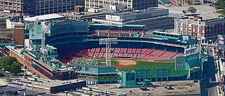
Boylston Street is a major east–west thoroughfare in the city of Boston, Massachusetts and its western suburbs. The street begins in Boston's Chinatown neighborhood, forms the southern border of the Boston Public Garden and Boston Common, runs through Back Bay and Boston's Fenway neighborhood, merges into Brookline Ave and then Washington Street, emerging again contiguous with Route 9 out to where it crosses Route 128, after which it becomes Worcester Street.

The Muddy River is a series of brooks and ponds that runs through sections of Boston's Emerald Necklace, including along the south boundary of Brookline, Massachusetts. The river, which is narrower than most waterways designated as rivers in the United States, is a protected public recreation area surrounded by parks and hiking trails, managed by the Massachusetts Department of Conservation and Recreation.

The Dorchesterway was a parkway planned by 19th century landscape designer Frederick Law Olmsted to be a continuation of the Emerald Necklace park network in Boston, Massachusetts. This plan, however, was never implemented.
The Fenway-Boylston Street District is a historic district encompassing a series of predominantly residential buildings lining The Fenway in the Fenway–Kenmore of Boston, Massachusetts. Developed beginning in the 1890s, the area is emblematic of Boston's upper-class residential development of the period, with architect-designed houses built for some of the city's leading families. The district was listed on the National Register of Historic Places in 1984.

Brookline Avenue is a principal urban artery in the city of Boston, Massachusetts. It runs from Kenmore Square in the Fenway-Kenmore neighborhood, forming a 1.5-mile straight line to its other terminus at Washington Street in the Brookline Village neighborhood of Brookline, Massachusetts. The Landmark Center, Fenway Park, Emmanuel College, Longwood Medical and Academic Area and Kenmore Square are sites along its length.

Hammond Pond Parkway is a historic parkway in Chestnut Hill, Massachusetts. The road, built in 1932, extends 2 miles (3.2 km) from Hobart Road in Newton to Horace James Circle in Brookline, where it joins the West Roxbury Parkway. It was designed by Charles Eliot and the Olmsted Brothers to provide a parkway setting that provided access from Brookline, Newton, and the western portions of Boston to the southern parks of the Emerald Necklace. The parkway was listed on the National Register of Historic Places in 2004.
Stony Brook is a 8.5-mile (13.7 km)-long subterranean river in Boston. The largest tributary stream of the lower Charles River, it runs mostly through conduits. Stony Brook originates at Turtle Pond in the Stony Brook Reservation and flows through Hyde Park, Roslindale, Jamaica Plain, and Roxbury. It empties into the Charles River Basin just upstream of the Harvard Bridge. Stony Brook is fed by four tributaries, all of which are partially or entirely in conduits as well.

The Boylston Street subway is a light rail tunnel which lies primarily under Boylston Street in Boston, Massachusetts. In operation since 1914, it now carries all four branches of the MBTA Green Line from Kenmore Square under the Back Bay into downtown Boston, where it joins with the older Tremont Street subway. The tunnel originally ended just east of Kenmore Square; it was extended under the square to new portals at Blandford Street and St. Mary's Street in 1932.

The Ipswich Street line was a streetcar line in Boston and Brookline, Massachusetts. The line ran on Boylston Street and Ipswich Street in the Fenway–Kenmore neighborhood, and on Brookline Avenue through what is now the Longwood Medical Area to Brookline Village.


