Soldiers Field Road

Last updated

Soldiers Field Road
Soldiers Field Road.png
Soldiers Field Road highlighted in red
Maintained by Massachusetts DCR
Length4.3 mi (6.9 km) [1] [2]
Coordinates 42°22′22″N71°7′45″W / 42.37278°N 71.12917°W / 42.37278; -71.12917
West endUS 20.svg US 20 in Brighton
Major
junctions
I-90.svg I-90  / Mass Pike in Allston
East end Storrow Drive in Fenway–Kenmore

Soldiers Field Road is a major crosstown parkway in Boston, Massachusetts, running west to east from U.S. Route 20 in the northwest corner of Brighton to the Boston University Bridge. [1] It follows the course of the Charles River and also passes by the campuses of Harvard University and Boston University. The road is named for the area south of the road on a bend in the Charles River. On June 5, 1890, Henry Lee Higginson presented Harvard College a gift of 31 acres (130,000 m2) of land, which he called Soldiers Field, given in honor of his friends who died in the Civil War: James Savage, Jr., Charles Russell Lowell, Edward Barry Dalton, Stephen George Perkins, James Jackson Lowell, and Robert Gould Shaw. This land later became the home of Harvard Crimson athletics.

Contents

Although considered a "major crosstown street", the road has a 10-foot (3.04 m) height restriction due to viaduct crossings. In 2013 one of these crossings was the site of a serious bus crash. [3] Speed limits range from 30 to 40 miles per hour (48 to 64 km/h) on various segments of the road.

Route description

Looking eastbound in the Allston neighborhood Soldiers Field Road eastbound, Allston MA.jpg
Looking eastbound in the Allston neighborhood

Soldiers Field Road is one link in a nearly nine-mile continuous roadway along the southern bank of the Charles River, continuing to the east as Storrow Drive, David G. Mugar Way, and Embankment Road, and to the west as Nonantum Road.

The road begins at the intersection with North Beacon Street and Nonantum Road. For the first 0.4 miles (0.64 km) there is no median division, and there is at-grade access to local businesses. The road then passes under the Arsenal Street Bridge access roads. The road then passes south of the Northeastern University Boathouse and Charles River Community Garden, which it provides access to on the westbound side of the road. One half-mile east of the Arsenal Street Bridge there is a footbridge crossing over the road between Telford Street and the Artesani Playground, which is part of Christian Herter Park. There is access to and from the park at an at-grade intersection with Everett Street. As the road turns north it passes the WBZ headquarters and Smith Playground before following the perimeter of the Soldiers Field athletic facility, home to Harvard Athletics. The closest portions of the facility to the road are the field hockey field, tennis courts and practice fields. At the top of the bend in the Charles River the road intersects with the Eliot Bridge, which heads west from the northern end of the bend, providing access to Greenough Boulevard, Mount Auburn Hospital and Mount Auburn Cemetery in neighboring Cambridge. As the road and the Charles bends southward, it passes Jordan Field (the soccer field), the Palmer Dixon Center, Dillon Field House, Lavietes Pavilion and Blodgett Pool to the southwest and the Newell Boathouse to the northeast of the road.

Soldiers Field Road then passes under North Harvard Street as it joins Anderson Memorial Bridge. It continues eastward past the Harvard Business School campus, where the river makes another bend at the Weeks Footbridge. The road then passes under the approach to the Western Avenue Bridge, where traffic passes one way from Cambridge into the Allston neighborhood. Just 300 yards (0.17 mi) later, the road passes under the approach road between Cambridge Street and the River Street Bridge, which returns traffic from Allston to Cambridge. To the south of this bridge the road passes to the north and east of rail yards before paralleling the Massachusetts Turnpike from just east of the Allston tollbooths and past Boston University until just west of the Grand Junction Railroad Bridge. At this point the road and river split from the Mass Pike and pass under the Boston University Bridge, at which point Soldiers Field Road becomes Storrow Drive.

History

Portions of the current alignment of Soldiers Field Road were originally part of the Charles River Speedway, which was built in 1899. The speedway ran from near Market Street and the Arsenal Street bridge, to the site of the Eliot Bridge (which wasn't built until 1950). [4] The only surviving building relating to the speedway is the Charles River Reservation (Speedway)-Upper Basin Headquarters, which formerly housed administrative and logistical personnel for the Metropolitan District Commission.

The portion of Soldiers Field Road nearest the Boston University Bridge is expected to be rebuilt as part of a major project to straighten the Turnpike.

Major intersections

The entire route is in Boston, Suffolk County. All exits are unnumbered.

Locationmi [2] kmDestinationsNotes
Brighton 0.00.0US 20.svg US 20 (Beacon Street) / Nonantum Road west Watertown Square, Newton, Brighton Center Traffic circle
Allston 0.71.1Western Avenue / Arsenal Street Brighton Center, Watertown Interchange
2.03.2MA Route 2.svgUS 3.svg Route 2  / US 3  / Fresh Pond Parkway  Arlington Partial interchange
2.54.0Harvard Street Harvard Square, Allston, Cambridge Interchange
3.15.0I-90.svg I-90  / Mass Pike  / Western Avenue / Cambridge Street Central Square, Cambridge Interchange; exit 131 on I-90 / Mass Pike
Fenway–Kenmore 4.16.6University Road Brookline Interchange; eastbound exit and entrance
Storrow Drive eastContinuation beyond University Road
1.000 mi = 1.609 km; 1.000 km = 0.621 mi

See also

Related Research Articles

<span class="mw-page-title-main">Charles River</span> River in Massachusetts, United States

The Charles River, sometimes called the River Charles or simply the Charles, is an 80-mile-long (129 km) river in eastern Massachusetts. It flows northeast from Hopkinton to Boston along a highly meandering route, that doubles back on itself several times and travels through 23 cities and towns before reaching the Atlantic Ocean. The indigenous Massachusett named it Quinobequin, meaning "meandering" or "meandering still water".

<span class="mw-page-title-main">Harvard Stadium</span> College football stadium in Boston, Massachusetts

Harvard Stadium is a U-shaped college football stadium in the northeast United States, located in the Allston neighborhood of Boston, Massachusetts. The stadium is owned and operated by Harvard University and is home to the Harvard Crimson football program. In its current form, Harvard Stadium seats just over 25,000 spectators.

<span class="mw-page-title-main">Allston</span> Neighborhood of Boston in Suffolk, Massachusetts, United States

Allston is an officially recognized neighborhood within the City of Boston, Massachusetts. It was named after the American painter and poet Washington Allston. It comprises the land covered by the zip code 02134. For the most part, Allston is administered collectively with the adjacent neighborhood of Brighton. The two are often referred to together as Allston–Brighton. Boston Police Department District D-14 covers the Allston-Brighton area and a Boston Fire Department Allston station is located in Union Square which houses Engine 41 and Ladder 14. Engine 41 is nicknamed "The Bull" to commemorate the historic stockyards of Allston.

<span class="mw-page-title-main">Boston University Bridge</span> Bridge over the Charles River between Boston and Cambridge, Massachusetts

The Boston University Bridge, originally the Cottage Farm Bridge and commonly referred to as the BU Bridge, is a steel truss through arch bridge with a suspended deck carrying Route 2 over the Charles River, connecting the Boston University campus to Cambridge, Massachusetts.

<span class="mw-page-title-main">Green Line A branch</span> Former streetcar line in Massachusetts, US

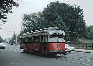
The A branch or Watertown Line was a streetcar line in the Boston, Massachusetts, area, operating as a branch of the Massachusetts Bay Transportation Authority Green Line. The line ran from Watertown through Newton Corner, Brighton, and Allston to Kenmore Square, then used the Boylston Street subway and Tremont Street subway to reach Park Street station.

<span class="mw-page-title-main">East Cambridge, Cambridge, Massachusetts</span> Neighborhood of Cambridge, Massachusetts

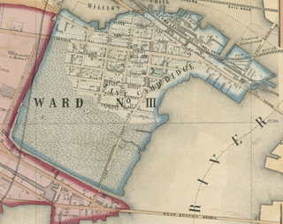
East Cambridge is a neighborhood of Cambridge, Massachusetts. East Cambridge is bounded by the Charles River and the Charlestown neighborhood of Boston on the east, the Somerville border on the north, Broadway and Main Street on the south, and the railroad tracks on the west. Most of the streets form a grid aligned with Cambridge Street, which was laid out to directly connect what is now the Charles River Dam Bridge with what in 1809 was the heart of Cambridge, Harvard Square. The northern part of the grid is a roughly six by eight block residential area. Cambridge Street itself is retail commercial, along with Monsignor O'Brien Highway, the Twin Cities Plaza strip mall, and the enclosed Cambridgeside Galleria. Lechmere Square is the transportation hub for the northern side. The southern half of the grid is largely office and laboratory space for hundreds of dot-com companies, research labs and startups associated with MIT, biotechnology firms including Genzyme, Biogen and Moderna, the Athenaeum Press Building, light industry, an NRG Energy power station, and various small businesses. This half of the neighborhood is generally identified with Kendall Square. Along the waterfront are several hotels and taller apartment buildings.

<span class="mw-page-title-main">Charles River Esplanade</span> State-owned park in Boston, Massachusetts, U.S.

The Charles River Esplanade of Boston, Massachusetts, is a state-owned park situated in the Back Bay area of the city, on the south bank of the Charles River Basin.

<span class="mw-page-title-main">Memorial Drive (Cambridge)</span>

Memorial Drive, colloquially referred to as Mem Drive, is a 3.9-mile (6.3 km) parkway along the north bank of the Charles River in Cambridge, Massachusetts, United States.

<span class="mw-page-title-main">Storrow Drive</span> Parkway along the Charles River in Boston

Storrow Drive, officially James Jackson Storrow Memorial Drive, is a major crosstown parkway in Boston, Massachusetts, running east–west along the southern bank of the Charles River. It is restricted to cars; trucks and buses are not permitted on it, while pedestrian access is available via walking paths on the Charles River side of the road. Boston drivers use the route for quick access to downtown locations.

<span class="mw-page-title-main">Anderson Memorial Bridge</span> Bridge in Massachusetts to Boston, Massachusetts

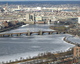
Anderson Memorial Bridge connects Allston, a neighborhood of Boston, and Cambridge. The bridge stands on the site of the Great Bridge built in 1662, the first structure to span the Charles River. It brings Boston traffic into Harvard Square and was finished in 1915.

<span class="mw-page-title-main">Charles River Bike Path</span> Bicycle path in Boston, Massachusetts

The Charles River Bike Path is a mixed-use path in the Boston, Massachusetts area. It is named after the cardiologist Paul Dudley White, a prominent advocate of preventive medicine. His research led him to proclaim frequently "I'd like to put everybody on bicycles." In 1955 White served as president Eisenhower's cardiologist and prescribed his famous patient bicycle therapy after his 1955 heart attack.

<span class="mw-page-title-main">Charles River Reservation Parkways</span> Historic district in the United States

The Charles River Reservation Parkways are parkways that run along either side of the Charles River in eastern Massachusetts. The roads are contained within the Charles River Reservation and the Upper Charles River Reservation, and fall within a number of communities in the greater Boston metropolitan area. The Charles River parks extend from the Charles River Dam, where the Charles empties into Boston Harbor, to Riverdale Park in the West Roxbury neighborhood of Boston. Most of the roadways within the parks are listed on the National Register of Historic Places as a unit, although Storrow Drive and Memorial Drive are listed as part of the Charles River Basin Historic District.

<span class="mw-page-title-main">Main Yarra Trail</span>

The Main Yarra Trail, also known as the Yarra Trail is a shared-use path for cyclists and pedestrians, which follows the Yarra River through the northeastern suburbs of Melbourne, Victoria, Australia.

<span class="mw-page-title-main">John W. Weeks Bridge</span> Charles River overpass

The John W. Weeks Memorial Bridge, usually called the Weeks Footbridge or simply Weeks Bridge, is a pedestrian bridge over the Charles River, located four miles northwest of downtown Boston on the Harvard University campus. The bridge connects Harvard’s original Cambridge campus with the Harvard Business School and many of the school’s athletic facilities in Allston.

<span class="mw-page-title-main">Eliot Bridge</span> Bridge in Cambridge, Massachusetts to Allston

The Eliot Bridge is a bridge over the Charles River between Cambridge, Massachusetts and Allston, Boston, Massachusetts. It connects Soldiers Field Road in Allston with Gerry's Landing Road, Memorial Drive, Greenough Boulevard, and the Fresh Pond Parkway in Cambridge.

<span class="mw-page-title-main">U.S. Route 20 in Massachusetts</span> Section of U.S. Highway in Massachusetts

U.S. Route 20 (US 20) runs its easternmost 153 miles (246 km) in the U.S. state of Massachusetts. The highway crosses the state border from New Lebanon, New York, into Hancock and runs eastward to Boston, where it ends at Route 2 in Kenmore Square. It spends the vast majority of its journey paralleling I-90, which has largely superseded US 20 for through travel. Still, US 20 directly serves many towns and local business areas which the turnpike bypasses.

<span class="mw-page-title-main">North Beacon Street Bridge</span> Bridge in Massachusetts to Boston, Massachusetts

The North Beacon Street Bridge is a bridge carrying North Beacon Street over the Charles River between Watertown, MA and Brighton, Boston, MA. It was built in 1917.

<span class="mw-page-title-main">Leverett Circle</span>

Leverett Circle is an intersection in Boston, Massachusetts, United States. Completely rebuilt during the Big Dig, it is no longer a rotary. It marks the confluence of Storrow Drive, Charles River Dam Road, Nashua Street, Charles Street, and Martha Road.

<span class="mw-page-title-main">Charles River Speedway</span> Former bicycle and harness racing track in Allston, USA

The Charles River Speedway was a former bicycle and harness racing track located in Allston, Massachusetts, which has been redeveloped into an upscale market.

References

  1. 1 2 Office of Geographic and Environmental Information (MassGIS), Commonwealth of Massachusetts Executive Office of Environmental Affairs – http://www.mass.gov/mgis/dd-over.htm
  2. 1 2 Google (November 23, 2014). "Soldiers Field Road" (Map). Google Maps . Google. Retrieved November 23, 2014.
  3. "After Harvard Visit, Dozens Injured in Bus Crash". USA Today. February 4, 2013. Retrieved February 4, 2013.
  4. "Allston Trotting Parks". Brighton Allston Historical Society. Retrieved November 23, 2014.

See also