This article needs additional citations for verification .(November 2009) |

Blackstone and Franklin Squares are public parks located in the South End neighborhood of Boston, Massachusetts.
This article needs additional citations for verification .(November 2009) |
Blackstone and Franklin Squares are public parks located in the South End neighborhood of Boston, Massachusetts.

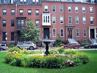
The two squares are separated by Washington Street and bounded on the north by Brookline Street, to the east by St George Street, to the south by Newton Street, and to the west by Shawmut Avenue. An iron fence surrounds the perimeter of each square, with entrances at each of the corners. There is also an entrance to Blackstone Square at the intersection of Pembroke Street and Shawmut Avenue and a fifth entrance to Franklin Square along Newton Street.
Blackstone Square encompasses 2.44 acres (0.99 ha) and Franklin Square spans 2.48 acres (1.00 ha). Both are maintained under Land and Water Conservation Fund of the National Park Service [1]
The squares operate under Article 97 of the Massachusetts State Constitution, which states:
... The people shall have the right to clean air and water, freedom from excessive and unnecessary noise, and the natural, scenic, historic, and esthetic qualities of their environment; and the protection of the people in their right to the conservation, development and utilization of the agricultural, mineral, forest, water, air and other natural resources is hereby declared to be a public purpose.
In the furtherance of the foregoing powers, the general court shall have the power to provide for the taking, upon payment of just compensation therefor, or for the acquisition by purchase or otherwise, of lands and easements or such other interests therein as may be deemed necessary to accomplish these purposes.
Lands and easements taken or acquired for such purposes shall not be used for other purposes or otherwise disposed of except by laws enacted by a two thirds vote, taken by yeas and nays, of each branch of the general court. The general court shall have the power to enact legislation necessary or expedient to protect such rights. [2]
Blackstone and Franklin Square can be reached by the MBTA Silver Line routes SL4 and SL5, and bus routes #8 and #10. [3]
| | This section needs expansion. You can help by adding to it. (May 2016) |

Charles Bulfinch, who created the plan for the South End, originally intended the two squares to be one, calling it Columbia Square. [4] Franklin Square opened in 1849 and Blackstone Square subsequently opened in 1855.
The St. James Hotel, now the Franklin Square House Apartments, served as the exterior backdrop of the popular 1980's NBC hospital drama series, St. Elsewhere . [5]
In 1979, after years of neglect, local resident Brian Davidson began an effort to clean up the squares. He personally picked up trash and after several years the city of Boston began a revitalization project that included new fences, fountains, benches, and trees.[ citation needed ]
A variety of trees are planted in and around the parks. Surrounding the exterior perimeter of the park are Sugar Maple (Acer saccharum). Inside the park and lining the walkways are Silver Linden (Tilia tomentosa). There is a large White Oak (Quercus alba) in Franklin Square as well.
There are two identical fountains, one in each square, located centrally at the intersection of the walkways. At the base of each fountain are four stylized fish surrounding an ornate pedestal that holds a large bowl in the shape of a seashell.

The Red Line is a rapid transit line operated by the Massachusetts Bay Transportation Authority (MBTA) as part of the MBTA subway system. The line runs south and east underground from Alewife station in North Cambridge through Somerville and Cambridge, surfacing to cross the Longfellow Bridge then returning to tunnels under Downtown Boston. It continues underground through South Boston, splitting into two branches on the surface at JFK/UMass station. The Ashmont branch runs southwest through Dorchester to Ashmont station, where the connecting light rail Mattapan Line continues to Mattapan station. The Braintree branch runs southeast through Quincy and Braintree to Braintree station.

The Boston Common is a public park in downtown Boston, Massachusetts. It is the oldest city park in the United States. Boston Common consists of 50 acres (20 ha) of land bounded by five major Boston streets: Tremont Street, Park Street, Beacon Street, Charles Street, and Boylston Street.
The South End is a neighborhood in Boston, Massachusetts, United States which is bordered by Back Bay, Chinatown, and Roxbury. It is distinguished from other neighborhoods by its Victorian-style houses and the parks in and around the area. The South End is the largest intact Victorian row-house district in the country, covering over 300 acres (120 ha). It has eleven residential parks. In 1973, the South End was listed on the National Register of Historic Places. Much of the neighborhood was originally marshlands in Boston's South Bay. After it was filled in, construction began on January 7, 1849.

Copley Square is a public square in Boston's Back Bay neighborhood, bounded by Boylston Street, Clarendon Street, St. James Avenue, and Dartmouth Street. The square is named for painter John Singleton Copley. Prior to 1883 it was known as Art Square due to its many cultural institutions, some of which remain today.

Davis Square is a major intersection in the northwestern section of Somerville, Massachusetts, United States, where several streets meet: Holland Street, Dover Street, Day Street, Elm Street, Highland Avenue, and College Avenue. The name is often used to refer to the West Somerville neighborhood surrounding the square as well.

Park Street station is an MBTA subway station in Boston, Massachusetts. It is located at the intersection of Park Street and Tremont Street at the eastern edge of Boston Common in Downtown Boston. One of the two oldest stations on the "T", and part of the oldest subway line in the United States, Park Street is the transfer point between the Green and Red lines, as one of the quartet of "hub stations" on the MBTA subway system. Park Street is the fifth-busiest station in the MBTA network, with an average of 16,571 entries each weekday in FY2019.

Downtown Crossing station is an underground Massachusetts Bay Transportation Authority (MBTA) rapid transit station located in the Downtown Crossing retail district in the downtown core of Boston, Massachusetts. It is served by the Orange Line and Red Line, and is one of four "hub stations" on the MBTA subway system. Downtown Crossing is also a major bus transfer location serving 13 MBTA bus routes, including one Silver Line route. It is the second busiest subway station in the MBTA network, with an average of 24,074 entries per weekday in FY2019.

Wellington station is a Massachusetts Bay Transportation Authority (MBTA) Orange Line rapid transit station in Medford, Massachusetts, near the border of Everett. It is located on the Revere Beach Parkway, slightly east of its intersection with Route 28. Wellington functions as a park and ride with more than 1,300 spaces, and a bus hub with eight routes terminating at the station. The Station Landing development, connected to the station by an overhead walkway, includes residential and retail buildings and additional parking. Wellington Carhouse, the primary repair and maintenance facility for the Orange Line, is located adjacent to the station.
Four buildings in Boston, Massachusetts, have been known as the "John Hancock Building." All were built by the John Hancock Insurance companies. References to the John Hancock building usually refer to the 60-story, sleek glass building on Clarendon Street also known as the John Hancock Tower or Hancock Place.

The Public Garden, also known as Boston Public Garden, is a large park in the heart of Boston, Massachusetts, adjacent to Boston Common. It is a part of the Emerald Necklace system of parks and is bounded by Charles Street and Boston Common to the east, Beacon Street and Beacon Hill to the north, Arlington Street and Back Bay to the west, and Boylston Street to the south. The Public Garden was the first public botanical garden in America.

Ashmont station is a Massachusetts Bay Transportation Authority (MBTA) intermodal transit station located at Peabody Square in the Dorchester neighborhood of Boston, Massachusetts. It is the southern terminus of the Ashmont branch of the rapid transit Red Line, the northern terminus of the connecting light rail Mattapan Line, and a major terminal for MBTA bus service. Ashmont has two side platforms serving the below-grade Red Line and a single side platform on an elevated balloon loop for the Mattapan Line. The station is fully accessible for all modes.
Washington Square is a neighborhood in Brookline, Massachusetts, United States.
Park Street is a short but historic road in the center of Boston, Massachusetts. It begins at the top of Beacon Hill, at the intersection of Beacon Street, where it is lined up with the front of the Massachusetts State House. It then spills down the hill toward Tremont Street, with Boston Common to its west.

Franklin/Dean College station is an MBTA Commuter Rail station located in Franklin, Massachusetts, near Dean College. It serves the Franklin/Foxboro Line, for which it was the terminus from 1966 to 1988. The station has a mid-sized park and ride lot to serve town residents; Forge Park/495 station is intended to serve commuters from other nearby towns. The 1912-built station building still serves as a waiting hall and café, open during morning commute hours on weekdays. Franklin/Dean College station has a single side platform serving the line's single track; it is not accessible.

Readville station is a Massachusetts Bay Transportation Authority (MBTA) commuter rail station located in the Readville section of the Hyde Park neighborhood of Boston, Massachusetts. It is served by the MBTA Commuter Rail Fairmount, Franklin/Foxboro, and Providence/Stoughton Lines. Readville is the outer terminus for most Fairmount service, though some trips continue as Franklin/Foxboro Line trains. The station is located at a multi-level junction, with the Attleboro Line tracks at ground level and the Dorchester Branch above. Franklin/Foxboro Line trains that run on the Northeast Corridor use a connecting track with a separate platform. An MBTA maintenance and storage yard and a CSX Transportation freight yard are located near the station.

Shawmut station is a subway station in Boston, Massachusetts. It serves the Ashmont branch of the MBTA's Red Line. It is located on Dayton Street in the Dorchester neighborhood. The station, the only underground station on the Red Line south of Andrew station, sits in a shallow cut-and-cover subway tunnel that runs from Park Street south to Peabody Square where it surfaces at Ashmont station. Shawmut opened along with Ashmont on September 1, 1928, as part of a southward extension of the Cambridge–Dorchester line.
Chester Square is a residential garden square located along Massachusetts Avenue in Boston, between Tremont Street and Shawmut Avenue. The name "Chester" is derived from the original name of the street, which was renamed Massachusetts Avenue on March 1, 1894. Chester Park is also located in the historic South End of Boston.

Hanover Street is located in the North End of Boston, Massachusetts.

Union Square is a square in the Allston neighborhood of Boston, Massachusetts at the intersection of Cambridge Street and Brighton Avenue/North Beacon Street. Union Square is serviced by the MBTA 57, 64, 66, 501, and 503 buses. There is also a station for the Blue Bikes bicycle sharing system in Union Square.
Brigham Circle is located at the intersection of Tremont Street and Huntington Avenue in the Mission Hill neighborhood of Boston, Massachusetts. The commercial center of Mission Hill, it forms the southern tip of the Longwood Medical Area.
