Park Square (Boston)

Last updated

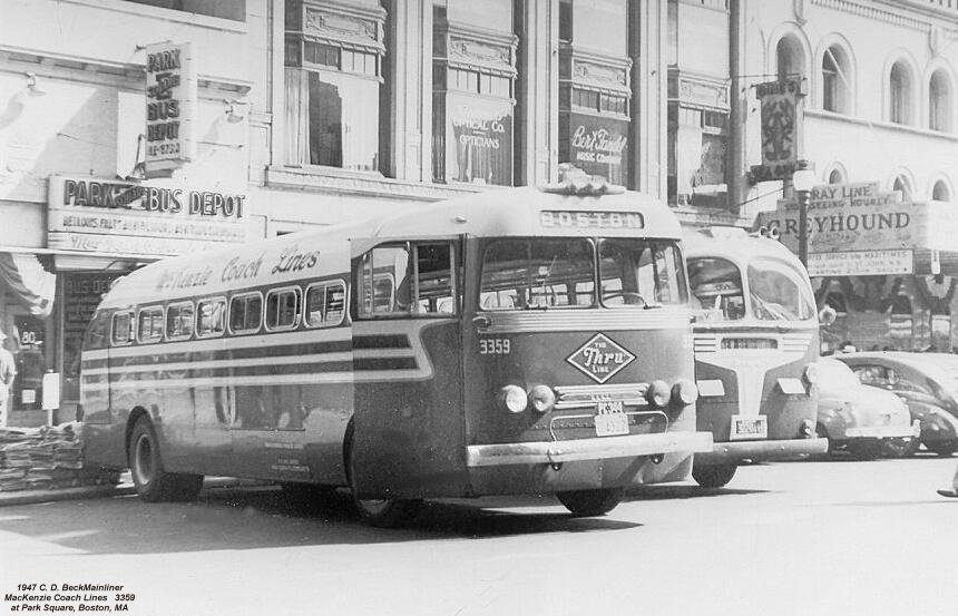
Park Square in downtown Boston, Massachusetts is bounded by Stuart, Charles Street South, Boylston, and Arlington Streets.[ citation needed ] It is the home of the Boston Four Seasons Hotel, the Boston Park Plaza, and nearly a dozen restaurants. To the north across Boylston Street is the Boston Public Garden. To the east is the Washington Street Theatre District. The Bay Village neighborhood is to the south, and Back Bay is to the west. [1]

Contents

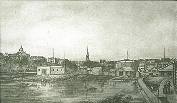
At one time, the terminus of the Boston and Providence Railroad was in the square; however, after South Station opened, the terminal was closed. A statue commemorating US emancipation of slaves was installed in Park Square in 1879 and removed in December 2020. [2] From 1964 to 1974, the University of Massachusetts Boston campus was located in Park Square. [3]

A small street in the district was renamed "Park Plaice" in honor of Legal Sea Foods, a local restaurant. [4] [5]

Education

Boston Public Schools operates area district public schools.

Boston Renaissance Charter Public School was formerly located in a building in Park Square. [6] In 2010 it moved to its current location in Hyde Park. [7]

See also

Related Research Articles

<span class="mw-page-title-main">Boston Public Library</span> Library in Massachusetts, US

The Boston Public Library is a municipal public library system in Boston, Massachusetts, founded in 1848. The Boston Public Library is also Massachusetts' Library for the Commonwealth, meaning all adult residents of the state are entitled to borrowing and research privileges, and the library receives state funding. The Boston Public Library contains approximately 24 million items, making it the third-largest public library in the United States behind the federal Library of Congress and New York Public Library, which is also privately endowed. In 2014, the library held more than 10,000 programs, all free to the public, and lent 3.7 million materials.

<span class="mw-page-title-main">Harvard Yard</span> Oldest part of the Harvard University campus

Harvard Yard, in Cambridge, Massachusetts, is the oldest part of the Harvard University campus, its historic center and modern crossroads. It contains most of the freshman dormitories, Harvard's most important libraries, Memorial Church, several classroom and departmental buildings, and the offices of senior University officials including the President of Harvard University.

<span class="mw-page-title-main">Back Bay, Boston</span> Neighborhood of Boston, Massachusetts, and US historic place

Back Bay is an officially recognized neighborhood of Boston, Massachusetts, built on reclaimed land in the Charles River basin. Construction began in 1859, as the demand for luxury housing exceeded the availability in the city at the time, and the area was fully built by around 1900. It is most famous for its rows of Victorian brownstone homes—considered one of the best preserved examples of 19th-century urban design in the United States—as well as numerous architecturally significant individual buildings, and cultural institutions such as the Boston Public Library, and Boston Architectural College. Initially conceived as a residential-only area, commercial buildings were permitted from around 1890, and Back Bay now features many office buildings, including the John Hancock Tower, Boston's tallest skyscraper. It is also considered a fashionable shopping destination and home to several major hotels.

<span class="mw-page-title-main">Copley Square</span> Square in Back Bay, Boston, Massachusetts

Copley Square, is a public square in Boston's Back Bay neighborhood, bounded by Boylston Street, Clarendon Street, St. James Avenue, and Dartmouth Street. The square is named for painter John Singleton Copley. Prior to 1883 it was known as Art Square due to its many cultural institutions, some of which remain today.

<span class="mw-page-title-main">Newbury Street</span> Exclusive street in Boston

Newbury Street is located in the Back Bay area of Boston, Massachusetts, in the United States. It runs roughly east–west, from the Boston Public Garden to Brookline Avenue. The road crosses many major arteries along its path, with an entrance to the Massachusetts Turnpike westbound at Massachusetts Avenue. Newbury Street is a destination known for its many retail shops and restaurants.

<span class="mw-page-title-main">Fenway–Kenmore</span> Neighborhood in Boston in Suffolk, Massachusetts, United States

Fenway–Kenmore is an officially recognized neighborhood of Boston, Massachusetts. While it is considered one neighborhood for administrative purposes, it is composed of numerous distinct sections that, in casual conversation, are almost always referred to as "Fenway", "the Fenway", "Kenmore Square", or "Kenmore". Furthermore, the Fenway neighborhood is divided into two sub-neighborhoods commonly referred to as East Fenway/Symphony and West Fenway.

<span class="mw-page-title-main">Roslindale</span> Neighborhood of Boston in Suffolk, Massachusetts, United States

Roslindale is a primarily residential neighborhood of Boston, Massachusetts, bordered by Jamaica Plain, Hyde Park, West Roxbury and Mattapan. It is served by an MBTA Commuter Rail line, several MBTA bus lines and the MBTA Orange Line in nearby Jamaica Plain. Roslindale has its own branch of the Boston Public Library, the neighborhood is covered by Boston Police District E-5 in West Roxbury, Boston EMS Ambulance 17 is stationed in Roslindale, and the Boston Fire Department has a station on Canterbury Street which houses Ladder 16, Engine 53 & District Chief 12. Roslindale's original Engine Company 45, was deactivated on April 10, 1981, due to budget cuts. Roslindale was once called the "garden suburb" of Boston. The portion of the Arnold Arboretum south of Bussey Street is located in Roslindale.

<span class="mw-page-title-main">Hynes Convention Center station</span> Subway station in Boston, Massachusetts, US

Hynes Convention Center station is an underground light rail station on the Massachusetts Bay Transportation Authority (MBTA) Green Line. It is located at the intersection of Newbury Street and Massachusetts Avenue near the western end of the Back Bay neighborhood of Boston, Massachusetts. The station is named for the Hynes Convention Center, which is located about 700 feet (210 m) to the east along Boylston Street. It has two side platforms serving the two tracks of the Boylston Street subway, which are used by the Green Line B branch, C branch, and D branch. The main entrance to the station from Massachusetts Avenue leads to a fare lobby under the 360 Newbury Street building.

<span class="mw-page-title-main">Hyde Park, Boston</span> Neighborhood of Boston in Suffolk, Massachusetts, United States

Hyde Park is the southernmost neighborhood of Boston, Massachusetts, United States. Situated 7.9 miles south of downtown Boston, it is home to a diverse range of people, housing types and social groups. It is an urban location with suburban characteristics.

Washington Street is a street originating in downtown Boston, Massachusetts, which extends southwestward to the Massachusetts–Rhode Island state line. The majority of its length outside of the city was built as the Norfolk and Bristol Turnpike in the early 19th century. It is the longest street in Boston and remains one of the longest streets in the Commonwealth of Massachusetts. Due to various municipal annexations with the city of Boston, the name Washington Street now exists 6 or more times within the jurisdiction(s) of the City of Boston.

<span class="mw-page-title-main">Bay Village, Boston</span> Neighborhood of Boston in Suffolk, Massachusetts, United States

Bay Village is the smallest officially recognized neighborhood of Boston, Massachusetts. As of 2010, its population was approximately 1,312 residents living in 837 housing units, most of which are small brick rowhouses.

<span class="mw-page-title-main">Huntington Avenue</span> Thoroughfare in Boston, United States

Huntington Avenue is a thoroughfare in the city of Boston, Massachusetts, beginning at Copley Square and continuing west through the Back Bay, Fenway, Longwood, and Mission Hill neighborhoods. It is signed as Massachusetts Route 9. A section of Huntington Avenue has been officially designated the Avenue of the Arts by the city of Boston.

<span class="mw-page-title-main">Tremont Street</span> Road in Boston Massachusetts

Tremont Street is a major thoroughfare in Boston, Massachusetts.

<span class="mw-page-title-main">Stony Brook station (MBTA)</span> Rapid transit station in Boston, Massachusetts, US

Stony Brook station is a rapid transit station in Boston, Massachusetts. It serves the MBTA Orange Line and is located below grade at Boylston Street in the Jamaica Plain neighborhood. The station opened on May 4, 1987, as part of the Southwest Corridor project, replacing an earlier station that was open from 1897 to 1940.

<span class="mw-page-title-main">Downtown Boston</span> Area of Boston Massachusetts

Downtown Boston is the central business district of Boston, Massachusetts, United States. Boston was founded in 1630. The largest of the city's commercial districts, Downtown is the location of many corporate or regional headquarters; city, county, state and federal government facilities; and many of Boston's tourist attractions. Similar to other central business districts in the U.S., Downtown has recently undergone a transformation that included the construction of new condos and lofts, renovation of historic buildings, and arrival of new residents and businesses. It is represented in the Boston City Council by District 2's Bill Linehan.

<span class="mw-page-title-main">South Station Bus Terminal</span>

The South Station Bus Terminal, owned by the Massachusetts Bay Transportation Authority, is the main gateway for long-distance coach buses in Boston, Massachusetts. It is located at 700 Atlantic Avenue, at the intersection with Beach Street, in the Chinatown/Leather District neighborhoods. The facility is immediately south-southwest of the main MBTA/Amtrak South Station terminal, and is located above the station platforms and tracks.

<span class="mw-page-title-main">Fenway Theatre</span>

The Fenway Theatre (1915–1972) of Boston, Massachusetts, was a cinema and concert hall in the Back Bay, located at no.136 Massachusetts Avenue at Boylston Street.

<span class="mw-page-title-main">Columbus Square (Providence)</span> Historic public square in Rhode Island, United States

Columbus Square is a historic public square in the Historic Elmwood Neighborhood of Providence, Rhode Island. Located at the intersection of Elmwood Avenue and Reservoir Avenue, it serves as a gateway to Elmwood from the Reservoir and West End Neighborhoods.

<span class="mw-page-title-main">Ipswich Street line</span> Former streetcar line in Boston and Brookline, Massachusetts

The Ipswich Street line was a streetcar line in Boston and Brookline, Massachusetts. The line ran on Boylston Street and Ipswich Street in the Fenway–Kenmore neighborhood, and on Brookline Avenue through what is now the Longwood Medical Area to Brookline Village.

<span class="mw-page-title-main">Emancipation Memorial (Boston)</span>

The Emancipation Memorial, also known as the Freedman's Memorial or the Emancipation Group was a monument in Park Square in Boston. Designed and sculpted by Thomas Ball and erected in 1879, its sister statue is located in Lincoln Park in the Capitol Hill neighborhood of Washington, D.C. The Boston statue was taken down by the City of Boston on December 29, 2020, following a unanimous vote from the Boston Art Commission on June 30 to remove the memorial.

References

  1. GUERRA, CRISTELA (July 1, 2020). "Boston To Remove Statue Depicting Abraham Lincoln With Freed Black Man At His Feet". NPR News. Retrieved 2020-07-02.
  2. "Controversial Emancipation Group Statue Being Removed From Boston's Park Square", Cbslocal.com , December 29, 2020
  3. Feldberg, Michael (2015). UMass Boston at 50: A Fiftieth-Anniversary History of the University of Massachusetts Boston. Amherst, Massachusetts: University of Massachusetts Press. pp. 49–69. ISBN   978-1625341693.
  4. "It's Not a Typo!". The Boston Courant. March 30 – April 5, 2012. p. 1. 'Park Plaice' was named after the fish in honor of Legal Sea Foods' relocation to Park Square in 1999.
  5. @CityOfBoston (February 26, 2016). "It's not a typo. Plaice is a type of fish. The street was renamed in honor of Legal Sea Foods' relocation to Park Sq in 1999" (Tweet). Retrieved 2020-07-02 via Twitter.
  6. Andersen, Travis (2013-02-26). "Renaissance Charter School on probation". Boston Globe . Retrieved 2017-04-20.
  7. "New - About Archived 2016-02-05 at the Wayback Machine ." Boston Renaissance Charter Public School. Retrieved on April 20, 2017.

42°21′06″N71°04′06″W / 42.3516°N 71.0684°W / 42.3516; -71.0684