Bay Village, Boston

Last updated
Bay Village
Bay Village, Boston, MA - view 1.JPG
Bay Village, Boston
Bay Village, Boston
Location in Boston
Country United States
State Massachusetts
County Suffolk
Neighborhood of Boston
Population
 (2010)
1,312
Time zone UTC-5 (Eastern)
Zip Code
02116
Area code 617 / 857
Website www.bayvillage.net

Bay Village is the smallest officially recognized neighborhood of Boston, Massachusetts. As of 2010, its population was approximately 1,312 residents living in 837 housing units, most of which are small brick rowhouses. [1]

Contents

Description

The Massachusetts Turnpike is the southern boundary of the neighborhood, which coincides with the right-of-way of the former Boston and Worcester Railroad, laid down in the 1830s. Marginal Road and Cortes Street are the surface roads that parallel "the Pike". Across the Pike to the southwest lies the South End neighborhood; to the southeast of the Pike and Tremont Street is the southern edge of Chinatown. To the west of Berkeley Street and north of Columbus Avenue (west of Arlington Street) is the Back Bay neighborhood. To the north of Stuart Street is Park Square, and to the east of Charles Street is the Washington Street Theatre District. [2] [3]

In 1983, the area bounded by Cortes Street, Tremont Street, Piedmont Street, and Isabella Street was designated as the "Bay Village Historic District" by the Boston Landmarks Commission. The exterior appearance of buildings is protected by a Historic District designation administered by the Bay Village Historic District Commission. [4]

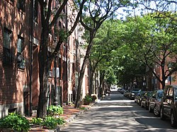
The narrow one-way network and irregular grid arrangement of the streets make the interior urban spaces of Bay Village relatively quiet and pedestrian-friendly, due to sparse automobile traffic. Most of the sidewalks are paved with brick, and are lit by gas streetlamps at night. One small street is still paved with original cobblestones, while the remainder have long ago been repaved with asphalt.

The old armory on Arlington Street The Tower, aka Armory of the First Corps of Cadets, Boston.jpg
The old armory on Arlington Street

There are a few "vest-pocket parks" located within or nearby Bay Village, including Eliot Norton Park, which although technically located in the Theatre District, is just across Charles Street from the eastern boundary of the neighborhood. [3] The Boston Public Garden and Boston Common are located just two blocks away from the northern edge of Bay Village.

Traditionally middle to lower-middle class, the neighborhood has become relatively more expensive and upscale, beginning around the 1990s.[ citation needed ] The Bay Village Neighborhood Association (BVNA) is very active in controlling urban nuisances, such as traffic, litter, graffiti, and pet wastes (an approved dog walking area is located next to Eliot Norton Park). The BVNA is also known for organizing Spring and Fall Cleanup days, a book club, and the Bay Village Annual Neighborhood Block Party. The party includes restaurant seating and service in the middle of the narrow streets, weather permitting. [5]

History

The House at 1 Bay Street, an 1830 house listed on the National Register of Historic Places (NRHP) BostonMA 1BayStreet.jpg
The House at 1 Bay Street, an 1830 house listed on the National Register of Historic Places (NRHP)

The western part of the neighborhood was originally part of the body of water known as the Back Bay, west of the Boston Neck isthmus. This area was once known as South Bay, as the original waterline was in the area of Charles Street and Broadway (formerly Carver Street and Pleasant Street). [6] In the 1820s, the neighborhood was landfilled by developer Ephraim Marsh, [7] in partnership with Francis Cabot Lowell Jr, before the more extensive landfills of the adjacent Back Bay and South End neighborhoods. [8] Through its history, the neighborhood has been known at different times as the Church Street District, South Cove, and Kerry Village. [9]

Architecturally, many Bay Village homes look like smaller versions of Beacon Hill townhouses. This is largely because many of the craftspeople who built the Beacon Hill residences settled in this area and built the local residences for their own use. [10] Fayette Street, named for the American Revolutionary War soldier Marquis de Lafayette, has numerous houses dating from the Federal Period. Grander five-story townhouses in the Greek Revival style may be found on Melrose Street. After the area west of Ferdinand Street was filled in, developers built luxury residential "hotels" in the Victorian style on Cortes and Isabella Streets.

Raising the Village

Houses on north side of Fayette Street, west of Church Street, being raised in 1868. Church St District Boston Fayette St Facing West, North Side, Being Raised 1868.jpg
Houses on north side of Fayette Street, west of Church Street, being raised in 1868.

In 1868, the majority of what is now Bay Village was raised in order to eliminate sewage problems created by the filling of the adjacent South End and Back Bay neighborhoods. [6] Some 457 houses and 24 other structures were raised by 12 feet (3.7 m) to a grade of 18 feet (5.5 m) above mean low water, with cellars, gardens and vacant lots raised to 6 feet (1.8 m) above mean low water. [11] The total cost of this massive engineering feat was $632,700, compared to a total estimated value of $1,668,120 for all of the structures raised. [11] To complete the work, the City of Boston temporarily took possession of all the structures in the area, exchanging them for City bonds with the property owners. There were 3,528 displaced individuals in total, coming from 867 families, and the work took around two years to complete. Once the structures and streets were raised, and the new sewer system was functional, the structures were returned to the property owners. [11]

Houses on south side of Fayette Street, west of Church Street, being raised in 1868. Church St District Boston Fayette St Facing West, South Side, Being Raised 1868.jpg
Houses on south side of Fayette Street, west of Church Street, being raised in 1868.
The Church Street Church after being raised in 1868. Church St District Boston Church Being Raised 1868.jpg
The Church Street Church after being raised in 1868.

Many of the raised structures were modified with new entrances into what had previously been the second floor. Visitors can see evidence of this today by noting the location of the basement windows in some of the buildings on Fayette Street, as well as arches opening to horsewalks that ran under the houses to stables in the rear. In addition, some private gardens were never raised, and remain near their original elevations. [12] The Church Street Church, for which Church street was named, was raised and "much altered by 1868 (at the time of the raising of the district)." [6] The church, which was located between the current Winchester and Piedmont Streets, was later demolished in 1924.

Edgar Allan Poe

The American writer Edgar Allan Poe was born at the edge of Bay Village; his parents were both actors in the Theatre District nearby. A commemorative plaque on Boylston Street is a couple of blocks away from the actual location of Poe's birth. [13] The house which was his birthplace at 62 Carver Street no longer exists; also, the street has since been renamed "Charles Street South". [14] [15] A "square" at the intersection of Broadway, Fayette, and Carver Streets had once been named in his honor, [16] but it disappeared when the streets were rearranged. In 2009, the intersection of Charles and Boylston Streets (two blocks north of his birthplace) was newly designated "Edgar Allan Poe Square". [17] A residential condominium a few streets away within Bay Village is also named in his honor, but otherwise has no known connection to the author.

In 2014, a permanent memorial bronze sculpture by Stefanie Rocknak was installed at Edgar Allan Poe Square. Poe Returning to Boston depicts a life-sized Poe striding against the wind, accompanied by a flying raven; his suitcase lid has fallen open, leaving a "paper trail" of literary works embedded in the sidewalk behind him. [18] [19] [20] [21] [22] [23]

Cocoanut Grove fire

Memorial plaque installed in the sidewalk near the site of the Cocoanut Grove fire Cocoanut Grove Memorial.jpg
Memorial plaque installed in the sidewalk near the site of the Cocoanut Grove fire

Bay Village was the site of the November 1942 fire at the Cocoanut Grove nightclub, in which 492 people died. Its terrible aftermath led to the creation and enforcement of stringent fire codes across the US, in the hope of preventing other such tragedies. Marking the 50th anniversary of the incident, the Bay Village Neighborhood Association placed a memorial plaque in the brick sidewalk near the club's former site on Piedmont Street, now partially occupied by the Revere Hotel (formerly the Radisson Hotel). [9] [24] The plaque states:

The Cocoanut Grove. Erected by the Bay Village Neighborhood Association, 1993. In memory of the more than 490 people who died in the Cocoanut Grove fire on November 28, 1942. As a result of that terrible tragedy, major changes were made in the fire codes, and improvements in the treatment of burn victims, not only in Boston but across the nation. "Phoenix out of the Ashes"

A smaller inscription in the lower left corner says, "This plaque crafted by Anthony P. Marra, youngest survivor of the Cocoanut Grove fire".

On November 30, 2013, a short street running through the former site of the Cocoanut Grove Club, and previously named "Shawmut Extension", was renamed "Cocoanut Grove Lane". The on-site renaming ceremony was attended by several survivors of the fire and around 250 guests and spectators. Speakers included Marty Walsh, who had recently been elected mayor of Boston, but not yet sworn into office. [25] [26]

The plaque was removed in 2014 for the construction of new condominium residences on the site, [27] but was reinstalled in June 2016 as previously agreed to by the developer. [28] However a few weeks later, the plaque was relocated to the corner of Cocoanut Grove Lane nearby, at the request of some condominium owners. The relocation was objected to by the surviving daughter of Anthony P. Marra (who had designed the plaque), with support from other interested parties. [28] [26] According to a Boston Globe article, the condo owners stated "We now occupy these homes with our families as part of the Bay Village neighborhood and would like to enjoy our homes in peace, without tragic memories, hanging wreaths at our doors and tourists peeking into our houses". [28] One of the condominium developers has claimed that the new placement of the plaque is closer to the original location of the infamous revolving door at the entrance to the nightclub, which had become jammed in the panic and had trapped many victims. [26]

Demographics

Race and ancestry

Back Bay/Bay Village (02116) Racial Breakdown of Population (2017) [29] [30]
RacePercentage of
02116
population
Percentage of
Massachusetts
population
Percentage of
United States
population
ZIP Code-to-State
Difference
ZIP Code-to-USA
Difference
White 77.1%81.3%76.6%–4.2%+0.5%
White (Non-Hispanic) 70.9%72.1%60.7%–1.2%+10.2%
Asian 14.4%6.9%5.8%+7.5%+8.6%
Hispanic 7.5%11.9%18.1%–4.4%–10.6%
Black 4.9%8.8%13.4%–3.9%–8.5%
Native Americans/Hawaiians 0.2%0.6%1.5%–0.4%–1.3%
Two or more races 2.2%2.4%2.7%–0.2%–0.5%

According to the 2012-2016 American Community Survey 5-Year Estimates, the largest ancestry groups in ZIP Codes 02116 are: [31] [32]

AncestryPercentage of
02116
population
Percentage of
Massachusetts
population
Percentage of
United States
population
ZIP Code-to-State
Difference
ZIP Code-to-USA
Difference
Irish 16.93%21.16%10.39%–4.23%+6.54%
Italian 10.58%13.19%5.39%–2.61%+5.19%
Chinese 10.16%2.28%1.24%+7.88%+8.92%
German 9.82%6.00%14.40%+3.82%–4.58%
English 9.39%9.77%7.67%–0.39%+1.72%
Polish 4.84%4.67%2.93%+0.17%+1.91%
Russian 4.18%1.65%0.88%+2.53%+3.30%
French 3.25%6.82%2.56%–3.58%+0.69%
Scottish 2.65%2.28%1.71%+0.37%+0.94%
American 2.46%4.26%6.89%–1.80%–4.43%
Puerto Rican 2.46%4.52%1.66%–2.06%+0.80%
European 2.08%1.08%1.23%+1.00%–0.85%
Sub-Saharan African 1.72%2.00%1.01%–0.28%+0.71%
Mexican 1.56%0.67%11.96%+0.89%–10.40%
Asian Indian 1.52%1.39%1.09%+0.13%+0.43%
Arab 1.48%1.10%0.59%+0.38%+0.89%
Swedish 1.39%1.67%1.23%–0.28%+0.16%
Cape Verdean 1.38%0.97%0.03%+0.41%+1.35%
French Canadian 1.35%3.91%0.65%–2.55%+0.70%
Greek 1.29%1.22%0.40%+0.07%+0.89%
Dutch 1.27%0.62%1.32%+0.65%–0.05%
Eastern European 1.16%0.42%0.17%+0.74%+0.99%
Scotch-Irish 1.09%0.63%0.96%+0.46%+0.13%
British 1.08%0.48%0.43%+0.60%+0.65%

Transportation

As of 2016, Walk Score rates Bay Village as the fourth most walkable neighborhood in the City of Boston, which itself is rated the third most walkable city in the US, and has a high Transit Score as well. [33] Bay Village has been assigned a Walk Score of 98, and a Transit Score of 100; its lower Bike Score of 71 is still considered "Very Bikeable". [34]

Several MBTA rapid transit stations are located just beyond the boundaries of Bay Village, which is also served by several local bus routes. Commuter rail and Amtrak long-haul trains stop at Back Bay Station and South Station, within walking distance to the west and east of Bay Village, respectively. Inter-city bus services depart from the regional South Station Bus Terminal.

Nearby MBTA stations include:

On-street parking is very scarce within Bay Village, and is mostly reserved for holders of Residential Parking stickers. Commercial parking is available in numerous surface lots and parking garages located near or in the neighborhood. Entrance ramps to the Massachusetts Turnpike (I-90) and the Central Artery (I-93) are a minute's drive away.

Local media

In addition to the larger metropolitan Boston publications, several local weekly newspapers are distributed free in Bay Village. The neighborhood is so small that it is often included in the South End or Back Bay neighborhoods.

The Boston Courant covered the Back Bay, Beacon Hill, Downtown, Fenway, South End, and the Waterfront neighborhoods of Boston, and included dedicated real estate listings for South End / Bay Village, and events calendar listings. However, the newspaper announced that it would permanently shut down, in its February 6, 2016 edition.

Shortly after that announcement, the Back Bay Sun changed its name to the Boston Sun, and expanded its coverage from the Back Bay to also include the South End and Fenway-Kenmore neighborhoods of Boston. The paper is owned by The Independent Newspaper Group (ING), which also publishes The Beacon Hill Times. This latter newspaper has had some coverage of Bay Village, and is of interest because of the close proximity and historical connections to the Beacon Hill neighborhood.

In 2016, the previous publisher of the defunct Boston Courant debuted a reborn publication under the new banner of the Boston Guardian , serving the Back Bay, Beacon Hill, Downtown, Fenway, South End, and North End/Waterfront districts of Boston. The new publication's title stirred up some controversy over the alleged appropriation of a historic journalistic name. [35] [36] [37]

In addition, the Bay Village Neighborhood Association occasionally distributes its free quarterly newsletter in the area, and back issues can be downloaded from its website.

Adjacent neighborhoods and districts

Related Research Articles

<span class="mw-page-title-main">Edgar Allan Poe</span> American writer and literary critic (1809–1849)

Edgar Allan Poe was an American writer, poet, author, editor, and literary critic who is best known for his poetry and short stories, particularly his tales of mystery and the macabre. He is widely regarded as a central figure of Romanticism and Gothic fiction in the United States, and of American literature. Poe was one of the country's earliest practitioners of the short story, and is considered the inventor of the detective fiction genre, as well as a significant contributor to the emerging genre of science fiction. He is the first well-known American writer to earn a living through writing alone, resulting in a financially difficult life and career.

<span class="mw-page-title-main">Cocoanut Grove fire</span> 1942 nightclub fire in Boston, Massachusetts, US

The Cocoanut Grove fire was a nightclub fire which took place in Boston, Massachusetts, on November 28, 1942, and resulted in the deaths of 492 people. It is the deadliest nightclub fire in history and the second-deadliest single-building fire. The Cocoanut Grove was one of Boston's most popular nightspots, attracting many celebrity visitors. It was owned by Barnet "Barney" Welansky, who was closely connected to the Mafia and to Mayor Maurice J. Tobin. Fire regulations had been flouted: some exit doors had been locked to prevent unauthorized entry, and the elaborate palm tree décor contained flammable materials. The air-conditioning used flammable gas because of the wartime shortage of freon.

<span class="mw-page-title-main">Back Bay, Boston</span> Neighborhood of Boston, Massachusetts, and US historic place

Back Bay is an officially recognized neighborhood of Boston, Massachusetts, built on reclaimed land in the Charles River basin. Construction began in 1859, as the demand for luxury housing exceeded the availability in the city at the time, and the area was fully built by around 1900. It is most famous for its rows of Victorian brownstone homes—considered one of the best preserved examples of 19th-century urban design in the United States—as well as numerous architecturally significant individual buildings, and cultural institutions such as the Boston Public Library, and Boston Architectural College. Initially conceived as a residential-only area, commercial buildings were permitted from around 1890, and Back Bay now features many office buildings, including the John Hancock Tower, Boston's tallest skyscraper. It is also considered a fashionable shopping destination and home to several major hotels.

<span class="mw-page-title-main">South Boston</span> Neighborhood of Boston in Suffolk, Massachusetts, United States

South Boston is a densely populated neighborhood of Boston, Massachusetts, located south and east of the Fort Point Channel and abutting Dorchester Bay. South Boston, colloquially known as Southie, has undergone several demographic transformations since being annexed to the city of Boston in 1804. The neighborhood, once primarily farmland, is popularly known by its twentieth century identity as a working class Irish Catholic community. Throughout the twenty-first century, the neighborhood has become increasingly popular with millennial professionals.

<span class="mw-page-title-main">Beacon Hill, Boston</span> Historic neighborhood in Boston, Massachusetts

Beacon Hill is a historic neighborhood in Boston, Massachusetts, and the hill upon which the Massachusetts State House resides. The term "Beacon Hill" is used locally as a metonym to refer to the state government or the legislature itself, much like Washington, D.C.'s Capitol Hill does at the federal level.

<span class="mw-page-title-main">Back Bay Fens</span> Parkland and urban wild in Massachusetts

The Back Bay Fens, often called The Fens, is a parkland and urban wild in Boston, Massachusetts, in the United States. It was established in 1879. Designed by Frederick Law Olmsted to serve as a link in the Emerald Necklace park system, the Fens gives its name to the Fenway-Kenmore neighborhood.

<span class="mw-page-title-main">Fenway–Kenmore</span> Neighborhood in Boston in Suffolk, Massachusetts, United States

Fenway–Kenmore is an officially recognized neighborhood of Boston, Massachusetts. While it is considered one neighborhood for administrative purposes, it is composed of numerous distinct sections that, in casual conversation, are almost always referred to as "Fenway", "the Fenway", "Kenmore Square", or "Kenmore". Furthermore, the Fenway neighborhood is divided into two sub-neighborhoods commonly referred to as East Fenway/Symphony and West Fenway.

<span class="mw-page-title-main">Allston</span> Neighborhood of Boston in Suffolk, Massachusetts, United States

Allston is an officially recognized neighborhood within the City of Boston, Massachusetts. It was named after the American painter and poet Washington Allston. It comprises the land covered by the zip code 02134. For the most part, Allston is administered collectively with the adjacent neighborhood of Brighton. The two are often referred to together as Allston–Brighton. Boston Police Department District D-14 covers the Allston-Brighton area and a Boston Fire Department Allston station is located in Union Square which houses Engine 41 and Ladder 14. Engine 41 is nicknamed "The Bull" to commemorate the historic stockyards of Allston.

<span class="mw-page-title-main">Kenmore Square</span> Square in Boston, Massachusetts, United States

Kenmore Square is a square in the Fenway–Kenmore neighborhood of Boston, Massachusetts. It is formed by the crossing of Beacon Street,Commonwealth Avenue, and Brookline Avenue. It is the eastern terminus of U.S. Route 20, the longest U.S. Highway. The Citgo sign is a prominent landmark in Kenmore Square, and Fenway Park is just to the south. Kenmore station is located under the square, with a surface bus terminal inside the square.

<span class="mw-page-title-main">Downtown Crossing</span> Shopping district in Boston, Massachusetts, United States

<span class="mw-page-title-main">Boston Public Garden</span> Botanical garden in Boston, MA

The Public Garden, also known as Boston Public Garden, is a large park in the heart of Boston, Massachusetts, adjacent to Boston Common. It is a part of the Emerald Necklace system of parks, and is bounded by Charles Street and Boston Common to the east, Beacon Street and Beacon Hill to the north, Arlington Street and Back Bay to the west, and Boylston Street to the south. The Public Garden was the first public botanical garden in America.

<span class="mw-page-title-main">Green Line C branch</span> Light rail line in Massachusetts, US

The C branch, also called the Beacon Street Line or Cleveland Circle Line, is one of four branches of the Massachusetts Bay Transportation Authority's Green Line light rail system in the Boston, Massachusetts metropolitan area. The line begins at Cleveland Circle in the Brighton neighborhood of Boston and runs on the surface through Brookline along the median of Beacon Street. Reentering Boston, the line goes underground through the St. Mary's Street incline and joins the B and D branches at Kenmore. Trains run through the Boylston Street subway to Copley where the E branch joins, then continue through the Tremont Street subway to downtown Boston. The C branch has terminated at Government Center station since October 2021.

<span class="mw-page-title-main">Neighborhoods in Boston</span>

Boston's diverse neighborhoods serve as a political and cultural organizing mechanism. The City of Boston's Office of Neighborhood Services has designated 23 Neighborhoods in the city:

<span class="mw-page-title-main">Back of the Hill station</span> Light rail station in Boston, Massachusetts, US

Back of the Hill station is a surface stop on the light rail MBTA Green Line E branch, located in the Mission Hill neighborhood of Boston, Massachusetts. It is named after, and primarily serves, the adjacent Back of the Hill apartment complex, a Section 8 development for elderly and disabled residents. Back of the Hill is located on the street running section of the E branch on South Huntington Avenue. The station has no platforms; passengers wait in bus shelters on the sidewalks and cross a traffic lane to reach Green Line trains.

<span class="mw-page-title-main">Charles Street (Boston)</span> Street in Boston, U.S.

Charles Street is the name of a north-south street in the city center of Boston, Massachusetts. It begins in the north at Leverett Circle, where it connects with Nashua Street and Monsignor O'Brien Highway. Science Park station on the MBTA Green Line is located there. Charles Street runs south and gives its name to the Charles/MGH station on the MBTA Red Line, connecting via the Charles Circle rotary to Cambridge Street and the Longfellow Bridge which leads to Cambridge. This segment is a one-way street, with traffic heading northwards.

Park Square in downtown Boston, Massachusetts is bounded by Stuart, Charles Street South, Boylston, and Arlington Streets. It is the home of the Boston Four Seasons Hotel, the Boston Park Plaza, and nearly a dozen restaurants. To the north across Boylston Street is the Boston Public Garden. To the east is the Washington Street Theatre District. The Bay Village neighborhood is to the south, and Back Bay is to the west.

<span class="mw-page-title-main">Downtown Boston</span> Area of Boston Massachusetts

Downtown Boston is the central business district of Boston, Massachusetts, United States. Boston was founded in 1630. The largest of the city's commercial districts, Downtown is the location of many corporate or regional headquarters; city, county, state and federal government facilities; and many of Boston's tourist attractions. Similar to other central business districts in the U.S., Downtown has recently undergone a transformation that included the construction of new condos and lofts, renovation of historic buildings, and arrival of new residents and businesses. It is represented in the Boston City Council by District 2's Bill Linehan.

The Boston Courant was a weekly newspaper in Boston, whose coverage focused on issues of local interest to the Back Bay, Beacon Hill, Downtown, Fenway, South End, and Waterfront neighborhoods. It had a circulation of over 40,000. The Boston Courant announced its closure in February 2016 after losing a wrongful termination lawsuit. In April 2016, the former publisher debuted the Boston Guardian, with similar editorial content and neighborhood coverage.

<span class="mw-page-title-main">Aaron Michlewitz</span> Massachusetts politician

Aaron Michlewitz is a Democratic member of the Massachusetts House of Representatives from the 3rd Suffolk District, within the city of Boston, Massachusetts. The 3rd Suffolk District encompasses the North End, Waterfront, Chinatown, South End, Financial District, Bay Village, Leather District, and parts of Beacon Hill, and Back Bay neighborhoods.

<span class="mw-page-title-main">Boston Stone</span>

References

  1. Boston 2010 Census BRA neighborhood comparison
  2. Boundaries of the neighborhood as defined by the Bay Village Neighborhood Association: see map Archived December 1, 2006, at the Wayback Machine
  3. 1 2 "Bay Village Historic District (map)" (PDF). CityofBoston.gov. Retrieved 2011-07-26.
  4. "Bay Village". CityofBoston.gov. City of Boston. Archived from the original on 20 July 2011. Retrieved 2011-07-03.
  5. "Calendar of Events". Bay Village Neighborhood Association. Archived from the original on 2011-09-28. Retrieved 2011-07-26.
  6. 1 2 3 Van Meter, Mary (1970). Bay Village or the Church-Street District: A Survey of its History and Some of its Buildings and Inhabitants. The Bostonian Society.
  7. "Ephraim Marsh". Massachusetts Historical Markers on Waymarking.com. Groundspeak, Inc. Retrieved 2012-05-11.
  8. Hughes, Carolyn (1998). "Beacon Hill & Bay Village" (PDF). Exploring Boston's Neighborhoods. Boston Landmarks Commission. Archived from the original (PDF) on 20 July 2011. Retrieved 2011-07-25.
  9. 1 2 "Bay Village History". Bay Village Neighborhood Association. Bay Village Neighborhood Association. Archived from the original on 2011-07-23. Retrieved 2011-07-03.
  10. "Architecture of the Area". Massachusetts Historical Markers on Waymarking.com. Groundspeak, Inc. Retrieved 2012-05-11.
  11. 1 2 3 Documents of the City of Boston for the Year 1868, Document Number 41, Report and Orders in Relation to the Church Street District, April 13, 1868.
  12. "Raising the Village". Massachusetts Historical Markers on Waymarking.com. Groundspeak, Inc. Retrieved 2012-05-11.
  13. "Edgar Allan Poe Birth Place". Massachusetts Historical Markers on Waymarking.com. Groundspeak, Inc. Retrieved 2012-05-11.
  14. "An Interactive Map of Literary Boston: 1794–1862" (Exhibition). Forgotten Chapters of Boston's Literary History. The Trustees of Boston College. March 28 – July 30, 2012. Retrieved 2012-05-22.
  15. Glenn, Joshua (April 9, 2007). "The house of Poe mystery solved!". boston.com. The Boston Globe. Archived from the original on 2012-10-26. Retrieved 2012-05-22.
  16. "Edgar Allan Poe Square". The City Record, and Boston News-letter. Retrieved 2011-05-11.
  17. "Edgar Allan Poe Square". Massachusetts Historical Markers on Waymarking.com. Groundspeak, Inc. Retrieved 2012-05-11.
  18. "Poe Returning to Boston » Public Art Boston". Boston Art Commission. Mayor's Office of Art and Culture. Retrieved 2017-04-22.
  19. Rocknak, Stefanie. "Artist's Statement of Intent". Edgar Allan Poe Square Public Art Project. Poe Boston Inc. Retrieved 2015-06-03.
  20. "[homepage]". Edgar Allan Poe Foundation of Boston. Edgar Allan Poe Foundation of Boston, Inc. Archived from the original on 2013-05-03. Retrieved 2013-04-09.
  21. Fox, Jeremy C. (February 1, 2013). "Vision for an Edgar Allan Poe memorial in Boston comes closer to reality". boston.com (Boston Globe). Retrieved 2013-04-09.
  22. Kaiser, Johanna (April 23, 2012). "Boston chooses life-size Edgar Allan Poe statue to commemorate writer's ties to city". boston.com (Boston Globe). Retrieved 2013-04-09.
  23. "About the project". Edgar Allan Poe Square Public Art Project. Edgar Allan Poe Foundation of Boston, Inc. Retrieved 2013-04-09.
  24. "Cocoanut Grove Fire Site". Massachusetts Historical Markers on Waymarking.com. Groundspeak, Inc. Retrieved 2012-05-11.
  25. Lowery, Wesley (November 30, 2013). "71 years later, Bay Village alley renamed in remembrance of Cocoanut Grove nightclub fire". Boston Globe. Retrieved 2016-07-12.
  26. 1 2 3 Cullen, Kevin (July 11, 2016). "Cocoanut Grove memorial long overdue". Boston Globe. Retrieved 2016-07-12.
  27. Keith, John A. (June 17, 2014). "Condominiums to Rise on Site of Cocoanut Grove Fire". Boston Magazine . Archived from the original on September 23, 2015. Retrieved January 23, 2016.
  28. 1 2 3 Cullen, Kevin (July 9, 2016). "Cocoanut Grove tragedy pushed aside in name of privacy". Boston Globe. Retrieved 2016-07-12.
  29. "ACS DEMOGRAPHIC AND HOUSING ESTIMATES 2012-2016 American Community Survey 5-Year Estimates". U.S. Census Bureau . Retrieved August 25, 2018.
  30. "Massachusetts QuickFacts from the US Census Bureau". census.gov.
  31. "PEOPLE REPORTING ANCESTRY 2012-2016 American Community Survey 5-Year Estimates". U.S. Census Bureau. Retrieved August 25, 2018.
  32. "ACS DEMOGRAPHIC AND HOUSING ESTIMATES 2012-2016 American Community Survey 5-Year Estimates". U.S. Census Bureau . Retrieved August 25, 2018.
  33. Walk Score. "About Boston". Walk Score. Walk Score. Retrieved 2016-07-18.
  34. Walk Score. "Bay Village, Boston". Walk Score. Walk Score. Retrieved 2016-07-18.
  35. Conti, Katheleen (April 25, 2016). "Boston Guardian publisher criticized for using the name of a former African American weekly". Boston Globe. Retrieved 2016-07-18.
  36. Leung, Shirley (April 22, 2016). "Publisher of shuttered Boston Courant launches new paper". Boston Globe. Retrieved 2016-07-18.
  37. Hoover, Amanda (26 April 2016). "Boston weekly comes under fire for taking name of former paper". Boston.com. Retrieved 2016-07-18.

42°20′57″N71°04′05″W / 42.3491°N 71.068°W / 42.3491; -71.068