Central Artery

Last updated

Central Artery

John F. Fitzgerald Expressway
Central Artery
Central Artery highlighted in red
Route information
Maintained by MassDOT
Length3.1819 mi [1]  (5.1208 km)
Existed1959–present
Major junctions
South endI-93.svgUS 1.svgMA Route 3.svg I-93  / US 1  / Route 3 in Boston
Major intersectionsI-90.svg I-90 (Mass Pike) in Boston
MA Route 3.svgMA Route 28.svg Route 3  / Route 28 in Boston
North endI-93.svgUS 1.svg I-93  / US 1 at the Zakim Bridge in Charlestown
Location
Country United States
State Massachusetts
Highway system

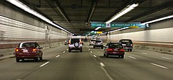
The Central Artery (officially the John F. Fitzgerald Expressway) is a section of freeway in downtown Boston, Massachusetts; it is designated as Interstate 93, US 1 and Route 3.

Contents

The original Artery, constructed in the 1950s, was named after John F. Fitzgerald; it was partly elevated and partly tunneled. Its reputation for congestion inspired the local nicknames "The Distressway," "the largest parking lot in the world", and "the other Green Monster" (the paint of the highway girders shared the same color as the left field wall at Fenway Park). [2] The Artery was significantly rerouted during a 10-year period from the mid-1990s through the early 2000s as part of the Central Artery/Tunnel Project (the "Big Dig"). The present-day Artery is almost entirely directed through the newly constructed O'Neill Tunnel, while the original Artery was demolished and replaced with the Rose Fitzgerald Kennedy Greenway, named after the daughter of John F. Fitzgerald and the mother of John F. Kennedy.

According to Massachusetts Executive Office of Transportation data, the Central Artery runs from the Massachusetts Avenue Connector just beyond Andrew Square in South Boston north to the split with U.S. Route 1 in Charlestown. [3] Along with the harbor tunnels and the Massachusetts Turnpike (I-90) from Route 128 to East Boston, it is part of the Metropolitan Highway System.

History

A 1920 plan for Boston's Central Artery, based on the West Side Elevated Highway Central Artery plan.jpg
A 1920 plan for Boston's Central Artery, based on the West Side Elevated Highway
Traffic on the former Central Artery at mid-day (Demolished in 2003) OnBostonsElevatedCentralArtery.agr.jpg
Traffic on the former Central Artery at mid-day (Demolished in 2003)

A 1926 state report on rapid transit expansion recommended the conversion of the Atlantic Avenue Elevated to an elevated highway; however, it closed in 1938 and was demolished in 1942. [4] The above-ground Artery was built in two sections in the 1950s. First was the part north of High Street and Broad Street to the Tobin Bridge, built between 1951 and 1954. [5] [ unreliable source ] Immediately, residents began to hate the new highway and the way it towered over and separated neighborhoods. Due to this opposition, the southern end of the Central Artery through the South Station area was built underground, through what became known as the Dewey Square Tunnel. Eventually, the entire highway was moved underground as part of the Big Dig Project. The Dewey Square Tunnel was the one part of the original Artery not torn down; it now serves southbound traffic. The idea of building the entire Artery underground was first floated in the 1970s emanating from the central artery depression concept developed by the Boston Transportation Planning Review. The final section through the Dewey Square Tunnel and on to the Southeast Expressway at Massachusetts Avenue opened in 1959.

The highway gradually became more and more congested as other highway projects meant to complement the Artery were canceled. These included the Inner Belt project, which would have taken through traffic off the Artery and the Massachusetts Turnpike Extension coming in from the west. The Southwest Expressway would have been the route of Interstate 95 from Canton into Boston, and would have tied into the Inner Belt of I-695.

Modifications of the above-ground Artery, which was in service until its demolition in 2003 included an additional interchange for the Massachusetts Turnpike (Mass Pike) extension that was completed in 1965, the removal of several on and off-ramps and the reworking in the late 1980s of the Tobin Bridge interchange. The Central Artery North Area (CANA) project placed the above ground ramps from the Artery underground into the City Square Tunnel in Charlestown and resulted in a reworking of the interchange at the north end, placing the northbound offramp from the east side to the west side, and eliminating dangerous weaving across the lanes of the Charlestown High Bridge, which required traffic coming from Storrow Drive and wanting to go to Charlestown to cross three lanes of traffic in only a tenth of a mile.

In September 2017, a new park was opened beneath the Central Artery adjacent to the Ink Block section of Boston's South End. The $8.5 million park has a dog park, new lighting, boardwalks, murals, and 175 parking spaces. The artwork in the public space was created by street artists from around the United States. [6]

Exit lists

Southbound Interstate 93 beneath the streets of Boston Tunnel-large.jpg
Southbound Interstate 93 beneath the streets of Boston

The original Central Artery did not have any exit numbers. These were added after the roadway was designated as I-93 in 1974. Many of these exits either do not exist or no longer resemble their original forms. Exits 19, 21, and 25 were completely eliminated. 16 and 18 (formerly exits 20 and 26) were separated northbound and southbound; 16 (former exit 20) northbound uses the old exit 19 location in South Bay, while southbound begins at the portal to the renovated Dewey Square Tunnel (now completely enclosed by Big Dig construction; 18 (former exit 26) northbound begins just shy of the tunnel exit onto the Zakim Bridge, while 18 (former exit 26) southbound is located in Charlestown's Sullivan Square near northbound exit 20 (formerly exit 28) at the portal to the double decked section of I-93 and feeds onto the Leverett Circle Connector bridge. Former exit 22 continued to exist as an offramp to Chinatown from the southbound (former northbound) Dewey Square tunnel until the ramp was closed off in 2004. 23 exists both northbound (now new exit 17) and southbound (now new exit 16B) and leads to the Scollay Square area. 17A-B southbound (formerly exit 24) now exits to Haymarket Square and MA-1A (the Callahan Tunnel). Much of the reconfiguration of on and offramps (particularly the wide separations of the ramps for exits 16 and 18) was done to move exiting traffic off the mainline of the road, reducing stress on the mainline.

Pre-Big Dig

Central Artery exit towards Oliver Street, near Two International Place, overlooking Custom House Tower, 2002 Prebigdig.jpg
Central Artery exit towards Oliver Street, near Two International Place, overlooking Custom House Tower, 2002

The entire route was in Boston, Suffolk County.

LocationmikmExitDestinationsNotes
South End South plate blue.svg
I-93.svg
South plate.svg
US 1.svg
South plate.svg
MA Route 3.svg
I-93 south / US 1 south / Route 3 south
Continues south along Southeast Expressway
18 Massachusetts AvenueRoxbury  / Andrew Square / South Bay CenterSouthbound exit and northbound entrance
19East Berkeley Street / Broadway (northbound) / Albany Street (southbound)Berkeley Street is former Dover Street
20West plate blue.svg
I-90.svg
I-90 west Downtown Crossing, Worcester
Northbound and southbound entrance; former exit for Kneeland Street pre-I-90
Chinatown 21Kneeland Street – Chinatown Southbound exit and northbound entrance; former northbound exit for Lincoln Street
Financial District 22Rail Sign.svg South Station No northbound exit
23 Atlantic Avenue / Northern Avenue / High Street / State StreetSigned southbound for High Street only
Government Center Dock Square  / Clinton StreetFormer southbound exit and northbound entrance; closed pre-Big Dig construction
24Airport Sign.svg Callahan Tunnel (Route 1A north) Logan Airport, Government Center
North End 25Rail Sign.svg Causeway Street – Haymarket Square, North Station, Government Center No northbound entrance; no southbound signage for Causeway Street
26North plate.svg
MA Route 3.svg
Rail Sign.svg Route 3 north (Storrow Drive) Cambridge, North Station
Route 3 leaves Central Artery; signed southbound for Storrow Drive only
Charles River Charlestown High Bridge
Charlestown 27North plate.svg
US 1.svg
US 1 north (Tobin Bridge) Revere
US 1 leaves Central Artery
North plate blue.svg
I-93.svg
I-93 north
Continues north along Northern Expressway
1.000 mi = 1.609 km; 1.000 km = 0.621 mi

Post-Big Dig

The entire route is in Boston, Suffolk County. Exit numbers on I-93 will eventually change to a mileage-based exit numbering as part of Massachusetts Exit Renumbering Project. [7]

LocationmikmOld exitNew exitDestinationsNotes
South End 15.34024.687South plate blue.svg
I-93.svg
South plate.svg
US 1.svg
South plate.svg
MA Route 3.svg
I-93 south / US 1 south / Route 3 south Quincy
Continues south via Southeast Expressway
2016I-90.svg I-90  / Mass Pike  Logan Airport, Worcester, South Station Northbound exit and southbound entrance; exits 134A/C on I-90
Airport Sign.svg South Station / Airport Northbound left exit and southbound left entrance. HOV restrictions from I-93 north were lifted by MassDOT. [8]
South end of the Thomas P. O'Neill Jr. Tunnel
Financial District 17.25327.76620A16ARail Sign.svg South Station Southbound exit and northbound entrance; exit 134A on I-90
20B16AI-90.svg I-90  / Mass Pike west / Albany Street [9] Southbound exit and northbound entrance; exit 134B on I-90
16.69426.86622Surface Road Chinatown Southbound entrance only
17.34027.9062317 Government Center Northbound exit and southbound entrance via North Street
17.48728.1432316BPurchase StreetSouthbound exit and entrance
Government Center 17.87428.76524A17A Government Center Southbound exit only
24B17BNorth plate.svg
MA Route 1A.svg
Airport Sign.svg Route 1A north (Callahan Tunnel) Airport
Southbound exit and northbound entrance
North end of the Thomas P. O'Neill Jr. Tunnel
Charles River Leonard P. Zakim Bunker Hill Memorial Bridge
Charlestown 17.892–
19.585
28.794–
31.519
2618North plate.svg
MA Route 3.svg
MA Route 28.svgRail Sign.svg Route 3 north / Route 28 (Storrow Drive) Leverett Circle, Cambridge, North Station [10]
Leverett Connector; signed as Storrow Drive northbound; Route 3 leaves Central Artery
18.60329.9392719North plate.svg
US 1.svg
US 1 north (Tobin Bridge) Revere
Northbound exit and southbound entrance; US 1 leaves Central Artery
North plate blue.svg
I-93.svg
I-93 north Concord, NH
Continues north via Northern Expressway
1.000 mi = 1.609 km; 1.000 km = 0.621 mi

Numbering

The elevated Central Artery around 1999, on the lower left Boston CAT Project-construction view from air.jpeg
The elevated Central Artery around 1999, on the lower left

Currently, the Artery is numbered I-93 and US 1 on the whole route, and Route 3 on all but the northernmost section—it leaves at exit 18 (former exit 26).

The Artery has had many different route numbers through its history. When first built, the section between the Sumner Tunnel and Storrow Drive received the numbers C1 and C9 (city routes of US 1 and Route 9), which were rerouted off local streets. The rest of the highway was unnumbered, despite being closely paralleled by C37 south from the Sumner Tunnel.

By 1969, I-95 was assigned to the whole Artery as part of its never-built route through Boston. The "C-prefixed" routes were removed in 1971, with Route C1 becoming part of a realigned US 1, using the Artery between Storrow Drive and the Sumner Tunnel. Additionally in 1971, Route 3 was moved from a bypass around downtown to use the Artery south of Storrow Drive and the Southeast Expressway.

In 1974, I-95 was canceled through Boston (cancelling its approach from Providence, Rhode Island through the Southwest Corridor) and was instead rerouted around the city using part of Route 128. US 1 was realigned to use the Tobin Bridge and Northeast Expressway, which had been signed as part of I-95; thus US 1 used the Artery north of Storrow Drive. The former alignment of US 1 from Storrow Drive south along the Artery to the Sumner Tunnel became an extended 1A, and I-93 was extended south from Charlestown along the Artery, Southeast Expressway and Route 128 from Braintree to Canton. In 1989, US 1 was moved off the MDC Parkways onto its current alignment along the full Artery. Route 1A was then truncated to the Sumner Tunnel interchange.

Signs put up for the new underground Artery only mention I-93, since it is the best-known designation. Older signs may mention only I-93 and US 1 or I-93 and Route 3. A 2008/2009 project to update this signage helped to clear up this potentially confusing situation.

See also

Notes

  1. Office of Transportation Planning Roads (June 2008). "MassGIS". Executive Office of Transportation.
  2. "Boston's Big Dig finally opens to public". NBC News . Associated Press. December 20, 2003. Retrieved November 13, 2008.
  3. Office of Transportation Planning (2007). "Road Inventory". Executive Office of Transportation. Archived from the original on September 27, 2006.
  4. Report on Improved Transportation Facilities in Boston. Division of Metropolitan Planning. December 1926. hdl:2027/mdp.39015049422689.
  5. "John F. Fitgerald Expressway". The Roads of Metro Boston. Self-published.
  6. Logan, Tim (September 7, 2017). "Boston gets an artsy new public space in a former no-man's land". The Boston Globe . Retrieved September 8, 2017.
  7. "I-93 Corridor". MassDOT Exit Numbering. Archived from the original on October 23, 2021. Retrieved April 13, 2021.
  8. Mass.gov. "About the Bypass Road and Logan/Route 1A Express Lane pilot project". Archived from the original on October 23, 2018. Retrieved April 13, 2021.
  9. Google (October 2013). "MA-3". Google Street View. Google. Retrieved August 23, 2014.
  10. Google (September 2013). "I-93". Google Street View. Google. Retrieved August 23, 2014.

Related Research Articles

<span class="mw-page-title-main">Big Dig</span> 1991–2007 megaproject in Boston, MA, US

The Central Artery/Tunnel Project, commonly known as the Big Dig, was a megaproject in Boston that rerouted the Central Artery of Interstate 93 (I-93), the chief highway through the heart of the city, into the 1.5-mile (2.4 km) tunnel named the Thomas P. O'Neill Jr. Tunnel. The project also included the construction of the Ted Williams Tunnel, the Leonard P. Zakim Bunker Hill Memorial Bridge over the Charles River, and the Rose Kennedy Greenway in the space vacated by the previous I-93 elevated roadway. Initially, the plan was also to include a rail connection between Boston's two major train terminals. Planning began in 1982; the construction work was carried out between 1991 and 2006; and the project concluded on December 31, 2007, when the partnership between the program manager and the Massachusetts Turnpike Authority ended.

<span class="mw-page-title-main">Leonard P. Zakim Bunker Hill Memorial Bridge</span> Cable-stayed bridge completed 2003 across the Charles River in Boston, United States

The Leonard P. ZakimBunker Hill Memorial Bridge is a cable-stayed bridge completed in 2003 across the Charles River in Boston, Massachusetts. It is a replacement for the Charlestown High Bridge, an older truss bridge constructed in the 1950s.

<span class="mw-page-title-main">Interstate 93</span> Interstate Highway in New England

Interstate 93 (I-93) is an Interstate Highway in the New England states of Massachusetts, New Hampshire, and Vermont in the United States. Spanning approximately 190 miles (310 km) along a north–south axis, it is one of three primary Interstate Highways located entirely within New England; the other two are I-89 and I-91. The largest cities along the route are Boston, Massachusetts, and Manchester, New Hampshire; it also travels through the New Hampshire state capital of Concord.

<span class="mw-page-title-main">Massachusetts Turnpike</span> Toll road and Interstate Highway in Massachusetts, United States

The Massachusetts Turnpike is a toll highway in the US state of Massachusetts that is maintained by the Massachusetts Department of Transportation (MassDOT). The turnpike begins at the New York state line in West Stockbridge, linking with the Berkshire Connector portion of the New York State Thruway. Spanning 138 miles (222 km) along an east–west axis, the turnpike constitutes the Massachusetts section of Interstate 90 (I-90). The turnpike is the longest Interstate Highway in Massachusetts, while I-90, in full, is the longest Interstate Highway in the United States.

<span class="mw-page-title-main">Dewey Square Tunnel</span>

The Dewey Square Tunnel in Boston, Massachusetts, is part of Interstate 93, running under the heart of the city's financial district, including Dewey Square. Built in 1959, it was part of Boston's Central Artery freeway construction project of the 1950s. Known to locals as the South Station Tunnel, the Dewey Square Tunnel is of cut-and-cover design, and originally was six lanes wide, with no breakdown lanes.

<span class="mw-page-title-main">Charlestown High Bridge</span> Bridge in Boston, Massachusetts

The Charlestown High Bridge spanned the Charles River in Boston, Massachusetts and was part of I-93/US 1 at the north end of the Central Artery.

<span class="mw-page-title-main">Massachusetts Route 1A</span> North-south state highway in Massachusetts, US

Route 1A is a north–south state highway in Massachusetts. It is an alternate route to U.S. 1 with three signed sections and two unsigned sections where the highway is concurrent with its parent. Due to the reconfiguration of tunnel interchanges brought on by the completion of the Big Dig, Route 1A is discontinuous in the downtown Boston area. Vehicles entering Downtown Boston via the Sumner Tunnel must take I-93 north to the exit for Government Center and make a U-turn to access the entrance ramp to I-93 south and vice versa.

<span class="mw-page-title-main">Ted Williams Tunnel</span> Tunnel in Boston

The Ted Williams Tunnel is a highway tunnel in Boston, Massachusetts. The third in the city to travel under Boston Harbor, with the Sumner Tunnel and the Callahan Tunnel, it carries the final segment of Interstate 90 from South Boston towards its eastern terminus at Route 1A in East Boston, slightly beyond Logan International Airport. The tunnel is named after the Boston Red Sox baseball legend and U.S. Marine Aviation veteran Ted Williams.

<span class="mw-page-title-main">Callahan Tunnel</span> Tunnel in Boston

The Lieutenant William F. Callahan Jr. Tunnel is one of four tunnels, and one of three road tunnels, beneath Boston Harbor in Boston, Massachusetts. It carries motor vehicles from the North End to Logan International Airport and Route 1A in East Boston. Ordinarily, this tunnel is only used to carry traffic out of the city, and with the completion of the Big Dig it only collects traffic from I-93 southbound and downtown Boston; northbound traffic uses the Ted Williams Tunnel. As of 2016, a toll of $1.50 is charged for non-commercial two-axle vehicles with a Massachusetts E-ZPass, while non-Massachusetts E-ZPass holders are charged $1.75. Vehicles without E-ZPass are charged $2.05 through MassDOT's Pay By Plate MA program. For residents of certain Boston ZIP codes, a discount is in effect using an E-ZPass transponder, costing $0.20.

<span class="mw-page-title-main">Sumner Tunnel</span>

The Sumner Tunnel is a road tunnel in Boston, Massachusetts, United States. It carries traffic under Boston Harbor in one direction, from Logan International Airport and Route 1A in East Boston. The tunnel originally deposited traffic at the west side of the North End, but with the completion of the Big Dig, it was modified to have two exits. One exit connects to I-93 northbound and downtown Boston near Haymarket Station. The other exit connects to Storrow Drive and Nashua St., connecting Cambridge via Route 28. Traffic headed for I-93 southbound and the Massachusetts Turnpike (I-90) westbound is normally routed to the Ted Williams Tunnel.

<span class="mw-page-title-main">Interstate 695 (Massachusetts)</span>

Interstate 695 was a planned six-lane auxiliary Interstate Highway in Boston, Massachusetts, that would have run through parts of Boston, Brookline, Cambridge, and Somerville.

<span class="mw-page-title-main">Atlantic Avenue (Boston)</span>

Atlantic Avenue is a street in downtown Boston, Massachusetts, partly serving as a frontage road for the underground Central Artery (I-93) and partly running along the Boston Harbor. It has a long history, with several relocations along the way.

<span class="mw-page-title-main">Rhode Island Route 146</span> State highway in Providence County, Rhode Island, US

Route 146 is a limited-access road in the U.S. state of Rhode Island, maintained by the Rhode Island Department of Transportation (RIDOT). Spanning approximately 16 miles (26 km) along a northwest–southeast axis, it links the cities of Providence, Woonsocket, and Worcester, Massachusetts.

<span class="mw-page-title-main">Massachusetts Route 3</span> Highway in Massachusetts

Route 3 is a state-numbered route in the U.S. state of Massachusetts, maintained by the Massachusetts Department of Transportation (MassDOT). Spanning approximately 56 miles (90 km) along a north–south axis, it is inventoried with U.S. Route 3 as a single route by the state. The state-numbered Route 3 travels from Bourne in the south to Cambridge in the north, while US 3 continues from Cambridge and crosses the New Hampshire state line in Tyngsborough. Mileposts on US 3 continue from those on the state-numbered Route 3.

<span class="mw-page-title-main">Massachusetts Route 28</span> Highway in Massachusetts

Route 28 is a 151.93-mile-long (244.51 km) nominally south–north state highway in the U.S. state of Massachusetts, running from the town of Eastham via Boston to the New Hampshire state line in Methuen. Following the route from its nominally southern end, Route 28 initially heads south to the town of Chatham then turns west to follow along the south shore of Cape Cod. In Falmouth, Route 28 turns north and continues through the western part of Plymouth County and the eastern part of Norfolk County; it then passes through downtown Boston before heading north via Lawrence to the New Hampshire state line, where it continues as New Hampshire Route 28.

<span class="mw-page-title-main">Interstate 95 in Massachusetts</span> Highway in Massachusetts, United States

Interstate 95 (I-95) is a part of the Interstate Highway System that parallels the East Coast of the United States from Miami, Florida, in the south to Houlton, Maine, in the north. In the US state of Massachusetts, it spans 92 miles (148 km) along a north–south axis. It is the third-longest Interstate Highway in Massachusetts, behind I-90 and I-495, while I-95 in full is the longest north–south Interstate and sixth-longest Interstate Highway in the US.

<span class="mw-page-title-main">O'Neill Tunnel</span> Highway tunnel in Boston, Massachusetts

The Thomas P. "Tip" O'Neill Jr. Tunnel is a highway tunnel built as part of the Big Dig in Boston, Massachusetts. It carries the Central Artery underneath downtown Boston, and is numbered as Interstate 93 (I-93), U.S. Route 1 (US 1), and Route 3. It roughly follows the route of the old elevated Central Artery, though the northbound entrance, at the corner of Kneeland Street and Atlantic Avenue, is somewhat east of the southbound exit to allow for a reconfigured interchange with the Massachusetts Turnpike. It runs from the Zakim Bunker Hill Bridge at its north portal—barely 165 feet (50 m) east of the TD Garden sports facility's eastern corner—to Boston's Chinatown at its south portal. The tunnel is named for Tip O'Neill, former Speaker of the United States House of Representatives, whose constituency included several of the surrounding communities in Metro Boston.

<span class="mw-page-title-main">U.S. Route 1 in Massachusetts</span> Section of U.S. Route in Massachusetts, United States

U.S. Route 1 (US 1) is a major north–south U.S. Route in the U.S. state of Massachusetts, traveling through Essex, Middlesex, Suffolk, Norfolk, and Bristol counties. The portion of US 1 south of Boston is also known as the Boston–Providence Turnpike, Washington Street, or the Norfolk and Bristol Turnpike, and portions north of Boston are known as the Northeast Expressway and the Newburyport Turnpike.

<span class="mw-page-title-main">Leverett Circle Connector Bridge</span> Bridge in Massachusetts to Somerville, Massachusetts

The Leverett Circle Connector Bridge is a highway bridge over the Charles River, carrying two lanes each of northbound and southbound traffic. It connects to Interstate 93 (I-93) in Somerville, Massachusetts at the northern end and splits at the southern end, providing direct access to both Storrow Drive and Leverett Circle in Boston. Going northbound, there is also a fork which provides access to the City Square Tunnel under Charlestown to proceed on U.S. Route 1 (US 1) northbound via the Tobin Bridge.

<span class="mw-page-title-main">Leverett Circle</span>

Leverett Circle is an intersection in Boston, Massachusetts, United States. Completely rebuilt during the Big Dig, it is no longer a rotary. It marks the confluence of Storrow Drive, Charles River Dam Road, Nashua Street, Charles Street, and Martha Road.

References

Template:Attached KML/Central Artery
KML is from Wikidata