The Big Dig was a megaproject in Boston that rerouted the then elevated Central Artery of Interstate 93 that cut across Boston into the O'Neill Tunnel and built the Ted Williams Tunnel to extend Interstate 90 to Logan International Airport. Those two projects were the origin of the official name, the Central Artery/Tunnel Project. Additionally, the project constructed the Zakim Bunker Hill Bridge over the Charles River, created the Rose Kennedy Greenway in the space vacated by the previous I-93 elevated roadway, and funded more than a dozen projects to improve the region's public transportation system. Planning for the project began in 1982; the construction work was carried out between 1991 and 2006; and the project concluded on December 31, 2007. The project's general contractor was Bechtel and Parsons Brinckerhoff was the engineer, who worked as a consortium, both overseen by the Massachusetts Highway Department.

The Leonard P. ZakimBunker Hill Memorial Bridge is a cable-stayed bridge completed in 2003 across the Charles River in Boston, Massachusetts. It is a replacement for the Charlestown High Bridge, an older truss bridge constructed in the 1950s.

Interstate 93 (I-93) is an Interstate Highway in the New England states of Massachusetts, New Hampshire, and Vermont in the United States. Spanning approximately 190 miles (310 km) along a north–south axis, it is one of three primary Interstate Highways located entirely within New England; the other two are I-89 and I-91. The largest cities along the route are Boston, and Manchester, New Hampshire; it also travels through the New Hampshire state capital of Concord.

Leonard Paul Zakim was a Jewish American religious and civil rights leader in Boston. Zakim died in 1999 after a five-year battle with bone-marrow cancer. Boston's Leonard P. Zakim Bunker Hill Bridge was named in his honor.

The Charlestown High Bridge spanned the Charles River in Boston, Massachusetts and was part of I-93/US 1 at the north end of the Central Artery.

Route 1A is a north–south state highway in Massachusetts, United States. It is an alternate route to U.S. 1 with three signed sections and two unsigned sections where the highway is concurrent with its parent. Due to the reconfiguration of tunnel interchanges brought on by the completion of the Big Dig, Route 1A is discontinuous in the downtown Boston area. Vehicles entering Downtown Boston via the Sumner Tunnel must take I-93 north to the exit for Government Center and make a U-turn to access the entrance ramp to I-93 south and vice versa.
The Ted Williams Tunnel is a highway tunnel in Boston, Massachusetts. The third in the city to travel under Boston Harbor, with the Sumner Tunnel and the Callahan Tunnel, it carries the final segment of Interstate 90 from South Boston towards its eastern terminus at Route 1A in East Boston, slightly beyond Logan International Airport. The tunnel is named after the Boston Red Sox baseball legend Ted Williams.

The Lieutenant William F. Callahan Jr. Tunnel is one of four tunnels, and one of three road tunnels, beneath Boston Harbor in Boston, Massachusetts. It carries motor vehicles from the North End to Logan International Airport and Route 1A in East Boston. Ordinarily, this tunnel is only used to carry traffic out of the city, and with the completion of the Big Dig it only collects traffic from I-93 southbound and downtown Boston; northbound traffic uses the Ted Williams Tunnel. As of 2016, a toll of $1.50 is charged for non-commercial two-axle vehicles with a Massachusetts E-ZPass, while non-Massachusetts E-ZPass holders are charged $1.75. Vehicles without E-ZPass are charged $2.05 through MassDOT's Pay By Plate MA program. For residents of certain Boston ZIP codes, a discount is in effect using an E-ZPass transponder, costing $0.20.

The Sumner Tunnel is a road tunnel in Boston, Massachusetts, United States. It carries traffic under Boston Harbor in one direction, from Logan International Airport and Route 1A in East Boston. The tunnel originally deposited traffic at the west side of the North End, but with the completion of the Big Dig, it was modified to have two exits. One exit connects to I-93 northbound and downtown Boston near Haymarket Station. The other exit connects to Storrow Drive and Nashua St., connecting Cambridge via Route 28. Traffic headed for I-93 southbound and the Massachusetts Turnpike (I-90) westbound is normally routed to the Ted Williams Tunnel. It is managed by the Massachusetts Department of Transportation.

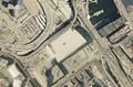
Science Park station is an elevated light rail station on the Massachusetts Bay Transportation Authority (MBTA) Green Line in Boston, Massachusetts, United States. The station is located at the Boston end of the Charles River Dam Bridge at Leverett Circle. It is at the southeast end of the Lechmere Viaduct, which carries the Green Line over the Charles River. The station is named for the nearby Boston Museum of Science. With 873 daily boardings by a FY 2019 count, Science Park is the least-used fare-controlled station on the Green Line, and the second-lowest on the MBTA subway system after Suffolk Downs.

Interstate 695 was a planned six-lane auxiliary Interstate Highway in Boston, Massachusetts, that would have run through parts of Boston, Brookline, Cambridge, and Somerville.
The Central Artery is a section of freeway in downtown Boston, Massachusetts; it is designated as Interstate 93, US 1 and Route 3.

The Boston University Bridge, originally the Cottage Farm Bridge and commonly referred to as the BU Bridge, is a steel truss through arch bridge with a suspended deck carrying Route 2 over the Charles River, connecting the Boston University campus to Cambridge, Massachusetts.

Route 3 is a state-numbered route in the U.S. state of Massachusetts, maintained by the Massachusetts Department of Transportation (MassDOT). Spanning approximately 56 miles (90 km) along a north–south axis, it is inventoried with U.S. Route 3 as a single route by the state. The state-numbered Route 3 travels from Bourne in the south to Cambridge in the north, while US 3 continues from Cambridge and crosses the New Hampshire state line in Tyngsborough. Mileposts on US 3 continue from those on the state-numbered Route 3.

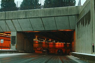
The Thomas P. "Tip" O'Neill Jr. Tunnel is a highway tunnel built as part of the Big Dig in Boston, Massachusetts. It carries the Central Artery underneath downtown Boston, and is numbered as Interstate 93 (I-93), U.S. Route 1 (US 1), and Route 3. It roughly follows the route of the old elevated Central Artery, though the northbound entrance, at the corner of Kneeland Street and Atlantic Avenue, is somewhat east of the southbound exit to allow for a reconfigured interchange with the Massachusetts Turnpike. It runs from the Zakim Bunker Hill Bridge at its north portal—barely 165 feet (50 m) east of the TD Garden sports facility's eastern corner—to Boston's Chinatown at its south portal. The tunnel is named for Tip O'Neill, former Speaker of the United States House of Representatives, whose constituency included several of the surrounding communities in Metro Boston.

Storrow Drive, officially James Jackson Storrow Memorial Drive, is a major crosstown parkway in Boston, Massachusetts, running east–west along the southern bank of the Charles River. It is restricted to cars; trucks and buses are not permitted on it, while pedestrian access is available via walking paths on the Charles River side of the road. Boston drivers use the route for quick access to downtown locations.

U.S. Route 1 (US 1) is a major north–south U.S. Route in the state of Massachusetts, traveling through Essex, Middlesex, Suffolk, Norfolk, and Bristol counties. The portion of US 1 south of Boston is also known as the Boston–Providence Turnpike, Washington Street, or the Norfolk and Bristol Turnpike, and portions north of Boston are known as the Northeast Expressway and the Newburyport Turnpike.

Leverett Circle is an intersection in Boston, Massachusetts, United States. Completely rebuilt during the Big Dig, it is no longer a rotary. It marks the confluence of Storrow Drive, Charles River Dam Road, Nashua Street, Charles Street, and Martha Road.

Paul Revere Park is a five-acre (2.0 ha) park located on the Charles River in Charlestown, Massachusetts. The park was the first park to open along the "Lost Half Mile" of the Charles River as mitigation for the taking of planned parkland for the construction of the Big Dig. The park runs along the Charles River between the Freedom Trail on North Washington Street and the Leonard P. Zakim Bunker Hill Memorial Bridge. The park features a large oval-shaped lawn, an informal performance area, and a playground.

Boston Sand and Gravel is a supplier of ready-to-pour concrete, concrete blocks, sand, and crushed stone, with operations and subsidiaries around eastern Massachusetts and New Hampshire in the United States.