
Chelsea is a city in Suffolk County, Massachusetts, United States, directly across the Mystic River from Boston. The 2020 census reported Chelsea as having a population of 40,787, thereby making it the second most densely populated city in Massachusetts, behind Somerville. With a total area of 2.46 square miles (6.4 km2), Chelsea is the smallest city in Massachusetts in terms of total area. It is the city with the second-highest percentage of Latino residents in Massachusetts, behind Lawrence.

Roxbury is a neighborhood within the City of Boston, Massachusetts, United States.
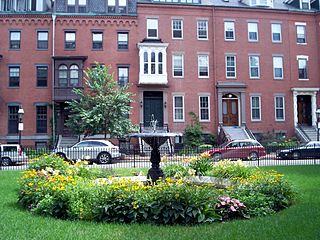
The South End is a neighborhood in Boston, Massachusetts, United States which is bordered by Back Bay, Chinatown, and Roxbury. It is distinguished from other neighborhoods by its Victorian-style houses and the parks in and around the area. The South End is the largest intact Victorian row-house district in the country, covering over 300 acres (120 ha). It has eleven residential parks. In 1973, the South End was listed on the National Register of Historic Places. Much of the neighborhood was originally marshlands in Boston's South Bay. After it was filled in, construction began in 1849.

Dorchester is a neighborhood comprising more than 6 square miles (16 km2) in the City of Boston, Massachusetts, United States. Originally, Dorchester was a separate town, founded by Puritans who emigrated in 1630 from Dorchester, Dorset, England, to the Massachusetts Bay Colony. This dissolved municipality, Boston's largest neighborhood by far, is often divided by city planners in order to create two planning areas roughly equivalent in size and population to other Boston neighborhoods.

Davis Square is a major intersection in the northwestern section of Somerville, Massachusetts, United States, where several streets meet: Holland Street, Dover Street, Day Street, Elm Street, Highland Avenue, and College Avenue. The name is often used to refer to the West Somerville neighborhood surrounding the square as well.
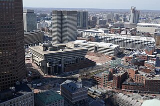
Government Center is an area in downtown Boston, centered on City Hall Plaza. Formerly the site of Scollay Square, it is now the location of Boston City Hall, courthouses, state and federal office buildings, and a major MBTA subway station, also called Government Center. Its development was controversial, as the project displaced thousands of residents and razed several hundred homes and businesses.

Beacon Hill is a historic neighborhood in Boston, Massachusetts, United States, and the hill upon which the Massachusetts State House resides. The term "Beacon Hill" is used locally as a metonym to refer to the state government or the legislature itself, much like Washington, D.C.'s Capitol Hill does at the federal level.

Roslindale is a primarily residential neighborhood of Boston, Massachusetts, United States, bordered by Jamaica Plain, Hyde Park, West Roxbury and Mattapan. It is served by an MBTA Commuter Rail line, several MBTA bus lines and the MBTA Orange Line in nearby Jamaica Plain. Roslindale has its own branch of the Boston Public Library, the neighborhood is covered by Boston Police District E-5 in West Roxbury, Boston EMS Ambulance 17 is stationed in Roslindale, and the Boston Fire Department has a station on Canterbury Street which houses Ladder 16, Engine 53 & District Chief 12. Roslindale's original Engine Company 45, was deactivated on April 10, 1981, due to budget cuts. Roslindale was once called the "garden suburb" of Boston. The portion of the Arnold Arboretum south of Bussey Street is located in Roslindale.

Downtown Crossing is a shopping district within downtown Boston, Massachusetts, located east of Boston Common, west of the Financial District, south of Government Center, and north of Chinatown and the old Combat Zone. It features large department stores as well as restaurants, souvenir sellers, general retail establishments, and street vendors. The Downtown Crossing MBTA station lies in the center of the district.

Downtown Brooklyn is the third largest central business district in New York City, and is located in the northwestern section of the borough of Brooklyn. The neighborhood is known for its office and residential buildings, such as the Williamsburgh Savings Bank Tower and the MetroTech Center office complex.

Hyde Park is the southernmost neighborhood of Boston, Massachusetts, United States. Situated 7.9 miles south of downtown Boston, it is home to a diverse range of people, housing types and social groups. It is an urban location with suburban characteristics.

Newtonville is one of the thirteen villages within the city of Newton in Middlesex County, Massachusetts, United States.

Central Square is a section of the neighborhood of East Boston in Boston, Massachusetts, United States. The square begins at the intersection of Bennington Street and Meridian Street, continues up Meridian to its intersection with White Street, and includes all the area to the left. The square's intersecting streets also include Border, Saratoga, and Eutaw Street. It is within close proximity of the entrance to the Sumner Tunnel, which motorists take to downtown Boston.

Long Wharf is a historic American pier in Boston, Massachusetts, built between 1710 and 1721. It once extended from State Street nearly a half-mile into Boston Harbor; today, the much-shortened wharf functions as a dock for passenger ferries and sightseeing boats.
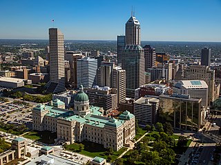
Downtown Indianapolis is a neighborhood area and the central business district of Indianapolis, Indiana, United States. Downtown is bordered by Interstate 65, Interstate 70, and the White River, and is situated near the geographic center of Marion County. Downtown has grown from the original 1821 town plat—often referred to as the Mile Square—to encompass a broader geographic area of central Indianapolis, containing several smaller historic neighborhoods.
North Quincy is a neighborhood of Quincy, Massachusetts. It is separated from the city of Boston by the Neponset River, and borders the Quincy neighborhoods of Squantum, Montclair and Wollaston. It contains the smaller neighborhoods of Atlantic and Norfolk Downs, as well as much of Wollaston Beach.
Park Square in downtown Boston, Massachusetts, is bounded by Stuart, Charles Street South, Boylston, and Arlington Streets.

Uphams Corner, or Upham's Corner, is a commercial center in Dorchester, the largest neighborhood of Boston, Massachusetts. The intersection of Dudley Street/Stoughton Street and Columbia Road is the heart of Uphams Corner, and one of Dorchester's main business districts.
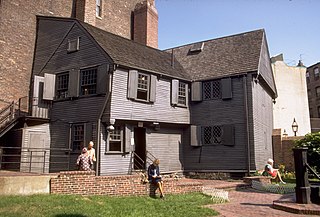
The architecture of Boston is a robust combination of old and new architecture. As one of the oldest cities in North America, Boston, Massachusetts has accumulated buildings and structures ranging from the 17th-century to the present day, having evolved from a small port town to a large cosmopolitan center for education, industry, finance, and technology. The city is known for its granite buildings stemming from its early days. It is also known for being one of the origins of Federal Architecture.

