The Chinatown–International District of Seattle, Washington is the center of the city's Asian American community. Within the district are the three neighborhoods known as Chinatown, Japantown and Little Saigon, named for the concentration of businesses owned by people of Chinese, Japanese and Vietnamese descent, respectively. The geographic area also once included Manilatown.
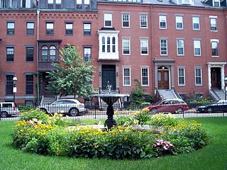
The South End is a neighborhood in Boston, Massachusetts, United States which is bordered by Back Bay, Chinatown, and Roxbury. It is distinguished from other neighborhoods by its Victorian-style houses and the parks in and around the area. The South End is the largest intact Victorian row-house district in the country, covering over 300 acres (120 ha). It has eleven residential parks. In 1973, the South End was listed on the National Register of Historic Places. Much of the neighborhood was originally marshlands in Boston's South Bay. After it was filled in, construction began in 1849.
Back Bay is an officially recognized neighborhood of Boston, Massachusetts, built on reclaimed land in the Charles River basin. Construction began in 1859, as the demand for luxury housing exceeded the availability in the city at the time, and the area was fully built by around 1900. It is most famous for its rows of Victorian brownstone homes—considered one of the best preserved examples of 19th-century urban design in the United States—as well as numerous architecturally significant individual buildings, and cultural institutions such as the Boston Public Library, and Boston Architectural College. Initially conceived as a residential-only area, commercial buildings were permitted from around 1890, and Back Bay now features many office buildings, including the John Hancock Tower, Boston's tallest skyscraper. It is also considered a fashionable shopping destination and home to several major hotels.

Downtown Crossing is a shopping district within downtown Boston, Massachusetts, located east of Boston Common, west of the Financial District, south of Government Center, and north of Chinatown and the old Combat Zone. It features large department stores as well as restaurants, souvenir sellers, general retail establishments, and street vendors. The Downtown Crossing MBTA station lies in the center of the district.

Springfield is a historic neighborhood of Jacksonville, Florida, United States, located to the north of downtown. Established in 1869, it experienced its greatest growth from the early 1880s through the 1920s. The Springfield Historic District is listed in the National Register of Historic Places, and contains some of the city's best examples of 19th and early 20th century architecture.

Chinatown, Boston is a neighborhood located in downtown Boston, Massachusetts, United States. It is the only surviving historic ethnic Chinese enclave in New England since the demise of the Chinatowns in Providence, Rhode Island and Portland, Maine after the 1950s. Because of the high population of Asians and Asian Americans living in this area of Boston, there is an abundance of Chinese and Vietnamese restaurants located in Chinatown. It is one of the most densely populated residential areas in Boston and serves as the largest center of its East Asian and Southeast Asian cultural life.

Boston's diverse neighborhoods serve as a political and cultural organizing mechanism. The City of Boston's Office of Neighborhood Services has designated 23 Neighborhoods in the city:

The Historic Third Ward is a historic warehouse district located in downtown Milwaukee, Wisconsin. This Milwaukee neighborhood is listed on the National Register of Historic Places. Today, the Third Ward is home to over 450 businesses and maintains a strong position within the retail and professional service community in Milwaukee as a showcase of a mixed-use district. The neighborhood's renaissance is anchored by many specialty shops, restaurants, art galleries and theatre groups, creative businesses and condos. It is home to the Milwaukee Institute of Art and Design (MIAD), and the Broadway Theatre Center. The Ward is adjacent to the Henry Maier Festival Park, home to Summerfest. The neighborhood is bounded by the Milwaukee River to the west and south, E. Clybourn Street to the north, and Lake Michigan to the east.

Bay Village is the smallest officially recognized neighborhood of Boston, Massachusetts, United States. As of 2010, its population was approximately 1,312 residents living in 837 housing units, most of which are small brick rowhouses.

Old Town Chinatown is the official Chinatown of the northwest section of Portland, Oregon. The Willamette River forms its eastern boundary, separating it from the Lloyd District and the Kerns and Buckman neighborhoods. It includes the Portland Skidmore/Old Town Historic District and the Portland New Chinatown/Japantown Historic District, which are listed on the National Register of Historic Places. It has been referred to as the "skid row" of Portland.

Long Wharf is a historic American pier in Boston, Massachusetts, built between 1710 and 1721. It once extended from State Street nearly a half-mile into Boston Harbor; today, the much-shortened wharf functions as a dock for passenger ferries and sightseeing boats.
The South Bay Interchange is a massive interchange in downtown Boston, Massachusetts, in the US. The interchange consists of Interstate 90, the Mass Pike Extension, and the Interstate 93 concurrency with US 1 and MA 3 south of the Thomas P. O'Neill Jr. Tunnel.

The New Bedford Historic District is a National Historic Landmark District in New Bedford, Massachusetts, United States, west of the community's waterfront. During the 19th century, when the city was the center of the American whaling industry, this was its downtown. After its decline in the early and mid-20th century, through the efforts of local activist groups the district has since been preserved and restored to appear much as it was during that period.

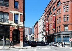
The Beach-Knapp District encompasses a collection of six 19th-century buildings in the Chinatown neighborhood of Boston, Massachusetts. It is centered at the corner of Beach and Knapp Streets, and includes three buildings on the south side of Beach Street, and three on the east side of Knapp. The buildings encapsulate the transition of the area from a predominantly residential area to a mixed residential-light industrial area in the 19th century. At 5 and 7 Knapp Street stand two Greek Revival residential structures, both built in the 1830s. The four story Renaissaince Revival building at 7-15 Beach Street was built c. 1885, and was historically used as a hotel. The other three buildings, 17-23 Beach, 25-29 Beach, and 9-23 Knapp, are all commercial buildings dating between 1885 and 1906; two of them were designed by Shepley, Rutan and Coolidge.

The Lower Roxbury Historic District is a historic district encompassing an isolated pocket of 1890s mixed residential-commercial property in the lower Roxbury neighborhood of Boston, Massachusetts. Bounded by Tremont, Columbus, and Burke Streets and St. Cyprian's Place, the area contains a well-kept collection of architect designed buildings that survived late 20th-century urban redevelopment. The district was added to the National Register of Historic Places in 1994.

This is a list of the National Register of Historic Places listings in Detroit, Michigan.

The Franklin Block is a historic commercial building in Brockton, Massachusetts. The three-story brick Romanesque Revival-style building was built in 1888. Its construction marked the high point in the economic recovery of the city's Campello neighborhood, which had been devastated by fire in 1853, and is one of two 19th-century buildings in the area. The building was listed on the National Register of Historic Places in 1989.

The Greenwich Avenue Historic District is a historic district representing the commercial and civic historical development of the downtown area of the town of Greenwich, Connecticut. The district was listed on the National Register of Historic Places on August 31, 1989. Included in the district is the Greenwich Municipal Center Historic District, which was listed on the National Register the year before for the classical revival style municipal buildings in the core of Downtown. Most of the commercial buildings in the district fall into three broad styles, reflecting the period in which they were built: Italianate, Georgian Revival, and Commercial style. The district is linear and runs north–south along the entire length of Greenwich Avenue, the main thoroughfare of Downtown Greenwich, between U.S. Route 1 and the New Haven Line railroad tracks.

The Chinatown Historic District is a neighborhood of Honolulu, Hawaii, known for its Chinese American community. It is one of the oldest Chinatowns in the United States.

The Canal Street–Clark Street Neighborhood Historic District encompasses a compact 19th-century working-class neighborhood of Brattleboro, Vermont. Most of its buildings are modest vernacular wood-frame buildings, erected between 1830 and 1935; there are a few apartment blocks, and one church. The district was listed on the National Register of Historic Places in 1993.