Boston is the capital of the U.S. state of Massachusetts and the largest city in New England. It is home to over 580 completed high-rises,[1] 73 of which stand taller than 300 feet (91 m) as of 2026. Boston's skyline is by far the largest in New England, and the city has the second most skyscrapers taller than 492 ft (150 m) in the Northeastern United States, after New York City. The tallest building in Boston is the 62-story 200 Clarendon, better known as the John Hancock Tower; the office skyscraper rises 790 ft (241 m) in the Back Bay district, southwest of Downtown Boston.
The history of skyscrapers in Boston began early with the completion of the 13-story Ames Building in 1893. The Greek Revival style Custom House Tower, which was Boston's tallest building from 1915 to 1964, was among the first skyscrapers outside of New York City. Boston went through a major building boom from the 1960s to the early 1990s, resulting in the construction of over 30 buildings taller than 300 ft (91 m), including the John Hancock Tower and the city's second-tallest building, the Prudential Tower. At the time of the Prudential Tower's completion in 1964, it stood as the tallest building in North America outside of New York City.[2]
After a hiatus in the 1990s, high-rise development resumed in the 2000s, with a higher share residential or mixed-use buildings. Since 2016, several major projects have significantly altered the city's skyline, including four skyscrapers taller than 600 ft (183 m): Millennium Tower in 2016, One Dalton in 2020, and both Winthrop Center and One Congress in 2023. A fifth, South Station Tower, is under construction atop Boston's historic South Station, and was completed in 2025. Around the same period, the West End neighborhood has seen an influx in high-rises, such as The Hub on Causeway. The regeneration of the Seaport District since the 2000s has added many new high-rises to the former industrial area, although none of them surpass 300 ft in height.
Although Boston's skyscrapers are concentrated in the Financial District in downtown, its three tallest buildings—John Hancock Tower, Prudential Tower, and One Dalton—are located in Back Bay. Boston's skyline is shaped by the roughly 2.5 mile unofficial High Spine urban corridor,[3] bypassing surrounding low-rise residential areas like Beacon Hill and the North End. In addition to the Seaport District southeast of downtown, the skyline has stretched westwards towards Fenway–Kenmore beginning in the 2010s. In the wider metropolitan area, there is an ongoing high-rise boom in neighboring Cambridge, as well as in Somerville to a lesser extent. Regulations on building shadows and the proximity of Logan International Airport to downtown have limited the height of skyscrapers in downtown Boston to below 800 ft (244 m).[4] Boston's tallest public viewing deck is View Boston, located on the upper floors of the Prudential Tower, and provides 360 degree views of the city.[5]
History
Number of buildings by height in Boston by the end of each year. Click on the legend to toggle a specific height on or off. View chart definition.
Cityscape
A panorama of the Boston skyline as viewed from Prospect Hill in 2025, with the Financial District on the left and Back Bay to the right
Map of tallest buildings
The map below shows the location of buildings taller than 300 feet (91.4 m) in Boston. Each marker is colored by the decade of the building's completion.
This list ranks completed buildings in Boston that stand at least 300feet (91m) tall as of 2026, based on standard height measurement. This includes spires and other architectural details, but not including antenna masts. The "Year" column indicates the year when a building was completed. Buildings tied in height are sorted by year of completion, and then alphabetically.
Was the tallest building in Boston upon completion
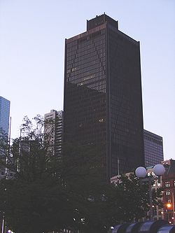
Tallest building in Boston, Massachusetts, and New England since 1976. Commonly known as John Hancock Tower, its original name (for John Hancock Financial), but now legally 200 Clarendon Street or Hancock Place.[6] Tallest building in Boston completed in the 1970s[7][8][9]
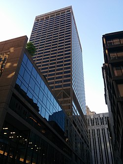
View Boston, the highest observation deck in New England, is located on the building's 50th, 51st, and 52nd floors. Tallest building in Boston completed in the 1960s. Was the tallest building in Boston before being surpassed by the John Hancock Tower in 1976.[10][2][11]
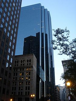
Tallest residential building in Boston and New England.[12][13] Tallest building in Boston completed in the 2020s. Mixed-use residential and hotel building.
Tallest building in Boston outside of Back Bay. Second tallest building in Boston completed in the 2020s. Mixed-use residential and office building.[14][15]
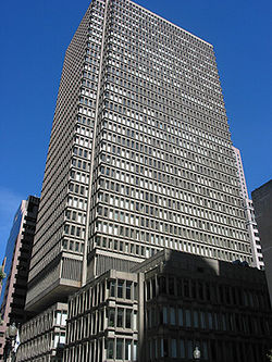
Tallest all-hotel building in Boston. Tallest building in Boston completed in the 1910s. Was the tallest building in Boston before being surpassed by the Prudential Tower.[44][45][46]
↑ This building's height is not available from the CTBUH. The stated height was determined using Google Earth and is accurate to the nearest meter (approximately three feet)
Tallest building in Cambridge. Also known as Site 4 at Kendall Square, 290 Main Street, or MIT Site 4. Mixed-use residential, educational, and office building.[121]
Tallest under construction or proposed
Under construction
The following table includes buildings under construction in Boston that are expected to be at least 300 ft (91 m) tall as of 2026, based on standard height measurement.
For most of Boston's earlier years, the tallest buildings in the city were churches with their steeples. The first skyscraper in the city is generally considered the Ames Building, completed in 1893.[124] However, since the 13-story building did not surpass the steeple of the Church of the Covenant,[125] it never became a city record holder. The first skyscraper to have the distinction of being Boston's tallest building was the Custom House Tower, completed in 1915.[45]
This page is based on this Wikipedia article Text is available under the CC BY-SA 4.0 license; additional terms may apply. Images, videos and audio are available under their respective licenses.