
The Loop, one of Chicago's 77 designated community areas, is the central business district of the city and is the main section of Downtown Chicago. Home to Chicago's commercial core, it is the second largest commercial business district in North America after Midtown Manhattan in New York City, and contains the headquarters and regional offices of several global and national businesses, retail establishments, restaurants, hotels, and theaters, as well as many of Chicago's most famous attractions. It is home to Chicago's City Hall, the seat of Cook County, and numerous offices of other levels of government and consulates of foreign nations. The intersection of State Street and Madison Street is the origin point for the address system on Chicago's street grid. Most of Grant Park's 319 acres are in the eastern section of the community area. The Loop community area is bounded on the north and west by the Chicago River, on the east by Lake Michigan, and on the south by Roosevelt Road.

Downtown is the largest central business district in the city of Houston and the largest in the state of Texas, located near the geographic center of the metropolitan area at the confluence of Interstate 10, Interstate 45, and Interstate 69. The 1.84-square-mile (4.8 km2) district, enclosed by the aforementioned highways, contains the original townsite of Houston at the confluence of Buffalo Bayou and White Oak Bayou, a point known as Allen's Landing. Downtown has been the city's preeminent commercial district since its founding in 1836.

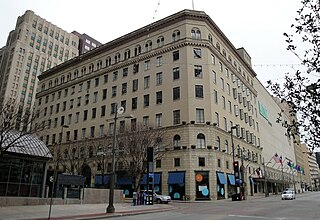
Water Tower Place is a large urban, mixed-use development comprising a 758,000 sq ft (70,400 m2) shopping mall in a 74-story skyscraper in Chicago, Illinois, United States. The mall is located at 835 North Michigan Avenue, along the Magnificent Mile. It is named after the nearby Chicago Water Tower, and is owned by affiliates of Brookfield Property Partners.
Baychester is a neighborhood geographically located in the northeast part of the Bronx, New York City. Its boundaries are East 222nd Street to the northeast, the New England Thruway (I-95) to the east, Gun Hill Road to the southwest, and Boston Road to the northwest. Eastchester Road is the primary thoroughfare through Baychester.

New Center is a commercial and residential district located in Detroit, Michigan, adjacent to Midtown, one mile (1.6 km) north of the Cultural Center, and approximately three miles (5 km) north of Downtown. The area is centered just west of the intersection of Woodward Avenue and Grand Boulevard, and is bounded by, and includes the Virginia Park Historic District on the north, the Edsel Ford Freeway (I-94) on the south, John R Street on the east and the Lodge Freeway on the west. New Center, and the surrounding areas north of I-94, are sometimes seen as coterminous with the North End, while in fact separate districts.

The Mercantile National Bank Building is a 31-story, 159.4 m (523 ft) skyscraper at 1800 Main Street in the Main Street district of downtown Dallas, Texas. It is the former home of the Mercantile National Bank, which later became MCorp Bank. The design of the skyscraper features Moderne styling from the Art Deco era and was designed by Walter W. Ahlschlager. The building has a series of setbacks that is crowned by an ornamental four-sided clock along with a decorative weather spire. The Merc was the main element of a four-building complex that eventually spanned a full city block.
Near Northside is a historic neighborhood located in Northside, Houston, Texas. Near Northside is primarily occupied by people of Hispanic descent.

One Lincoln Street, also known as State Street Financial Center, is a skyscraper in Boston, Massachusetts on the edge of both the Financial District and neighborhood of Chinatown. Completed in 2003, it was built using Boston Redevelopment Authority (BRA) guidelines. Standing at 503 feet tall, One Lincoln Street is the 21st-tallest building in Boston. The skyscraper has a five-level underground garage that provides parking for 900 cars. It contains 1 million square feet of office space.

Minneapolis Public Schools (MPS) or Special School District Number 1 is a public school district serving students in pre-kindergarten through twelfth grade from Minneapolis, Minnesota. Minneapolis Public Schools enrolls 36,370 students in public primary and secondary schools. The district administers about one hundred public schools including forty-five elementary schools, seven middle schools, seven high schools, eight special education schools, eight alternative schools, nineteen contract alternative schools, and five charter schools. With authority granted by the state legislature, the school board makes policy, selects the superintendent, and oversees the district's budget, curriculum, personnel, and facilities. Students speak ninety different languages at home and most school communications are printed in English, Hmong, Spanish, and Somali.
The Titche–Goettinger Building is one of Dallas' original broad-front department stores located along St. Paul Street between Main and Elm Street in downtown Dallas, Texas (USA). The structure currently houses apartments, retail space, and the Universities Center at Dallas. It is listed on the National Register of Historic Places both individually and as a contributing property in the Dallas Downtown Historic District and is a Dallas Landmark as part of the Harwood Street Historic District. It is also located across the street from Main Street Garden Park.

Downtown San Antonio is the central business district of San Antonio, Texas and the urban core of Greater San Antonio, a metropolitan area with nearly 2.5 million people.

The Club Quarters Hotel is a 16-story, 61.6 m (202 ft) Beaux-Arts high-rise at 710 Fannin Street in downtown Houston, Texas, United States. The building is listed on the National Register of Historic Places as the Texas State Hotel.
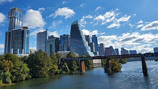
Downtown Austin is the central business district of Austin, Texas, United States. The area of the district is bound by Lamar Boulevard to the west, Martin Luther King Jr. Boulevard to the north, Interstate 35 to the east, and Lady Bird Lake to the south.

The Mercer West Tower is a 30-story, 401 ft (122 m) high-rise condominium building located on Sage Street in the uptown district of Houston, Texas, United States. The building is the first of two towers that are part of the Mercer Towers complex. The tower is the 45th tallest building in the city.

One Park Place is a 501 ft tall apartment building located adjacent to Discovery Green park in downtown Houston, Texas. Completed by The Finger Companies in May 2009, the building has 340 units on 30 floors with a total height of 501 feet (153 m) and 37 floors.

The Second Brazer Building is an historic office building at 25-29 State Street in Boston, Massachusetts, with a locally significant early Beaux Arts design.

Franklinton Middle School is a public school for secondary education located in Franklinton, North Carolina, United States. It occupies the same building as did Franklinton High School from 1924 though 2011 before a new high school building was constructed outside of town in order to ease overcrowding. This school currently serves grades 6 through 8 for students residing in the Franklinton area. The building was closed for renovations from late 2011 through much of 2013. Middle school students attended Cedar Creek Middle School in nearby Youngsville during that time. It reopened as Franklinton Middle School for classes on August 26, 2013.

Rockwood is a neighborhood in Spokane, Washington. It is located on the south side of the city to the southeast of Downtown Spokane and expanding southeasterly from close to the city center. Its proximity to downtown makes it one of Spokane's older neighborhoods, with mature trees lining most of its streets. Due to its location on the hill leading up from the Spokane River Valley, the street grid breaks down in many places around Rockwood. The most notable of these is along the winding Rockwood Boulevard, which was designed by the Olmsted Brothers and weaves its way from the northwesternmost corner of the neighborhood through the center and across to the eastern border, highlighting the basalt bluffs and other natural topography.

Emerson/Garfield is a neighborhood in Spokane, Washington. It is located immediately north of Downtown Spokane's North Bank and extends out into the inner northwestern portion of the city. Emerson/Garfield is a diverse neighborhood with residential, commercial and civic zones all bordering one another, with density ranging from single-family homes to multi-use buildings. Due to its location in the central area of Spokane, Emerson/Garfield is criss-crossed by numerous arterials and thoroughfares. Along those main roads are numerous commercial and retail districts of importance to both the neighborhood and city as a whole.
Balboa/South Indian Trail is a neighborhood in Spokane, Washington located on the northwestern side of the city. The neighborhood is largely composed of single-family residential areas that were developed after being annexed into the city in the 1950s. The neighborhood is situated on tableland above a steep bluff rising from the Spokane River to the west, that then rises up a more developed bluff towards Five Mile Prairie which is located above the neighborhood to the north and east.

