


Below is a table of the twenty tallest buildings in Saint Paul, Minnesota. Since 1987 the tallest building has been the 471-foot Wells Fargo Place.
Below is a table of the twenty tallest buildings in Saint Paul, Minnesota. Since 1987 the tallest building has been the 471-foot Wells Fargo Place.
| Rank | Name | Height ft / m | Floors | Year | Notes |
|---|---|---|---|---|---|
| 1 | Wells Fargo Place | 471 / 144 | 37 | 1987 | Tallest building in St. Paul since its completion in 1987. |
| 2 | Jackson Tower | 460 / 135 | 46 | 1986 | Tallest building in St. Paul from 1986 to 1987, and also has the most floors in St. Paul. |
| 3 | First National Bank Building | 417 / 127 | 32 | 1931 | Tallest building in St. Paul from 1931 to 1986. |
| 4 | Kellogg Square Apartments | 366 / 112 | 32 | 1972 | |
| 5 | The Pointe of St. Paul | 340 / 104 | 34 | 1988 | |
| 6 | US Bank Center | 338 / 103 | 26 | 1975 | |
| 7 | City Walk Condominiums & Parking | 332 / 101 | 27 | 1983 | |
| 8 | Travelers Building | 330 / 101 | 17 | 1991 | |
| 9 | Bremer Tower | 328 / 100 | 27 | 1980 | |
| 10 | The 400 Building | 327 / 100 | 21 | 1982 | |
| 11 | Landmark Towers | 327 / 100 | 25 | 1983 | |
| 12 | Sibley Tower | 314 / 96 | 33 | 1986 | |
| 13 | Cathedral of Saint Paul | 306 / 93 | 2 | 1915 | Tallest building in St. Paul from 1915 to 1931. |
| 14 | UBS Plaza | 305 / 93 | 25 | 1980 | |
| 15 | Ecolab Corporate Center | 305 / 93 | 22 | 1968 | |
| 16 | Eugene McCarthy U. S. Post Office | 274 / 84 | 15 | 1934 | |
| 17 | Crowne Plaza St. Paul-Riverfront | 268 / 82 | 23 | 1966 | |
| 18 | St. Paul City Hall | 261 / 80 | 21 | 1932 | |
| 19 | The 401 Building | 256 / 78 | 13 | 2000 | Tallest building in St. Paul constructed in the 21st century. |
| 20 | Ecolab University Center | 254 / 77 | 17 | 1973 | |
| 21 | Skyline Tower | 240 / 73 | 24 | 1972 | |
| 22 | Pioneer Building | ? / ? | 17 | 1889 | |
| Name | Height ft / m | Floors | Year | Status | Notes |
|---|---|---|---|---|---|
| AECOM Riversedge Tower 4 | TBD | TBD | 2026 | Proposed | [1] |
| AECOM Riversedge Tower 3 | 325 | 20 | 2023 | Proposed | [2] |
| AECOM Riversedge Tower 2 | 302 | 28 | 2022 | Proposed | [3] |
| AECOM Riversedge Tower 1 | 247 | 23 | 2022 | Proposed | [4] |
Ramsey County is a county located in the U.S. state of Minnesota. As of the 2020 census, the population was 552,352, making it the second-most populous county in Minnesota. Its county seat and largest city is Saint Paul, the state capital and the twin city of Minneapolis. The county was founded in 1849 and is named for Alexander Ramsey, the first governor of the Minnesota Territory.

The Minnesota Historical Society (MNHS) is a nonprofit educational and cultural institution dedicated to preserving the history of the U.S. state of Minnesota. It was founded by the territorial legislature in 1849, almost a decade before statehood. The Society is named in the Minnesota Constitution. It is headquartered in the Minnesota History Center in downtown Saint Paul.

St. Paul Downtown Airport, also known as Holman Field, is an airport just across the Mississippi River from downtown Saint Paul, Minnesota. It is one of several reliever airports in the Twin Cities operated by the Metropolitan Airports Commission. The airport has three runways and serves aircraft operated by corporations in the local area, a flight training school and the Minnesota Army National Guard aviation unit, as well as transient general aviation aircraft.

Cray Plaza, located in the Lowertown neighborhood of Saint Paul, Minnesota, United States, provides space for working, living, eating, and recreating on one square city block opened in 1986.

This is a list of sites in Minnesota which are included in the National Register of Historic Places. There are more than 1,700 properties and historic districts listed on the NRHP; each of Minnesota's 87 counties has at least 2 listings. Twenty-two sites are also National Historic Landmarks.

The Mississippi National River and Recreation Area is a 72-mile (116 km) and 54,000-acre (22,000 ha) protected corridor along the Mississippi River through Minneapolis–Saint Paul in the U.S. state of Minnesota, from the cities of Dayton and Ramsey to just downstream of Hastings. This stretch of the upper Mississippi River includes natural, historical, recreational, cultural, scenic, scientific, and economic resources of national significance. This area is the only national park site dedicated exclusively to the Mississippi River. The Mississippi National River and Recreation Area is sometimes abbreviated as MNRRA or MISS, the four-letter code the National Park Service assigned to the area. The Mississippi National River and Recreation Area is classified as one of four national rivers in the United States, and despite its name is technically not one of the 40 national recreation areas.
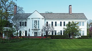
Eastcliff is a 20-room house overlooking the Mississippi River in St. Paul, Minnesota, United States, which serves as the official residence of the president of the University of Minnesota system. It was first built in 1922 by local lumber magnate Edward Brooks Sr. and donated to the university by the Brooks family in 1958, beginning its service as the president's official residence in 1960 when O. Meredith Wilson took the position. In 2000, the home was added to the National Register of Historic Places.

The Minneapolis Armory is a historic event center and former National Guard armory located in downtown Minneapolis, Minnesota, United States. Built by the Public Works Administration in 1936, the building was occupied by several Army and Naval Militia units of the Minnesota National Guard from its opening until 1985. The building is listed on the National Register of Historic Places.

The Alexander Ramsey House is a historic house museum in Saint Paul, Minnesota, United States; the former residence of Alexander Ramsey, who served as the first governor of Minnesota Territory and the second governor of the state of Minnesota. It was listed on the National Register of Historic Places in 1969. It is also a contributing property to the Irvine Park Historic District.

Shepard Road and Warner Road are the names given to a four-lane road running along the banks of the Mississippi River in Saint Paul, Minnesota. Shepard Road runs from the southwestern boundary of the county to downtown Saint Paul. From downtown east the road is known as Warner Road. It runs to a junction with US Highways 61 and 10.

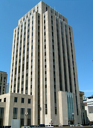
The Saint Paul City Hall and Ramsey County Courthouse, located at 15 Kellogg Boulevard West in Saint Paul, Ramsey County, in the U.S. state of Minnesota, is a twenty-story Art Deco skyscraper completed in 1932. Built during the Great Depression—a period of high unemployment and falling prices—the building's four-million-dollar budget was underspent, resulting in higher quality materials and craftsmanship than initially expected.

Saint Paul, Minnesota, consists of 17 officially defined city districts or neighborhoods.

This is a list of the National Register of Historic Places listings in Dakota County, Minnesota. It is intended to be a complete list of the properties and districts on the National Register of Historic Places in Dakota County, Minnesota, United States. Dakota County is located in the southeastern part of the U.S. state of Minnesota, bounded on the northeast side by the Upper Mississippi River and on the northwest by the Minnesota River. The locations of National Register properties and districts for which the latitude and longitude coordinates are included below, may be seen in an online map.
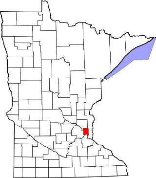
This is a complete list of National Register of Historic Places listings in Ramsey County, Minnesota. It is intended to be a complete list of the properties and districts on the National Register of Historic Places in Ramsey County, Minnesota, United States. The locations of National Register properties and districts for which the latitude and longitude coordinates are included below, may be seen in an online map.

Downtown Saint Paul is the central business district of Saint Paul, Minnesota, United States. Its boundaries are the Mississippi River to the south, University Avenue to the north, US 52 to the east, and Kellogg Boulevard to the west. It is bounded by the Dayton's Bluff, Summit-University, West Seventh, Frogtown, West Side, and Payne-Phalen neighborhoods. The West Side neighborhood is on the other side of the river, and can be accessed via the Robert Street Bridge or the Wabasha Street Bridge. Interstate 35E and Interstate 94 run through the north side of the neighborhood, providing a separation between the Minnesota State Capitol and other state government buildings with the rest of downtown.

Skyline Tower is a large low-income high rise apartment complex in Saint Paul, Minnesota, United States. The building is also often called St. Anthony Tower, or 1247 St. Anthony. At 240 feet (73 m) it is the largest single HUD-subsidized building in Minnesota, and the 22nd-tallest building in Saint Paul. With over 500 units it is the largest single-building subsidized housing complex in the U.S. west of Chicago. The building is run by CommonBond Communities, the largest developer or owner of affordable rental housing in Minnesota. The nonprofit bought the building in 2000 with the help of U.S. Bank. The building was previously owned by Skyline Towers Co and managed by Sentinel Management Co.

The Vision of Peace is a statue in the three-story memorial concourse lobby along the Fourth Street entrance of the Saint Paul City Hall and Ramsey County Courthouse in Saint Paul, Minnesota, United States. The memorial to the Minnesota 20th-century war dead was created by Swedish sculptor Carl Milles, who named it Indian God of Peace. He drew on memories of a Native American ceremony he witnessed in Ponca City, Oklahoma. Although there is no connection between Native American spirituality and his own vision, Milles depicted five Native Americans seated around a fire holding sacred pipes. Emerging from the smoke of those pipes is a "god of peace" which Milles imagined speaking to "all the world.”
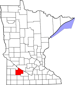
This is a list of the National Register of Historic Places listings in Redwood County, Minnesota. It is intended to be a complete list of the properties and districts on the National Register of Historic Places in Redwood County, Minnesota, United States. The locations of National Register properties and districts for which the latitude and longitude coordinates are included below, may be seen in an online map.

The Riverfront is an urban development in Downtown Miami, Florida, United States. The complex is located on the north bank of the Miami River in Miami's Central Business District. The complex contains three main towers, "Mint" and "The Ivy" and "Wind." The taller of the three, Mint, is currently the 6th-tallest building in Miami and Florida. It has 55 floors and rises 631 feet (192 m).