The Central Artery/Tunnel Project, commonly known as the Big Dig, was a megaproject in Boston that rerouted the Central Artery of Interstate 93 (I-93), the chief highway through the heart of the city, into the 1.5-mile (2.4 km) tunnel named the Thomas P. O'Neill Jr. Tunnel. The project also included the construction of the Ted Williams Tunnel, the Leonard P. Zakim Bunker Hill Memorial Bridge over the Charles River, and the Rose Kennedy Greenway in the space vacated by the previous I-93 elevated roadway. Initially, the plan was also to include a rail connection between Boston's two major train terminals. Planning began in 1982; the construction work was carried out between 1991 and 2006; and the project concluded on December 31, 2007, when the partnership between the program manager and the Massachusetts Turnpike Authority ended.

The Massachusetts Bay Transportation Authority is the public agency responsible for operating most public transportation services in Greater Boston, Massachusetts. The MBTA transit network includes the MBTA subway with three metro lines, two light rail lines, and a five-line bus rapid transit system ; MBTA bus local and express service; the twelve-line MBTA Commuter Rail system, and several ferry routes. In 2022, the system had a ridership of 216,329,500, or about 759,800 per weekday as of the first quarter of 2023, of which the rapid transit lines averaged 263,500 and the light rail lines 91,300, making it the fourth-busiest rapid transit system and the third-busiest light rail system in the United States. As of the first quarter of 2023, average weekday ridership of the commuter rail system was 81,800, making it the fifth-busiest commuter rail system in the U.S.

The Blue Line is a rapid transit line in the Greater Boston metropolitan area, one of four rapid transit lines operated by the Massachusetts Bay Transportation Authority (MBTA). It runs from Bowdoin station in downtown Boston under Boston Harbor to East Boston and Revere on the inner North Shore, where it terminates at Wonderland. The stop at Airport Station, by way of a free shuttle bus, is one of two rapid transit connections to Logan International Airport. In 1967, during a systemwide rebranding, the line was assigned the blue color because it passes under the Boston Harbor. With an end-to-end travel time of less than twenty minutes, the Blue Line is the shortest of Boston's heavy-rail lines and the only line to have both third rail and overhead catenary sections.

The Silver Line is a system of bus routes in Boston and Chelsea, Massachusetts, operated by the Massachusetts Bay Transportation Authority (MBTA). It is operated as part of the MBTA bus system, but branded as bus rapid transit (BRT) as part of the MBTA subway system. Six routes are operated as part of two disconnected corridors. As of 2019, weekday ridership on the Silver Line was 39,000.

Airport station is a rapid transit station in Boston, Massachusetts. It serves the MBTA Blue Line and the SL3 branch of the Silver Line. It is located in East Boston under the interchange between Interstate 90 and Massachusetts Route 1A. The station provides one of two mass transit connections to the nearby Logan International Airport, as well as serving local residents in East Boston. Shuttle buses connect the station with the airport terminals and other facilities.

Charles/MGH station is a rapid transit station on the MBTA Red Line, elevated above Charles Circle on the east end of the Longfellow Bridge in the West End neighborhood of Boston, Massachusetts. The station is named for Charles Circle and the adjacent Massachusetts General Hospital (MGH) campus. It has two side platforms, with a glass-walled headhouse structure inside Charles Circle. Charles/MGH station is fully accessible.

Wellington station is a Massachusetts Bay Transportation Authority (MBTA) Orange Line rapid transit station in Medford, Massachusetts, near the border of Everett. It is located on the Revere Beach Parkway, slightly east of its intersection with Route 28. Wellington functions as a park and ride with more than 1,300 spaces, and a bus hub with 10 routes terminating at the station. The Station Landing development, connected to the station by an overhead walkway, includes residential and retail buildings and additional parking. Wellington Carhouse, the primary repair and maintenance facility for the Orange Line, is located adjacent to the station.
The Southwest Corridor or Southwest Expressway was a project designed to bring an eight-lane highway into the City of Boston from a direction southwesterly of downtown. It was supposed to connect with Interstate 95 (I-95) at Route 128. As originally designed, it would have followed the right of way of the former Penn Central/New Haven Railroad mainline running from Readville, north through Roslindale, Forest Hills and Jamaica Plain, where it would have met the also-cancelled I-695. The 50-foot-wide median for the uncompleted "Southwest Expressway" would have carried the southwest stretch of the MBTA Orange Line within it, replacing the Washington Street Elevated railway's 1901/1909-built elevated railbed. Another highway, the four-lane South End Bypass, was proposed to run along the railroad corridor between I-695 in Roxbury and I-90 near Back Bay.

The North–South Rail Link (NSRL) is a proposed rail tunnel, or pair of tunnels, that would connect North Station and South Station in downtown Boston, Massachusetts. The project would build new underground stations near the existing stations, connect them with about 1.5 miles (2.4 km) of tunnels, and add other tunnels to link up with existing surface tracks.

Lechmere station is a Massachusetts Bay Transportation Authority (MBTA) Green Line light rail station in Lechmere Square in East Cambridge, Massachusetts. It is located on the east side of Monsignor O'Brien Highway near First Street, adjacent to the NorthPoint development. The accessible elevated station has a single island platform, with headhouses at both ends. It opened on March 21, 2022, as part of the Green Line Extension (GLX). Lechmere station is served by Green Line D branch and E branch service.
The Urban Ring was a proposed project of the Massachusetts Bay Transportation Authority and the Massachusetts Department of Transportation, to develop new public transportation routes that would provide improved circumferential connections among many existing transit lines that project radially from downtown Boston. The Urban Ring Corridor is located roughly one to two miles from downtown Boston, passing through the Massachusetts cities of Boston, Chelsea, Everett, Medford, Somerville, Cambridge, and Brookline. The project was expected to convert 41,500 car trips to transit trips daily.
The Massachusetts Department of Transportation (MassDOT) oversees roads, public transit, aeronautics, and transportation licensing and registration in the US state of Massachusetts. It was created on November 1, 2009, by the 186th Session of the Massachusetts General Court upon enactment of the 2009 Transportation Reform Act.
The history of the Massachusetts Bay Transportation Authority (MBTA) and its predecessors spans two centuries, starting with one of the oldest railroads in the United States. Development of mass transportation both followed existing economic and population patterns, and helped shape those patterns.

Bellingham Square station is a Massachusetts Bay Transportation Authority (MBTA) Silver Line bus rapid transit (BRT) station located near Bellingham Square slightly north of downtown Chelsea, Massachusetts. The station has two accessible side platforms for buses on the SL3 route. The Boston and Maine Railroad and predecessor Eastern Railroad served Chelsea station at the same location from the mid-1850s to 1958. The MBTA opened Chelsea station on the Newburyport/Rockport Line in 1985. Prior to its 2010 cancellation, the Urban Ring Project planned for a circumferential BRT line with a stop at Mystic Mall. Planning continued for the Chelsea segment; a Silver Line extension to Mystic Mall was announced in 2013. Construction began in 2015, and SL3 service to the renamed Bellingham Square station began on April 21, 2018. Commuter rail service moved to the newly constructed Chelsea station on November 15, 2021.
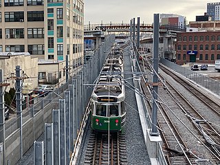
The Green Line Extension (GLX) was a construction project to extend the Massachusetts Bay Transportation Authority (MBTA) Green Line light rail system northwest into Somerville and Medford, two inner suburbs of Boston, Massachusetts. The project opened in two phases in 2022 at a total cost of $2.28 billion. Total ridership on the 4.3-mile (6.9 km) extension is estimated to reach 45,000 one-way trips per day in 2030.

South Coast Rail is a project to build a new southern line of the MBTA Commuter Rail system along several abandoned and freight-only rail lines. The line has been planned to restore passenger rail service between Boston and the cities of Taunton, Fall River, and New Bedford, via the towns of Berkley, and Freetown, on the south coast of Massachusetts. It would restore passenger service to some of the southern lines of the former Old Colony Railroad and the New York, New Haven and Hartford Railroad.

Boston University Central station is a surface-level light rail station on the MBTA Green Line B branch, located the center median of Commonwealth Avenue west of St. Marys Street in Boston, Massachusetts, surrounded by the Boston University campus. It consists of two side platforms, which serve the B branch's two tracks.

Union Square station is a light rail station on the Massachusetts Bay Transportation Authority (MBTA) Green Line located in the Union Square neighborhood of southeastern Somerville, Massachusetts. The accessible terminal station has a single island platform serving the two tracks of the Union Square Branch, which parallels the Fitchburg Line. It opened on March 21, 2022, as part of the Green Line Extension (GLX), which added two northern branches to the Green Line.

Box District station is a bus rapid transit station on the Massachusetts Bay Transportation Authority (MBTA) Silver Line system, located in Chelsea, Massachusetts. The accessible station has two side platforms under an arched canopy, with street access from Broadway and from Highland Street. Plans for the Urban Ring Project called for a busway along the former Grand Junction Branch, but without a station in the Box District neighborhood. After the Urban Ring was cancelled in 2010, new plans for a busway with a Box District stop were announced in 2013. Construction began in 2015, with route SL3 service beginning on April 21, 2018.

Eastern Avenue station is a bus rapid transit station on the Massachusetts Bay Transportation Authority (MBTA) Silver Line system, located in Chelsea, Massachusetts near Chelsea Creek. The accessible station has two side platforms, with street access from Eastern Avenue and Central Avenue. Plans for the Urban Ring Project called for a busway along the former Grand Junction Branch, but with a station further north at Griffin Way. After the Urban Ring was cancelled in 2010, new plans for a busway with an Eastern Avenue stop were announced in 2013. Construction began in 2015, with route SL3 service beginning on April 21, 2018.


