
Hanover Street is located in the North End of Boston, Massachusetts. [1]
Hanover Street is located in the North End of Boston, Massachusetts. [1]

The street is one of the oldest in Boston, and was originally a Native American path, allowing access to the shore, prior to the first European settlement. In the 17th century, the street was called Orange Tree Lane. In 1708, the street was renamed after the British House of Hanover, heirs to the throne under the Act of Settlement 1701. In 1824, North Street and the former Middle Street became part of Hanover. [2] In the 1950s, the block of Hanover Street between Cross Street and Blackstone Street was demolished to make way for the construction of the Central Artery. [3] This block was reopened in 2004 when the elevated Central Artery was removed as part of the Big Dig [4] and replaced by the Rose Kennedy Greenway. In the 1960s the southern section of Hanover street, from Congress Street to Court Street (now Cambridge Street), was demolished to make way for the construction of Government Center. [5] Hanover Street is now home to many businesses, cafes, churches, and Italian restaurants. The portion of the street between the Rose Kennedy Greenway and Union Street is closed on Friday and Saturday each week for the Haymarket open-air market.

The North End is a neighborhood of Boston, Massachusetts, United States. It has the distinction of being the city's oldest residential community, where Europeans have continuously inhabited since it was colonized in the 1630s. Though small, only 0.36 square miles (0.93 km2), the neighborhood has nearly one hundred establishments and a variety of tourist attractions. It is known for its Italian American population and Italian-themed restaurants. The district is a pending Boston Landmark.
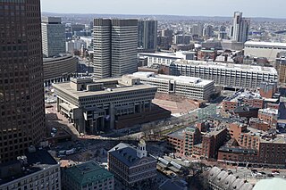
Government Center is an area in downtown Boston, centered on City Hall Plaza. Formerly the site of Scollay Square, it is now the location of Boston City Hall, courthouses, state and federal office buildings, and a major MBTA subway station, also called Government Center. Its development was controversial, as the project displaced thousands of residents and razed several hundred homes and businesses.

Scollay Square was a vibrant city square in downtown Boston, Massachusetts. It was named for William Scollay, a prominent local developer and militia officer who bought a landmark four-story merchant building at the intersection of the Cambridge and Court Streets in the year 1795. Local citizens began to refer to this intersection as Scollay's Square, and, in 1838, the city officially memorialized the intersection as the Scollay Square. Early on, the area was a busy center of commerce, including daguerreotypist (photographer) Josiah Johnson Hawes (1808–1901) and Dr. William Thomas Green Morton, the first dentist to use ether as an anaesthetic.

The Rose Fitzgerald Kennedy Greenway is a linear park located in several Downtown Boston neighborhoods. It consists of landscaped gardens, promenades, plazas, fountains, art, and specialty lighting systems that stretch over one mile through Chinatown, the Financial District, the Waterfront, and North End neighborhoods. Officially opened in October 2008, the 17-acre Greenway sits on land created from demolition of the John F. Fitzgerald Expressway under the Big Dig.
Dewey Square is a square in downtown Boston, Massachusetts which lies at the intersection of Atlantic Avenue, Summer Street, Federal Street, Purchase Street and the John F. Kennedy Surface Road, with the Central Artery (I-93) passing underneath in the Dewey Square Tunnel and Big Dig. South Station is on the southeast corner of the square, with Amtrak and MBTA Commuter Rail services, as well as Red Line subway trains and Silver Line bus rapid transit underneath.
The Central Artery is a section of freeway in downtown Boston, Massachusetts; it is designated as Interstate 93, US 1 and Route 3.

Haymarket Square is the historic name of a former town square in Boston, located between the North End, Government Center, the Bulfinch Triangle, and the West End. The square was a well-known feature of Boston from the mid-19th century to the mid-20th century, when the buildings around it were demolished to make way for the Central Artery and Government Center. The Haymarket produce market continues to operate at a location near the historic site of the square. The Haymarket MBTA station extends under the former site of the square.

Washington Street is a street originating in downtown Boston, Massachusetts that extends southwestward to the Massachusetts–Rhode Island state line. The majority of it was built as the Norfolk and Bristol Turnpike in the early 19th century. It is the longest street in Boston, and it remains one of the longest streets in the Commonwealth of Massachusetts.

New Chardon Street is a street in downtown Boston, Massachusetts, United States, north of Government Center. It begins at Cambridge Street at Bowdoin Square, across from Bowdoin Street. The two-way street continues east across Congress Street, ending at Haymarket Square with access to the Sumner and Callahan Tunnels and the Central Artery, as well as local access to Washington Street North and the Surface Artery.

Tremont Street is a major thoroughfare in Boston, Massachusetts.

Downtown Boston is the central business district of Boston, Massachusetts, United States. The city of Boston was founded in 1630. The largest of the city's commercial districts, Downtown is the location of many corporate or regional headquarters; city, county, state and federal government facilities; and many of Boston's tourist attractions. Similar to other central business districts in the U.S., Downtown has recently undergone a transformation that included the construction of new condos and lofts, renovation of historic buildings, and arrival of new residents and businesses. It is represented in the Boston City Council by District 2's Bill Linehan.

State Street in Boston, Massachusetts, is one of the oldest streets in the city. Located in the financial district, it is the site of some historic landmarks, such as Long Wharf, the Old State House and the Boston Custom House.

Court Street is located in the Financial District of Boston, Massachusetts. Prior to 1788, it was called Prison Lane (1634–1708) and then Queen Street (1708–1788). In the 19th century it extended beyond its current length, to Bowdoin Square. In the 1960s most of Court Street was demolished to make way for the construction of Government Center. The remaining street extends a few blocks, near the Old State House on State Street.

Winter Street in Boston, Massachusetts is located between Tremont Street and Washington Street, near the Common. It is currently a pedestrian zone. Prior to 1708, it was called Blott's Lane and then Bannister's Lane.. It was also known at times as "Winer Street."

Congress Street in Boston, Massachusetts, is located in the Financial District and South Boston. It was first named in 1800. It was extended in 1854 as far as Atlantic Avenue, and in 1874 across Fort Point Channel into South Boston. Today's Congress Street consists of several segments of streets, previously named Atkinson's Street, Dalton Street, Gray's Alley, Leverett's Lane, Quaker Lane, and Shrimpton's Lane.

North Street in the North End of Boston, Massachusetts extends from Congress Street to Commercial Street. It runs past Dock Square, Faneuil Hall, Quincy Market, the Rose Kennedy Greenway, and North Square. It was first named in 1852, and consists of segments of streets formerly named Ann, Fish, Ship, Drawbridge, and Conduit Streets.

Cornhill was a street in Boston, Massachusetts, in the 18th, 19th and 20th centuries, located on the site of the current City Hall Plaza in Government Center. It was named in 1829; previously it was known as Market Street (1807–1828). In its time, it comprised a busy part of the city near Brattle Street, Court Street and Scollay Square. In the 19th century, it was the home of many bookstores and publishing companies. As of 1969, Cornhill exists as 144 feet along the edge of City Hall Plaza.

Tremont Row (1830s-1920s) in Boston, Massachusetts, was a short street that flourished in the 19th and early-20th centuries. It was located near the intersection of Court, Tremont, and Cambridge streets, in today's Government Center area. It existed until the 1920s, when it became known as Scollay Square. In 1859 the Barre Gazette newspaper described Tremont Row as "the great Dry Goods Street of Boston."

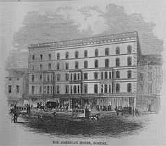
The American House was a hotel in Boston, Massachusetts, located on Hanover Street. Abraham W. Brigham, Lewis Rice (1837–1874), Henry B. Rice (1868–1888), and Allen E. Jones served as proprietors. In 1851 the building was expanded, to a design by Charles A. Alexander. In 1868 it had "the first hotel passenger elevator in Boston." By the 1860s it also had "billiard halls, telegraph office, and cafe." In the late 19th century it was described as "the headquarters of the shoe-and-leather trade" in the city. Guests of the hotel and restaurant included John Brown, Ralph Waldo Emerson, William Whitwell Greenough, Charles Savage Homer, Zadoc Long, and George Presbury Rowell. Many groups held meetings there, among them: Granite Cutters' International Association of America, Letter Carriers' Association, National Electric Light Association, and New England Shorthand Reporters' Association. The hotel closed in 1916, and re-opened under new management in 1918. It permanently closed on August 8, 1935, and the building was shortly afterwards demolished to make room for a parking lot. The John F. Kennedy Federal Building now occupies the site.

Haymarket in Boston is an open-air market on Blackstone, Hanover, and North Streets, next to the Rose Fitzgerald Kennedy Greenway between the North End and Government Center.


| Wikimedia Commons has media related to Hanover Street (Boston, Massachusetts) . |
Coordinates: 42°21′50.85″N71°03′14.14″W / 42.3641250°N 71.0539278°W
