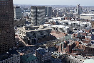
Government Center is an area in downtown Boston, centered on City Hall Plaza. Formerly the site of Scollay Square, it is now the location of Boston City Hall, courthouses, state and federal office buildings, and a major MBTA subway station, also called Government Center. Its development was controversial, as the project displaced thousands of residents and razed several hundred homes and businesses.

Faneuil Hall is a marketplace and meeting hall located near the waterfront and today's Government Center, in Boston, Massachusetts. Opened in 1742, it was the site of several speeches by Samuel Adams, James Otis, and others encouraging independence from Great Britain. It is now part of Boston National Historical Park and a well-known stop on the Freedom Trail. It is sometimes referred to as "the Cradle of Liberty", though the building and location have ties to slavery.

South Station, officially The Governor Michael S. Dukakis Transportation Center at South Station, is the largest railroad station and intercity bus terminal in Greater Boston and New England's second-largest transportation center after Logan International Airport. Located at the intersection of Atlantic Avenue and Summer Street in Dewey Square, Boston, Massachusetts, the historic station building was constructed in 1899 to replace the downtown terminals of several railroads. Today, it serves as a major intermodal domestic transportation hub, with service to the Greater Boston region and the Northeastern and Midwestern United States. It is used by thousands of commuter rail and intercity rail passengers daily. Connections to the rapid transit Red Line and bus rapid transit Silver Line are made through the adjacent subway station.
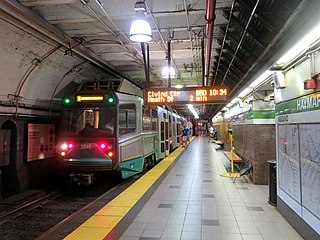
Haymarket station is an underground Massachusetts Bay Transportation Authority (MBTA) rapid transit station located at Haymarket Square in Boston, Massachusetts. It is a transfer station between the Green Line and Orange Line of the MBTA subway system, as well as a terminal for MBTA bus routes serving northern and northeastern suburbs. The two lines run parallel to each other through the station, with two side platforms for the Orange Line and a single island platform for the Green Line. The station is fully accessible.

Wellington station is a Massachusetts Bay Transportation Authority (MBTA) Orange Line rapid transit station in Medford, Massachusetts, near the border of Everett. It is located on the Revere Beach Parkway, slightly east of its intersection with Route 28. Wellington functions as a park and ride with more than 1,300 spaces, and a bus hub with 10 routes terminating at the station. The Station Landing development, connected to the station by an overhead walkway, includes residential and retail buildings and additional parking. Wellington Carhouse, the primary repair and maintenance facility for the Orange Line, is located adjacent to the station.

One Federal Street is a skyscraper in the Financial District neighborhood of Boston, Massachusetts. Completed in 1975, it is Boston's 13th-tallest building, standing 520 feet tall, and housing 38 floors. It is very close to the Rose F. Kennedy Greenway, Faneuil Hall Marketplace. Construction of the building was completed in 1976. However, it underwent renovations between 1992 and 2011. Some of the most notable tenants include: AON Service Corporation, Morgan Lewis & Bockius LLP, Credit Suisse, J.P. Morgan, Iron Mountain, Oppenheimer, and U.S. Bank.

Quincy Market is a historic building near Faneuil Hall in downtown Boston, Massachusetts. It was constructed between 1824 and 1826 and named in honor of mayor Josiah Quincy, who organized its construction without any tax or debt. The market is a designated National Historic Landmark and a designated Boston Landmark in 1996, significant as one of the largest market complexes built in the United States in the first half of the 19th century. According to the National Park Service, some of Boston's early slave auctions took place near what is now Quincy Market.

Route 128 station is a passenger rail station located at the crossing of the Northeast Corridor and Interstate 95/US Route 1/Route 128 at the eastern tip of Dedham and Westwood, Massachusetts, United States. The station is shared by Amtrak and the Massachusetts Bay Transportation Authority (MBTA). It is served by most MBTA Commuter Rail Providence/Stoughton Line trains, as well as by all Amtrak Northeast Regional and Acela intercity trains. The station building, platforms, and parking garage are all fully accessible. It is the 23rd busiest Amtrak station in the country and the fifth busiest in New England.

The Rose Fitzgerald Kennedy Greenway is a linear park located in several Downtown Boston neighborhoods. It consists of landscaped gardens, promenades, plazas, fountains, art, and specialty lighting systems that stretch over one mile through Chinatown, the Financial District, the Waterfront, and North End neighborhoods. Officially opened in October 2008, the 17-acre Greenway sits on land created from demolition of the John F. Fitzgerald Expressway as part of the Big Dig project.

Haymarket Square is the historic name of a former town square in Boston, located between the North End, Government Center, the Bulfinch Triangle, and the West End. The square was a well-known feature of Boston from the mid-19th century to the mid-20th century, when the buildings around it were demolished to make way for the Central Artery and Government Center. The Haymarket produce market continues to operate at a location near the historic site of the square. The Haymarket MBTA station extends under the former site of the square.

The Boston Planning & Development Agency (BPDA), formerly the Boston Redevelopment Authority (BRA), is a Massachusetts public agency that serves as the municipal planning and development agency for Boston, working on both housing and commercial developments.

One Lincoln Street, also known as State Street Financial Center, is a skyscraper in Boston, Massachusetts on the edge of both the Financial District and neighborhood of Chinatown. Completed in 2003, it was built using Boston Redevelopment Authority (BRA) guidelines. Standing at 503 feet tall, One Lincoln Street is the 17th-tallest building in Boston. The skyscraper has a five-level underground garage that provides parking for 900 cars. It contains 1 million square feet of office space.

One Post Office Square is a 42-floor modern skyscraper in the Financial District section of Boston, Massachusetts. The skyscraper is Boston's 12th-tallest building, standing 525 feet tall. The building has exactly 831,975 square feet of Class A office space. An attached, eight-level parking garage offers 368 parking spaces and direct access to the building's lobby. It overlooks Post Office Square Park and was designed by Jung Brannen Associates. A previous building on the site at 101 Milk Street was the headquarters of the Boston Elevated Railway until about 1919.

Boston Harborwalk is a public walkway that follows the edge of piers, wharves, beaches, and shoreline around Boston Harbor. When fully completed it will extend a distance of 47 miles (76 km) from East Boston to the Neponset River.

The Boston Museum was a proposed history museum for the city of Boston, Massachusetts. The museum had chosen a nickname, "BoMu", before it was terminated.

Morrissey Boulevard is a six-lane divided coastal road in the Dorchester neighborhood of Boston, Massachusetts. It is owned and maintained by the Massachusetts Department of Conservation and Recreation (DCR).

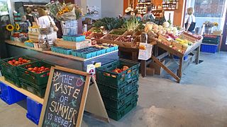
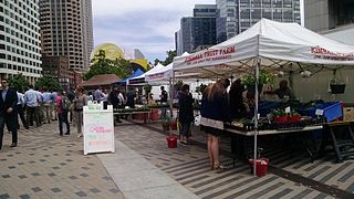
Haymarket in Boston is an open-air market on Blackstone, Hanover, and North Streets, next to the Rose Fitzgerald Kennedy Greenway between the North End and Government Center.
Bulfinch Crossing is a redevelopment project currently under construction in Downtown Boston, Massachusetts, United States. It will consist of two skyscrapers, a smaller residential tower, a low-rise office building, a hotel, and a low-rise retail building. Site preparation began in late 2015, and construction officially commenced on January 24, 2017. Construction on the residential tower completed in 2020. The high-rise office tower, One Congress, commenced construction in 2019 and topped off in July 2021; it is planned to open in 2022.

Essex Market is a food market with independent vendors at the intersection of Essex Street and Delancey Street in the Lower East Side of Manhattan, New York City. The market is known for its many local shops, including grocery stores, bakeries, butchers, seafood shops, coffee vendors, cheese shops, and spice shops. There are small restaurants that serve meals in the market, including Shopsin's. The LES Girls Club and Cuchifritos Gallery + Project Space are also included in the market.
The Parcel C protests were a community organized grassroots movement in the Chinatown of Boston, Massachusetts led by the Coalition to Protect Parcel C for Chinatown, which formed in response to the 1993 deal between Boston Redevelopment Authority (BRA) and New England Medical Center (NEMC) to create a hospital parking garage in Chinatown. The space in question, named Parcel C, is a small plot of land bordered by Oak Street, Nassau Street, May Place, and Ash Street. The surrounding areas were primarily residential, with a day care center directly adjacent to the plot, which raised health and safety concerns. The protest helped bring awareness to environmental injustice in urban cities and cultivated systems and methods for successful activism in a non-English speaking community.


