State Street (Boston)

Last updated
State Street with view of Old State House in 2010 2010 StateSt Boston.jpg
State Street with view of Old State House in 2010

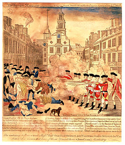
State Street is one of the oldest and most historic streets in Boston, Massachusetts. Located in the financial district, it is the site of some historic landmarks, such as Long Wharf, the Old State House and the Boston Custom House.

Contents

History

South Market Street, Boston, a stereoscopic photograph by Bierstadt Brothers South Market St., Boston, Mass, by Bierstadt Brothers.png
South Market Street, Boston, a stereoscopic photograph by Bierstadt Brothers

In 1630, the first Puritan settlers, led by John Winthrop, built their earliest houses along what is today State Street. The Puritans also originally built the meeting house for the First Church in Boston on the street across from the marketplace, which was located where the Old State House stands today. By 1636 the thoroughfare was known as Market Street. From 1708 to 1784, it was renamed 'King Street[ citation needed ] In 1770 the Boston Massacre took place in front of the Customs House. [1]

During the Revolutionary War, it assumed its current, non-royalist name. [2] In the 19th century State Street became known as Boston's primary location for banks and other financial institutions. [3]

Transportation

The Blue Line of the MBTA subway runs below State Street. Two stations have entrances on State Street: Aquarium and State. The Faneuil Hall Marketplace is also nearby. The east end of State Street is at Long Wharf, where ferries are available to several places, including the airport.

See also

Images

Related Research Articles

<span class="mw-page-title-main">Salem, Massachusetts</span> City in Massachusetts, United States

Salem is a historic coastal city in Essex County, Massachusetts, United States, located on the North Shore of Greater Boston. Continuous settlement by Europeans began in 1626 with English colonists. Salem would become one of the most significant seaports trading commodities in early American history. It is a suburb of Boston.

<span class="mw-page-title-main">John Winthrop</span> English Puritan lawyer (1588–1649)

John Winthrop was an English Puritan lawyer and one of the leading figures in founding the Massachusetts Bay Colony, the second major settlement in New England following Plymouth Colony. Winthrop led the first large wave of colonists from England in 1630 and served as governor for 12 of the colony's first 20 years. His writings and vision of the colony as a Puritan "city upon a hill" dominated New England colonial development, influencing the governments and religions of neighboring colonies in addition to those of Massachusetts.

<span class="mw-page-title-main">Winthrop, Massachusetts</span> Town in Massachusetts, United States

Winthrop is a town in Suffolk County, Massachusetts, United States. The population was 19,316 at the 2020 census. Winthrop is an ocean-side suburban community in Greater Boston situated at the north entrance to Boston Harbor, close to Logan International Airport. It is located on a peninsula, 1.6 square miles (4.2 km2) in area, connected to Revere by a narrow isthmus and to East Boston by a bridge over the harbor inlet to the Belle Isle Marsh Reservation.

<span class="mw-page-title-main">Boston Common</span> Public park in Boston, Massachusetts

The Boston Common is a public park in downtown Boston, Massachusetts. It is the oldest city park in the United States. Boston Common consists of 50 acres (20 ha) of land bounded by Tremont Street, Park Street, Beacon Street, Charles Street, and Boylston Street.

<span class="mw-page-title-main">Long Wharf (Boston)</span> United States historic place

Long Wharf is a historic American pier in Boston, Massachusetts, built between 1710 and 1721. It once extended from State Street nearly a half-mile into Boston Harbor; today, the much-shortened wharf functions as a dock for passenger ferries and sightseeing boats.

<span class="mw-page-title-main">King's Chapel Burying Ground</span> Graveyard in Boston

King's Chapel Burying Ground is a historic graveyard on Tremont Street, near its intersection with School Street, in Boston, Massachusetts. Established in 1630, it is the oldest graveyard in the city and is a site on the Freedom Trail. Despite its name, the graveyard pre-dates the adjacent King's Chapel ; it is not affiliated to that or any other church.

<span class="mw-page-title-main">First Parish Church of Dorchester</span>

First Parish Dorchester is a Unitarian Universalist church in Dorchester, Massachusetts. The congregation was founded by English Puritans who initially saw themselves as reformers rather than separatists, but increasingly intolerable conditions in England and at the urging of Reverend John White of Dorchester, Dorset, they emigrated to New England. On March 20, 1630 as they set sail from Plymouth, England on the Mary and John, the congregation wrote its founding church covenant. Nearly all of the 140 ship passengers originated in the West Country counties of Somerset, Dorset and Devon. In late May, the ship landed first at what became called Hull, Massachusetts, and then in June at a place called "Mattapan" by the indigenous people including the Massachusett and Wampanoag. The Puritans named their new home "Dorchester Plantation."

<span class="mw-page-title-main">First Church in Boston</span> Unitarian Universalist Church

First Church in Boston is a Unitarian Universalist Church founded in 1630 by John Winthrop's original Puritan settlement in Boston, Massachusetts. The current building, located on 66 Marlborough Street in the Back Bay neighborhood, was designed by Paul Rudolph in a modernist style after a fire in 1968. It incorporates part of the earlier gothic revival building designed by William Robert Ware and Henry Van Brunt in 1867. The church has long been associated with Harvard University.

<span class="mw-page-title-main">Custom House District</span> Historic district in Massachusetts, United States

Custom House District is a historic district in Boston, Massachusetts, located between the Fitzgerald Expressway and Kilby Street and South Market and High and Batterymarch Streets. Named after the 1849 Boston Custom House located on State Street, the historic district contains about seventy buildings on nearly sixteen acres in Downtown Boston, consisting of 19th-century mercantile buildings along with many early 20th-century skyscrapers, including the 1915 Custom House Tower.

<span class="mw-page-title-main">The Bostonian Society</span>

The Bostonian Society was a non-profit organization that was founded in 1881 for the purpose of preventing the Old State House from being "moved brick by brick" from Boston, Massachusetts to Chicago, Illinois. Determined to save the historic building that was the site of the Boston Massacre and the place for the proclamation of the Declaration of Independence in Massachusetts, a group of citizens banded together formed "Boston's first successful historic preservation movement". The Bostonian Society no longer exists. On January 1, 2020, the Bostonian Society merged with the Old South Association in Boston to form Revolutionary Spaces.

<span class="mw-page-title-main">Noddle's Island</span>

Noddle's Island was historically one of the Boston Harbor Islands off Boston, Massachusetts. Most of the original land of Noddle's Island now makes up the southern part of the neighborhood of East Boston; it is now part of the mainland since the strait connecting Noddle's Island to Hog Island and that connecting Hog Island to the mainland city of Revere were filled in the early 20th century. The original contours of Noddle's Island were also greatly obscured by the 20th-century construction of Logan International Airport, which filled the tidal flats between Noddle's Island and Governor's, Bird, and Apple islands to its east. In some sources it is spelled "Noodle's Island".

<span class="mw-page-title-main">Bunch-of-Grapes</span> Former tavern located in Boston, Massachusetts, United States

The Bunch-of-Grapes was a tavern located on King Street in Boston in the Province of Massachusetts Bay in the 17th and 18th centuries. It served multiple functions in the life of the town, as one could buy drinks and meet friends, business associates, political co-conspirators. The facade of the Bunch-of-Grapes building featured an iconic sign: "Three gilded clusters of grapes dangled temptingly over the door before the eye of the passer-by."

<span class="mw-page-title-main">Congress Street (Boston)</span>

Congress Street in Boston, Massachusetts, is located in the Financial District and South Boston. It was first named in 1800. It was extended in 1854 as far as Atlantic Avenue, and in 1874 across Fort Point Channel into South Boston. Today's Congress Street consists of several segments of streets, previously named Atkinson's Street, Dalton Street, Gray's Alley, Leverett's Lane, Quaker Lane, and Shrimpton's Lane.

<span class="mw-page-title-main">Dock Square</span>

Dock Square in downtown Boston, Massachusetts, is a public square adjacent to Faneuil Hall, bounded by Congress Street, North Street, and the steps of the 60 State Street office tower. Its name derives from its original (17th-century) location at the waterfront. From the 1630s through the early 19th century, it served boats in the Boston Harbor as "the common landing place, at Bendell's Cove," later called Town Dock. "Around the dock was transacted the chief mercantile business of the town." After the waterfront was filled in during the early 19th century, Dock Square continued as a center of commerce for some years. The addition in the 1960s of Government Center changed the scale and character of the square from a hub of city life, to a place one merely passes through. As of the 1950s the square has become largely a tourist spot, with the Freedom Trail running through it.

The Custom House in Boston, Massachusetts, was established in the 17th century and stood near the waterfront in several successive locations through the years. In 1849 the U.S. federal government constructed a neoclassical building on State Street; it remains the "Custom House" known to Bostonians today. A tower was added in 1915; the building joined the National Register of Historic Places in 1973 and was designated a Boston Landmark by the Boston Landmarks Commission in 1986.

<span class="mw-page-title-main">Merchants Row (Boston)</span>

Merchants Row in Boston, Massachusetts is a short street extending from State Street to Faneuil Hall Square in the Financial District. Since the 17th century it has been a place of commercial activity. It sits close to Long Wharf and Dock Square, hubs of shipping and trade through the 19th century. Portions of the street were formerly known as Swing-Bridge Lane, Fish Lane, and Roebuck Passage.

Samuel Cole was an early settler of Boston in the Massachusetts Bay Colony, arriving with the Winthrop Fleet in 1630. He was an innkeeper and confectioner, and in 1634 established the first house of entertainment in the colony, called Cole's Inn and referenced by Henry Wadsworth Longfellow in his play John Endicott as the Three Mariners.

<span class="mw-page-title-main">Central Wharf (Boston)</span> United States historic place

Central Wharf is a historic pier in Boston, Massachusetts. Built in 1815–1816 between Long Wharf and India Wharf, it originally extended from India Street nearly a quarter-mile into Boston Harbor. Today, the much-shortened wharf serves as the home of the New England Aquarium.

<i>A Once and Future Shoreline</i> Public artwork in Boston, Massachusetts, U.S.

A Once and Future Shoreline is a permanent public artwork that graphically marks the edge of Boston Harbor, circa 1630, into the granite paving blocks of the plaza on the West side of the historic Faneuil Hall building. The 850-foot-long artwork depicts the location of a pre-colonial shoreline by graphically etching silhouettes of materials that are found typically along the high tide line. The artwork offers a way to engage the imagination in an exploration of the changes to this now urban site from a salty tidal marsh, to an active pedestrian plaza.

George Phillips was an English-born Puritan minister who led, along with Richard Saltonstall, a group of English settlers up the Charles River to settle in what is now Watertown, Massachusetts, in 1630.

References

  1. "Boston Massacre". HISTORY. Retrieved 2021-10-11.
  2. Boston Street Laying-Out Dept. A record of the streets, alleys, places, etc. in the city of Boston. Boston: City Printing Dept., 1910.
  3. Thomas F. Anderson. Historic Boston. New England Magazine, June 1908

Further reading

Coordinates: 42°21′31.96″N71°3′24.95″W / 42.3588778°N 71.0569306°W / 42.3588778; -71.0569306