The Hana Highway is a 64.4-mile-long (103.6 km) stretch of Hawaii Routes 36 and 360 which connects Kahului to the town of Hana in east Maui. To the east of Kalepa Bridge, the highway continues to Kipahulu as Hawaii Route 31. Although Hana is only about 52 miles (84 km) from Kahului, an uninterrupted car-trip takes about 2.5 hours to drive, since the highway is very winding, narrow, and passes over 59 bridges, of which 46 are only one lane wide. There are approximately 620 curves along Route 360 from just east of Kahului to Hana, almost all of it through lush, tropical rainforest. Many of the concrete and steel bridges date back to 1910 and all but one are still in use. That one bridge, badly damaged by erosion, has been replaced by a portable steel ACROW or Bailey bridge erected by the United States Army Corps of Engineers.

Colonial Parkway is a 23-mile (37 km) scenic parkway linking the three points of Virginia's Historic Triangle, Jamestown, Williamsburg, and Yorktown. It is part of the National Park Service's Colonial National Historical Park. Virginia's official state classification for the parkway is State Route 90003. With portions built between 1930 and 1957, it links the three communities via a roadway shielded from views of commercial development. The roadway is toll-free, is free of semi trucks, and has speed limits of around 35 to 45 mph. As a National Scenic Byway and All-American Road, it is also popular with tourists due to the James River and York River ends of the parkway.

The Boston Elevated Railway (BERy) was a streetcar and rapid transit railroad operated on, above, and below, the streets of Boston, Massachusetts and surrounding communities. Founded in 1894, it eventually acquired the West End Street Railway via lease and merger to become the city's primary mass transit provider. Its modern successor is the state-run Massachusetts Bay Transportation Authority (MBTA), which continues to operate in part on infrastructure developed by BERy and its predecessors.
The Central Artery is a section of freeway in downtown Boston, Massachusetts; it is designated as Interstate 93, US 1 and Route 3.
The Birmingham District is a geological area in the vicinity of Birmingham, Alabama, where the raw materials for making steel - limestone, iron ore, and coal - are found together in abundance. The district includes Red Mountain, Jones Valley, and the Warrior and Cahaba coal fields in Central Alabama.

The Blackstone Canal was a manmade waterway, linking Worcester, Massachusetts, to Providence, Rhode Island, and Narragansett Bay, through the Blackstone Valley, via a series of locks and canals in the early 19th century. Construction started in 1825, and the canal opened three years later. After the opening of the Boston and Providence Railroad (1835), the canal struggled for business. Its transportation role was taken over by the Providence and Worcester Railroad, which completed a parallel line in 1847. The canal shut down in 1848. Several segments of the canal are preserved, and the canal alignment and remains are on the National Register of Historic Places.

The Phoenix Iron Works, located in Phoenixville, Pennsylvania, was a manufacturer of iron and related products during the 19th century and early 20th century. Phoenix Iron Company was a major producer of cannon for the Union Army during the American Civil War. The company also produced the Phoenix column, an advance in construction material. Company facilities are a core component of the Phoenixville Historic District, a National Register of Historic Places site that was in 2006 recognized as a historic landmark by ASM International.

The Charles River Bridge, referred to by the MBTA as Draw One, is a pair of railroad single-leaf, through-truss, rolling bascule bridges across the Charles River in Boston, Massachusetts that connects North Station to MBTA Commuter Rail lines serving areas to the north.

The Middlefield–Becket Stone Arch Railroad Bridge District is a historic district extending through parts of the towns of Chester, Middlefield, and Becket, Massachusetts. The district encompasses a 3.7-mile (6.0 km) stretch of railroad right of way in which there are ten bridge crossings, including nine over the west branch of the Westfield River. The bridges were built in four time periods: 1840, 1866, 1912, and 1928. Nine of the ten bridges are stone or concrete masonry work, and one is a truss girder bridge. All are, with only minor exceptions, in excellent and original condition. The bridges were built to carry the Western Railroad through on its run from the Connecticut River to the Hudson River. This section of railroad was the most expensive the company had to build, costing over $1 million in 1840.
The North Chester Historic District is a historic district encompassing the rural village center of North Chester in the town of Chester, Massachusetts. One of the rural community's early settlement nodes, it thrived into the early 19th century around a stagecoach tavern, a few small mills, and farming, and retains buildings and archaeological remains representative of this history. The district was listed on the National Register of Historic Places in 1998.
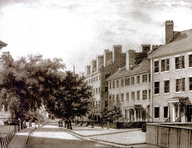
Franklin Street is located in the Financial District of Boston, Massachusetts, United States. It was developed at the end of the 18th century by Charles Bulfinch, and included the now-demolished Tontine Crescent and Franklin Place.

Hawley Street of Boston, Massachusetts, is located in the Financial District between Milk and Summer Streets. Prior to 1799, it was called Bishop's Alley and briefly in the 1790s Board Alley.

Congress Street in Boston, Massachusetts, is located in the Financial District and South Boston. It was first named in 1800. It was extended in 1854 as far as Atlantic Avenue, and in 1874 across Fort Point Channel into South Boston. Today's Congress Street consists of several segments of streets, previously named Atkinson's Street, Dalton Street, Gray's Alley, Leverett's Lane, Quaker Lane, and Shrimpton's Lane.

Merchants Row in Boston, Massachusetts, is a short street extending from State Street to Faneuil Hall Square in the Financial District. Since the 17th century, it has been a place of commercial activity. It sits close to Long Wharf and Dock Square, hubs of shipping and trade through the 19th century. Portions of the street were formerly known as Swing-Bridge Lane, Fish Lane, and Roebuck Passage.

Cornhill was a street in Boston, Massachusetts, in the 18th, 19th and 20th centuries, located on the site of the current City Hall Plaza in Government Center. It was named in 1829; previously it was known as Market Street (1807–1828). In its time, it comprised a busy part of the city near Brattle Street, Court Street and Scollay Square. In the 19th century, it was the home of many bookstores and publishing companies. As of 1969, Cornhill exists as 144 feet along the edge of City Hall Plaza.
Wheeling Island Historic District is a national historic district located on Wheeling Island in Wheeling, Ohio County, West Virginia. The district includes 1,110 contributing buildings, 5 contributing sites, 2 contributing structures, and 3 contributing objects. It is a largely residential district consisting of two-story, frame detached dwellings built in the mid- to late-19th and early-20th century, including the Irwin-Brues House (1853) and a number of houses on Zane Street. The houses are representative of a number of popular architectural styles including Bungalow, Italianate, Queen Anne, and Colonial Revival. Notable non-residential contributing properties include the Exposition Building (1924), Thompson United Methodist Church (1913–1915), Madison School (1916), firehouse (1930–1931), the Bridgeport Bridge (1893), the Aetnaville Bridge (1891), "The Marina," Wheeling Island Baseball Park, and "Belle Island Park." It includes the separately listed Wheeling Suspension Bridge, Harry C. and Jessie F. Franzheim House, and John McLure House.

The Summer Street Bridge is a retractile bridge built in 1899 in Boston, Massachusetts, over the Fort Point Channel. It still stands, but the draw was welded shut and the motors removed in 1970. It was the site of a terrible streetcar crash on the night of November 7, 1916. When documented by the Historic American Engineering Record in 1984, the Summer Street Bridge was one of only four retractile drawbridges left in the US, two of which were on Summer Street in Boston. The other Summer Street bridge, over Reserved Channel, was replaced in 2003.

The Waterworks Museum is a museum in the Chestnut Hill Waterworks building, originally a high-service pumping station of the Boston Metropolitan Waterworks. It contains well-preserved mechanical engineering devices in a Richardsonian Romanesque building.

The Boston Public Garden Foot Bridge is a pedestrian bridge crossing the lagoon in Boston Public Garden, in Boston, Massachusetts, United States. Built in 1867, it was the world's shortest functioning suspension bridge before its conversion to a girder bridge in 1921.