
Route 1A is a north–south state highway in Massachusetts, United States. It is an alternate route to U.S. 1 with three signed sections and two unsigned sections where the highway is concurrent with its parent. Due to the reconfiguration of tunnel interchanges brought on by the completion of the Big Dig, Route 1A is discontinuous in the downtown Boston area. Vehicles entering Downtown Boston via the Sumner Tunnel must take I-93 north to the exit for Government Center and make a U-turn to access the entrance ramp to I-93 south and vice versa.
Fenway–Kenmore is an officially recognized neighborhood of Boston, Massachusetts. While it is considered one neighborhood for administrative purposes, it is composed of numerous distinct sections that, in casual conversation, are almost always referred to as "Fenway", "the Fenway", "Kenmore Square", or "Kenmore". Furthermore, the Fenway neighborhood is divided into two sub-neighborhoods commonly referred to as East Fenway/Symphony and West Fenway.

Washington Street is a street originating in downtown Boston, Massachusetts, which extends southwestward to the Massachusetts–Rhode Island state line. The majority of its length outside of the city was built as the Norfolk and Bristol Turnpike in the early 19th century. It is the longest street in Boston and remains one of the longest streets in the Commonwealth of Massachusetts. Due to various municipal annexations with the city of Boston, the name Washington Street now exists 6 or more times within the jurisdiction(s) of the City of Boston.

New Hampshire Route 47 is a 7.148-mile-long (11.504 km) state highway in southern New Hampshire, United States. It runs from Francestown to Bennington. It is signed as a north–south route, but follows more of an east–west routing. In fact, during its "northernmost" (westernmost) 2.4 miles, it proceeds southwest while signed north.

Orient Heights is a historic section of Boston, Massachusetts, United States, and is commonly considered part of East Boston; it is Boston's northernmost and northeasternmost neighborhood.

Route 2A is a 98.5-mile-long (158.5 km) east–west state highway in Massachusetts. It exists in several sections, mainly as parts of former Route 2 that have been moved or upgraded. Route 2A runs from Greenfield in the west to Boston in the east. It formerly extended to Shelburne Falls in Buckland in the west, but as of 2007, the route terminates at Interstate 91 (I-91) in Greenfield.

Mississippi Highway 4 runs east–west from an intersection in the community of Fox Island west of Tunica, Mississippi, near the border with Arkansas, to MS 25 in Tishomingo County, Mississippi. It travels a distance of 159.8 miles (257.2 km), serving Tunica, Tate, Marshall, Benton, Tippah, Prentiss, and Tishomingo counties.

Central Square is a section of the neighborhood of East Boston in Boston, Massachusetts, United States. The square begins at the intersection of Bennington Street and Meridian Street, continues up Meridian to its intersection with White Street, and includes all the area to the left. The square's intersecting streets also include Border, Saratoga, and Eutaw Street. It is within close proximity of the entrance to the Sumner Tunnel, which motorists take to downtown Boston.
Day Square is a section of the neighborhood of East Boston in Boston, Massachusetts, United States. The square consists of the area surrounding the intersection of Bennington Street and Chelsea Street. It is one of the neighborhood's larger and more active business districts with a number of stores, services, and restaurants.

New York State Route 354 (NY 354) is a state highway in New York in the United States. NY 354 is one of several highways radiating eastward from its western terminus in downtown Buffalo. The east terminus of NY 354 is in the village of Attica, where it ends at NY 98 and NY 238 as West Main Street. This highway runs through the center of Erie County to the northern county line of Wyoming County.

State Route 43 is a mainly north–south state highway that runs through the northeastern quadrant of the U.S. state of Ohio. Its southern terminus is at a signalized intersection with State Route 7 along the Ohio River in Steubenville, and its western terminus is approximately 123 miles (198 km) to the north at Public Square in Cleveland. It is one of ten routes to enter Public Square.

Mississippi Highway 32 is a state highway in northern Mississippi it runs from east to west for 152.0 miles (244.6 km), serving the counties of Bolivar, Sunflower, Tallahatchie, Yalobusha, Calhoun, and Chickasaw. The publicly accessible portion of MS 32 is divided into two sections, the first of which begins near Perthshire and runs eastward to the rear entrance of the Mississippi State Penitentiary (MSP). The second section begins at the main entrance of MSP and runs eastward to MS 32's terminus in Okolona. A private portion of MS 32 runs from the main entrance of MSP to the rear entrance of MSP.

Mississippi Highway 16 is a state highway in central Mississippi. It runs east–west for 186.4 miles (300.0 km), from the Mississippi Delta region to the Alabama state line. MS 16 serves 8 counties: Issaquena, Sharkey, Yazoo, Humphreys, Madison, Leake, Neshoba, and Kemper.

State Route 237 is a primary state highway in the U.S. state of Virginia. The state highway runs 13.07 miles (21.03 km) from SR 236 in Fairfax east to U.S. Route 50 in Arlington. SR 237 connects Fairfax and Arlington with Falls Church. Between Fairfax and Falls Church, the state highway mostly runs concurrently with US 29. East of Falls Church, SR 237 parallels Interstate 66 (I-66) and connects several of Arlington's urban villages.

Boylston Street is a major east–west thoroughfare in the city of Boston, Massachusetts and its western suburbs. The street begins in Boston's Chinatown neighborhood, forms the southern border of the Boston Public Garden and Boston Common, runs through Back Bay and Boston's Fenway neighborhood, merges into Brookline Ave and then Washington Street, emerging again contiguous with Route 9 out to where it crosses Route 128, after which it becomes Worcester Street.

U.S. Route 7 (US 7) is a north–south highway extending from southern Connecticut to the northernmost part of Vermont. In Vermont, the route extends for 176 miles (283 km) along the western side of the state as a mostly two-lane rural road, with the exception of an expressway section between Bennington and East Dorset. US 7 is known as the Ethan Allen Highway for its entire length through the state, named after the US Revolutionary War general. US 7 ends at an interchange with Interstate 89 (I-89) in the town of Highgate, just south of the Canada–United States border. I-89 continues to the border crossing.

U.S. Route 202 is a US Highway running from New Castle, Delaware, northeast to Bangor, Maine. The route runs through the southeastern part of the U.S. state of Pennsylvania, passing through the western and northern suburbs of Philadelphia in the Delaware Valley metropolitan area. US 202 serves largely as a toll-free bypass around the city, avoiding the busy traffic and congestion on Interstate 95 (I-95). It is signed north–south and follows a general southwest–northeast direction through the state, serving West Chester, King of Prussia, Bridgeport, Norristown, Montgomeryville, Doylestown, and New Hope. US 202 enters Pennsylvania from Delaware and heads north as a divided highway, where it becomes concurrent with US 322 at an intersection with US 1 in Painters Crossing. The two routes run north and become a freeway that bypasses West Chester to the east, with US 322 splitting from US 202. US 202 continues north and east along the freeway to King of Prussia, where it reverts to an at-grade divided highway following an interchange with I-76. The route becomes a one-way pair as it passes through Bridgeport and Norristown before both directions rejoin and the road continues northeast. US 202 follows an expressway-grade parkway between Montgomeryville and Doylestown prior to bypassing Doylestown to the south along a freeway. The route continues northeast as an at-grade road to New Hope, where it turns into a freeway again before it crosses the Delaware River on the New Hope–Lambertville Toll Bridge into New Jersey.
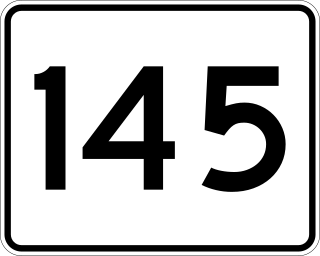
Route 145 is a 6.716-mile-long (10.808 km) circuitous south–north urban state highway in Massachusetts. It is entirely within Suffolk County and primarily serves the peninsular town of Winthrop from East Boston and Revere. Its southern terminus is at Route 1A in East Boston and its northern terminus is at Route 16 in Revere.

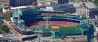
U.S. Route 20 (US 20) runs its easternmost 153 miles (246 km) in the U.S. state of Massachusetts. The highway crosses the state border from New Lebanon, New York, into Hancock and runs eastward to Boston, where it ends at Route 2 in Kenmore Square. It spends the vast majority of its journey paralleling I-90, which has largely superseded US 20 for through travel. Still, US 20 directly serves many towns and local business areas which the turnpike bypasses.
Provincial Trunk Highway 50 is a provincial highway in the south-central region of the Canadian province of Manitoba. It runs from PTH 16 to PTH 5 and PR 361 in the village of McCreary.

