
Route 128, known as the Yankee Division Highway, is an expressway in the U.S. state of Massachusetts maintained by the Highway Division of the Massachusetts Department of Transportation (MassDOT). Spanning 57 miles (92 km), it is one of two beltways around Boston, and is known as the "inner" beltway, especially around areas where it is 15 miles (25 km) or less outside of Boston. The route's current southern terminus is at the junction of I-95 and I-93 in Canton, and it is concurrent with I-95 around Boston for 37.5 miles (60.4 km) before it leaves the interstate and continues on its own in a northeasterly direction towards Cape Ann. The northern terminus lies in Gloucester a few hundred feet from the Atlantic Ocean. All but the northernmost 3 miles are a freeway, with the remainder being an expressway. Its concurrency with I-95 makes up most of its length.

Cohasset is a town in Norfolk County, Massachusetts, United States. As of the 2020 census the population was 8,381.

Hull is a town in Plymouth County, Massachusetts, United States, located on a peninsula at the southern edge of Boston Harbor. Its population was 10,072 at the 2020 census. Hull is the smallest town by land area in Plymouth County and the eleventh smallest in the state. However, its population density is nearly four times that of Massachusetts as a whole.
Hingham is a town in metropolitan Greater Boston on the South Shore of the U.S. state of Massachusetts in northern Plymouth County. At the 2020 census, the population was 24,284. Hingham is known for its colonial history and location on Boston Harbor. The town was named after Hingham, Norfolk, England, and was first settled by English colonists in 1633.

Route 3A is a 97-mile-long (156 km) state highway in eastern Massachusetts, which parallels Route 3 and U.S. Route 3 from Cedarville in southern Plymouth to Tyngsborough at the New Hampshire state line.

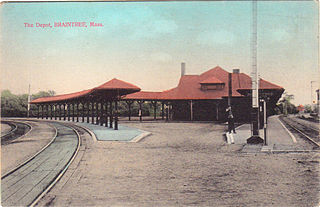
The Greenbush Line is a branch of the MBTA Commuter Rail system which serves the South Shore region of Massachusetts. The 27.6-mile (44.4 km) line runs from downtown Boston, Massachusetts through the cities and towns of Quincy, Braintree, Weymouth, Hingham, Cohasset, and Scituate to the Greenbush neighborhood in southern Scituate. There are ten stations along the line. From South Station, to Quincy Center, service operates in conjunction with the Old Colony Lines commuter rail service via the Old Colony Main Line. From Weymouth Landing/East Braintree to Greenbush, trains utilize the Greenbush Branch, the former South Shore Railroad line that was later incorporated into the Old Colony Railroad.

Nantasket Beach is a beach in the town of Hull, Massachusetts. It is part of the Nantasket Beach Reservation, administered by the state Department of Conservation and Recreation. The shore has fine, light gray sand and is one of the most highly rated beaches in Greater Boston. Due to its gentle slope, at low tide, the beach extends several hundred yards in width, forming tide pools that have become a well known, pictoresque characteristic of the site, renowned for their reflections of the sunsets and sunrises. The northern part of the beach is private, administered by the Town of Hull, and does not allow visitors to park except as guests of residents. The beach is a habitat for federally protected species, including the Piping Plover, Least Tern, and occasionally harbor seals.
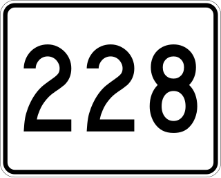
Route 228 is a rather short 9.4-mile-long (15.1 km) south–north highway in southeastern Massachusetts. Its southern terminus is at Route 3 in Rockland and its northern terminus is at George Washington Boulevard in Hull.

Nantasket Junction station is an MBTA Commuter Rail station in Hingham, Massachusetts. It serves the Greenbush Line. It is located off Chief Justice Cushing Highway east of downtown Hingham. It consists of a single side platform serving the line's one track. The station is fully accessible.

Cohasset station is an MBTA Commuter Rail station in Cohasset, Massachusetts. It serves the Greenbush Line. It is located off Chief Justice Cushing Highway west of downtown Cohasset. The station was opened with the line on October 31, 2007, providing the first rail service to Cohasset since 1959. Cohasset station is fully accessible.

The Stony Brook Reservation Parkways are a group of historic parkways in Boston and Dedham, Massachusetts. They provide access to and within the Stony Brook Reservation, a Massachusetts state park. The roadways and the park are administered by the Massachusetts Department of Conservation and Recreation, a successor to the Metropolitan District Commission, which oversaw their construction. The roads consist of the Dedham, Enneking, and Turtle Pond Parkways and West Boundary Road. Two roads within the park, Smithfield Road and Reservation Road, are listed as non-contributing properties. The park roads were built between 1894 and 1956, and were listed on the National Register of Historic Places in 2006.

Fresh Pond Parkway is a historic park and parkway on the western end of Cambridge, Massachusetts. It is part of the Metropolitan Park System of Greater Boston. The parkway was built in 1899 and added to the National Register of Historic Places in 2005.
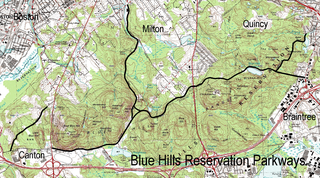
The Blue Hills Reservation Parkways are a network of historic parkways in and around the Blue Hills Reservation, a Massachusetts state park south of Boston, Massachusetts. It consists of six roadways that provide circulation within the park, and that join the park to two connecting parkways, the Blue Hills Parkway and the Furnace Brook Parkway. The roadway network was designed by Charles Eliot in the 1890s, except for Green Street, which was added to the network in the 1940s. The parkways were added to the National Register of Historic Places in 2003.

The Fells Connector Parkways are a group of historic parkways in the cities of Malden and Medford, Massachusetts, suburbs north of the city of Boston. The three parkways, The Fellsway, Fellsway West, and Fellsway East serve to provide access from the lower portion of the Mystic River Reservation to the Middlesex Fells Reservation. The latter two parkways continue northward, providing access to the interior of the Fells and providing a further connection to Lynn Fells Parkway. Significant portions of these parkways south of the Fells, which were among the first connecting parkways designed to be part of the Metropolitan Park System of Greater Boston by Charles Eliot, were listed on the National Register of Historic Places in 2003.

The Middlesex Fells Reservation Parkways are the roadways within and bordering on the Middlesex Fells Reservation, a state park in the northern suburbs of Boston, Massachusetts, United States. The park includes portions of the towns of Malden, Medford, Melrose, Stoneham, and Winchester. The roads inside the park and around its perimeter have been listed on the National Register of Historic Places. Other portions of some of the roads are covered by more than one listing in the national register; see Fellsway Connector Parkways and Middlesex Fells Reservoirs Historic District.
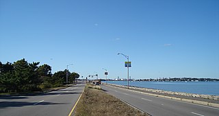
Quincy Shore Drive is a historic parkway in Quincy, Massachusetts. The road is one of a series of parkways built by predecessors of the Massachusetts Department of Conservation and Recreation, to provide access to parks and beaches in the Greater Boston area. Its development was proposed in 1893 by Charles Eliot, who promoted the development of many of the area's parks and parkways. Planning began in 1897, with land acquisition following around 1900. Construction of the 4-mile (6.4 km) road was begun in 1903 and completed in 1907.

Blue Hills Parkway is a historic parkway that runs in a straight line from a crossing of the Neponset River, at the south border of Boston to the north edge of the Blue Hills Reservation in Milton, Massachusetts. It was built in 1893 to a design by the noted landscape architect, Charles Eliot, who is perhaps best known for the esplanades along the Charles River. The parkway is a connecting road between the Blue Hills Reservation and the Neponset River Reservation, and was listed on the National Register of Historic Places in 2003.

Hingham Bay is the easternmost of the three small bays of outer Boston Harbor, part of Massachusetts Bay and forming the western shoreline of the town of Hull and the northern shoreline of Hingham in the United States state of Massachusetts. It lies east of Quincy Bay and is met at the southwest by the mouth of Weymouth Fore River, also forming part of the waterfront of Weymouth. The bay is home to several of the Boston Harbor Islands.

Weir River is a short stream and estuary that empties into Hingham Bay, part of Boston Harbor in Massachusetts, United States. The name is attributed to the location of a fishing weir in the stream. The river gives its name to a larger watershed and Weir River Farm, a park and nature reserve owned by The Trustees of Reservations.
The South Shore Railroad was a railroad in Massachusetts. It was incorporated in 1846 to provide rail service between Quincy and Duxbury, Massachusetts through the towns of Hingham, Cohasset, Scituate and Marshfield.


