
Hull is a town in Plymouth County, Massachusetts, United States, located on a peninsula at the southern edge of Boston Harbor. Its population was 10,072 at the 2020 census. Hull is the smallest town by land area in Plymouth County and the fourth smallest in the state. However, its population density is nearly four times that of Massachusetts as a whole.
The Boston Harbor Islands National Recreation Area is a national recreation area situated among the islands of Boston Harbor of Boston, Massachusetts. The area is made up of a collection of islands, together with a former island and a peninsula, many of which are open for public recreation and some of which are very small and best suited for wildlife. The area is run by the Boston Harbor Islands Partnership. It includes the Boston Harbor Islands State Park, managed by the Commonwealth of Massachusetts. Twenty-one of the 34 islands in the area are also included in the Boston Harbor Islands Archeological District.

Castle Island is a peninsula in South Boston on the shore of Boston Harbor. In 1928, Castle Island was connected to the mainland by a narrow strip of land and is thus no longer an island. It has been the site of a fortification since 1634, and is currently a 22-acre (8.9 ha) recreation site and the location of Fort Independence.
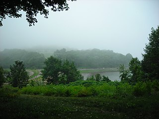
World's End is a 251-acre (1 km²) park and conservation area located on a peninsula in Hingham, Massachusetts. The peninsula is bordered by the Weir River to the North and East and Hingham Harbor to the West. The land is composed of four drumlins harboring tree groves interspersed with fields attractive to butterflies and grassland-nesting birds, and offers 4.5 miles of walking paths with views of the Boston skyline.

The Department of Conservation and Recreation (DCR) is a state agency of the Commonwealth of Massachusetts, situated in the Executive Office of Energy and Environmental Affairs. It is best known for its parks and parkways. The DCR's mission is "To protect, promote and enhance our common wealth of natural, cultural and recreational resources for the well-being of all." The agency is the largest landowner in Massachusetts.

Middlesex Fells Reservation, often referred to simply as the Fells, is a public recreation area covering more than 2,200 acres (890 ha) in Malden, Medford, Melrose, Stoneham, and Winchester, Massachusetts. The state park surrounds two inactive reservoirs, Spot Pond and the Fells Reservoir, and the three active reservoirs that are part of the water supply system for the town of Winchester. Spot Pond and the Fells Reservoir are part of the Wachusett water system, one of six primary water systems that feed metropolitan Boston's waterworks. The park is managed by the Massachusetts Department of Conservation and Recreation and is part of the Metropolitan Park System of Greater Boston.

Wompatuck State Park is a state-owned, public recreation area of about 3,500 acres (1,400 ha) in size located primarily in the town of Hingham with portions in the neighboring towns of Cohasset, Norwell, and Scituate, Massachusetts, in the United States. In addition to a large campground and an extensive trail system, the park is noted for the free spring water that can be obtained at Mt. Blue Spring, which has been in operation since the mid-19th century. The park is managed by the Massachusetts Department of Conservation and Recreation which protects forests of the northeastern coastal forests ecoregion.

Pilgrim Memorial State Park comprises two monuments — Plymouth Rock and the National Monument to the Forefathers — in Plymouth, Massachusetts. Closely related to these memorials is the Myles Standish Monument State Reservation which can be seen across the Plymouth Bay in Duxbury, Massachusetts. Owned by the Commonwealth of Massachusetts, these sites are managed by the Massachusetts Department of Conservation and Recreation.
Chicopee Memorial State Park is a public recreation area covering 562 acres (227 ha) in the Burnett Road neighborhood of the city of Chicopee, Massachusetts. The state park is located directly southeast of Westover Air Reserve Base, which is visible from some parts of the park. It is managed by the Department of Conservation and Recreation.
Dorchester Shores Reservation is a Massachusetts state park consisting of three non-contiguous areas totaling 44 acres (18 ha) along the eastern edge of the Dorchester section of Boston. The area is composed of beaches and a park along the extended mouth of the Neponset River: Savin Hill/Malibu Beach, Tenean Beach, and Victory Road Park. Savin Hill is adjacent to Malibu Beach and has been restored to its original Olmsted Brothers design. The reservation is managed by the Department of Conservation and Recreation.

Spinnaker Island is an island in the Hingham Bay area of Boston Harbor in Massachusetts, USA. The island is part of the town of Hull, to which it is connected by a bridge, and is one of the few harbor islands that neither forms part of the Boston Harbor Islands National Recreation Area nor is considered within the municipal limits of the city of Boston.

Wollaston Beach is the largest public beach in the Boston harbor. The beach is located parallel to Quincy Shore Drive in North Quincy, Massachusetts, which was constructed to provide access to the bay beach for Greater Boston. Wollaston beach expands Quincy Bay forming part of Boston Harbor. The northern end of the beach is the Native American historical site, Moswetuset Hummock which is where the original Moswetuset Sac'hem (Chief) had a tribal council.

Squantum Point Park is a state-owned, public recreation area located on the Squantum peninsula of Quincy, Massachusetts, United States. The park was created on the site of the former Squantum Naval Air Station, which is preserved in a 2,700-foot-long (820 m) strip of runway, and the former dockworks of the Bethlehem Shipbuilding Corporation. The park is managed by the Massachusetts Department of Conservation and Recreation and is associated with the development of the Neponset River Reservation.
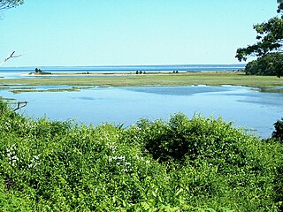
Ellisville Harbor State Park is a nature preserve and public recreation area located in the village of Ellisville, Massachusetts, United States, on the western shore of Cape Cod Bay. Natural features of the coastal property include a barrier beach, sphagnum bog, salt marsh, rolling meadows, and red pine forest habitats. Scenic features include views of the South Shore coastline, small fishing boats, harbor seals seen offshore during fall and winter, and birds attracted to the park's bog as both habitat and migration stopover. The state park is managed by the Department of Conservation and Recreation.

Tolland State Forest is a publicly owned forest with recreational features covering 4,415 acres (1,787 ha) in the towns of Otis, Tolland, Blandford and Sandisfield in the southern Berkshire Hills of Massachusetts. The state forest centers on the 1,065-acre (431 ha) Otis Reservoir, the largest body of water for recreational use in western Massachusetts. The forest is managed by the Department of Conservation and Recreation.

The Metropolitan Park System of Greater Boston is a system of reservations, parks, parkways and roads under the control of the Massachusetts Department of Conservation and Recreation (DCR) in and around Boston that has been in existence for over a century. The title is used by the DCR to describe the areas collectively: "As a whole, the Metropolitan Park System is currently eligible for listing on the National Register of Historic Places", as outlined on the department's website. The DCR maintains a separate Urban Parks and Recreation division to oversee the system, one of five such divisions within the department—DCR's Bureau of State Parks and Recreation manages the remainder of Massachusetts state parks. Direct design and maintenance functions for the parkways and roads within the system are provided by the DCR Bureau of Engineering.

Quincy Shore Reservation is a public recreation area and protected shoreline on Quincy Bay, Boston Harbor, in Quincy, Massachusetts. Its primary attraction is a 2.3-mile-long (3.7 km) beach, accessible along its entire length by Quincy Shore Drive. The largest beach on Boston Harbor, it is known locally as Wollaston Beach, named for the adjacent Wollaston neighborhood.

Weymouth Back River Reservation is a protected coastal reservation in Hingham and Weymouth, Massachusetts. It contains parks on the west and east sides of the northern end of Weymouth Back River. On the west side in Weymouth, Abigail Adams Park is adjacent to and north of Route 3A Bridge and Great Esker Park is south of the bridge. On the east side in Hingham, Stodder's Neck is north of the bridge and Bare Cove Park is south of the bridge. It features Weymouth Back River views, walking trails and landscaped areas.

Hingham Bay is the easternmost of the three small bays of outer Boston Harbor, part of Massachusetts Bay and forming the western shoreline of the town of Hull and the northern shoreline of Hingham in the United States state of Massachusetts. It lies east of Quincy Bay and is met at the southwest by the mouth of Weymouth Fore River, also forming part of the waterfront of Weymouth. The bay is home to several of the Boston Harbor Islands.


