
The Mass Central Rail Trail is a partially-completed rail trail from Northampton, Massachusetts to Boston along the former right of way of the Massachusetts Central Railroad. When complete, it will run 104 miles (167 km) through Central Massachusetts and Greater Boston. Many segments of the trail, including the Norwottuck Branch Rail Trail and the Somerville Community Path, have been developed as separate projects but will serve as part of the complete Mass Central Rail Trail.
Massachusetts's 2nd congressional district is located in central Massachusetts. It contains the cities of Worcester, which is the second-largest city in New England after Boston, and Northampton in the Pioneer Valley. It is represented by Democrat Jim McGovern.
Big Six Mile Creek Marina is a 21-acre (0.085 km2) state park and marina located on the upper Niagara River on Grand Island in Erie County, New York.

Seneca Creek is a 5.8-mile-long (9.3 km) stream in Montgomery County, Maryland, USA, roughly 16 miles (26 km) northwest of Washington, D.C. It drains into the Potomac River.
Wompatuck State Park is a state-owned, public recreation area of about 3,500 acres (1,400 ha) in size located primarily in the town of Hingham with portions in the neighboring towns of Cohasset, Norwell, and Scituate, Massachusetts, in the United States. In addition to a large campground and an extensive trail system, the park is noted for the free spring water that can be obtained at Mt. Blue Spring, which has been in operation since the mid-19th century. The park is managed by the Massachusetts Department of Conservation and Recreation which protects forests of the northeastern coastal forests ecoregion.

Dunn State Park is a public recreation area surrounding a 20-acre (8.1 ha) pond in Gardner, Massachusetts. The state park covers 132 acres (53 ha) and is managed by the Department of Conservation and Recreation.

Hopkinton State Park is a Massachusetts state park located in the towns of Hopkinton and Ashland and managed by the Department of Conservation and Recreation. The park was created after the Hopkinton Reservoir was removed from service as a water source for the Greater Boston area. In 2010, it was named as one of the 1,000 places to visit by the Great Places in Massachusetts Commission.
The Quinebaug River is a river in south-central Massachusetts and eastern Connecticut, with watershed extending into western Rhode Island. The name "Quinebaug" comes from the southern New England Native American term, spelled variously Qunnubbâgge, Quinibauge, etc., meaning "long pond", from qunni-, "long", and -paug, "pond". The river is one of the namesake rivers in the Quinebaug and Shetucket Rivers Valley National Heritage Corridor.
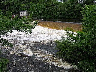
The East Brimfield Dam is located on the Quinebaug River in Sturbridge, Massachusetts, approximately 20 miles (32 km) southwest of Worcester, Massachusetts.

Mount Sugarloaf State Reservation is a state-owned, public recreation area managed by the Massachusetts Department of Conservation and Recreation located in South Deerfield, just west of the Connecticut River. The state park includes the summits of North Sugarloaf Mountain and South Sugarloaf Mountain, as well as 1.75 miles of frontage on the Connecticut River and two river islands. The park is part of a larger park designation called the Connecticut River Greenway State Park. Portions of the park property along the river are used by the University of Massachusetts Amherst for agricultural research.
The Blackstone River and Canal Heritage State Park is a part of the state park system of the Commonwealth of Massachusetts, managed by the Massachusetts Department of Conservation and Recreation (DCR). This 1,000-acre (4.0 km2) park "recalls the role of canals in transporting raw materials and manufactured goods between emerging industrial centers." The Blackstone River and Canal Heritage State Park at Uxbridge, Massachusetts, is the midpoint of the Blackstone River Valley National Heritage Corridor of the National Park System. The Blackstone River and Valley is where the industrial revolution was born in America. The southern entrance to this state park is the site of the historic Stanley Woolen Mill, currently being redeveloped for commercial and tourism. The Native American Nipmuc name for the village here was "Wacentug", translated as "bend in the river".
The Mount Tom Range is a traprock mountain range located in the Connecticut River Valley of Massachusetts. It is part of the Metacomet Ridge that extends from Long Island Sound near New Haven, Connecticut, north through the Connecticut River Valley of Massachusetts to nearly the Vermont border. A popular outdoor recreation resource, the range is known for its continuous west facing cliffs and its rugged, scenic character. It is also notable for its unique microclimate ecosystems and rare plant communities, as well as significant historic sites, such as the ruins of the 18th century Eyrie House located on Mount Nonotuck.
Commonwealth Connections is a greenway and conservation initiative co-developed by the Commonwealth of Massachusetts Department of Conservation and Recreation (DCR), the National Park Service, and over fifty trail and land conservation agencies and non-profit organizations. Begun in 1999, the initiative was designed to create "a coordinated greenway and trail network that will help conserve important resources, provide recreation and alternative transportation opportunities close to where people live, and connect communities throughout Massachusetts."

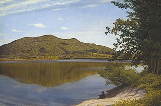
The Oxbow, also known as the Ox-Bow, is an extension of the Connecticut River, located in Northampton, Massachusetts. It is well-known for its appearance in the 1836 painting The Oxbow by Thomas Cole.

Muddy Branch is a tributary stream of the Potomac River in Montgomery County, Maryland, United States, located about 14 miles (23 km) northwest of Washington, D.C.
The Connecticut River Railroad was a railroad located along the Connecticut River in western Massachusetts, formed in 1845 from the merger of two unfinished railroads. Its main line from Springfield to East Northfield, Massachusetts, opened in stages between 1845 and 1849. It built several branches and over the years acquired additional lines in Vermont. The railroad was acquired by the Boston and Maine Railroad in 1893.

Pope John Paul II Park Reservation, also known as Pope Park, is a 66-acre (27 ha) Massachusetts state park bordering the Neponset River in the Dorchester section of Boston. The park has been reclaimed from the former site of a landfill and the Neponset Drive-In as part of the Lower Neponset River Master Plan and the development of the Neponset River Reservation. The park is managed by the Department of Conservation and Recreation (DCR).

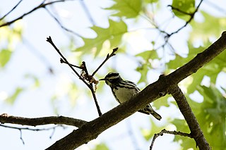
Farm River State Park is a privately operated, publicly owned recreation area on the western shore of the Farm River estuary in the town of East Haven, Connecticut. Public access to the 62-acre state park is limited and boating is restricted to those with passes obtained from Quinnipiac University, which manages the park for the Connecticut Department of Energy and Environmental Protection. Park activities include nature trail hiking, bird watching, and fishing.

