The term is recent, dating to the 1990s, and sometimes confused with the South Shore (a region southeast of Boston that includes eastern Norfolk and Plymouth counties, and does not overlap with the South Coast).
Terminology
The "South Coast" label was born as a public relations effort to counteract the perceived stigma of former terms like "Greater Fall River," "Greater New Bedford," or "New Bedford-Fall River," which conjured images, in many Massachusetts residents' minds, of depressed mill towns with run-down buildings and high unemployment. Local boosters, including The Standard-Times newspaper, began using the term in the mid-1990s in an effort to attract business to an area with "the Cape's climate," "better infrastructure" and "relatively low land prices," according to Standard-Times publisher William Kennedy.[1]
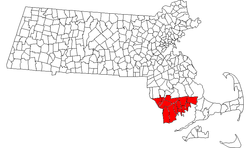
Geography
Communities
There are 15 Massachusetts municipalities that are almost always included in the South Coast (total population: 306,588). Two Rhode Island towns may also be included.[2]
The South Coast region is typically associated with its distinct industrial heritage pertaining to textile, whaling, and fishing industries; the South Coast also has the largest Portuguese American population in the United States.[6][7]
Farm Coast
In recent years, an unofficial sub-region of the South Coast known as the Farm Coast has been used to describe the cluster of rural towns that are situated on the northern coast of Buzzards Bay; these towns are considered to be the last coastal farming communities left in Southern New England and share a common regional identity and aesthetic. The Farm Coast consists of the towns of Tiverton, Little Compton, Westport and Dartmouth.[8][9][10]
Education
UMass Dartmouth is known for its brutalist campus structures
Institutions of higher learning located in South Coast communities include:
The term "South Coast" reportedly began with weather forecasts by Todd Gross on WHDH-TV in Boston. New Bedford's local daily newspaper, The Standard-Times, picked it up in the late 1990s, and other media have followed suit, albeit not without some protest by longtime area residents who protested the manufactured name.[1]
Radio stations include ethnic WHTB/1400-Fall River, news/talk/sports WBSM/1420-New Bedford, news/talk/sports WSAR/1480-Fall River, religious ethnic WFHL/88.1-New Bedford, K-LoveWTKL/91.1-North Dartmouth, Portuguese-language WJFD-FM/97.3-New Bedford, country WCTK/98.1-New Bedford, top 40/dance WFHN/107.1-Fairhaven, and public radio news WNPN/89.3-Newport, RI.
Television stations include ABC affiliate WLNE-TV/49 (PSIP 6)-New Bedford and CW affiliate WLWC/22 (PSIP 28)-New Bedford.
↑"Ambrose F. Keeley Library the Information Center of B.M.C. Durfee High School: History of Fall River, Massachusetts and Rhode Island Boundary question" (PDF). www.sailsinc.org.
This page is based on this Wikipedia article Text is available under the CC BY-SA 4.0 license; additional terms may apply. Images, videos and audio are available under their respective licenses.