South Shore (Massachusetts)

Last updated
South Shore
Irish Riviera
South Shore MA.png
The South Shore region of Massachusetts
Coordinates: 42°00′N70°45′W / 42°N 70.75°W / 42; -70.75 Coordinates: 42°00′N70°45′W / 42°N 70.75°W / 42; -70.75
Country United States
State Massachusetts
Cities and towns Braintree, Cohasset, Duxbury, Hingham, Hull, Kingston, Marshfield, Plymouth, Quincy, Rockland, Scituate and Weymouth, sometimes adding inland towns
Area
  Total632.9 sq mi (1,639 km2)
Population
 (2010)
  Total541,364
  Density860/sq mi (330/km2)
Largest city (population) Quincy (92,271)
Largest city (land) Plymouth (134 square miles)

The South Shore of Massachusetts is a geographic region stretching south and east from Boston toward Cape Cod along the shores of Massachusetts Bay and Cape Cod Bay. It is subject to varying descriptions including municipalities in eastern Norfolk and Plymouth counties. The South Shore is an affluent area. The median income of the region as of 2020 is $104,691. The median home value of the region as of 2020 is $574,831.

Contents

Depending on its geographical definition, the South Shore is composed of a mix of suburban towns, mid-sized industrial cities and rural towns. Massachusetts' heaviest concentration of Irish-American residents and descendants from ancestors from Ireland is on the South Shore, [1] and 6 of the United States' 10 most Irish towns are located on the South Shore, which is sometimes referred to locally as the Irish Riviera . [2] [3]

Geography

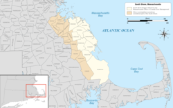
By its most literal definition, the South Shore includes only cities and towns between Boston and Cape Cod that physically border the Atlantic Ocean, thereby limiting the South Shore to the following:

The Massachusetts Office of Coastal Zone Management limits its definition of the South Shore to the municipalities between Boston Harbor and Cape Cod, which includes Atlantic coastal and coastal watershed areas "from the three-mile (5 km) limit of the state territorial sea to 100 feet (30 m) beyond the first major land transportation route encountered (a road, highway, rail line, etc.)". [4] This definition eliminates Braintree, Quincy and Weymouth, which border Boston Harbor, but adds the towns of Hanover, Norwell and Pembroke. [5]

With respect to regional planning and cooperation among municipal governments, some of these coastal communities are either members of the Boston-centered Inner Core Committee of the Metropolitan Area Planning Council (MAPC) [6] or not part of the metropolitan area at all, while the South Shore Coalition of the MAPC comprises representatives from 13 coastal and inland communities [7] and includes the following cities and towns:

The South Shore Chamber of Commerce includes all of the above towns, as well as several more farther inland in Norfolk and Plymouth counties, in its definition of the region: [8]

Informal definitions of South Shore—defined by the service areas of other nonprofits or businesses with "South Shore" in their names, by real estate agents, or by individuals, for example—always include at least some of the shoreline communities but can stretch considerably to the west. Readers of Boston magazine, in 2016, identified "Anything below the city, Cape included" as one potential definition of "South Shore". Suggested western boundaries included the Rhode Island state line, or Massachusetts Route 24. Some individuals placed Foxborough and Stoughton in the region. One definition included all of Cape Cod, as far as Provincetown; others said the South Shore ends at the Sagamore Bridge, which would place part of Bourne in the region. [9]

Education

Institutions of higher learning located in South Shore communities include:

Sites of interest

See also

Footnotes

  1. Schworm, Peter. "Digging Their Celtic Roots." The Boston Globe, June 19, 2005
  2. "Massachusetts rules list of Irish towns". ePodunk. Retrieved 12 January 2011.
  3. Sweeney, Emily. "How the South Shore became the Irish Riviera". The Boston Globe. Retrieved 12 January 2011.
  4. "The Coastal Zone". Massachusetts Office of Coastal Zone Management. Retrieved 2009-09-05.
  5. "CZM's Regional Offices". Massachusetts Office of Coastal Zone Management. Retrieved 2009-09-05.
  6. "MAPC - Inner Core Committee:". Metropolitan Area Planning Council. Archived from the original on May 9, 2009. Retrieved 2009-05-17.
  7. "MAPC - South Shore Coalition". Metropolitan Area Planning Council. Archived from the original on September 27, 2007. Retrieved 2009-05-17.
  8. "Our Region", South Shore Chamber of Commerce. Accessed May 30, 2020.
  9. "Interactive Map: North Shore vs. South Shore", Boston, March 27, 2016. Accessed May 30, 2020.

Related Research Articles

<span class="mw-page-title-main">Cape Cod</span> Cape in the northeastern United States

Cape Cod is a peninsula extending into the Atlantic Ocean from the southeastern corner of mainland Massachusetts, in the northeastern United States. Its historic, maritime character and ample beaches attract heavy tourism during the summer months. The name Cape Cod, coined in 1602 by Bartholomew Gosnold, is the ninth oldest English place-name in the U.S.

<span class="mw-page-title-main">Wellfleet, Massachusetts</span> Town in Massachusetts, United States

Wellfleet is a town in Barnstable County, Massachusetts, United States, and is located halfway between the "tip" and "elbow" of Cape Cod. The town had a population of 3,566 at the 2020 census, which swells nearly sixfold during the summer. A total of 70% of the town's land area is under protection, and nearly half of it is part of the Cape Cod National Seashore. Wellfleet is famous for its oysters, which are celebrated in the annual October Wellfleet OysterFest.

<span class="mw-page-title-main">Plymouth County, Massachusetts</span> County in Massachusetts, United States

Plymouth County is a county in the U.S. state of Massachusetts, south of Boston. As of the 2020 census, the population was 530,819. Its county seats are Plymouth and Brockton. In 1685, the county was created by the Plymouth General Court, the legislature of Plymouth Colony, predating its annexation by the Massachusetts Bay Colony.

<span class="mw-page-title-main">Norwell, Massachusetts</span> Town in Massachusetts, United States

Norwell is a town in Plymouth County, Massachusetts, United States. The population was 11,351 at the 2020 United States census. The town's southeastern border runs along the North River.

<span class="mw-page-title-main">Pembroke, Massachusetts</span> Town in Massachusetts, United States

Pembroke is an historic town in Plymouth County, Massachusetts, United States. Pembroke is a South Shore suburb of the Boston metropolitan area. The town is located about halfway between Boston and Cape Cod. The town is considered rural with pockets of suburban neighborhoods. The median household income was $119,827 at the 2020 census. The population was 18,361 at the 2020 census.

<span class="mw-page-title-main">Marshfield, Massachusetts</span> Town in Massachusetts, United States

Marshfield is a town in Plymouth County, Massachusetts, United States, on Massachusetts's South Shore. The population was 25,825 at the 2020 census.

<span class="mw-page-title-main">Plymouth, Massachusetts</span> Town in Massachusetts, United States

Plymouth is a town in Plymouth County, Massachusetts, United States. Located in Greater Boston, the town holds a place of great prominence in American history, folklore, and culture, and is known as "America's Hometown". Plymouth was the site of the colony founded in 1620 by the Mayflower Pilgrims, where New England was first established. It is the oldest municipality in New England and one of the oldest in the United States. The town has served as the location of several prominent events, one of the more notable being the First Thanksgiving feast. Plymouth served as the capital of Plymouth Colony from its founding in 1620 until the colony's merger with the Massachusetts Bay Colony in 1691. The English explorer John Smith named the area Plymouth and the region 'New England' during his voyage of 1614. It was a later coincidence that, after an aborted attempt to make the 1620 trans-Atlantic crossing from Southampton, the Mayflower finally set sail for America from Plymouth, England.

<span class="mw-page-title-main">Scituate, Massachusetts</span> Town in Massachusetts, United States

Scituate is a seacoast town in Plymouth County, Massachusetts, United States, on the South Shore, midway between Boston and Plymouth. The population was 19,063 at the 2020 census.

<span class="mw-page-title-main">North Shore (Massachusetts)</span> Region of Massachusetts in the United States

The North Shore is a region in the U.S. state of Massachusetts, loosely defined as the coastal area between Boston and New Hampshire. The region is made up both of a rocky coastline, dotted with marshes and wetlands, as well as several beaches and natural harbors. The North Shore is an important historical, cultural, and economic region of Massachusetts. The southern part of the region includes Boston's densely populated inner northeast suburbs, including Salem. At the center of the North Shore lies its most prominent geographic feature, Cape Ann, with numerous small fishing towns, and at the northern end lies the Merrimack Valley, which was a major locus of the Industrial Revolution in the United States.

<span class="mw-page-title-main">Greater Boston</span> Metropolitan area in the United States

Greater Boston is the metropolitan region of New England encompassing the municipality of Boston and its surrounding areas. The region forms the northern arc of the Northeast megalopolis, so Greater Boston means both a metropolitan statistical area (MSA) and a combined statistical area (CSA), which is broader. The MSA consists of most of the eastern third of Massachusetts, excluding the South Coast and Cape Cod; the CSA additionally includes the municipalities of Providence, Manchester, Worcester, the South Coast region, and Cape Cod. While the city of Boston covers 48.4 square miles (125 km2) and has 675,647 residents as of the 2020 census, the urbanization has extended well into surrounding areas and the CSA has a population of more than 8.4 million people, making it one of the most populous such regions in the U.S. The CSA is one of two in Massachusetts, the other being Greater Springfield. Greater Boston is the only CSA in New England that lies in three states ; some definitions extend it into a fourth (Connecticut),and a fifth (Maine).

Irish Riviera is a slang expression that can refer to any of several seaside communities in the United States with high population densities of Irish-Americans, including:

<span class="mw-page-title-main">Geography of Massachusetts</span> Overview of the geography of Massachusetts

Massachusetts is the 7th smallest state in the United States with an area of 10,555 square miles (27,340 km2). It is bordered to the north by New Hampshire and Vermont, to the west by New York, to the south by Connecticut and Rhode Island, and to the east by the Atlantic Ocean and Gulf of Maine. Massachusetts is the most populous New England state.

<span class="mw-page-title-main">Massachusetts Route 3A</span> State highway in eastern Massachusetts, US

Route 3A is a 97-mile-long (156 km) state highway in eastern Massachusetts, which parallels Route 3 and U.S. Route 3 from Cedarville in southern Plymouth to Tyngsborough at the New Hampshire state line.

<span class="mw-page-title-main">Massachusetts's 16th congressional district</span>

Massachusetts's sixteenth congressional district is an obsolete district. It was also for a short time in the early 19th century a Massachusetts District of Maine. It was eliminated in 1933 after the 1930 Census. Its last location was in eastern Massachusetts at Cape Cod. Its last Congressman was Charles L. Gifford, who was redistricted into the fifteenth district.

<span class="mw-page-title-main">Southeastern Massachusetts</span> Region of Massachusetts in the United States

Southeastern Massachusetts consists of those portions of Massachusetts located along Buzzards Bay, including the cities of New Bedford and Fall River and their respective suburbs. Despite the location of Cape Cod and the islands to its south, which are the southeasternmost parts of the state, they are not always grouped in this designation. At its broadest definition, it includes all of Massachusetts south of Boston, southeast of Worcester, and east of Providence, Rhode Island, while at its narrowest definition, it is Bristol County and the Western portion of Plymouth County.

Humarock is part of Scituate, Massachusetts, United States. Humarock is a picturesque seaside village surrounded by water and situated on Cape Cod Bay midway between Boston and Plymouth. It was separated from the rest of the town in the Portland Gale of 1898 in which the mouth of the North River shifted. Humarock is now accessible from Scituate only by boat or from the Town of Marshfield by bridge.

The Old Colony Library Network (OCLN) is a consortium of 28 member libraries located on the South Shore of Massachusetts in the United States. OCLN membership includes 26 town and city libraries and two academic libraries. OCLN's cooperative approach enables member libraries to provide services that they would not be able to afford separately. OCLN was founded in 1984 and is incorporated in Massachusetts as a 501(c)3 corporation. OCLN is recognized as a charitable organization by the Massachusetts Attorney General's office.

Mariner Group, based in Marshfield, Massachusetts, United States, was a chain of weekly newspapers in the suburban South Shore near Boston, Massachusetts, United States. Founded in 1972 with one paper, the Marshfield Mariner, the group was sold in 1989 to Capital Cities/ABC and again in 1995 to Fidelity Investments, which dissolved it into Community Newspaper Company a few months later.

<span class="mw-page-title-main">Middleborough/Lakeville station</span> Commuter rail station in Lakeville, Massachusetts

Middleborough/Lakeville station is an MBTA Commuter Rail station in Lakeville, Massachusetts, just south of the Middleborough border. It is the southern terminus of the Middleborough/Lakeville Line; it is also an intermediate stop for seasonal CapeFlyer service to Cape Cod. Middleborough/Lakeville has a single full-length high-level side platform serving the line's single track.

<span class="mw-page-title-main">Middleborough station</span> Rail station in Middleborough, Massachusetts, US

Middleborough station is an under-construction MBTA Commuter Rail station in Middleborough, Massachusetts. It is expected to open in late 2023 as part of the South Coast Rail project, replacing Middleborough/Lakeville station for regular service. The station will have a single side platform located inside the wye between the Middleborough Main Line and the Middleboro Secondary.