Derry, New Hampshire

Last updated

Derry, New Hampshire
DerryNH AdamsMemorialBuilding 03.jpg
The Adams Memorial Building, home of the Derry Opera House
DerrySeal.jpg
Nickname: 
"Spacetown"
Rockingham County New Hampshire incorporated and unincorporated areas Derry highlighted.svg
Coordinates: 42°52′50″N71°19′38″W / 42.88056°N 71.32722°W / 42.88056; -71.32722
CountryUnited States
State New Hampshire
County Rockingham
Incorporated 1827
Villages
Government
   Town Council
Members
  • Erin Spencer
  • Charles Foote
  • Jim MacEachern
  • Brian Chirichiello
  • Jack Webb
  • David Granese
  • Douglas Flood
  Town AdministratorDavid Caron
Area
[1]
  Total36.3 sq mi (94.0 km2)
  Land35.5 sq mi (91.9 km2)
  Water0.8 sq mi (2.1 km2)  2.26%
Elevation
282 ft (86 m)
Population
 (2020) [2]
  Total34,317
  Density967/sq mi (373.5/km2)
Time zone UTC-5 (Eastern)
  Summer (DST) UTC-4 (Eastern)
ZIP code
03038
Area code 603
FIPS code 33-17940
GNIS feature ID0873578
Website www.derrynh.org

Derry is a town in Rockingham County, New Hampshire, United States. The population was 34,317 at the 2020 census. [2] Although it is a town and not a city, Derry is the most populous community in Rockingham County and the 4th most populous in the state. The town's nickname, "Spacetown", derives from the fact that Derry is the birthplace of Alan Shepard, the first astronaut from the United States in space. [3] Derry was also for a time the home of the poet Robert Frost and his family.

Contents

The Derry census-designated place, with a 2020 population of 22,879, occupies the central part of the town, extending from Derry's downtown in the west to the town of Hampstead in the east. The town also includes the village of East Derry.

History

The area was first settled by Scots-Irish families in 1719 as part of the town of Londonderry, as were present-day Windham and portions of Manchester, Salem and Hudson. The town of Derry was formed in 1827 from the eastern portion of Londonderry and was named, like Londonderry, after the city of Derry in Ireland, [4] the Irish word Doire meaning "oak grove". The first potato planted in the United States was sown in Derry in the town's common field in 1719. [5] The town is the location of two of America's oldest private schools, Pinkerton Academy, founded in 1814 and still in operation, and the closed Adams Female Seminary.

Derry was once a linen [6] and leather-making center until New England textile industries moved south in the 20th century. As recently as World War II, Derry was also a sleepy farming community. From 1900 to 1911, poet Robert Frost lived with his family on a farm in Derry purchased for him by his grandfather. The Robert Frost Farm is now a National Historic Landmark and state park and is open to the public for tours, poetry readings and other cultural events from spring through fall. [7]

The post-war suburban boom, the town's proximity to Boston in the south and Manchester to the northwest, and the construction of Interstate 93 through town led to a huge population boom. After the 1990s, this growth disappeared, with the population remaining essentially unchanged since 2000.

The Manchester and Lawrence branch of the Boston and Maine Railroad ran through Derry, but is now abandoned, with most of the line in town now a rail trail. The New Hampshire Department of Transportation stated in its I-93 corridor transit study [8] and its 2012 statewide rail plan [9] that it could be feasible to reopen the line.

Historical postcards

Geography

Derry is in southern New Hampshire, in southwestern Rockingham County. It is 12 miles (19 km) southeast of Manchester, the state's largest city, and 16 miles (26 km) northwest of Lawrence, Massachusetts. The town is crossed by Interstate 93 and New Hampshire routes 28, 28 Bypass, and 102.

According to the United States Census Bureau, the town has a total area of 36.3 square miles (94.0 km2), of which 35.5 square miles (91.9 km2) are land and 0.81 square miles (2.1 km2) are water, comprising 2.26% of the town. [1] Derry is drained by Beaver Brook, a southward-flowing tributary of the Merrimack River. Island Pond is on the southeastern border of the town and drains to the Spicket River, another tributary of the Merrimack. A small section along the northern border of town drains north to the Exeter River, part of the Piscataqua River watershed. [10] The highest point in the town is Warner Hill, at 605 feet (184 m) above sea level, where from the top one can see the Boston skyline on a clear day.

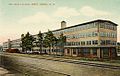
Derry's downtown is located near the town's western border at the intersection of Routes 102 and 28, and the village of East Derry is located approximately 2 miles (3 km) to the east and close to the geographic center of the town. Both areas are part of the Derry census-designated place.

Adjacent municipalities

Climate

Derry has a four-season humid continental climate (Köppen Dfa), with long, cold, snowy winters, and very warm and somewhat humid summers; spring and fall in between are crisp and relatively brief transitions. Precipitation is well-spread throughout the year, including snowfall in the winter.

Demographics

Historical population
CensusPop.Note
1830 2,178
1840 2,034−6.6%
1850 1,850−9.0%
1860 1,9957.8%
1870 1,809−9.3%
1880 2,14018.3%
1890 2,60421.7%
1900 3,58337.6%
1910 5,12343.0%
1920 5,3825.1%
1930 5,131−4.7%
1940 5,4005.2%
1950 5,8267.9%
1960 6,98719.9%
1970 11,71267.6%
1980 18,87561.2%
1990 29,60356.8%
2000 34,02114.9%
2010 33,109−2.7%
2020 34,3173.6%
U.S. Decennial Census [2] [11]

As of the 2020 census, [12] there were 34,317 people residing in the town. The racial makeup of the town was 88.1% White, 2.3% African American, 1.8% American Indian and Alaska Native, 2.3% Asian, 0.1% Pacific Islander, 0.9% some other race, and 1.7% from two or more races. 4.6% of the population were Hispanic or Latino of any race.

As of the census of 2010, there were 12,537 households, out of which 35.0% had children under the age of 18 living with them, 52.4% had a married couple living together, 12.2% had a woman whose husband does not live with her, and 30.1% were non-families. 23.0% of all households were made up of individuals, and 6.4% had someone living alone who was 65 years of age or older. The average household size was 2.62, and the average family size was 3.10.

In the town, the population was spread out, with 24.7% under the age of 18, 9.3% from 18 to 24, 27.0% from 25 to 44, 30.4% from 45 to 64, and 8.7% who were 65 years of age or older. The median age was 38.2 years. For every 100 females, there were 98.6 males. For every 100 females age 18 and over, there were 95.9 males.

At the 2000 census the median income for a household in the town was $54,634, and the median income for a family was $61,625. Males had a median income of $41,271 versus $30,108 for females. The per capita income for the town was $22,315. 4.6% of the population and 3.3% of families were below the poverty line. Out of the total people living in poverty, 5.0% were under the age of 18 and 7.1% were 65 or older.

Government

Derry town vote
by party in presidential elections [13]
Year Democratic Republican Third Parties
2020 45.91% 8,21552.60%9,4121.49% 267
2016 40.35% 6,82554.62%9,2375.03% 851
2012 46.87% 7,61251.42%8,3501.71% 277
2008 47.86% 7,52750.51%7,9441.63% 257
2004 45.33% 6,76053.90%8,0380.77% 114
2000 45.57% 5,53050.21%6,0934.22% 512
1996 45.55%4,81442.61% 4,50311.85% 1,252
1992 32.57% 3,96239.04%4,75028.39% 3,454
1988 30.72% 2,84567.52%6,2531.76% 163
1984 26.24% 1,97273.19%5,5010.57% 43
1980 23.53% 1,51962.89%4,06013.58% 877
1976 40.91% 2,27256.61%3,1442.48% 138
1972 30.17% 1,52667.69%3,4242.14% 108
1968 35.03% 1,47656.74%2,3918.23% 347
1964 53.09%1,88246.91% 1,6630.00% 0
1960 39.24% 1,31360.76%2,0330.00% 0

In the New Hampshire Senate, Derry is in the 19th district and is currently represented by Republican Regina Birdsell. On the Executive Council of New Hampshire, Derry is in district 3 and is currently represented by Republican Janet Stevens. In the U.S. House of Representatives, Derry is included in New Hampshire's 1st congressional district and is currently represented by Democrat Chris Pappas.

Derry is part of a reliably Republican belt of dense, populous towns along Interstate 93 near the Massachusetts border. Derry leans Republican in presidential elections, and has even trended rightwards as of late. Bill Clinton did manage to carry the town with a plurality of the vote in 1996. No Democrat has won a majority of Derry’s voters since Lyndon B. Johnson's landslide election in 1964.

Economy

Top employers

According to the town's 2020 Comprehensive Annual Financial Report, the top employers in the town are the following: [14]

#Employer# of employees
1Derry Cooperative School District620
2 HCA Health Services of New Hampshire (Parkland Medical Center)532
3 Pinkerton Academy 462
4Town of Derry364
5 Walmart 265
6 Hannaford 142
7 Shaw's 105
8 Fireye 100
9Benson's Hardware50
10Total Air Supply40

Transportation

Five New Hampshire state highways and one Interstate Highway cross the town of Derry:

The nearest air transport is Manchester–Boston Regional Airport. There is currently no passenger rail service in Derry, though a former train depot in the center of town has been converted to a hub for the main commercial district in town. Amtrak provides Downeaster service and the MBTA' Haverhill Line at Haverhill station, 32 miles to the southeast.

Education

Pinkerton Academy Pinkertontower.JPG
Pinkerton Academy

Public schools

Private schools

Media

Derry is home to two media sources, the weekly Derry News, which is owned by The Eagle-Tribune and television station WWJE-DT, owned by Univision Communications. Derry is located within the Boston television market and the Manchester radio market. Derry Community Television, also known as DerryCAM, is the town's public-access television station on local cable TV.

The weekly Nutfield News, which was locally owned by Nutfield Publishing, was published until December 2022. [15]

Notable people

Tsienneto Boat Club c. 1910 Ishieneto Boat Club, Derry, NH.jpg
Tsienneto Boat Club c.1910

Sites of interest

Sister cities

Related Research Articles

<span class="mw-page-title-main">Rockingham County, New Hampshire</span> County in New Hampshire, United States

Rockingham County is a county in the U.S. state of New Hampshire. As of the 2020 census, the population was 314,176, making it New Hampshire's second-most populous county. The county seat is Brentwood. Rockingham County is part of the Boston-Cambridge-Newton, MA-NH Metropolitan Statistical Area and the greater Boston-Worcester-Providence, MA-RI-NH-CT Combined Statistical Area. Per the 2020 census, it was New Hampshire's fastest growing county from 2010 to 2020.

<span class="mw-page-title-main">Pelham, New Hampshire</span> Town in New Hampshire, United States

Pelham is a town in Hillsborough County, New Hampshire, United States. The population was 14,222 at the 2020 census, up from 12,897 at the 2010 census.

<span class="mw-page-title-main">Atkinson, New Hampshire</span> Place in New Hampshire, United States

Atkinson is a town in Rockingham County, New Hampshire, United States. The population was 7,087 at the 2020 census.

<span class="mw-page-title-main">Auburn, New Hampshire</span> Place in New Hampshire, United States

Auburn is a town in Rockingham County, New Hampshire, United States. The population was 5,946 at the 2020 census, up from 4,953 at the 2010 census.

<span class="mw-page-title-main">Candia, New Hampshire</span> Place in New Hampshire, United States

Candia is a town in Rockingham County, New Hampshire, United States. The population was 4,013 at the 2020 census. The town includes the villages of Candia, Candia Four Corners and East Candia.

<span class="mw-page-title-main">Hampstead, New Hampshire</span> Place in New Hampshire, United States

Hampstead is a town in Rockingham County, New Hampshire, United States. The population was 8,998 at the 2020 census. Hampstead, which includes the village of East Hampstead, is home to a portion of the Rockingham Recreational Trail.

<span class="mw-page-title-main">Plaistow, New Hampshire</span> Place in New Hampshire, United States

Plaistow is a town in Rockingham County, New Hampshire, United States. The population was 7,830 at the 2020 census.

<span class="mw-page-title-main">Salem, New Hampshire</span> Town in New Hampshire, United States

Salem is a town in Rockingham County, New Hampshire, United States. The population was 30,089 at the 2020 census and an estimated 30,647 in 2022. Salem is a northern suburb of Boston located on Interstate 93. As the first town along I-93 northbound in New Hampshire, which lacks any state sales tax, Salem has grown into a regional commercial hub for many nearby Massachusetts towns, anchored by the Mall at Rockingham Park and Tuscan Village. Other major sites include Canobie Lake Park, a large amusement park; and America's Stonehenge, a stone structure of disputed origins. It is the former home of Rockingham Park, a horse racetrack. The Sununu political family hails from Salem, including former New Hampshire governor and White House Chief of Staff John H. Sununu, and his sons John E. Sununu, a former U.S. senator, and Chris Sununu, current New Hampshire governor.

<span class="mw-page-title-main">Sandown, New Hampshire</span> Town in New Hampshire, United States

Sandown is a town in Rockingham County, New Hampshire, United States. The population was 6,548 at the 2020 census, up from 5,986 at the 2010 census.

<span class="mw-page-title-main">Windham, New Hampshire</span> Town in New Hampshire, United States

Windham is a suburban town in Rockingham County, New Hampshire, United States. The population at the 2020 census was 15,817, up from 13,592 in 2010.

<span class="mw-page-title-main">Hooksett, New Hampshire</span> Town in New Hampshire, United States

Hooksett is a town in Merrimack County, New Hampshire, United States. The population was 14,871 at the 2020 census, up from 13,451 at the 2010 census. The town is located between Manchester, the state's largest city, and Concord, the state capital. A prominent landmark is Robie's Country Store, a National Historic Landmark and a frequent stop for presidential candidates during the New Hampshire primary.

<span class="mw-page-title-main">Derry (CDP), New Hampshire</span> Census-designated place in New Hampshire, United States

Derry is a census-designated place (CDP) in the town of Derry in Rockingham County, New Hampshire, United States. The CDP comprises the urban center of the town, as well as the village of East Derry and connected suburban areas. The population of the CDP was 22,879 at the 2020 census, out of 34,317 in the entire town.

<span class="mw-page-title-main">Londonderry (CDP), New Hampshire</span> Census-designated place in New Hampshire, United States

Londonderry is a census-designated place (CDP) within the town of Londonderry in Rockingham County, New Hampshire, United States. The population of the CDP was 11,645 at the 2020 census, out of 25,826 in the entire town.

<span class="mw-page-title-main">Londonderry, New Hampshire</span> Town in Rockingham County, New Hampshire, United States of America

Londonderry is a town in western Rockingham County, New Hampshire, United States. It sits between Manchester and Derry, the largest and fourth-largest communities in the state. The population was 25,826 at the 2020 census. Londonderry is known for its apple orchards and is home to the headquarters of Stonyfield Farm and part of Manchester–Boston Regional Airport.

<span class="mw-page-title-main">Hudson, New Hampshire</span> Town in New Hampshire, United States

Hudson is a town in Hillsborough County, New Hampshire, United States. It is located along the Massachusetts state line. The population was 25,394 at the 2020 census. It is the tenth-largest municipality in the state, by population.

<span class="mw-page-title-main">New Hampshire Route 28</span> State highway in eastern New Hampshire, US

New Hampshire Route 28 is an 85.413-mile-long (137.459 km) north–south state highway in eastern New Hampshire. It connects the town of Ossipee in east-central New Hampshire with Salem on the Massachusetts border, while passing through Manchester, the largest city in the state.

<span class="mw-page-title-main">New Hampshire Route 102</span> State highway in southern New Hampshire, US

New Hampshire Route 102 is a 23.956-mile-long (38.553 km) state highway in Rockingham and Hillsborough counties in the southern part of the U.S. state of New Hampshire. NH 102 runs southwest to northeast between Hudson and Raymond, but is signed as an east–west route.

<span class="mw-page-title-main">New Hampshire Route 121</span> State highway in southeastern New Hampshire, US

New Hampshire Route 121 is a 22.555-mile-long (36.299 km) north–south state highway in Rockingham and Hillsborough counties in southeastern New Hampshire. The road winds through the communities of Atkinson, Hampstead, Sandown, Derry, Chester, and Auburn. The southern terminus of NH 121 is at the Massachusetts state line in Plaistow, where the road, named Atkinson Depot Road, continues into the city of Haverhill as an unnumbered local road leading to Route 125. The northern terminus is at a traffic circle, where NH 121 meets New Hampshire Route 28 Bypass in eastern Manchester. At this point, the road is known as Manchester Road.

<span class="mw-page-title-main">David McGregore</span>

David McGregore, also known as McGregor, MacGregore or MacGregor, was a Presbyterian Minister and Member of the Colonial America Christian Clergy. He brought his family and congregation of Scotch-Irish immigrants to America on five ships in 1718 and settled in a part of New Hampshire called Nutfield, which covers the modern towns of Derry, Londonderry, and Windham. Rev. David McGregor's sermons were very much ahead of his time and sheds light on the religious sentiments of colonial New England. He questioned the old scriptures and seems to have believed in experimenting in new beliefs and new forms of religion, which was considered very revolutionary for his time.

<span class="mw-page-title-main">Merrimack Valley</span> Region in the U.S. states of New Hampshire and Massachusetts

The Merrimack Valley is a bi-state region along the Merrimack River in the U.S. states of New Hampshire and Massachusetts. The Merrimack is one of the larger waterways in New England and has helped to define the livelihood and culture of those living along it for millennia.

References

  1. 1 2 "2021 U.S. Gazetteer Files – New Hampshire". United States Census Bureau. Retrieved December 21, 2021.
  2. 1 2 3 "Derry town, Rockingham County, New Hampshire: 2020 DEC Redistricting Data (PL 94-171)". U.S. Census Bureau. Retrieved December 21, 2021.
  3. "Derry, NH". NewHampshire.com. Archived from the original on August 30, 2010. Retrieved January 27, 2011.
  4. Gannett, Henry (1905). The Origin of Certain Place Names in the United States. Govt. Print. Off. p. 104.
  5. Brown, Janice (October 18, 2014). "New Hampshire: First in the Nation Potato". Cow Hampshire Blog. Retrieved September 5, 2019.
  6. Belknap, Jeremy (1813). The History of New Hampshire, volume II. Boston: Bradford and Read. p. 32.
  7. "Frost, Robert, Homestead". National Park Service - National Historic Landmarks Program. Archived from the original on June 6, 2011. Retrieved January 27, 2011.
  8. HNTB Corporation (November 2009). "I-93 Corridor Multi-Modal Transit Investment Study" (PDF). New Hampshire Department of Transportation. Retrieved September 28, 2015.
  9. "New Hampshire State Rail Plan" (PDF). New Hampshire Department of Transportation. 2012. Retrieved September 28, 2015.
  10. Foster, Debra H.; Batorfalvy, Tatianna N.; Medalie, Laura (1995). Water Use in New Hampshire: An Activities Guide for Teachers. U.S. Department of the Interior and U.S. Geological Survey.
  11. "Census of Population and Housing". Census.gov. Retrieved June 4, 2016.
  12. "Profile of General Population and Housing Characteristics: 2010 Demographic Profile Data, Derry town, New Hampshire". United States Census Bureau . Retrieved September 20, 2011.
  13. "Election Results". sos.nh.gov.
  14. "Town of Derry, New Hampshire: Comprehensive Annual Financial Report for the Fiscal Year Ending June 30, 2020" (PDF). 2020. p. 137.
  15. Paul, Debra. "Nutfield News and Tri-Town Times Will No Longer Be Published". Nutfield News. Nutfield News. Archived from the original on January 1, 2023. Retrieved January 8, 2023.
  16. "Samantha Brown". New Hampshire.com. Retrieved March 12, 2014.
  17. "Younger Lions: Caleb Chapman". Jazzed. September 20, 2011. Retrieved March 12, 2014.
  18. Reid, John Phillip (1967). Chief Justice: The Judicial World of Charles Doe. Harvard University Press. p. 28. ISBN   978-0674114005.
  19. "Tricia Dunn-Luoma". Sports Reference LLC. Archived from the original on April 17, 2020. Retrieved March 12, 2014.
  20. Marquis, Albert Nelson (1915). Who's who in New England: A Biographical Dictionary of Leading Living Men and Women of the States of Maine, New Hampshire, Vermont, Massachusetts, Rhode Island and Connecticut. A.N. Marquis. p. 415.
  21. "Robert Frost Farm State Historic Site". Parks & Recreation New Hampshire. Archived from the original on March 13, 2014. Retrieved March 12, 2014.
  22. "Patterson, William (1789 - 1838)". Biographical Directory of the United States Congress. Retrieved March 12, 2014.
  23. Adams Memorial Opera House
  24. Derry Historical Society & Museum
  25. Taylor Mill State Historic Site, a reconstructed water-powered sawmill
  26. Rockingham Recreational Trail
  27. "Derry councilors accept gift from 'sister' city".

Further reading