Epping (CDP), New Hampshire

Last updated

Epping, New Hampshire
Main Street, Epping NH.jpg
Main Street
USA New Hampshire location map.svg
Red pog.svg
Epping
Usa edcp location map.svg
Red pog.svg
Epping
Coordinates: 43°2′21″N71°4′23″W / 43.03917°N 71.07306°W / 43.03917; -71.07306
Country United States
State New Hampshire
County Rockingham
Town Epping
Area
[1]
  Total4.34 sq mi (11.23 km2)
  Land4.30 sq mi (11.14 km2)
  Water0.04 sq mi (0.09 km2)
Elevation
129 ft (39 m)
Population
 (2020)
  Total2,693
  Density626.13/sq mi (241.77/km2)
Time zone UTC-5 (Eastern (EST))
  Summer (DST) UTC-4 (EDT)
ZIP code
03042
Area code 603
FIPS code 33-24580
GNIS feature ID2378062

Epping is a census-designated place (CDP) and the main village in the town of Epping, Rockingham County, New Hampshire, United States. The population of the CDP was 2,693 at the 2020 census, [2] out of 7,125 in the entire town.

Contents

Geography

The CDP is in the south-central part of the town of Epping, comprising most of the main village of Epping, part of the village of West Epping, and less densely developed land in between. The CDP is bordered to the south by the New Hampshire Route 101 expressway and to the west by the Lamprey River from NH 101 to NH 27 (Pleasant Street). The northern border of the CDP follows NH 27 and the Lamprey River, until the village of Epping in the eastern part of the CDP, where it follows Prescott Road and Old Hedding Road to Delaney Road, east of NH 125. The eastern border stays east of NH 125 from Old Hedding Road to NH 101. [3]

NH Route 101, with one exit in Epping, leads east 12 miles (19 km) to Interstate 95 in Hampton and west 19 miles (31 km) to Interstate 93 in Manchester. Route 125, which intersects Route 101 at Exit 7 in Epping, leads north 21 miles (34 km) to Rochester and south 20 miles (32 km) to Haverhill, Massachusetts. Route 27, the pre-expressway routing of Route 101, leads east 7 miles (11 km) to Exeter and west 6 miles (10 km) to Raymond.

According to the U.S. Census Bureau, the Epping CDP has a total area of 4.3 square miles (11.2 km2), of which 0.04 square miles (0.1 km2), or 0.82%, are water. [4] The Lamprey River passes through Epping village, flowing east toward Great Bay.

Demographics

Historical population
CensusPop.Note
1970 1,097
1980 1,38426.2%
1990 1,3840.0%
2000 1,67320.9%
2010 1,6810.5%
2020 2,69360.2%
U.S. Decennial Census [5]

As of the census of 2010, there were 1,681 people, 766 households, and 447 families residing in the CDP. There were 847 housing units, of which 81, or 9.6%, were vacant. The racial makeup of the CDP was 96.7% white, 0.3% African American, 0.1% Native American, 1.0% Asian, 0.0% Pacific Islander, 1.1% some other race, and 1.8% from two or more races. 1.2% of the population were Hispanic or Latino of any race. [6]

Of the 766 households in the CDP, 24.3% had children under the age of 18 living with them, 43.5% were headed by married couples living together, 10.2% had a female householder with no husband present, and 41.6% were non-families. 33.7% of all households were made up of individuals, and 13.2% were someone living alone who was 65 years of age or older. The average household size was 2.19, and the average family size was 2.79. [6]

18.2% of residents in the CDP were under the age of 18, 9.8% were from age 18 to 24, 24.3% were from 25 to 44, 29.7% were from 45 to 64, and 18.1% were 65 years of age or older. The median age was 43.4 years. For every 100 females, there were 87.8 males. For every 100 females age 18 and over, there were 83.1 males. [6]

For the period 2011-15, the estimated median annual income for a household was $50,438, and the median income for a family was $57,083. Male full-time workers had a median income of $50,917 versus $48,447 for females. The per capita income for the CDP was $27,359. 9.5% of the population and 4.5% of families were below the poverty line. [7]

Related Research Articles

<span class="mw-page-title-main">Newfields, New Hampshire</span> Place in New Hampshire, United States

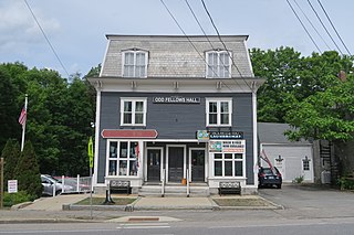
Newfields is a town in Rockingham County, New Hampshire, United States. The population was 1,769 at the 2020 census. The primary village in town, where 378 people resided at the 2020 census, is defined as the Newfields census-designated place (CDP) and is located along New Hampshire Route 85 and the Squamscott River. It is a quaint village of handsome old houses.

<span class="mw-page-title-main">Wolfeboro (CDP), New Hampshire</span> Census-designated place in New Hampshire, United States

Wolfeboro is a census-designated place (CDP) in the town of Wolfeboro in Carroll County, New Hampshire, United States. It consists of the main village of Wolfeboro within the town, as well as the smaller village of Wolfeboro Falls. The population of the CDP was 3,300 at the 2020 census, out of 6,416 in the entire town of Wolfeboro.

<span class="mw-page-title-main">Marlborough (CDP), New Hampshire</span> Census-designated place in New Hampshire, United States

Marlborough is a census-designated place (CDP) and the main village in the town of Marlborough in Cheshire County, New Hampshire, United States. The population of the CDP was 1,066 at the 2020 census, out of 2,096 in the entire town.

<span class="mw-page-title-main">Bristol (CDP), New Hampshire</span> Census-designated place in New Hampshire, United States

Bristol is a census-designated place (CDP) and the main village in the town of Bristol in Grafton County, New Hampshire, United States. The population of the CDP was 1,911 at the 2020 census, out of 3,244 in the entire town.

<span class="mw-page-title-main">Peterborough (CDP), New Hampshire</span> Census-designated place in New Hampshire, United States

Peterborough is a census-designated place (CDP) and the main village in the town of Peterborough, Hillsborough County, New Hampshire, United States. The population of the CDP was 3,090 at the 2020 census, out of 6,418 in the entire town.

<span class="mw-page-title-main">Wilton (CDP), New Hampshire</span> Census-designated place in New Hampshire, United States

Wilton is a census-designated place (CDP) and the main village in the town of Wilton, Hillsborough County, New Hampshire, United States. The CDP extends east into the town of Milford as well. The population of the CDP was 1,324 at the 2020 census, up from 1,163 at the 2010 census.

<span class="mw-page-title-main">Derry (CDP), New Hampshire</span> Census-designated place in New Hampshire, United States

Derry is a census-designated place (CDP) in the town of Derry in Rockingham County, New Hampshire, United States. The CDP comprises the urban center of the town, as well as the village of East Derry and connected suburban areas. The population of the CDP was 22,879 at the 2020 census, out of 34,317 in the entire town.

<span class="mw-page-title-main">Epping, New Hampshire</span> Place in New Hampshire, United States

Epping is a town in Rockingham County, New Hampshire, United States. The population was 7,125 at the 2020 census, up from 6,411 at the 2010 census.

<span class="mw-page-title-main">Exeter (CDP), New Hampshire</span> Census-designated place in New Hampshire, United States

Exeter is a census-designated place (CDP) and the main village in the town of Exeter, Rockingham County, New Hampshire, United States. The population of the CDP was 10,109 at the 2020 census, out of 16,049 in the entire town.

<span class="mw-page-title-main">Hampton (CDP), New Hampshire</span> Census-designated place in New Hampshire, United States

Hampton is a census-designated place (CDP) comprising the town center and surrounding developed areas of the town of Hampton, Rockingham County, New Hampshire, United States. The population of the CDP was 9,597 at the 2020 census, out of 16,214 in the entire town.

<span class="mw-page-title-main">Newmarket (CDP), New Hampshire</span> Census-designated place in New Hampshire, United States

Newmarket is a census-designated place (CDP) and the main village in the town of Newmarket in Rockingham County, New Hampshire, United States. The population of the CDP was 5,797 at the 2020 census, out of 9,430 in the entire town.

<span class="mw-page-title-main">Raymond (CDP), New Hampshire</span> Census-designated place in New Hampshire, United States

Raymond is a census-designated place (CDP) and the main village in the town of Raymond, Rockingham County, New Hampshire, United States. The population of the CDP was 3,738 at the 2020 census, out of 10,684 in the entire town.

<span class="mw-page-title-main">Newport (CDP), New Hampshire</span> Census-designated place in New Hampshire, United States

Newport is a census-designated place (CDP) comprising the main village and surrounding rural land in the town of Newport, Sullivan County, New Hampshire, United States. The population of the CDP was 4,735 at the 2020 census, out of 6,299 in the entire town.

<span class="mw-page-title-main">North Woodstock, New Hampshire</span> Census-designated place in New Hampshire, United States

North Woodstock is a census-designated place (CDP) and the primary village in the town of Woodstock in Grafton County, New Hampshire, United States. It had a population of 739 at the 2020 census.

<span class="mw-page-title-main">Newfields (CDP), New Hampshire</span> Census-designated place in New Hampshire, United States

Newfields is a census-designated place (CDP) and the main village within the town of Newfields, Rockingham County, New Hampshire, United States. The population of the CDP was 378 at the 2020 census, out of 1,769 in the entire town.

New Hampton is a census-designated place (CDP) and the main village in the town of New Hampton in Belknap County, New Hampshire, United States. The population was 373 at the 2020 census, out of 2,377 people in the entire town of New Hampton.

<span class="mw-page-title-main">Ashland (CDP), New Hampshire</span> Census-designated place in New Hampshire, United States

Ashland is a census-designated place (CDP) and the main village in the town of Ashland in Grafton County, New Hampshire, United States. The population of the CDP was 1,082 at the 2020 census, out of 1,938 in the entire town.

<span class="mw-page-title-main">Bennington (CDP), New Hampshire</span> Census-designated place in New Hampshire, United States

Bennington is a census-designated place (CDP) and the main village in the town of Bennington in Hillsborough County, New Hampshire, United States. The population of the CDP was 338 at the 2020 census, out of 1,501 in the entire town.

Bethlehem is a census-designated place (CDP) and the main village in the town of Bethlehem in Grafton County, New Hampshire, United States. The population of the CDP was 826 at the 2020 census, out of 2,484 in the entire town.

<span class="mw-page-title-main">Colebrook (CDP), New Hampshire</span> Census-designated place in New Hampshire, United States

Colebrook is a census-designated place (CDP) and the main village in the town of Colebrook, Coös County, New Hampshire, United States. The population of the CDP was 1,201 at the 2020 census, out of 2,084 in the entire town. The CDP population had dropped from 1,394 at the 2010 census.

References

  1. "ArcGIS REST Services Directory". United States Census Bureau. Retrieved September 20, 2022.
  2. "Epping CDP, New Hampshire: 2020 DEC Redistricting Data (PL 94-171)". U.S. Census Bureau. Retrieved January 3, 2022.
  3. "TIGERweb: Epping CDP, New Hampshire". Geography Division, U.S. Census Bureau. Retrieved January 26, 2021.
  4. "2021 U.S. Gazetteer Files – New Hampshire". United States Census Bureau. Retrieved January 3, 2022.
  5. "Decennial Census Official Publications". Census.gov. Retrieved March 4, 2024.
  6. 1 2 3 "Profile of General Population and Housing Characteristics: 2010 Census Summary File 1 (DP-1): Epping CDP, New Hampshire". U.S. Census Bureau, American Factfinder. Archived from the original on February 13, 2020. Retrieved October 2, 2017.
  7. "Selected Economic Characteristics: 2011-2015 American Community Survey 5-Year Estimates (DP03): Epping CDP, New Hampshire". U.S. Census Bureau, American Factfinder. Archived from the original on February 13, 2020. Retrieved October 2, 2017.