Exeter (CDP), New Hampshire

Last updated

Exeter, New Hampshire
Bandstand, Exeter NH.jpg
Exeter Bandstand
USA New Hampshire location map.svg
Red pog.svg
Exeter
Usa edcp location map.svg
Red pog.svg
Exeter
Coordinates: 42°58′53″N70°56′51″W / 42.98139°N 70.94750°W / 42.98139; -70.94750
Country United States
State New Hampshire
County Rockingham
Town Exeter
Area
[1]
  Total4.65 sq mi (12.03 km2)
  Land4.50 sq mi (11.65 km2)
  Water0.15 sq mi (0.39 km2)
Elevation
20 ft (6 m)
Population
 (2020)
  Total10,109
  Density2,248.44/sq mi (868.08/km2)
Time zone UTC-5 (Eastern (EST))
  Summer (DST) UTC-4 (EDT)
ZIP code
03833
Area code 603
FIPS code 33-25300
GNIS feature ID2378063

Exeter is a census-designated place (CDP) and the main village in the town of Exeter, Rockingham County, New Hampshire, United States. The population of the CDP was 10,109 at the 2020 census, [2] out of 16,049 in the entire town.

Contents

Geography

The CDP is in the southeastern part of the town of Exeter, on both sides of the Exeter River where it flows into the tidal Squamscott River. The CDP is bordered to the northeast by the town of Stratham and to the east by New Hampshire Route 101, Dearborn Brook, and New Hampshire Route 88 (Holland Way and Hampton Falls Road). The southern edge of the CDP is formed by an unnamed brook and the Exeter River. The western border of the CDP follows the Pan Am Railways line and the Little River to Colcord Pond. The northern border follows Allard Street and Epping Road (New Hampshire Route 27), passes through woodlands to Oak Street Extension, then follows Forest Street, Wadleigh Street, Salem Street, the Pan Am Railways line again, and Norris Brook to the Squamscott River, which it follows north to the Stratham town line. [3]

NH Route 101 bypasses the CDP to the north, with access from three exits. Route 101 leads east 4 miles (6 km) to Interstate 95 in Hampton and west 26 miles (42 km) to Interstate 93 in Manchester. New Hampshire Route 108 passes through the center of the CDP, leading north 12 miles (19 km) to Durham and south 18 miles (29 km) to Haverhill, Massachusetts. New Hampshire Route 27 passes through the center of Exeter as Main Street, Water Street, and High Street, and leads east and west parallel to Route 101. New Hampshire Route 111 runs west out of town as Front Street, leading 7 miles (11 km) to Kingston, and heads east out of town with Route 27 before splitting east-northeast to North Hampton. New Hampshire Route 88 leads southeast from the east side of Exeter 5 miles (8 km) to Hampton Falls. Route 85 leads north from the center of the CDP 4 miles (6 km) to Newfields. New Hampshire Route 111A leads west from Exeter 7 miles (11 km) to Brentwood.

According to the U.S. Census Bureau, the Exeter CDP has a total area of 4.6 square miles (12.0 km2), of which 4.5 square miles (11.6 km2) are land and 0.2 square miles (0.4 km2), or 3.24%, are water. [4] The Squamscott River, which starts in the CDP at the head of tide where the Exeter River flows into it, runs north from Exeter to Great Bay.

Demographics

Historical population
CensusPop.Note
1950 4,977
1960 5,89618.5%
1970 6,4399.2%
1980 8,94739.0%
1990 9,5566.8%
2000 9,7592.1%
2010 9,242−5.3%
2020 10,1099.4%
U.S. Decennial Census [5]

As of the census of 2010, there were 9,242 people, 4,077 households, and 2,368 families residing in the CDP. There were 4,342 housing units, of which 265, or 6.1%, were vacant. The racial makeup of the CDP was 95.3% white, 0.6% African American, 0.1% Native American, 2.0% Asian, 0.02% Pacific Islander, 0.2% some other race, and 1.8% from two or more races. 1.6% of the population were Hispanic or Latino of any race. [6]

Of the 4,077 households in the CDP, 28.3% had children under the age of 18 living with them, 42.4% were headed by married couples living together, 11.6% had a female householder with no husband present, and 41.9% were non-families. 34.5% of all households were made up of individuals, and 13.5% were someone living alone who was 65 years of age or older. The average household size was 2.23, and the average family size was 2.88. [6]

22.1% of residents in the CDP were under the age of 18, 6.7% were from age 18 to 24, 24.2% were from 25 to 44, 31.8% were from 45 to 64, and 15.4% were 65 years of age or older. The median age was 43.2 years. For every 100 females, there were 90.2 males. For every 100 females age 18 and over, there were 86.7 males. [6]

For the period 2011-15, the estimated median annual income for a household was $66,495, and the median income for a family was $86,373. Male full-time workers had a median income of $55,853 versus $43,114 for females. The per capita income for the CDP was $38,703. 8.0% of the population and 4.5% of families were below the poverty line, along with 7.4% of people under the age of 18 and 4.6% of people 65 or older. [7]

Related Research Articles

<span class="mw-page-title-main">Newfields, New Hampshire</span> Place in New Hampshire, United States

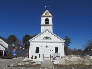
Newfields is a town in Rockingham County, New Hampshire, United States. The population was 1,769 at the 2020 census. The primary village in town, where 378 people resided at the 2020 census, is defined as the Newfields census-designated place (CDP) and is located along New Hampshire Route 85 and the Squamscott River. It is a quaint village of handsome old houses.

<span class="mw-page-title-main">North Hampton, New Hampshire</span> Place in New Hampshire, United States

North Hampton is a town in Rockingham County, New Hampshire, United States. The population was 4,538 at the 2020 census. While the majority of the town is inland, North Hampton includes a part of New Hampshire's limited Atlantic seacoast.

<span class="mw-page-title-main">Stratham, New Hampshire</span> Town in New Hampshire, United States

Stratham is a town in Rockingham County, New Hampshire, United States. The town had a population of 7,669 at the 2020 census. It is bounded on the west by the Squamscott River. The town is the home of the only U.S. Lindt & Sprüngli factory and the headquarters of the Timberland Corporation.

<span class="mw-page-title-main">Exeter, New Hampshire</span> Town in New Hampshire, United States

Exeter is a town in Rockingham County, New Hampshire, United States. Its population was 16,049 at the 2020 census, up from 14,306 at the 2010 census. Exeter was the county seat until 1997, when county offices were moved to neighboring Brentwood. Home to Phillips Exeter Academy, a private university-preparatory school, Exeter is situated where the Exeter River becomes the tidal Squamscott River.

<span class="mw-page-title-main">Marlborough (CDP), New Hampshire</span> Census-designated place in New Hampshire, United States

Marlborough is a census-designated place (CDP) and the main village in the town of Marlborough in Cheshire County, New Hampshire, United States. The population of the CDP was 1,066 at the 2020 census, out of 2,096 in the entire town.

Lancaster is a census-designated place (CDP) and the main village in the town of Lancaster in Coos County, New Hampshire, United States. The population of the CDP was 1,941 at the 2020 census, out of 3,218 in the entire town of Lancaster.

<span class="mw-page-title-main">Bristol (CDP), New Hampshire</span> Census-designated place in New Hampshire, United States

Bristol is a census-designated place (CDP) and the main village in the town of Bristol in Grafton County, New Hampshire, United States. The population of the CDP was 1,911 at the 2020 census, out of 3,244 in the entire town.

<span class="mw-page-title-main">Greenville (CDP), New Hampshire</span> Census-designated place in New Hampshire, United States

Greenville is a census-designated place (CDP) and the main village in the town of Greenville in Hillsborough County, New Hampshire, United States. The population of the CDP was 1,074 at the 2020 census, out of 1,974 in the entire town.

<span class="mw-page-title-main">Epping (CDP), New Hampshire</span> Census-designated place in New Hampshire, United States

Epping is a census-designated place (CDP) and the main village in the town of Epping, Rockingham County, New Hampshire, United States. The population of the CDP was 2,693 at the 2020 census, out of 7,125 in the entire town.

<span class="mw-page-title-main">Hampton (CDP), New Hampshire</span> Census-designated place in New Hampshire, United States

Hampton is a census-designated place (CDP) comprising the town center and surrounding developed areas of the town of Hampton, Rockingham County, New Hampshire, United States. The population of the CDP was 9,597 at the 2020 census, out of 16,214 in the entire town.

<span class="mw-page-title-main">Londonderry (CDP), New Hampshire</span> Census-designated place in New Hampshire, United States

Londonderry is a census-designated place (CDP) within the town of Londonderry in Rockingham County, New Hampshire, United States. The population of the CDP was 11,645 at the 2020 census, out of 25,826 in the entire town.

<span class="mw-page-title-main">Newmarket (CDP), New Hampshire</span> Census-designated place in New Hampshire, United States

Newmarket is a census-designated place (CDP) and the main village in the town of Newmarket in Rockingham County, New Hampshire, United States. The population of the CDP was 5,797 at the 2020 census, out of 9,430 in the entire town.

<span class="mw-page-title-main">Raymond (CDP), New Hampshire</span> Census-designated place in New Hampshire, United States

Raymond is a census-designated place (CDP) and the main village in the town of Raymond, Rockingham County, New Hampshire, United States. The population of the CDP was 3,738 at the 2020 census, out of 10,684 in the entire town.

<span class="mw-page-title-main">Durham (CDP), New Hampshire</span> Census-designated place in New Hampshire, United States

Durham is a census-designated place (CDP) and the main village in the town of Durham in Strafford County, New Hampshire, United States. The population of the CDP was 11,147 at the 2020 census, out of 15,490 in the entire town. The CDP is home to the University of New Hampshire.

<span class="mw-page-title-main">Hampton Beach, New Hampshire</span> Census-designated place in New Hampshire, United States

Hampton Beach is a village district, census-designated place, and beach resort in the town of Hampton, New Hampshire, United States, along the Atlantic Ocean. Its population at the 2020 census was 2,598. Hampton Beach is in Rockingham County, approximately 15 miles (24 km) south of Portsmouth. The community is a popular tourist destination and the busiest beach community in New Hampshire. Ocean Boulevard, the main street along the beach, includes a boardwalk, many shops and businesses, several seasonal hotels, and the Hampton Beach Casino Ballroom, which hosts national acts in the summer. Hampton Beach State Park was named one of four "Superstar" beaches in the United States in 2011, for having had perfect water-quality testing results in each of the previous three years.

<span class="mw-page-title-main">Newfields (CDP), New Hampshire</span> Census-designated place in New Hampshire, United States

Newfields is a census-designated place (CDP) and the main village within the town of Newfields, Rockingham County, New Hampshire, United States. The population of the CDP was 378 at the 2020 census, out of 1,769 in the entire town.

New Hampton is a census-designated place (CDP) and the main village in the town of New Hampton in Belknap County, New Hampshire, United States. The population was 373 at the 2020 census, out of 2,377 people in the entire town of New Hampton.

<span class="mw-page-title-main">Seabrook Beach, New Hampshire</span> Census-designated place in New Hampshire, United States

Seabrook Beach is a census-designated place in the town of Seabrook and partially in the town of Hampton in Rockingham County, New Hampshire, United States. It had a population of 1,078 at the 2020 census.

<span class="mw-page-title-main">Ashland (CDP), New Hampshire</span> Census-designated place in New Hampshire, United States

Ashland is a census-designated place (CDP) and the main village in the town of Ashland in Grafton County, New Hampshire, United States. The population of the CDP was 1,082 at the 2020 census, out of 1,938 in the entire town.

<span class="mw-page-title-main">Colebrook (CDP), New Hampshire</span> Census-designated place in New Hampshire, United States

Colebrook is a census-designated place (CDP) and the main village in the town of Colebrook, Coös County, New Hampshire, United States. The population of the CDP was 1,201 at the 2020 census, out of 2,084 in the entire town. The CDP population had dropped from 1,394 at the 2010 census.

References

  1. "ArcGIS REST Services Directory". United States Census Bureau. Retrieved September 20, 2022.
  2. "Exeter CDP, New Hampshire: 2020 DEC Redistricting Data (PL 94-171)". U.S. Census Bureau. Retrieved January 4, 2022.
  3. "TIGERweb: Exeter CDP, New Hampshire". Geography Division, U.S. Census Bureau. Retrieved January 4, 2022.
  4. "2021 U.S. Gazetteer Files – New Hampshire". United States Census Bureau. Retrieved January 4, 2022.
  5. "Census of Population and Housing". Census.gov. Retrieved June 4, 2016.
  6. 1 2 3 "Profile of General Population and Housing Characteristics: 2010 Census Summary File 1 (DP-1): Exeter CDP, New Hampshire". U.S. Census Bureau, American Factfinder. Archived from the original on February 13, 2020. Retrieved October 3, 2017.
  7. "Selected Economic Characteristics: 2011-2015 American Community Survey 5-Year Estimates (DP03): Exeter CDP, New Hampshire". U.S. Census Bureau, American Factfinder. Archived from the original on February 13, 2020. Retrieved October 3, 2017.