East Candia, New Hampshire

Last updated
East Candia, New Hampshire
Unincorporated community

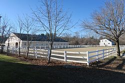
Painted Image Farm, East Candia NH.jpg

Painted Image Farm
USA New Hampshire location map.svg
Red pog.svg
East
Candia
Usa edcp location map.svg
Red pog.svg
East
Candia
Coordinates: 43°02′53″N71°14′59″W / 43.04806°N 71.24972°W / 43.04806; -71.24972 Coordinates: 43°02′53″N71°14′59″W / 43.04806°N 71.24972°W / 43.04806; -71.24972
Country United States
State New Hampshire
County Rockingham
Town Candia
Elevation 443 ft (135 m)
Time zone Eastern (EST) (UTC-5)
  Summer (DST) EDT (UTC-4)
ZIP code 03040
Area code(s) 603
GNIS feature ID 871261 [1]

East Candia is an unincorporated community in the town of Candia in Rockingham County, New Hampshire.

Unincorporated area Region of land not governed by own local government

In law, an unincorporated area is a region of land that is not governed by a local municipal corporation; similarly an unincorporated community is a settlement that is not governed by its own local municipal corporation, but rather is administered as part of larger administrative divisions, such as a township, parish, borough, county, city, canton, state, province or country. Occasionally, municipalities dissolve or disincorporate, which may happen if they become fiscally insolvent, and services become the responsibility of a higher administration. Widespread unincorporated communities and areas are a distinguishing feature of the United States and Canada. In most other countries of the world, there are either no unincorporated areas at all, or these are very rare; typically remote, outlying, sparsely populated or uninhabited areas.

Candia, New Hampshire Place in New Hampshire, United States

Candia is a town in Rockingham County, New Hampshire, United States. The population was 3,909 at the 2010 census. The town includes the villages of Candia, Candia Four Corners and East Candia.

Rockingham County, New Hampshire County in the United States

Rockingham County is a county in the U.S. state of New Hampshire. As of the 2010 census, the population was 295,223, making it the second-most populous county in New Hampshire. The county seat is Brentwood. Rockingham County constitutes a portion of the Boston-Cambridge-Newton, MA-NH Metropolitan Statistical Area as well as of the greater Boston-Worcester-Providence, MA-RI-NH-CT Combined Statistical Area.

The village, as the name suggests, is located in the eastern part of the town of Candia, close to the town border with Raymond. The community is centered upon the intersection of Langford Road and Depot Road, approximately 0.5 miles (0.8 km) south of Langford Road's intersection with New Hampshire Route 27.

Raymond, New Hampshire Place in New Hampshire, United States

Raymond is a town in Rockingham County, New Hampshire, United States. The population was 10,138 at the 2010 census, and the estimated population in 2017 was 10,376. Part of Pawtuckaway State Park is in the north.

New Hampshire Route 27 highway in New Hampshire

New Hampshire Route 27 is a 37.621-mile-long (60.545 km) long east–west highway in southeastern New Hampshire. The western terminus of NH 27 is in Hooksett at U.S. Route 3 and New Hampshire Route 28 north of Manchester. The eastern terminus is in Hampton Beach at New Hampshire Route 1A, which runs along the New Hampshire coastline adjacent to the Atlantic Ocean.

East Candia has a separate ZIP code (03040) from the rest of the town of Candia.

Related Research Articles

Raymond (CDP), New Hampshire Census-designated place in New Hampshire, United States

Raymond is a census-designated place (CDP) and the primary village in the town of Raymond in Rockingham County, New Hampshire, United States. The population of the CDP was 2,855 at the 2010 census, out of 10,138 people in the entire town of Raymond.

U.S. Route 302 is an east–west spur of U.S. Route 2 in northern New England in the United States. It currently runs 171 miles (275 km) from Montpelier, Vermont, beginning at US 2, to Portland, Maine, at U.S. Route 1. It passes through the states of Vermont, New Hampshire and Maine.

New Hampshire Route 10 highway in New Hampshire

New Hampshire Route 10 is a 122.25-mile-long (196.74 km) north–south state highway in western New Hampshire, United States. Its southern terminus is in Winchester at the Massachusetts state line, where it continues south as Massachusetts Route 10. Administratively, the northern terminus is at a junction with U.S. Route 302 in Haverhill.

New Hampshire Route 111 highway in New Hampshire

New Hampshire Route 111 is a 50.027-mile-long (80.511 km) east–west highway in Hillsborough and Rockingham counties in southeastern New Hampshire. The road runs from the Massachusetts border at Hollis to North Hampton on the Atlantic shore.

New Hampshire Route 101 highway in New Hampshire

New Hampshire Route 101 is a state-maintained highway in southern New Hampshire extending from Keene to Hampton Beach. It is the major east–west highway in the southern portion of the state.

New Hampshire Route 43 is a 16.418-mile-long (26.422 km) north–south state highway in southeastern New Hampshire which runs from Candia to Northwood. The southern terminus of NH 43 is at an interchange with New Hampshire Route 101 in Candia. The northern terminus is at an intersection with U.S. Route 4, U.S. Route 202 and New Hampshire Route 9 in Northwood.

New Hampshire Route 47 highway in New Hampshire

New Hampshire Route 47 is a 7.148-mile-long (11.504 km) state highway in southern New Hampshire. It runs from Francestown to Bennington. It is signed as a north–south route, but follows more of an east–west routing. In fact, during its "northernmost" (westernmost) 2.4 miles, it proceeds southwest while signed north.

New Hampshire Route 88 highway in New Hampshire

New Hampshire Route 88 is a 6.676-mile-long (10.744 km) east–west state highway in Rockingham County in southeastern New Hampshire, United States. It runs from Hampton Falls to Exeter.

New Hampshire Route 108 highway in New Hampshire and Massachusetts

New Hampshire Route 108 is a 42.430-mile-long (68.284 km) north–south state highway in Rockingham and Strafford counties in southeastern New Hampshire. The southern terminus of NH 108 is at the Massachusetts state line in Plaistow. The northern terminus is at an intersection with New Hampshire Route 125 and New Hampshire Route 202A in downtown Rochester.

New Hampshire Route 113 highway in New Hampshire

New Hampshire Route 113 is a 40.456-mile long (65.108 km) east–west state highway in east-central New Hampshire. NH 113 begins in the Lakes Region at an intersection with U.S. Route 3 and New Hampshire Route 25 in Holderness, and stretches eastward across the central part of the state, ending at an intersection with U.S. Route 302 in Conway, just a few miles west of the Maine border.

New Hampshire Route 119 highway in New Hampshire

New Hampshire Route 119 is a state highway in the U.S. state of New Hampshire. The highway begins in Hinsdale at the Connecticut River, across which the highway continues into Brattleboro, Vermont, as Vermont Route 119 for 0.080 miles (0.129 km) to its terminus at U.S. Route 5 and VT 142. NH 119 heads east 39.908 miles (64.226 km) to the Massachusetts state line in New Ipswich, where the highway continues as Massachusetts Route 119. The state highway is the main east–west highway of southern Cheshire County, where it connects the towns of Hinsdale, Winchester, Richmond, Fitzwilliam, and Rindge.

New Hampshire Route 123 highway in New Hampshire

New Hampshire Route 123 is a 63.055-mile-long (101.477 km) secondary north–south state highway in southwestern New Hampshire. The southern terminus of the route is at the Massachusetts state line in Mason where, as Mason Road, the road continues as an unnumbered local road in the town of Townsend. The northern terminus, as signed, is at the Connecticut River, where the highway continues west for 0.313 miles (0.504 km) to U.S. Route 5 in Westminster, Vermont, as Vermont Route 123. Route logs, however, place the terminus at New Hampshire Route 12 in Walpole.

New Hampshire Route 175 highway in New Hampshire

New Hampshire Route 175 is a state highway in the U.S. state of New Hampshire. The highway runs north 25.261 miles (40.654 km) from an intersection in Holderness with U.S. Route 3 and New Hampshire Route 25 to an intersection with US 3 in Woodstock.

New York State Route 249 highway in New York

New York State Route 249 (NY 249) is a 13.50-mile (21.73 km) long state highway located within Erie County, New York, in the United States. It runs east–west across southwestern Erie County from the shores of Lake Erie in the village of Farnham to the hamlet of Langford in the town of North Collins. The route was designated as NY 249 in the 1930 renumbering of state highways in New York from Farnham to the village of North Collins. By the next year, the route was extended to its current length.

Candia Four Corners, New Hampshire Unincorporated community in New Hampshire, United States

The Candia Four Corners is an unincorporated community located near the center of the town of Candia, New Hampshire, in the United States.

Bear Brook is a 10.0-mile-long (16.1 km) stream located in central New Hampshire in the United States. It is a tributary of the Suncook River, part of the Merrimack River watershed. Its entire course is within Bear Brook State Park.

East Hampstead, New Hampshire Unincorporated community in New Hampshire, United States

East Hampstead is an unincorporated community in the town of Hampstead in Rockingham County, New Hampshire, United States.

East Lempster, New Hampshire Unincorporated community in New Hampshire, United States

East Lempster is an unincorporated community in the town of Lempster in Sullivan County, New Hampshire, United States.

References