North Hampton is a town in Rockingham County, New Hampshire, United States. The population was 4,538 at the 2020 census. While the majority of the town is inland, North Hampton includes a part of New Hampshire's limited Atlantic seacoast.

Rye is a town in Rockingham County, New Hampshire, United States. The population was 5,543 at the 2020 census. The town is home to several state parks along the Atlantic coastline.

Salisbury is a small coastal beach town and summer tourist destination in Essex County, Massachusetts, United States. The community is a popular summer resort beach town situated on the Atlantic Ocean, north of Boston on the New Hampshire border. It is home to the new Salisbury Beach Boardwalk, full of souvenir shops, restaurants, cafes, arcades and panoramic views of the Atlantic Ocean. The population was 9,236 at the 2020 census. Parts of town comprise the census-designated place of Salisbury.

The Seacoast Region is the southeast area of the U.S. state of New Hampshire that is centered around the city of Portsmouth. It includes the eastern portion of Rockingham County and the southern portion of Strafford County. At its narrowest definition, the region stretches 13 miles (21 km) along the Atlantic Ocean from New Hampshire's border with Salisbury, Massachusetts, to the Piscataqua River and New Hampshire's border with Kittery, Maine. The shoreline alternates between rocky and rough headlands and areas with sandy beaches. Some of the beaches are bordered by jetties or groins, particularly in the towns of Rye and Hampton. Most definitions of the Seacoast Region includes some inland towns as well, including the Great Bay area cities of Dover and Rochester, the college town of Durham, and areas as far west as Epping. Some definitions also include nearby portions of York County, Maine that are culturally aligned with the Portsmouth area rather than the Portland, Maine metropolitan area.

Waterville, historically known as Coirean, is a village in County Kerry, Ireland, on the Iveragh Peninsula. The town is sited on a narrow isthmus, with Lough Currane on the east side of the town, and Ballinskelligs Bay on the west, and the Currane River connecting the two.

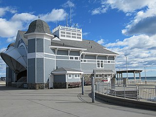
Hampton Beach is a village district, census-designated place, and beach resort in the town of Hampton, New Hampshire, United States, along the Atlantic Ocean. Its population at the 2020 census was 2,598. Hampton Beach is in Rockingham County, about 15 miles (24 km) south of Portsmouth. The community is a popular tourist destination and the busiest beach community in New Hampshire. Ocean Boulevard, the main street along the beach, includes a boardwalk, many shops and businesses, several seasonal hotels, and the Hampton Beach Casino Ballroom, which hosts national acts in the summer. Hampton Beach State Park was named one of four "Superstar" beaches in the United States in 2011, for having had perfect water-quality testing results in each of the previous three years.

New Hampshire Route 1A is an 18.32-mile (29.48 km) long state highway located in southeast New Hampshire. The route runs along the Atlantic coastline from the Massachusetts border north to Rye, then turns toward downtown Portsmouth. The southern terminus is at the Massachusetts state line in Seabrook where it continues south as Massachusetts Route 1A. The northern terminus is at a junction with U.S. Route 1 in downtown Portsmouth. For the length of the road's run along the shore, its local name is Ocean Boulevard. In the northern part of Rye, it is known as Pioneer Road, and in Portsmouth, it is known as Miller Avenue and Sagamore Avenue.
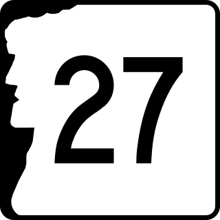
New Hampshire Route 27 is a 37.621-mile-long (60.545 km) long east–west highway in southeastern New Hampshire. The western terminus of NH 27 is in Hooksett at U.S. Route 3 and New Hampshire Route 28 north of Manchester. The eastern terminus is in Hampton Beach at New Hampshire Route 1A, which runs along the New Hampshire coastline adjacent to the Atlantic Ocean.

Ballinskelligs, officially Baile an Sceilg, is a townland in the civil parish of Prior, County Kerry, Ireland. It may also refer to the wider district around the townland. It is located in the south-west of the Iveragh peninsula and is within the Gaeltacht. According to the 2016 census about 10% of the population of the electoral division speak Irish on a daily basis outside the education system. The townland was in the Poor law union of Cahersiveen.

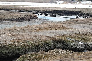
The Sunken Forests of New Hampshire are two areas of petrified tree stumps submerged off the coast of Rye, New Hampshire, United States.

The CS Faraday was a cable ship built for Siemens Brothers and launched in 1874.

Wallis Sands State Beach is a public recreation area located on the Atlantic Ocean in the town of Rye, New Hampshire. The state park offers a sandy beach with bathhouse, picnicking, and 500-car pay-parking lot.

Odiorne Point State Park is a public recreation area located on the Atlantic seacoast in the town of Rye near Portsmouth, New Hampshire. Among the park's features are the Seacoast Science Center and the remains of the World War II Fort Dearborn. The park offers opportunities for hiking, cycling, picnicking, fishing, and boating.
Tor Bay is a small fishing community in the Canadian province of Nova Scotia, located in the Municipality of the District of Guysborough in Guysborough County. It is located at the south-western end of a bay of the same name.

St. Andrew's-by-the-Sea is a historic Episcopal chapel on Church Road, southeast of the junction with South Road and Route 1A in Rye, New Hampshire. Built in 1876, it is the only known religious work of Boston architects Winslow & Wetherell, and one of a modest number of churches built for summer vacationers in the state. It is an eclectic mix of Gothic Revival and Stick Style, and was listed on the National Register of Historic Places in 2001.
Hampton Beach State Park is a 50-acre (20 ha) state park in the community of Hampton Beach, New Hampshire, United States. It is located on the southeastern edge of New Hampshire on a peninsula where the Hampton River meets the Atlantic Ocean. Ocean Boulevard forms the western edge of the park.

The Beach Club is a private oceanfront club at 2450 Ocean Boulevard in Rye, New Hampshire. Founded in 1925, it is the only beachfront private club to survive from the early 20th century along New Hampshire's coast. It was listed on the National Register of Historic Places in 2013.
Jenness State Beach is a small state park located on the Atlantic Ocean in the town of Rye, New Hampshire. The park offers swimming at a sandy beach with a bathhouse and picnicking. The parking lot can accommodate 67 cars.
Rye Harbor State Park is a public recreation area located on the Atlantic Ocean in the town of Rye, New Hampshire. The portion of the state park located on the peninsula known as Ragged Neck offers scenic views of the ocean, the Isles of Shoals, and the town harbor. Activities include saltwater fishing and picnicking. Amenities include benches, picnic tables, pavilion, and restrooms.