Chester, New Hampshire

Last updated

Chester, New Hampshire
ChesterNH StevensMemorialHall.jpg
Seal of Chester, New Hampshire.svg
Rockingham County New Hampshire incorporated and unincorporated areas Chester highlighted.svg
Location in Rockingham County and the state of New Hampshire.
Coordinates: 42°57′24″N71°15′26″W / 42.95667°N 71.25722°W / 42.95667; -71.25722
Country United States
State New Hampshire
County Rockingham
Incorporated 1722
Government
   Board of Selectmen
  • Chuck Myette, Chair
  • Steven M. Couture, Vice-Chair
  • Stephen O. Landau
  • Dana Theokas
  • Richard S. Trask
  Town AdministratorDebra H. Doda
Area
[1]
  Total26.1 sq mi (67.7 km2)
  Land26.0 sq mi (67.4 km2)
  Water0.1 sq mi (0.3 km2)  0.43%
Elevation
467 ft (142 m)
Population
 (2020) [2]
  Total5,232
  Density201/sq mi (77.7/km2)
Time zone UTC-5 (Eastern)
  Summer (DST) UTC-4 (Eastern)
ZIP code
03036
Area code 603
FIPS code 33-12100
GNIS feature ID0873564
Website www.chesternh.org

Chester is a town in Rockingham County, New Hampshire, United States. The population was 5,232 at the 2020 census, [2] up from 4,768 at the 2010 census. [3] It was home to the now defunct Chester College (formerly White Pines College).

Contents

History

From Statistics and Gazetteer of New-Hampshire, 1875:

"Chester is considered one of the old towns of the state. In 1719, about eighty persons, chiefly from Portsmouth and Hampton, formed an association, for the purpose of securing a tract of land in the "Chesnut Country" (so called) and stationed three men upon this tract, to hold possession until they should procure a lawful title. After considerable difficulty they obtained a grant of land, ten miles [16 km] square. Immediately the settlement was commenced by several persons from Rye and Hampton, among whom were Samuel Ingalls, Jonathan Goodhue, Jacob Sargent, Ebenezer Dearborn, Robert Smith, E. Colby and S. Robie, who contributed largely to the permanent success of the enterprise. On the 8th of May, 1722 the township which had hitherto been called Cheshire, was incorporated under its present name, and comprising an area of over 120 square miles [310 km2]." [4]

Chester once included Candia, set off in 1763. It may have been the first of the settlement grants by Massachusetts selected for expansion of growing populations in the seacoast. The name may be derived from Chester, the county town of the county of Cheshire in England. Earl of Chester is a title held by the Prince of Wales.

In 1822, a portion of Hooksett was taken from Chester. In 1845, the portion of the town known as Long Meadows was incorporated under the name of Auburn. [4]
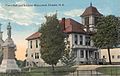
Geography

According to the United States Census Bureau, the town has a total area of 26.1 square miles (67.7 km2), of which 26.0 square miles (67.4 km2) are land and 0.12 square miles (0.3 km2), or 0.43%, are water. [1] The highest point in town is found on an unnamed hill west of Bell Hill and northwest of Harantis Lake; it has two knobs of almost equal elevation of at least 635 feet (194 m), according to the most recent (2011–2012) USGS 7.5-minute topographical map. [5] The Exeter River rises in Chester. The area of Chester drained by the Exeter and its tributary Towle Brook lies within the Piscataqua River (Coastal) watershed, while the western edge of town drains west toward Massabesic Lake and is in the Merrimack River watershed. [6]

Adjacent municipalities

Demographics

Historical population
CensusPop.Note
1790 1,902
1800 2,0467.6%
1810 2,030−0.8%
1820 2,26211.4%
1830 2,039−9.9%
1840 1,304−36.0%
1850 1,301−0.2%
1860 1,275−2.0%
1870 1,153−9.6%
1880 1,136−1.5%
1890 958−15.7%
1900 861−10.1%
1910 818−5.0%
1920 652−20.3%
1930 6530.2%
1940 7027.5%
1950 80715.0%
1960 1,05330.5%
1970 1,38231.2%
1980 2,00645.2%
1990 2,69134.1%
2000 3,79240.9%
2010 4,76825.7%
2020 5,2329.7%
U.S. Decennial Census [2] [7]
The Common c. 1910 The Common, Chester, NH.jpg
The Common c.1910

As of the census [8] of 2000, there were 3,792 people, 1,214 households, and 1,011 families residing in the town. The population density was 146.4 inhabitants per square mile (56.5/km2). There were 1,247 housing units at an average density of 48.1 per square mile (18.6/km2). The racial makeup of the town was 97.97% White, 0.26% African American, 0.42% Native American, 0.32% Asian, 0.16% from other races, and 0.87% from two or more races. Hispanic or Latino of any race were 0.82% of the population.

There were 1,214 households, out of which 45.0% had children under the age of 18 living with them, 73.3% were married couples living together, 6.6% had a female householder with no husband present, and 16.7% were non-families. 11.8% of all households were made up of individuals, and 4.3% had someone living alone who was 65 years of age or older. The average household size was 3.09 and the average family size was 3.38.

In the town, the population was spread out, with 31.0% under the age of 18, 6.3% from 18 to 24, 32.1% from 25 to 44, 24.6% from 45 to 64, and 6.1% who were 65 years of age or older. The median age was 36 years. For every 100 females, there were 97.8 males. For every 100 females age 18 and over, there were 94.4 males.

The median income for a household in the town was $68,571, and the median income for a family was $75,092. Males had a median income of $44,056 versus $35,382 for females. The per capita income for the town was $23,842. About 3.4% of families and 5.0% of the population were below the poverty line, including 5.9% of those under age 18 and 5.2% of those age 65 or over.

Education

Elementary and middle school students attend Chester Academy (public). [9] High school students attend Pinkerton Academy in Derry, a privately operated school that contracts with the towns of Derry, Auburn, Chester, Candia, Hooksett, and Hampstead. [10]

Transportation

Three New Hampshire state routes cross Chester.

Notable people

Related Research Articles

<span class="mw-page-title-main">Rockingham County, New Hampshire</span> County in New Hampshire, United States

Rockingham County is a county in the U.S. state of New Hampshire. As of the 2020 census, the population was 314,176, making it New Hampshire's second-most populous county. The county seat is Brentwood. Rockingham County is part of the Boston-Cambridge-Newton, MA-NH Metropolitan Statistical Area and the greater Boston-Worcester-Providence, MA-RI-NH-CT Combined Statistical Area. Per the 2020 census, it was New Hampshire's fastest growing county from 2010 to 2020.

<span class="mw-page-title-main">Gilmanton, New Hampshire</span> Town in New Hampshire, United States

Gilmanton is a town in Belknap County, New Hampshire, United States. The population was 3,945 at the 2020 census. Gilmanton includes the villages of Gilmanton Corners and Gilmanton Ironworks. The town became well known in the 1950s after it was rumored that the popular novel Peyton Place, written by resident Grace Metalious, was based on the town.

<span class="mw-page-title-main">Canaan, New Hampshire</span> Town in New Hampshire, United States

Canaan is a town in Grafton County, New Hampshire, United States. The population was 3,794 at the 2020 census. It is the location of Mascoma State Forest. Canaan is home to the Cardigan Mountain School, the town's largest employer.

<span class="mw-page-title-main">Orford, New Hampshire</span> Town in New Hampshire, United States

Orford is a town in Grafton County, New Hampshire, United States. The population was 1,237 at the 2020 census, unchanged from the 2010 census. The Appalachian Trail crosses in the east.

<span class="mw-page-title-main">Amherst, New Hampshire</span> Town in New Hampshire, United States

Amherst is a town in Hillsborough County in the state of New Hampshire, United States. The population was 11,753 at the 2020 census. Amherst is home to Ponemah Bog Wildlife Sanctuary, Hodgman State Forest, the Joe English Reservation and Baboosic Lake.

<span class="mw-page-title-main">Francestown, New Hampshire</span> Town in New Hampshire, United States

Francestown is a town in Hillsborough County, New Hampshire, United States. The population was 1,610 at the 2020 census. The village of Francestown, population 201 in 2020, is in the center of the town.

<span class="mw-page-title-main">Allenstown, New Hampshire</span> Town in New Hampshire, United States

Allenstown is a town in Merrimack County, New Hampshire, United States. The population was 4,707 at the 2020 census, up from 4,322 at the 2010 census. Allenstown includes a portion of the village of Suncook. Just over one-half of the town's area is covered by Bear Brook State Park.

<span class="mw-page-title-main">Canterbury, New Hampshire</span> Town in New Hampshire, United States

Canterbury is a town in Merrimack County, New Hampshire, United States. The population was 2,389 at the 2020 census. The Canterbury Shaker Village is in the eastern part of the town.

<span class="mw-page-title-main">South Hooksett, New Hampshire</span> Census-designated place in New Hampshire, United States

South Hooksett is a census-designated place (CDP) within the town of Hooksett in Merrimack County, New Hampshire, United States. The population was 5,888 at the 2020 census. It is a suburban area adjacent to the city of Manchester, New Hampshire's largest city, and includes a mix of housing developments and large retail stores.

<span class="mw-page-title-main">Auburn, New Hampshire</span> Place in New Hampshire, United States

Auburn is a town in Rockingham County, New Hampshire, United States. The population was 5,946 at the 2020 census, up from 4,953 at the 2010 census.

<span class="mw-page-title-main">Candia, New Hampshire</span> Place in New Hampshire, United States

Candia is a town in Rockingham County, New Hampshire, United States. The population was 4,013 at the 2020 census. The town includes the villages of Candia, Candia Four Corners and East Candia.

<span class="mw-page-title-main">Deerfield, New Hampshire</span> Town in New Hampshire, United States

Deerfield is a town in Rockingham County, New Hampshire, United States. The population was 4,855 at the 2020 census, an increase over the figure of 4,280 tabulated in 2010. Deerfield is the location of the annual Deerfield Fair.

<span class="mw-page-title-main">Hampstead, New Hampshire</span> Place in New Hampshire, United States

Hampstead is a town in Rockingham County, New Hampshire, United States. The population was 8,998 at the 2020 census. Hampstead, which includes the village of East Hampstead, is home to a portion of the Rockingham Recreational Trail.

<span class="mw-page-title-main">Sandown, New Hampshire</span> Town in New Hampshire, United States

Sandown is a town in Rockingham County, New Hampshire, United States. The population was 6,548 at the 2020 census, up from 5,986 at the 2010 census.

<span class="mw-page-title-main">Stratham, New Hampshire</span> Town in New Hampshire, United States

Stratham is a town in Rockingham County, New Hampshire, United States. The town had a population of 7,669 at the 2020 census. It is bounded on the west by the Squamscott River. The town is the home of the only U.S. Lindt & Sprüngli factory and the headquarters of the Timberland Corporation.

<span class="mw-page-title-main">Hooksett, New Hampshire</span> Town in New Hampshire, United States

Hooksett is a town in Merrimack County, New Hampshire, United States. The population was 14,871 at the 2020 census, up from 13,451 at the 2010 census. The town is located between Manchester, the state's largest city, and Concord, the state capital. A prominent landmark is Robie's Country Store, a National Historic Landmark and a frequent stop for presidential candidates during the New Hampshire primary.

<span class="mw-page-title-main">Derry (CDP), New Hampshire</span> Census-designated place in New Hampshire, United States

Derry is a census-designated place (CDP) in the town of Derry in Rockingham County, New Hampshire, United States. The CDP comprises the urban center of the town, as well as the village of East Derry and connected suburban areas. The population of the CDP was 22,879 at the 2020 census, out of 34,317 in the entire town.

<span class="mw-page-title-main">Londonderry, New Hampshire</span> Town in Rockingham County, New Hampshire, United States of America

Londonderry is a town in western Rockingham County, New Hampshire, United States. It sits between Manchester and Derry, the largest and fourth-largest communities in the state. The population was 25,826 at the 2020 census. Londonderry is known for its apple orchards and is home to the headquarters of Stonyfield Farm and part of Manchester–Boston Regional Airport.

<span class="mw-page-title-main">Derry, New Hampshire</span> Town in New Hampshire, United States

Derry is a town in Rockingham County, New Hampshire, United States. The population was 34,317 at the 2020 census. Although it is a town and not a city, Derry is the most populous community in Rockingham County and the 4th most populous in the state. The town's nickname, "Spacetown", derives from the fact that Derry is the birthplace of Alan Shepard, the first astronaut from the United States in space. Derry was also for a time the home of the poet Robert Frost and his family.

<span class="mw-page-title-main">Pinkerton Academy</span> Secondary school in Derry, New Hampshire, USA

Pinkerton Academy is a secondary school in Derry, New Hampshire, United States. It serves roughly 3,269 students, making it by far the largest high school in New Hampshire, more than 1,300 students greater than the next largest high school. Pinkerton's situation is unusual, as it is a privately-incorporated school that serves as the public high school for the communities of Derry, Hampstead, Chester, Auburn, Candia, and Hooksett. Through arrangements with the towns, each town pays the tuition for their students to attend Pinkerton. Pinkerton Academy is a private, non-profit corporation administered by a headmaster who acts under the direction of an elected board of trustees.

References

  1. 1 2 "2021 U.S. Gazetteer Files – New Hampshire". United States Census Bureau. Retrieved December 20, 2021.
  2. 1 2 3 "Chester town, Rockingham County, New Hampshire: 2020 DEC Redistricting Data (PL 94-171)". U.S. Census Bureau. Retrieved December 20, 2021.
  3. United States Census Bureau, U.S. Census website, 2010 Census figures. Retrieved March 23, 2011.
  4. 1 2 Article in Statistics and Gazetteer of New-Hampshire (1875)
  5. "Archived copy". Archived from the original on January 13, 2016. Retrieved March 30, 2014.{{cite web}}: CS1 maint: archived copy as title (link)
  6. Foster, Debra H.; Batorfalvy, Tatianna N.; Medalie, Laura (1995). Water Use in New Hampshire: An Activities Guide for Teachers. U.S. Department of the Interior and U.S. Geological Survey.
  7. "Census of Population and Housing". Census.gov. Retrieved June 4, 2016.
  8. "U.S. Census website". United States Census Bureau . Retrieved January 31, 2008.
  9. "Home". Chester Academy. Retrieved April 24, 2022.
  10. "Sending towns". Pinkerton Academy . Retrieved April 24, 2022.
  11. "BELL, Charles Henry, (1823 - 1893)". Biographical Directory of the United States Congress. Retrieved January 22, 2014.
  12. "Notable People". Chester Historical Society. Retrieved January 22, 2014.
  13. "BELL, Samuel, (1770 - 1850)". Biographical Directory of the United States Congress. Retrieved January 14, 2014.
  14. "BELL, Samuel, (1770 - 1850)". Biographical Directory of the United States Congress. Retrieved January 22, 2014.
  15. 1 2 "Notable People". Chester Historical Society. Retrieved January 22, 2014.
  16. "HAZELTON, George Cochrane, (1832 - 1922". Biographical Directory of the United States Congress. Retrieved January 22, 2014.
  17. "HAZELTON, Gerry Whiting, (1829 - 1920)". Biographical Directory of the United States Congress. Retrieved January 22, 2014.
  18. "LIVERMORE, Arthur, (1766 - 1853)". Biographical Directory of the United States Congress. Retrieved January 14, 2014.