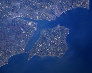
The Solent is a strait between the Isle of Wight and mainland Great Britain; the major historic ports of Southampton and Portsmouth lie inland of its shores. It is about 20 miles long and varies in width between 2+1⁄2 and 5 mi, although the Hurst Spit which projects 1+1⁄2 mi (2.4 km) into the Solent narrows the sea crossing between Hurst Castle and Colwell Bay to just over 1 mi (1.6 km).
North Hampton is a town in Rockingham County, New Hampshire, United States. The population was 4,538 at the 2020 census. While the majority of the town is inland, North Hampton includes a part of New Hampshire's limited Atlantic seacoast.

Rye is a town in Rockingham County, New Hampshire, United States. The population was 5,543 at the 2020 census. The town is home to several state parks along the Atlantic coastline.

Borth is a village and seaside resort in Ceredigion, Mid Wales; it is located 7 miles (11 km) north of Aberystwyth, on the Ceredigion Coast Path. The community includes the settlement of Ynyslas and the population was 1,399 in 2011. From being largely Welsh-speaking, the village has become anglicised; over 54 per cent of its residents were born in England. According to both the 1991 and 2001 censuses, 43 per cent of the residents of Borth were primarily Welsh-speakers.

In oceanography, geomorphology, and geoscience, a shoal is a natural submerged ridge, bank, or bar that consists of, or is covered by, sand or other unconsolidated material and rises from the bed of a body of water to close or above the surface that poses a danger to navigation. Shoals are also known as sandbanks, sandbars, or gravelbars. Two or more shoals that are either separated by shared troughs or interconnected by past or present sedimentary and hydrographic processes are referred to as a shoal complex.

New Hampshire Route 1A is an 18.32-mile (29.48 km) long state highway located in southeast New Hampshire. The route runs along the Atlantic coastline from the Massachusetts border north to Rye, then turns toward downtown Portsmouth. The southern terminus is at the Massachusetts state line in Seabrook where it continues south as Massachusetts Route 1A. The northern terminus is at a junction with U.S. Route 1 in downtown Portsmouth. For the length of the road's run along the shore, its local name is Ocean Boulevard. In the northern part of Rye, it is known as Pioneer Road, and in Portsmouth, it is known as Miller Avenue and Sagamore Avenue.

The 1944 Great Atlantic hurricane was a destructive and powerful tropical cyclone that swept across a large portion of the United States East Coast in September 1944. New England was most affected, though so were the Outer Banks, Mid-Atlantic states, and the Canadian Maritimes. The storm's ferocity and path drew comparisons to the 1938 Long Island Express, one of the worst storms in New England history.

Portsmouth International Airport at Pease, formerly known as Pease International Airport, is a joint civil and military use airport located one nautical mile (2 km) west of the central business district of Portsmouth, a city in Rockingham County, New Hampshire, United States. It is owned by the Pease Development Authority. It is included in the Federal Aviation Administration (FAA) National Plan of Integrated Airport Systems for 2017–2021, in which it is categorized as a non-hub primary commercial service facility.

Pett is a village and civil parish in the Rother district of East Sussex, England. The village is located 5 miles (8.0 km) north-east of Hastings on the edge of Pett Level, the one-time marshes stretching along the coast of Rye Bay.

Pease Air National Guard Base is a New Hampshire Air National Guard base located at Portsmouth International Airport at Pease in New Hampshire. It occupies a portion of what was once Pease Air Force Base, a former Strategic Air Command facility with a base-related population of 10,000 and which was home to the 509th Bomb Wing flying the General Dynamics FB-111A. Pease AFB was closed pursuant to 1991 Base Realignment and Closure Commission action, with the 509 BW transferring to Whiteman AFB, Missouri. In 1983, investigations had shown soil and water contamination with degreasers and JP-4 jet fuel, and in 1990 the base was put on the National Priorities List of superfund sites. As of 2015, after 25 years of the Pease Development Authority's work, Pease International Tradeport has 275 businesses employing close to 10,000 civilian workers.

Cantre'r Gwaelod, also known as Cantref Gwaelod or Cantref y Gwaelod, is a legendary ancient sunken kingdom said to have occupied a tract of fertile land lying between Ramsey Island and Bardsey Island in what is now Cardigan Bay to the west of Wales. It has been described as a "Welsh Atlantis" and has featured in folklore, literature, and song.

Rye Beach is an unincorporated community along the Atlantic Ocean in Rye, New Hampshire, United States. It is located along New Hampshire Route 1A near the southern border of the town of Rye, directly south of Jenness State Beach and north of Little Boar's Head. Rye Beach has a separate ZIP code (03871) from the rest of the town of Rye.
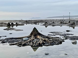
A submerged forest is the in situ remains of trees, especially tree stumps, that lie submerged beneath a bay, sea, ocean, lake, or other body of water. These remains have usually been buried in mud, peat, or sand for several thousand years before being uncovered by sea level change and erosion and have been preserved in the compacted sediment by the exclusion of oxygen. A forest can become submerged as the result of a lake or sea level rise that results in a lacustrine or marine transgression and in-place drowning of the forest. A submerged forest that lies beneath a lake can also be formed by the blockage of a river valley by either a landslide or manmade dam.

The Neskowin Ghost Forest is the remnants of a Sitka spruce forest on the Oregon Coast of the United States. The stumps were likely created when an earthquake of the Cascadia subduction zone abruptly lowered the trees, that were then covered by mud from landslides or debris from a tsunami. Many of the stumps are over 2,000 years old.
The 1842 Atlantic hurricane season featured several maritime catastrophes in the Gulf of Mexico and along the U.S. East Coast, and produced one of the only known tropical cyclones to directly affect the Iberian Peninsula. As the season falls outside the scope of the Atlantic hurricane database, records of most storms in 1842 are scarce, and only approximate tracks are known. The first documented storm of the season battered the coast of North Carolina in mid-July, wrecking dozens of ships and destroying homes along the Outer Banks. A little over a month later, another storm impacted the same region and caused several more shipwrecks that killed at least 12 men. This storm later doused the Mid-Atlantic states with flooding rains. In early September, a powerful storm known as "Antje's Hurricane"—named after a ship that it dismasted—tracked generally westward after first being spotted over the Leeward Islands. After yielding widespread destruction across the Bahamas, the storm traversed the Florida Straits, causing severe damage in both northern Cuba and the lower Florida Keys. Many ships and their crews were lost to the storm as it crossed the Gulf of Mexico; it finally struck northern Mexico on September 8.
The 1827 North Carolina hurricane caused severe impacts along its track through the northeastern Caribbean Sea and up the East Coast of the United States in late August 1827. First observed over the Leeward Islands on August 17, the storm continued northwest, passing over Puerto Rico and the northern coastline of Hispaniola. It moved through the Turks and Caicos Islands and then the Bahamas by August 21 and curved northward. Although there is some discrepancy in its track, the hurricane moved ashore somewhere along the North Carolina coastline on August 25, perhaps at Category 4 intensity on the modern-day Saffir–Simpson hurricane wind scale. The cyclone emerged back into the Atlantic Ocean around Norfolk, Virginia, and grazed the New England coastline before last being observed offshore Nova Scotia on August 28. Along its track, numerous vessels were damaged, capsized, or run aground. The combination of heavy rainfall and ferocious winds caused severe crop damage, damaged or destroyed structures, and snapped and uprooted trees. Overall, the storm was responsible for more than six deaths and at least two injuries.
