Sanbornton, New Hampshire

Last updated

Sanbornton, New Hampshire
Town
Sanbornton Square.jpg
Sanbornton Square Historic District
Sanbornton NH Town Seal.png
Belknap-Sandbornton-NH.png
Coordinates: 43°29′28″N71°35′01″W / 43.49111°N 71.58361°W / 43.49111; -71.58361
Country United States
State New Hampshire
County Belknap
Incorporated 1770
Villages
  • Bay Meetinghouse
  • Gaza
  • North Sanbornton
  • Sanbornton
  • Winnisquam
Government
   Board of Selectmen
  • Bob Lambert
  • Brandon Deacon
  • Glenn Frederick
  Town AdministratorTrish Stafford
Area
[1]
  Total49.7 sq mi (128.6 km2)
  Land47.4 sq mi (122.7 km2)
  Water2.3 sq mi (5.9 km2)  4.58%
Elevation
824 ft (251 m)
Population
 (2020) [2]
  Total3,026
  Density64/sq mi (24.7/km2)
Time zone UTC-5 (Eastern)
  Summer (DST) UTC-4 (Eastern)
ZIP code
03269
Area code 603
FIPS code33-67300
GNIS feature ID0873715
Website www.sanborntonnh.org

Sanbornton is a town in Belknap County, New Hampshire, United States. The population was 3,026 at the 2020 census. [2] It includes the villages of North Sanbornton and Gaza.

Contents

History

Located in the fork of the Pemigewasset and Winnipesaukee rivers, the town was first called "Crotchtown". It was granted by colonial Governor Benning Wentworth in 1748 to his friend John Sanborn of Hampton, along with 59 others from Hampton, Exeter and Stratham. Twelve of the grantees were named Sanborn, therefore the community was named "Sanborntown". [3] Among the other settlers were members of the Leavitt family, related to the Sanborns. [4] But ongoing hostilities during the French and Indian War delayed permanent settlement until 1764. It would be incorporated by Governor John Wentworth in 1770.

There was a border adjustment to Merrimack and Strafford counties on December 24, 1828, that affected Northfield and Sanborntown. [5] The town originally included Sanbornton Bridge, or Bridge Village, set off in 1869 as Tilton.

Geography

According to the United States Census Bureau, the town has a total area of 49.7 square miles (128.6 km2), of which 47.4 sq mi (122.7 km2) are land and 2.3 sq mi (5.9 km2) are water, comprising 4.58% of the town. [1] Bounded on the west by the Pemigewasset River and on the east by Lake Winnisquam, Sanbornton is largely drained by Salmon Brook, a tributary of the Pemigewasset. The highest point in town is the summit of Hersey Mountain, elevation 2,001 feet (610 m) above sea level, along the town's northwestern border.

The town is served by Interstate 93, New Hampshire Route 132, and New Hampshire Route 127. I-93 accesses the town via Exit 22 (NH 127) and leads north to Plymouth and south to Concord. NH 132 parallels I-93 as a local road, connecting Tilton to the south with New Hampton and Ashland to the north. NH 127 intersects NH 132 in the village of Gaza within Sanbornton and leads southwest to Franklin. U.S. Route 3 crosses a very small southeastern corner of Sanbornton at the village of Winnisquam, where the road crosses Lake Winnisquam.

Adjacent municipalities

Demographics

Historical population
CensusPop.Note
1790 1,587
1800 2,69569.8%
1810 2,8847.0%
1820 3,32915.4%
1830 2,866−13.9%
1840 2,745−4.2%
1850 2,695−1.8%
1860 2,7431.8%
1870 1,236−54.9%
1880 1,192−3.6%
1890 1,027−13.8%
1900 944−8.1%
1910 850−10.0%
1920 617−27.4%
1930 6546.0%
1940 6773.5%
1950 75511.5%
1960 85713.5%
1970 1,02219.3%
1980 1,67964.3%
1990 2,13627.2%
2000 2,58120.8%
2010 2,96614.9%
2020 3,0262.0%
U.S. Decennial Census [2] [6]

As of the 2000 census, [7] there were 2,581 people, 969 households, and 749 families residing in the town. The population density was 54.3 inhabitants per square mile (21.0/km2). There were 1,359 housing units at an average density of 28.6 per square mile (11.0/km2). The racial makeup of the town was 98.14% White, 0.15% African American, 0.15% Native American, 0.50% Asian, 0.12% from other races, and 0.93% from two or more races. Hispanic or Latino of any race were 0.43% of the population.

There were 969 households, out of which 33.0% had children under the age of 18 living with them, 64.7% were married couples living together, 8.9% had a female householder with no husband present, and 22.7% were non-families. 16.8% of all households were made up of individuals, and 6.5% had someone living alone who was 65 years of age or older. The average household size was 2.66 and the average family size was 2.97.

In the town, the population was spread out, with 25.3% under the age of 18, 6.4% from 18 to 24, 28.9% from 25 to 44, 28.4% from 45 to 64, and 10.9% who were 65 years of age or older. The median age was 40 years. For every 100 females, there were 98.4 males. For every 100 females age 18 and over, there were 97.5 males.

The median income for a household in the town was $48,458, and the median income for a family was $52,179. Males had a median income of $35,472 versus $26,117 for females. The per capita income for the town was $22,879. About 2.2% of families and 5.1% of the population were below the poverty line, including 8.4% of those under age 18 and 4.3% of those age 65 or over.

Government

In the New Hampshire Senate, Sanbornton is in the 2nd district, represented by Republican Bob Giuda. On the New Hampshire Executive Council, Sanbornton is in the 1st district, represented by Republican Joseph Kenney. In the United States House of Representatives, Sanbornton is in New Hampshire's 1st congressional district, represented by Democrat Chris Pappas.

Notable people

Related Research Articles

<span class="mw-page-title-main">Belknap County, New Hampshire</span> County in New Hampshire, United States

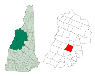
Belknap County is a county in the U.S. state of New Hampshire. As of the 2020 census, the population was 63,705. The county seat is Laconia. It is located in New Hampshire's Lakes Region, slightly southeast of the state's geographic center. Belknap County comprises the Laconia, NH Micropolitan Statistical Area, which in turn constitutes a portion of the Boston-Worcester-Providence, MA-RI-NH-CT Combined Statistical Area.

<span class="mw-page-title-main">Belmont, New Hampshire</span> Town in New Hampshire, United States

Belmont is a town in Belknap County, New Hampshire, United States. The population was 7,314 at the 2020 census.

<span class="mw-page-title-main">Gilford, New Hampshire</span> Town in New Hampshire, United States

Gilford is a town in Belknap County, New Hampshire, United States. The population was 7,699 at the 2020 census, up from 7,126 at the 2010 census. Situated on Lake Winnipesaukee, Gilford is home to Governors Island, Ellacoya State Beach, Belknap Mountain State Forest, Gunstock Mountain Resort, and the Bank of New Hampshire Pavilion, a seasonal outdoor concert venue. The lakeside village of Glendale lies within Gilford's borders.

<span class="mw-page-title-main">New Hampton, New Hampshire</span> Town in New Hampshire, United States

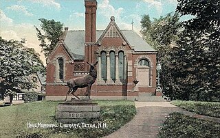
New Hampton is a town in Belknap County, New Hampshire, United States. The population was 2,377 at the 2020 census. A winter sports resort area, New Hampton is home to George Duncan State Forest and to the New Hampton School, a private preparatory school established in 1821.

<span class="mw-page-title-main">Tilton, New Hampshire</span> Town in New Hampshire, United States

Tilton is a town on the Winnipesaukee River in Belknap County, New Hampshire, United States. The population was 3,962 at the 2020 census, up from 3,567 at the 2010 census. It includes the villages of Tilton and Lochmere and part of the village of Winnisquam. Tilton is home to the Tilton School, a private preparatory school.

<span class="mw-page-title-main">Ashland, New Hampshire</span> Town in New Hampshire, United States

Ashland is a town in Grafton County, New Hampshire, United States. The population was 1,938 at the 2020 census, down from 2,076 at the 2010 census. Located near the geographical center of the state, Ashland is home to Scribner-Fellows State Forest.

<span class="mw-page-title-main">Campton, New Hampshire</span> Town in New Hampshire, United States

Campton is a town in Grafton County, New Hampshire, United States. The population was 3,343 at the 2020 census. Campton, which includes the villages of Blair, Campton Hollow, Lower Campton and West Campton, is home to Blair State Forest and Livermore Falls State Forest. It is located in the foothills of the White Mountains, and parts of the White Mountain National Forest are in the northeast and northwest.

<span class="mw-page-title-main">Ellsworth, New Hampshire</span> Town in New Hampshire, United States

Ellsworth is a town in Grafton County, New Hampshire, United States. The population was 93 at the 2020 census.

<span class="mw-page-title-main">Rumney, New Hampshire</span> Town in New Hampshire, United States

Rumney is a town in Grafton County, New Hampshire, United States. The population was 1,498 at the 2020 census. The town is located at the southern edge of the White Mountain National Forest.

<span class="mw-page-title-main">Woodstock, New Hampshire</span> Town in New Hampshire, United States

Woodstock is a town in Grafton County, New Hampshire, United States. The population was 1,434 at the 2020 census. Woodstock includes the village of North Woodstock, the commercial center. Its extensive land area is largely forested, and includes the Hubbard Brook Experimental Forest. Parts of the White Mountain National Forest are in the east and west. The Appalachian Trail crosses the town's northwest corner. Russell Pond Campground is in the east. West of North Woodstock is the Lost River Reservation.

<span class="mw-page-title-main">Epsom, New Hampshire</span> Town in New Hampshire, United States

Epsom is a town in Merrimack County, New Hampshire, United States. The population was 4,834 at the 2020 census.

<span class="mw-page-title-main">Franklin, New Hampshire</span> City in New Hampshire, United States

Franklin is a city in Merrimack County, New Hampshire, United States. At the 2020 census, the population was 8,741, the least of New Hampshire's 13 cities. Franklin includes the village of West Franklin.

<span class="mw-page-title-main">Hill, New Hampshire</span> Town in New Hampshire, United States

Hill is a town in Merrimack County, New Hampshire, United States. The population was 1,017 at the 2020 census. It is home to William Thomas State Forest.

<span class="mw-page-title-main">Northfield, New Hampshire</span> Town in New Hampshire, United States

Northfield is a town in Merrimack County, New Hampshire, United States. The population was 4,872 at the 2020 census.

<span class="mw-page-title-main">Meredith, New Hampshire</span> Town in New Hampshire, United States

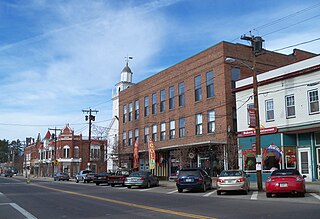
Meredith is a town in Belknap County, New Hampshire, United States. The population was 6,662 at the 2020 census. Meredith is situated in the state's Lakes Region and serves as a major resort town. Meredith Village, the commercial center of the town, lies long the shores of Lake Winnipesaukee, and several other large lakes lie partially or completely within the town borders. It is home to the Stonedam Island Natural Area and the Winnipesaukee Scenic Railroad, and it serves as one of the ports of call for the MS Mount Washington.

<span class="mw-page-title-main">Bristol (CDP), New Hampshire</span> Census-designated place in New Hampshire, United States

Bristol is a census-designated place (CDP) and the main village in the town of Bristol in Grafton County, New Hampshire, United States. The population of the CDP was 1,911 at the 2020 census, out of 3,244 in the entire town.

<span class="mw-page-title-main">Plymouth (CDP), New Hampshire</span> Census-designated place in New Hampshire, United States

Plymouth is a census-designated place (CDP) and the main village in the town of Plymouth in Grafton County, New Hampshire, United States. Its population was 4,730 at the 2020 census, out of 6,682 in the entire town. The CDP includes the campus of Plymouth State University.

<span class="mw-page-title-main">North Woodstock, New Hampshire</span> Census-designated place in New Hampshire, United States

North Woodstock is a census-designated place (CDP) and the primary village in the town of Woodstock in Grafton County, New Hampshire, United States. It had a population of 739 at the 2020 census.

New Hampton is a census-designated place (CDP) and the main village in the town of New Hampton in Belknap County, New Hampshire, United States. The population was 373 at the 2020 census, out of 2,377 people in the entire town of New Hampton.

Lincoln is a census-designated place (CDP) and the main village in the town of Lincoln in Grafton County, New Hampshire, United States. The population of the CDP was 969 at the 2020 census, out of 1,631 in the entire town.

References

Bay Meeting House c. 1910 Bay Meeting House, Sanbornton, NH.jpg
Bay Meeting House c.1910
  1. 1 2 "2020 U.S. Gazetteer Files – New Hampshire". United States Census Bureau. Retrieved October 28, 2021.
  2. 1 2 3 "Sanbornton town, Belknap County, New Hampshire: 2020 DEC Redistricting Data (PL 94-171)". U.S. Census Bureau. Retrieved October 28, 2021.
  3. Coolidge, Austin J.; John B. Mansfield (1859). A History and Description of New England. Boston, Massachusetts: A.J. Coolidge. pp.  643–644. coolidge mansfield history description new england 1859.
  4. History of Sanbornton, New Hampshire, Moses Thurston Runnels, 1881
  5. Atlas of Historical County Boundaries. The Newberry Library Dr. William M. Scholl Center for American History and Culture. Accessed July 19, 2023.
  6. "Census of Population and Housing". Census.gov. Retrieved June 4, 2016.
  7. "U.S. Census website". United States Census Bureau . Retrieved January 31, 2008.
  8. Runnels, M. T. History of Sanbornton, New Hampshire. Vol. 1. Boston: Alfred Mudge & Son, 1882.
  9. Willard, Frances Elizabeth; Livermore, Mary Ashton Rice (1893). "COLBY, Miss Sarah A.". A Woman of the Century: Fourteen Hundred-seventy Biographical Sketches Accompanied by Portraits of Leading American Women in All Walks of Life (Public domain ed.). Charles Wells Moulton. pp. 190–191.
  10. "HARPER, Joseph Morrill, (1787 - 1865)". Biographical Directory of the United States Congress. Retrieved December 13, 2013.
  11. "Don Kent, 92; WBZ-TV weatherman whose gimmick was credibility". Boston.Com. Retrieved December 13, 2013.
  12. "Profile for Sanbornton, New Hampshire, NH". ePodunk. Retrieved December 13, 2013.
  13. "Daniel Sanborn Miles – Biography". josephsmithpapers.org. Retrieved February 3, 2019.
  14. "Biographical Sketches". Wisconsin Blue Book. 1879. Retrieved February 1, 2014.

Further reading