Belmont (CDP), New Hampshire

Last updated

Belmont, New Hampshire
Belmont NH CDP Sept 2019.jpg
Main Street in Belmont
USA New Hampshire location map.svg
Red pog.svg
Belmont
Usa edcp location map.svg
Red pog.svg
Belmont
Coordinates: 43°26′34″N71°28′55″W / 43.44278°N 71.48194°W / 43.44278; -71.48194
Country United States
State New Hampshire
County Belknap
Town Belmont
Area
[1]
  Total1.27 sq mi (3.30 km2)
  Land1.26 sq mi (3.26 km2)
  Water0.01 sq mi (0.04 km2)
Elevation
528 ft (161 m)
Population
 (2020)
  Total1,285
  Density1,021.46/sq mi (394.45/km2)
Time zone UTC-5 (Eastern (EST))
  Summer (DST) UTC-4 (EDT)
ZIP code
03220
Area code 603
FIPS code 33-04660
GNIS feature ID2629713

Belmont is a census-designated place (CDP) and the main village in the town of Belmont in Belknap County, New Hampshire, United States. The population was 1,285 at the 2020 census, [2] out of 7,314 in the entire town of Belmont.

Contents

Geography

The CDP is in the southern part of the town, along a portion of the Tioga River that drops about 40 feet (12 m) in 0.4 miles (0.64 km). The CDP extends southwest to Pumping Station Brook, south as far as Wareing Road and Higgins Drive, east to include Belmont Elementary School and the housing development around Sleepy Hollow Lane, north to Perkins Road, River Street, Seavey Road, and Hurricane Road, and northwest to an unnamed brook that joins the Tioga River just west of Pumping Station Brook. [3]

New Hampshire Routes 106 and 140 intersect in the CDP just east of the village center. Route 106 leads north 6 miles (10 km) to Laconia and south 16 miles (26 km) to Interstate 393 in the east part of Concord, while Route 140 leads east 16 miles (26 km) to Alton and west 5 miles (8 km) to U.S. Route 3 in Tilton.

According to the United States Census Bureau, the Belmont CDP has a total area of 1.3 square miles (3.3 km2), of which 0.02 square miles (0.04 km2), or 1.15%, are water. [4]

Demographics

Historical population
CensusPop.Note
2010 1,301
2020 1,285−1.2%
U.S. Decennial Census [5]

As of the census of 2010, there were 1,301 people, 515 households, and 356 families residing in the CDP. There were 570 housing units, of which 55, or 9.6%, were vacant. The racial makeup of the CDP was 96.1% white, 0.6% African American, 0.1% Native American, 0.5% Asian, 0.0% Pacific Islander, 0.2% some other race, and 2.5% from two or more races. 1.5% of the population were Hispanic or Latino of any race. [6]

Of the 515 households in the CDP, 39.2% had children under the age of 18 living with them, 42.9% were headed by married couples living together, 16.1% had a female householder with no husband present, and 30.9% were non-families. 26.2% of all households were made up of individuals, and 10.1% were someone living alone who was 65 years of age or older. The average household size was 2.53, and the average family size was 2.90. [6]

26.7% of residents in the CDP were under the age of 18, 7.9% were from age 18 to 24, 25.2% were from 25 to 44, 26.6% were from 45 to 64, and 13.6% were 65 years of age or older. The median age was 36.1 years. For every 100 females, there were 94.5 males. For every 100 females age 18 and over, there were 91.0 males. [6]

For the period 2011-15, the estimated median annual income for a household was $60,625, and the median income for a family was $66,328. The per capita income for the CDP was $21,038. [7]

Related Research Articles

<span class="mw-page-title-main">Belmont, New Hampshire</span> Town in New Hampshire, United States

Belmont is a town in Belknap County, New Hampshire, United States. The population was 7,314 at the 2020 census.

<span class="mw-page-title-main">Marlborough (CDP), New Hampshire</span> Census-designated place in New Hampshire, United States

Marlborough is a census-designated place (CDP) and the main village in the town of Marlborough in Cheshire County, New Hampshire, United States. The population of the CDP was 1,066 at the 2020 census, out of 2,096 in the entire town.

<span class="mw-page-title-main">Winchester (CDP), New Hampshire</span> Census-designated place in New Hampshire, United States

Winchester is a census-designated place (CDP) and the main village in the town of Winchester in Cheshire County, New Hampshire, United States. The population of the CDP was 1,606 at the 2020 census, compared to 4,150 in the entire town.

Whitefield is a census-designated place (CDP) and the main village in the town of Whitefield in Coos County, New Hampshire, United States. The population of the CDP was 1,460 at the 2020 census, out of 2,490 people in the entire town of Whitefield.

Hanover is a census-designated place (CDP) and the main village in the town of Hanover in Grafton County, New Hampshire, United States. The population of the CDP was 9,078 at the 2020 census, out of 11,870 in the entire town. The CDP includes the campus of Dartmouth College.

Littleton is a census-designated place (CDP) and the main village in the town of Littleton in Grafton County, New Hampshire, United States. The population of the CDP was 4,467 at the 2020 census, out of 6,005 in the entire town.

<span class="mw-page-title-main">Plymouth (CDP), New Hampshire</span> Census-designated place in New Hampshire, United States

Plymouth is a census-designated place (CDP) and the main village in the town of Plymouth in Grafton County, New Hampshire, United States. Its population was 4,730 at the 2020 census, out of 6,682 in the entire town. The CDP includes the campus of Plymouth State University.

<span class="mw-page-title-main">Antrim (CDP), New Hampshire</span> Census-designated place in New Hampshire, United States

Antrim is a census-designated place (CDP) and the main village in the town of Antrim in Hillsborough County, New Hampshire, United States. The population of the CDP was 1,395 at the 2020 census, out of 2,651 in the entire town.

<span class="mw-page-title-main">Wilton (CDP), New Hampshire</span> Census-designated place in New Hampshire, United States

Wilton is a census-designated place (CDP) and the main village in the town of Wilton, Hillsborough County, New Hampshire, United States. The CDP extends east into the town of Milford as well. The population of the CDP was 1,324 at the 2020 census, up from 1,163 at the 2010 census.

<span class="mw-page-title-main">Exeter (CDP), New Hampshire</span> Census-designated place in New Hampshire, United States

Exeter is a census-designated place (CDP) and the main village in the town of Exeter, Rockingham County, New Hampshire, United States. The population of the CDP was 10,109 at the 2020 census, out of 16,049 in the entire town.

<span class="mw-page-title-main">Hampton (CDP), New Hampshire</span> Census-designated place in New Hampshire, United States

Hampton is a census-designated place (CDP) comprising the town center and surrounding developed areas of the town of Hampton, Rockingham County, New Hampshire, United States. The population of the CDP was 9,597 at the 2020 census, out of 16,214 in the entire town.

<span class="mw-page-title-main">Londonderry (CDP), New Hampshire</span> Census-designated place in New Hampshire, United States

Londonderry is a census-designated place (CDP) within the town of Londonderry in Rockingham County, New Hampshire, United States. The population of the CDP was 11,645 at the 2020 census, out of 25,826 in the entire town.

<span class="mw-page-title-main">Raymond (CDP), New Hampshire</span> Census-designated place in New Hampshire, United States

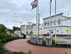
Raymond is a census-designated place (CDP) and the main village in the town of Raymond, Rockingham County, New Hampshire, United States. The population of the CDP was 3,738 at the 2020 census, out of 10,684 in the entire town.

<span class="mw-page-title-main">Durham (CDP), New Hampshire</span> Census-designated place in New Hampshire, United States

Durham is a census-designated place (CDP) and the main village in the town of Durham in Strafford County, New Hampshire, United States. The population of the CDP was 11,147 at the 2020 census, out of 15,490 in the entire town. The CDP is home to the University of New Hampshire.

<span class="mw-page-title-main">Charlestown (CDP), New Hampshire</span> Census-designated place in New Hampshire, United States

Charlestown is a census-designated place (CDP) and the main village in the town of Charlestown, Sullivan County, New Hampshire, United States. The population of the CDP was 1,078 at the 2020 census, out of 4,806 in the entire town.

<span class="mw-page-title-main">Newport (CDP), New Hampshire</span> Census-designated place in New Hampshire, United States

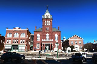
Newport is a census-designated place (CDP) comprising the main village and surrounding rural land in the town of Newport, Sullivan County, New Hampshire, United States. The population of the CDP was 4,735 at the 2020 census, out of 6,299 in the entire town.

<span class="mw-page-title-main">Newfields (CDP), New Hampshire</span> Census-designated place in New Hampshire, United States

Newfields is a census-designated place (CDP) and the main village within the town of Newfields, Rockingham County, New Hampshire, United States. The population of the CDP was 378 at the 2020 census, out of 1,769 in the entire town.

<span class="mw-page-title-main">Bennington (CDP), New Hampshire</span> Census-designated place in New Hampshire, United States

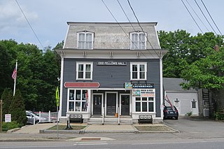
Bennington is a census-designated place (CDP) and the main village in the town of Bennington in Hillsborough County, New Hampshire, United States. The population of the CDP was 338 at the 2020 census, out of 1,501 in the entire town.

<span class="mw-page-title-main">Hancock (CDP), New Hampshire</span> Census-designated place in New Hampshire, United States

Hancock is a census-designated place (CDP) and the main village in the town of Hancock in Hillsborough County, New Hampshire, United States. The population of the CDP was 213 at the 2020 census, out of 1,731 in the entire town.

<span class="mw-page-title-main">Walpole (CDP), New Hampshire</span> Census-designated place in New Hampshire, United States

Walpole is a census-designated place (CDP) and the central village in the town of Walpole in Cheshire County, New Hampshire, United States. The population of the CDP was 573 at the 2020 census, compared to 3,633 in the entire town.

References

  1. "ArcGIS REST Services Directory". United States Census Bureau. Retrieved September 20, 2022.
  2. "Belmont CDP, New Hampshire: 2020 DEC Redistricting Data (PL 94-171)". U.S. Census Bureau. Retrieved October 28, 2021.
  3. "TIGERweb: Belmont CDP, New Hampshire". Geography Division, U.S. Census Bureau. Retrieved August 25, 2017.
  4. "2020 U.S. Gazetteer Files – New Hampshire". United States Census Bureau. Retrieved October 28, 2021.
  5. "Decennial Census Official Publications". Census.gov. Retrieved March 4, 2024.
  6. 1 2 3 "Profile of General Population and Housing Characteristics: 2010 Census Summary File 1 (DP-1): Belmont CDP, New Hampshire". American Factfinder. U.S. Census Bureau. Archived from the original on February 13, 2020. Retrieved October 11, 2017.
  7. "Selected Economic Characteristics: 2011-2015 American Community Survey 5-Year Estimates (DP03): Belmont CDP, New Hampshire". American Factfinder. U.S. Census Bureau. Archived from the original on February 13, 2020. Retrieved October 11, 2017.