New Hampton (CDP), New Hampshire

Last updated

New Hampton, New Hampshire
USA New Hampshire location map.svg
Red pog.svg
New Hampton
Usa edcp location map.svg
Red pog.svg
New Hampton
Coordinates: 43°39′20″N71°39′8″W / 43.65556°N 71.65222°W / 43.65556; -71.65222
Country United States
State New Hampshire
County Belknap
Town New Hampton
Area
[1]
  Total1.37 sq mi (3.54 km2)
  Land1.27 sq mi (3.29 km2)
  Water0.10 sq mi (0.25 km2)
Elevation
525 ft (160 m)
Population
 (2020)
  Total373
  Density293.24/sq mi (113.26/km2)
Time zone UTC-5 (Eastern (EST))
  Summer (DST) UTC-4 (EDT)
ZIP code
03256
Area code 603
FIPS code 33-51460
GNIS feature ID2629732

New Hampton is a census-designated place (CDP) and the main village in the town of New Hampton in Belknap County, New Hampshire, United States. The population was 373 at the 2020 census, [2] out of 2,377 people in the entire town of New Hampton.

Contents

Geography

The CDP is near the geographic center of the town of New Hampton, and is bordered to the north by the Pemigewasset River and to the east by Interstate 93. To the south the CDP border follows unnamed brooks through the New Hampton Fish Hatchery, running south (upstream) to Gordon Hill Road, then turns north down another unnamed brook to the main (unnamed) stream through the village, following it downstream to the Pemigewasset. [3] The CDP includes the campus of New Hampton School, a private college preparatory high school.

Interstate 93 crosses New Hampshire Route 104 at Exit 23 on the eastern edge of the CDP. I-93 leads north 11 miles (18 km) to Plymouth and south 31 miles (50 km) to Concord, the state capital. NH 104 leads east 9 miles (14 km) to Meredith and west 5 miles (8 km) to Bristol. New Hampshire Route 132 turns south from NH 104 on the western side of the CDP and proceeds east through the village center, then continues south through Sanbornton 12 miles (19 km) to U.S. Route 3 in Tilton.

According to the United States Census Bureau, the New Hampton CDP has a total area of 1.37 square miles (3.54 km2), of which 1.27 square miles (3.29 km2) are land and 0.10 square miles (0.25 km2), or 7.10%, are water. [4]

Demographics

Historical population
CensusPop.Note
2010 351
2020 3736.3%
U.S. Decennial Census [5]

As of the census of 2010, there were 351 people, 119 households, and 85 families residing in the CDP. There were 128 housing units, of which 9, or 7.0%, were vacant. The racial makeup of the CDP was 98.3% white, 0.3% Native American, 1.1% Asian, and 0.3% from two or more races. 2.0% of the population were Hispanic or Latino of any race. [6]

Of the 119 households in the CDP, 39.5% had children under the age of 18 living with them, 54.6% were headed by married couples living together, 12.6% had a female householder with no husband present, and 28.6% were non-families. 24.4% of all households were made up of individuals, and 11.8% were someone living alone who was 65 years of age or older. The average household size was 2.48, and the average family size was 2.94. [6]

29.3% of residents in the CDP were under the age of 18, 4.2% were from age 18 to 24, 31.4% were from 25 to 44, 24.5% were from 45 to 64, and 10.5% were 65 years of age or older. The median age was 35.6 years. For every 100 females, there were 99.4 males. For every 100 females age 18 and over, there were 92.2 males. [6]

For the period 2011-15, the estimated median annual income for a household was $89,632, and the median income for a family was $88,971. The per capita income for the CDP was $33,602. [7]

Related Research Articles

<span class="mw-page-title-main">New Hampton, New Hampshire</span> Town in New Hampshire, United States

New Hampton is a town in Belknap County, New Hampshire, United States. The population was 2,377 at the 2020 census. A winter sports resort area, New Hampton is home to George Duncan State Forest and to the New Hampton School, a private preparatory school established in 1821.

<span class="mw-page-title-main">Sanbornton, New Hampshire</span> Town in New Hampshire, United States

Sanbornton is a town in Belknap County, New Hampshire, United States. The population was 3,026 at the 2020 census. It includes the villages of North Sanbornton and Gaza.

<span class="mw-page-title-main">Contoocook, New Hampshire</span> Census-designated place in New Hampshire, United States

Contoocook is a village and census-designated place (CDP) within the town of Hopkinton in Merrimack County, New Hampshire, United States. The population was 1,427 at the 2020 census. Contoocook is well known for its growth of small businesses, preservation of historical landmarks, community involvement and recreational activities within the village.

<span class="mw-page-title-main">Franklin, New Hampshire</span> City in New Hampshire, United States

Franklin is a city in Merrimack County, New Hampshire, United States. At the 2020 census, the population was 8,741, the least of New Hampshire's 13 cities. Franklin includes the village of West Franklin.

<span class="mw-page-title-main">Meredith (CDP), New Hampshire</span> Census-designated place in New Hampshire, United States

Meredith is a census-designated place (CDP) and the main village in the town of Meredith in Belknap County, New Hampshire, United States. The population was 2,527 at the 2020 census, out of 6,662 in the entire town of Meredith.

<span class="mw-page-title-main">Wolfeboro (CDP), New Hampshire</span> Census-designated place in New Hampshire, United States

Wolfeboro is a census-designated place (CDP) in the town of Wolfeboro in Carroll County, New Hampshire, United States. It consists of the main village of Wolfeboro within the town, as well as the smaller village of Wolfeboro Falls. The population of the CDP was 3,300 at the 2020 census, out of 6,416 in the entire town of Wolfeboro.

<span class="mw-page-title-main">Bristol (CDP), New Hampshire</span> Census-designated place in New Hampshire, United States

Bristol is a census-designated place (CDP) and the main village in the town of Bristol in Grafton County, New Hampshire, United States. The population of the CDP was 1,911 at the 2020 census, out of 3,244 in the entire town.

<span class="mw-page-title-main">Plymouth (CDP), New Hampshire</span> Census-designated place in New Hampshire, United States

Plymouth is a census-designated place (CDP) and the main village in the town of Plymouth in Grafton County, New Hampshire, United States. Its population was 4,730 at the 2020 census, out of 6,682 in the entire town. The CDP includes the campus of Plymouth State University.

<span class="mw-page-title-main">Plymouth, New Hampshire</span> Town in New Hampshire, United States

Plymouth is a rural town in Grafton County, New Hampshire, United States, in the White Mountains Region. It has a unique role as the economic, medical, commercial, and cultural center for the predominantly rural Plymouth, NH Labor Market Area. Plymouth is located at the confluence of the Pemigewasset and Baker rivers and sits at the foot of the White Mountains. The town's population was 6,682 at the 2020 census. It is home to Plymouth State University, Speare Memorial Hospital, and Plymouth Regional High School.

<span class="mw-page-title-main">Hooksett (CDP), New Hampshire</span> Census-designated place in New Hampshire, United States

Hooksett is a census-designated place (CDP) in the town of Hooksett in Merrimack County, New Hampshire, United States. The CDP includes the historic central village of Hooksett as well as suburban and rural land surrounding it. The population of the CDP was 5,283 at the 2020 census, out of 14,871 in the entire town.

<span class="mw-page-title-main">Epping (CDP), New Hampshire</span> Census-designated place in New Hampshire, United States

Epping is a census-designated place (CDP) and the main village in the town of Epping, Rockingham County, New Hampshire, United States. The population of the CDP was 2,693 at the 2020 census, out of 7,125 in the entire town.

<span class="mw-page-title-main">Exeter (CDP), New Hampshire</span> Census-designated place in New Hampshire, United States

Exeter is a census-designated place (CDP) and the main village in the town of Exeter, Rockingham County, New Hampshire, United States. The population of the CDP was 10,109 at the 2020 census, out of 16,049 in the entire town.

<span class="mw-page-title-main">Hampton (CDP), New Hampshire</span> Census-designated place in New Hampshire, United States

Hampton is a census-designated place (CDP) comprising the town center and surrounding developed areas of the town of Hampton, Rockingham County, New Hampshire, United States. The population of the CDP was 9,597 at the 2020 census, out of 16,214 in the entire town.

<span class="mw-page-title-main">Hampton Beach, New Hampshire</span> Census-designated place in New Hampshire, United States

Hampton Beach is a village district, census-designated place, and beach resort in the town of Hampton, New Hampshire, United States, along the Atlantic Ocean. Its population at the 2020 census was 2,598. Hampton Beach is in Rockingham County, about 15 miles (24 km) south of Portsmouth. The community is a popular tourist destination and the busiest beach community in New Hampshire. Ocean Boulevard, the main street along the beach, includes a boardwalk, many shops and businesses, several seasonal hotels, and the Hampton Beach Casino Ballroom, which hosts national acts in the summer. Hampton Beach State Park was named one of four "Superstar" beaches in the United States in 2011, for having had perfect water-quality testing results in each of the previous three years.

<span class="mw-page-title-main">North Woodstock, New Hampshire</span> Census-designated place in New Hampshire, United States

North Woodstock is a census-designated place (CDP) and the primary village in the town of Woodstock in Grafton County, New Hampshire, United States. It had a population of 739 at the 2020 census.

<span class="mw-page-title-main">Seabrook Beach, New Hampshire</span> Census-designated place in New Hampshire, United States

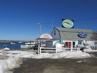
Seabrook Beach is a census-designated place in the town of Seabrook and partially in the town of Hampton in Rockingham County, New Hampshire, United States. It had a population of 1,078 at the 2020 census.

<span class="mw-page-title-main">Ashland (CDP), New Hampshire</span> Census-designated place in New Hampshire, United States

Ashland is a census-designated place (CDP) and the main village in the town of Ashland in Grafton County, New Hampshire, United States. The population of the CDP was 1,082 at the 2020 census, out of 1,938 in the entire town.

<span class="mw-page-title-main">Bennington (CDP), New Hampshire</span> Census-designated place in New Hampshire, United States

Bennington is a census-designated place (CDP) and the main village in the town of Bennington in Hillsborough County, New Hampshire, United States. The population of the CDP was 338 at the 2020 census, out of 1,501 in the entire town.

Lincoln is a census-designated place (CDP) and the main village in the town of Lincoln in Grafton County, New Hampshire, United States. The population of the CDP was 969 at the 2020 census, out of 1,631 in the entire town.

<span class="mw-page-title-main">Walpole (CDP), New Hampshire</span> Census-designated place in New Hampshire, United States

Walpole is a census-designated place (CDP) and the central village in the town of Walpole in Cheshire County, New Hampshire, United States. The population of the CDP was 573 at the 2020 census, compared to 3,633 in the entire town.

References

  1. "ArcGIS REST Services Directory". United States Census Bureau. Retrieved September 20, 2022.
  2. "New Hampton CDP, New Hampshire: 2020 DEC Redistricting Data (PL 94-171)". U.S. Census Bureau. Retrieved October 28, 2021.
  3. "TIGERweb: New Hampton CDP, New Hampshire". Geography Division, U.S. Census Bureau. Retrieved August 25, 2017.
  4. "2020 U.S. Gazetteer Files – New Hampshire". United States Census Bureau. Retrieved October 28, 2021.
  5. "Decennial Census Official Publications". Census.gov. Retrieved March 4, 2024.
  6. 1 2 3 "Profile of General Population and Housing Characteristics: 2010 Census Summary File 1 (DP-1): New Hampton CDP, New Hampshire". American Factfinder. U.S. Census Bureau. Archived from the original on February 13, 2020. Retrieved October 11, 2017.
  7. "Selected Economic Characteristics: 2011-2015 American Community Survey 5-Year Estimates (DP03): New Hampton CDP, New Hampshire". American Factfinder. U.S. Census Bureau. Archived from the original on February 13, 2020. Retrieved October 11, 2017.