Alton, New Hampshire

Last updated

Alton, New Hampshire
Monument Square Alton.jpg
Monument Square in the center of Alton
Alton, NH Town Seal.png
Belknap-Alton-NH.png
Coordinates: 43°27′15″N71°13′11″W / 43.45417°N 71.21972°W / 43.45417; -71.21972
CountryUnited States
State New Hampshire
County Belknap
Incorporated 1796
Villages
Government
   Board of Selectmen
  • Paul E. LaRochelle, Chair
  • Brock Mitchell
  • Andrew Morse
  • Richard Shea
  • Nicholas Buonopane III
  Town AdministratorRyan Heath
Area
[1]
  Total83.2 sq mi (215.4 km2)
  Land63.7 sq mi (165.0 km2)
  Water19.5 sq mi (50.5 km2)  23.42%
Elevation
560 ft (171 m)
Population
 (2020) [2]
  Total5,894
  Density92/sq mi (35.7/km2)
Time zone UTC−5 (Eastern)
  Summer (DST) UTC−4 (Eastern)
ZIP codes
03809 (Alton)
03810 (Alton Bay)
Area code 603
FIPS code 33-01060
GNIS feature ID0873530
Website www.alton.nh.gov

Alton is a town in Belknap County, New Hampshire, United States. The population was 5,894 at the 2020 census, [2] up from 5,250 at the 2010 census. [3] It is home to Alton Bay State Forest and Mount Major State Forest.

Contents

The primary settlement in town, where 499 people resided at the 2020 census, is defined by the U.S. Census Bureau as the Alton census-designated place (CDP) and is centered on the intersection of New Hampshire Route 11 and New Hampshire Route 140. The town also includes the village of Alton Bay, a long-time resort located beside Lake Winnipesaukee.

History

Originally called "New Durham Gore" [4] because of rocky upland areas, or "gores", the town was settled in 1770, mainly by farmers because the highland areas provided less frost. Merchants then filled the lowlands. Early Alton history recounts stories of the merchants trying to convince the farmers to incorporate. They would succeed on 15 January 1796, [5] when the community was named after Alton, a small market town in Hampshire, England. [6]

Alton was part of Strafford County until Belknap County was erected on 22 December 1840. [7] By 1840, the village of Alton existed at the town's center. In 1847, the Cochecho Railroad began bringing passengers and freight to Alton Village and Alton Bay. By 1859, the town had two gristmills, seven sawmills, and five shoe factories. [6] But the most famous business was the Rockwell Clough Company, established by William Rockwell Clough, inventor of the corkscrew. By 1903, his company was producing 30 million corkscrews worldwide. [8]

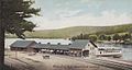
Since the mid-19th century, however, tourism has been the principal business. In 1863, an Adventist group held a camp meeting at Alton Bay, which was the terminus of the Dover and Winnipiseogee Railroad. [5] That was incorporated as the Alton Bay Camp Meeting Association (now known as Alton Bay Christian Conference Center) in 1876. [9] In 1872, the Boston & Maine Railroad launched at Alton Bay the steamer Mount Washington, the first side-wheeler and largest vessel on Lake Winnipesaukee. When destroyed by fire in 1939, a replacement ship was found, also christened Mount Washington. Today, it continues to carry summer tourists between stops on the lake. The railway survived until 1935, and the old station at Alton Bay is now a community center. [10]

Geography

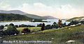
According to the United States Census Bureau, the town has a total area of 83.2 square miles (215.4 km2), of which 63.7 square miles (165.0 km2) are land and 19.5 square miles (50.5 km2) are water, comprising 23.4% of the town. [1] Alton is located at the southern end of Lake Winnipesaukee, around the 4-mile-long (6.4 km) inlet known as Alton Bay. The village of Alton Bay is located at the southern tip of the bay, while the main village of Alton is located 1 mile (1.6 km) farther south. The town is drained by the Merrymeeting River, the main inlet to Alton Bay. Mount Major, in Mount Major State Forest, has an elevation of 1,780 feet (540 m) above sea level. Popular with hikers, the summit offers unsurpassed views of Lake Winnipesaukee. The highest point in Alton is the north peak of Straightback Mountain, at 1,910 ft (580 m), just west of Mount Major. Both mountains are part of the Belknap Mountains range. Alton lies almost fully within the Merrimack River watershed, though a tiny corner is in the Piscataqua River (coastal) watershed. [11]

The town is served by five state highways. New Hampshire Route 11 passes through the center of town, leading northwest along the shore of Lake Winnipesaukee to Gilford and thence to Laconia, and southeast to Rochester. New Hampshire Route 28 also passes through the center of town, leading north to Wolfeboro and south to Pittsfield and Manchester. New Hampshire Route 140 leads from Alton west to Gilmanton and Tilton. New Hampshire Route 11A leaves NH 11 in West Alton and goes west into Gilford, and New Hampshire Route 28A forms an alternate route north from Alton Bay to NH 28.

Adjacent municipalities

Demographics

Historical population
CensusPop.Note
1790 445
1800 72162.0%
1810 1,27977.4%
1820 2,05860.9%
1830 1,993−3.2%
1840 2,0020.5%
1850 1,795−10.3%
1860 2,01812.4%
1870 1,768−12.4%
1880 1,476−16.5%
1890 1,372−7.0%
1900 1,5009.3%
1910 1,348−10.1%
1920 1,221−9.4%
1930 1,2613.3%
1940 1,209−4.1%
1950 1,189−1.7%
1960 1,2414.4%
1970 1,64732.7%
1980 2,44048.1%
1990 3,28634.7%
2000 4,50237.0%
2010 5,25016.6%
2020 5,89412.3%
U.S. Decennial Census [2] [12]

As of the census of 2010, there were 5,250 people, 2,145 households, and 1,511 families residing in the town. There were 4,281 housing units, of which 2,136, or 49.9%, were vacant. 1,928 of the vacant units were for seasonal use. The racial makeup of the town was 98.4% white, 0.1% African American, 0.1% Native American, 0.3% Asian, 0.04% Native Hawaiian or Pacific Islander, 0.2% some other race, and 0.9% from two or more races. 1.1% of the population were Hispanic or Latino of any race. [13]

Of the 2,145 households, 28.4% had children under the age of 18 living with them, 59.0% were headed by married couples living together, 6.9% had a female householder with no husband present, and 29.6% were non-families. 22.7% of all households were made up of individuals, and 9.5% were someone living alone who was 65 years of age or older. The average household size was 2.45, and the average family size was 2.87. [13]

In the town, 21.1% of the population were under the age of 18, 6.2% were from 18 to 24, 20.9% from 25 to 44, 34.9% from 45 to 64, and 16.9% were 65 years of age or older. The median age was 46.2 years. For every 100 females, there were 100.8 males. For every 100 females age 18 and over, there were 99.3 males. [13]

For the period 2011–2015, the estimated median annual income for a household was $66,823, and the median income for a family was $85,556. Male full-time workers had a median income of $46,223 versus $42,448 for females. The per capita income for the town was $29,693. 6.9% of the population and 4.6% of families were below the poverty line. 1.6% of the population under the age of 18 and 9.2% of those 65 or older were living in poverty. [14]

Government

In the New Hampshire Senate, Alton is in the 6th District, represented by Republican James Gray. In the New Hampshire House of Representatives, Alton is in the Belknap 5th district, represented by Republicans Paul Terry and Peter Varney. On the Executive Council of New Hampshire, Alton is in the 1st District, represented by Republican Joseph Kenney. In the United States House of Representatives, Alton is in New Hampshire's 1st congressional district, represented by Democrat Chris Pappas.

Sites of interest

Historic photos

Notable people

Related Research Articles

<span class="mw-page-title-main">Belknap County, New Hampshire</span> County in New Hampshire, United States

Belknap County is a county in the U.S. state of New Hampshire. As of the 2020 census, the population was 63,705. The county seat is Laconia. It is located in New Hampshire's Lakes Region, slightly southeast of the state's geographic center. Belknap County comprises the Laconia, NH Micropolitan Statistical Area, which in turn constitutes a portion of the Boston-Worcester-Providence, MA-RI-NH-CT Combined Statistical Area.

<span class="mw-page-title-main">Barnstead, New Hampshire</span> Town in New Hampshire, United States

Barnstead is a town in Belknap County, New Hampshire, United States. The population was 4,915 at the 2020 census, up from 4,593 at the 2010 census. Home to the Suncook Lakes, Barnstead includes the villages of Center Barnstead, Barnstead Parade and South Barnstead.

<span class="mw-page-title-main">Belmont, New Hampshire</span> Town in New Hampshire, United States

Belmont is a town in Belknap County, New Hampshire, United States. The population was 7,314 at the 2020 census.

<span class="mw-page-title-main">Gilford, New Hampshire</span> Town in New Hampshire, United States

Gilford is a town in Belknap County, New Hampshire, United States. The population was 7,699 at the 2020 census, up from 7,126 at the 2010 census. Situated on Lake Winnipesaukee, Gilford is home to Governors Island, Ellacoya State Beach, Belknap Mountain State Forest, Gunstock Mountain Resort, and the Bank of New Hampshire Pavilion, a seasonal outdoor concert venue. The lakeside village of Glendale lies within Gilford's borders.

<span class="mw-page-title-main">Gilmanton, New Hampshire</span> Town in New Hampshire, United States

Gilmanton is a town in Belknap County, New Hampshire, United States. The population was 3,945 at the 2020 census. Gilmanton includes the villages of Gilmanton Corners and Gilmanton Ironworks. The town became well known in the 1950s after it was rumored that the popular novel Peyton Place, written by resident Grace Metalious, was based on the town.

<span class="mw-page-title-main">Laconia, New Hampshire</span> City in New Hampshire, United States

Laconia is a city in Belknap County, New Hampshire, United States. The population was 16,871 at the 2020 census, up from 15,951 at the 2010 census. It is the county seat of Belknap County. Laconia, situated between Lake Winnipesaukee and Lake Winnisquam, includes the villages of Lakeport and Weirs Beach. Each June, the city hosts Laconia Motorcycle Week, also more simply known as "Bike Week", one of the country's largest rallies.

<span class="mw-page-title-main">New Hampton, New Hampshire</span> Town in New Hampshire, United States

New Hampton is a town in Belknap County, New Hampshire, United States. The population was 2,377 at the 2020 census. A winter sports resort area, New Hampton is home to George Duncan State Forest and to the New Hampton School, a private preparatory school established in 1821.

<span class="mw-page-title-main">Tilton, New Hampshire</span> Town in New Hampshire, United States

Tilton is a town on the Winnipesaukee River in Belknap County, New Hampshire, United States. The population was 3,962 at the 2020 census, up from 3,567 at the 2010 census. It includes the villages of Tilton and Lochmere and part of the village of Winnisquam. Tilton is home to the Tilton School, a private preparatory school.

<span class="mw-page-title-main">Moultonborough, New Hampshire</span> Town in New Hampshire, United States

Moultonborough is a town in Carroll County, New Hampshire, United States. The population was 4,918 at the 2020 census, up from 4,044 at the 2010 census. Moultonborough is bounded in large part by Lake Winnipesaukee in the southwest and to a lesser extent by Squam Lake in the northwestern corner. The town includes the census-designated place of Suissevale and the community of Lees Mill.

<span class="mw-page-title-main">Tuftonboro, New Hampshire</span> Town in New Hampshire, United States

Tuftonboro is a town in Carroll County, New Hampshire, United States. The population was 2,467 at the 2020 census. Bounded on the southwest by Lake Winnipesaukee, Tuftonboro includes the villages of Tuftonboro Corner, Center Tuftonboro, Melvin Village and Mirror Lake.

<span class="mw-page-title-main">Northfield, New Hampshire</span> Town in New Hampshire, United States

Northfield is a town in Merrimack County, New Hampshire, United States. The population was 4,872 at the 2020 census.

<span class="mw-page-title-main">New Durham, New Hampshire</span> Town in New Hampshire, United States

New Durham is a town in Strafford County, New Hampshire, United States. The population was 2,693 at the 2020 census. It is drained by the Merrymeeting, Cocheco and Ela rivers, and is known for Merrymeeting Lake. New Durham is home to the Powder Mill Fish Hatchery, located on Merrymeeting Road. Also located here is the Lions Club's Camp Pride, a camp for children and adults with special needs.

<span class="mw-page-title-main">Tilton Northfield, New Hampshire</span> Census-designated place in New Hampshire, United States

Tilton Northfield is a census-designated place (CDP) representing two adjacent villages in the towns of Tilton in Belknap County and Northfield in Merrimack County in the U.S. state of New Hampshire. The CDP encompasses the town centers of both Tilton and Northfield, located on either side of the Winnipesaukee River. The population was 3,324 at the 2020 census.

<span class="mw-page-title-main">Meredith (CDP), New Hampshire</span> Census-designated place in New Hampshire, United States

Meredith is a census-designated place (CDP) and the main village in the town of Meredith in Belknap County, New Hampshire, United States. The population was 2,527 at the 2020 census, out of 6,662 in the entire town of Meredith.

<span class="mw-page-title-main">Meredith, New Hampshire</span> Town in New Hampshire, United States

Meredith is a town in Belknap County, New Hampshire, United States. The population was 6,662 at the 2020 census. Meredith is situated in the state's Lakes Region and serves as a major resort town. Meredith Village, the commercial center of the town, lies long the shores of Lake Winnipesaukee, and several other large lakes lie partially or completely within the town borders. It is home to the Stonedam Island Natural Area and the Winnipesaukee Scenic Railroad, and it serves as one of the ports of call for the MS Mount Washington.

<span class="mw-page-title-main">Wolfeboro (CDP), New Hampshire</span> Census-designated place in New Hampshire, United States

Wolfeboro is a census-designated place (CDP) in the town of Wolfeboro in Carroll County, New Hampshire, United States. It consists of the main village of Wolfeboro within the town, as well as the smaller village of Wolfeboro Falls. The population of the CDP was 3,300 at the 2020 census, out of 6,416 in the entire town of Wolfeboro.

<span class="mw-page-title-main">Wolfeboro, New Hampshire</span> Town in New Hampshire, United States

Wolfeboro is a town in Carroll County, New Hampshire, United States. The population was 6,416 at the 2020 census. A resort area situated beside Lake Winnipesaukee, Wolfeboro includes the village of Wolfeboro Falls.

<span class="mw-page-title-main">New Hampshire Route 11</span> State highway in central New Hampshire, US

New Hampshire Route 11 is a 108.223-mile-long (174.168 km) east–west state highway in New Hampshire, running completely across the central part of the state. Its western terminus is at the Vermont state line in Charlestown, where it continues west as Vermont Route 11. The eastern terminus is at the Maine state line in Rochester, where it crosses the border with U.S. Route 202 and continues as Maine State Route 11.

Alton is a census-designated place (CDP) and the main village in the town of Alton in Belknap County, New Hampshire, United States. The population was 499 at the 2020 census, compared to 5,894 in the entire town of Alton.

<span class="mw-page-title-main">Belknap Mountains</span> Mountain range in the American state of New Hampshire

The Belknap Mountains are a small mountain range in the Lakes Region of New Hampshire in the United States. The range lies in the towns of Gilford, Gilmanton, and Alton in Belknap County. The highest peak, Belknap Mountain, with an elevation of 2,382 feet (726 m) above sea level, is the highest point in Belknap County. Belknap Mountain State Forest covers the central part of the range, including the summit and slopes of Belknap Mountain.

References

  1. 1 2 "2020 U.S. Gazetteer Files – New Hampshire". United States Census Bureau. Retrieved October 28, 2021.
  2. 1 2 3 "Alton town, Belknap County, New Hampshire: 2020 DEC Redistricting Data (PL 94-171)". U.S. Census Bureau. Retrieved October 28, 2021.
  3. "Geographic Identifiers: 2010 Demographic Profile Data (G001): Alton town, Belknap County, New Hampshire". U.S. Census Bureau, American Factfinder. Archived from the original on February 12, 2020. Retrieved December 13, 2013.
  4. Hayward's New England Gazetteer (1839)
  5. 1 2 Statistics and Gazetteer of New-Hampshire (1875)
  6. 1 2 Coolidge, Austin J.; John B. Mansfield (1859). A History and Description of New England. Boston, Massachusetts: A.J. Coolidge. p.  409. coolidge mansfield history description new england 1859.
  7. Statistics and Gazetteer of New-Hampshire (1875)
  8. A. Chester Clark, "The Rockwell Clough Company;" The Granite State Monthly, Volume 41, 1909
  9. "History of Alton Bay Christian Conference Center in NH". altonbay.org. Retrieved March 29, 2018.
  10. The MS Mount Washington, a History -- Lake Winnipesaukee Historical Society
  11. Foster, Debra H.; Batorfalvy, Tatianna N.; Medalie, Laura (1995). Water Use in New Hampshire: An Activities Guide for Teachers. U.S. Department of the Interior and U.S. Geological Survey.
  12. "Census of Population and Housing". Census.gov. Retrieved June 4, 2016.
  13. 1 2 3 "Profile of General Population and Housing Characteristics: 2010 Census Summary File 1 (DP-1): Alton town, Belknap County, New Hampshire". U.S. Census Bureau, American Factfinder. Archived from the original on February 14, 2020. Retrieved October 24, 2017.
  14. "Selected Economic Characteristics: 2011-2015 American Community Survey 5-Year Estimates (DP03): Alton town, Belknap County, New Hampshire". U.S. Census Bureau, American Factfinder. Archived from the original on February 13, 2020. Retrieved October 24, 2017.
  15. Alton Historical Society
  16. Welcome to Alton, New Hampshire - Museum Archived 2015-01-12 at the Wayback Machine
  17. "Stephen Leach Stats and News". NHL.com. Retrieved October 5, 2017.
  18. "Don Sweeney hockey statistics and profile at hockeydb.com". www.hockeydb.com. Retrieved October 5, 2017.