New Durham, New Hampshire

Last updated

New Durham, New Hampshire
Town
Church, New Durham, NH.jpg
New Durham, NH Town Seal.png
Strafford-New-Durham-NH.png
Location in Strafford County, New Hampshire
Coordinates: 43°26′05″N71°09′50″W / 43.43472°N 71.16389°W / 43.43472; -71.16389
Country United States
State New Hampshire
County Strafford
Incorporated 1762
Villages
  • New Durham
  • New Durham Corner
Government
   Select Board
  • David "Swens" Swenson, Chair
  • Dot Veisel
  • Marc DeCoff
  Town AdministratorNicole Zoltko
Area
[1]
  Total43.8 sq mi (113.5 km2)
  Land41.2 sq mi (106.7 km2)
  Water2.6 sq mi (6.8 km2)  5.98%
Elevation
544 ft (166 m)
Population
 (2020)
  Total2,693
  Density65/sq mi (25.2/km2)
Time zone UTC-5 (Eastern)
  Summer (DST) UTC-4 (Eastern)
ZIP code
03855
Area code 603
FIPS code 33-51220
GNIS feature ID0873677
Website www.newdurhamnh.us

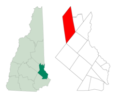
New Durham is a town in Strafford County, New Hampshire, United States. The population was 2,693 at the 2020 census. [2] It is drained by the Merrymeeting, Cocheco and Ela rivers, and is known for Merrymeeting Lake. New Durham is home to the Powder Mill Fish Hatchery, located on Merrymeeting Road. Also located here is the Lions Club's Camp Pride, a camp for children and adults with special needs.

Contents

History

Granted by the Masonian Proprietors in 1749 as "Cochecho Township", New Durham was first settled by Europeans in 1750, almost entirely by colonists from Durham. It would be incorporated as "New Durham" on December 7, 1762. With a somewhat uneven and rocky surface, the town was better suited to grazing than cultivation. Lumber became the chief article of trade, and by 1859 New Durham had five sawmills and four shingle mills. It also had two gristmills, and a gunpowder factory called the Eureka Powder Works. [3] On September 19, 1849, the Cocheco Railroad opened through the town, connecting Dover with Alton Bay. [4]

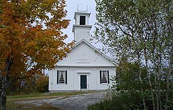
An early town minister, Reverend Benjamin Randall, founded a new religious denomination in 1780 called the Free Will Baptists, later known as Free Baptists. The church has two buildings in the community; the older built in 1819 on New Durham Ridge. [3]

Geography

According to the United States Census Bureau, the town has a total area of 43.8 square miles (113.5 km2), of which 41.2 square miles (106.7 km2) are land and 2.6 square miles (6.8 km2) are water, comprising 5.98% of the town. [1] The southern part of the town is drained by the headwaters of the Cocheco River and its tributary, the Ela River, and is part of the Piscataqua River watershed, flowing to the Atlantic Ocean at Portsmouth. The northern part of town is home to Merrymeeting Lake and its outlet, the Merrymeeting River, which flows west to Lake Winnipesaukee and is part of the Merrimack River watershed. The highest point in town (and in Strafford County) is 1,700 feet (520 m) above sea level, on the western slope of Copple Crown Mountain, along the town's eastern border. The mountain's 1,868-foot (569 m) summit is in the neighboring town of Brookfield, in Carroll County.

New Durham is served by New Hampshire Route 11.

Adjacent municipalities

Demographics

Historical population
CensusPop.Note
1790 554
1800 74233.9%
1810 88819.7%
1820 1,16831.5%
1830 1,162−0.5%
1840 1,032−11.2%
1850 1,0491.6%
1860 1,17311.8%
1870 973−17.1%
1880 772−20.7%
1890 579−25.0%
1900 6257.9%
1910 523−16.3%
1920 462−11.7%
1930 448−3.0%
1940 433−3.3%
1950 4636.9%
1960 4742.4%
1970 58323.0%
1980 1,183102.9%
1990 1,97466.9%
2000 2,22012.5%
2010 2,63818.8%
2020 2,6932.1%
U.S. Decennial Census [5]

As of the census [6] of 2000, there were 2,220 people, 819 households, and 630 families residing in the town. The population density was 53.2 inhabitants per square mile (20.5/km2). There were 1,309 housing units at an average density of 31.4 per square mile (12.1/km2). The racial makeup of the town was 98.15% White, 0.23% African American, 0.18% Native American, 0.54% Asian, 0.27% from other races, and 0.63% from two or more races. Hispanic or Latino of any race were 0.41% of the population.

There were 819 households, out of which 36.1% had children under the age of 18 living with them, 67.2% were married couples living together, 4.9% had a female householder with no husband present, and 23.0% were non-families. 17.0% of all households were made up of individuals, and 5.6% had someone living alone who was 65 years of age or older. The average household size was 2.71 and the average family size was 3.05.

In the town, the population was spread out, with 27.3% under the age of 18, 4.3% from 18 to 24, 32.8% from 25 to 44, 24.9% from 45 to 64, and 10.7% who were 65 years of age or older. The median age was 38 years. For every 100 females, there were 107.7 males. For every 100 females age 18 and over, there were 106.5 males.

The median income for a household in the town was $52,270, and the median income for a family was $52,941. Males had a median income of $35,574 versus $28,092 for females. The per capita income for the town was $22,139. About 3.7% of families and 5.1% of the population were below the poverty line, including 5.9% of those under age 18 and 6.6% of those age 65 or over.

Notable people

See also

Related Research Articles

<span class="mw-page-title-main">Strafford County, New Hampshire</span> County in New Hampshire, United States

Strafford County is a county in the U.S. state of New Hampshire. As of the 2020 census, the population was 130,889. Its county seat is Dover. Strafford County was one of the five original counties identified for New Hampshire in 1769. It was named after William Wentworth, 2nd Earl of Strafford in the mistaken belief that he was the ancestor of governor John Wentworth – although they were distantly related, William had no descendants. The county was organized at Dover in 1771. In 1840, the size of the original county was reduced with the creation of Belknap County.

<span class="mw-page-title-main">Bowdoinham, Maine</span> Town in the state of Maine, United States

Bowdoinham is a town in Sagadahoc County, Maine, United States. Bowdoinham was included in the Lewiston-Auburn, Maine metropolitan New England city and town area. The population was 3,047 at the 2020 census. It is part of the Portland–South Portland–Biddeford, Maine metropolitan statistical area. The town is located on the west side of Merrymeeting Bay.

<span class="mw-page-title-main">Alton, New Hampshire</span> Town in New Hampshire, United States

Alton is a town in Belknap County, New Hampshire, United States. The population was 5,894 at the 2020 census, up from 5,250 at the 2010 census. It is home to Alton Bay State Forest and Mount Major State Forest.

<span class="mw-page-title-main">Barnstead, New Hampshire</span> Town in New Hampshire, United States

Barnstead is a town in Belknap County, New Hampshire, United States. The population was 4,915 at the 2020 census, up from 4,593 at the 2010 census. Home to the Suncook Lakes, Barnstead includes the villages of Center Barnstead, Barnstead Parade and South Barnstead.

<span class="mw-page-title-main">Brookfield, New Hampshire</span> Town in New Hampshire, United States

Brookfield is a town in Carroll County, New Hampshire, United States. The population was 755 at the 2020 census.

<span class="mw-page-title-main">Wakefield, New Hampshire</span> Town in New Hampshire, United States

Wakefield is a town in Carroll County, New Hampshire, United States. The population was 5,201 at the 2020 census. The town includes the villages of Wakefield Corner, East Wakefield, North Wakefield, Sanbornville, Union, Woodman and Province Lake. Wakefield Corner, popular with tourists, is a picturesque hilltop village of antique buildings. The state of Maine forms the eastern border of Wakefield.

<span class="mw-page-title-main">Marlow, New Hampshire</span> Town in New Hampshire, United States

Marlow is a town in Cheshire County, New Hampshire, United States. The population was 749 at the 2020 census. Marlow is home to Honey Brook State Forest.

<span class="mw-page-title-main">Dummer, New Hampshire</span> Town in New Hampshire, United States

Dummer is a town in Coös County, New Hampshire, United States. The population was 306 at the 2020 census. It is part of the Berlin, NH–VT micropolitan statistical area. Dummer is home to the Pontook Reservoir, popular with canoeists, kayakers and birdwatchers. In the western part of Dummer lies the village of Paris.

<span class="mw-page-title-main">Hebron, New Hampshire</span> Town in New Hampshire, United States

Hebron is a town in Grafton County, New Hampshire, United States. The population was 632 at the 2020 census. Settlements include the town center and the village of East Hebron.

<span class="mw-page-title-main">Greenfield, New Hampshire</span> Town in New Hampshire, United States

Greenfield is a town in Hillsborough County, New Hampshire, United States. The population was 1,716 at the 2020 census. Greenfield is home to the Crotched Mountain Rehabilitation Center, to Greenfield State Park, and to part of the Wapack Trail.

<span class="mw-page-title-main">Sutton, New Hampshire</span> Town in New Hampshire, United States

Sutton is a town in Merrimack County, New Hampshire, United States. The population was 1,978 at the 2020 census. Sutton includes the villages of Sutton Mills, North Sutton, South Sutton and East Sutton. North Sutton is home to Wadleigh State Park on Kezar Lake.

<span class="mw-page-title-main">Barrington, New Hampshire</span> Town in New Hampshire, United States

Barrington is a town in Strafford County, New Hampshire, United States. The population was 9,326 at the 2020 census, up from 8,576 at the 2010 census. The town is a woodland, farm and commuter town.

<span class="mw-page-title-main">Lee, New Hampshire</span> Town in New Hampshire, United States

Lee is a town in Strafford County, New Hampshire, United States. The population was 4,520 at the 2020 census. The town is a rural farm and bedroom community, being close to the University of New Hampshire.

<span class="mw-page-title-main">Madbury, New Hampshire</span> Town in New Hampshire, United States

Madbury is a town in Strafford County, New Hampshire, United States. The population was 1,918 at the 2020 census.

<span class="mw-page-title-main">Middleton, New Hampshire</span> Town in New Hampshire, United States

Middleton is a town in Strafford County, New Hampshire, United States. The population was 1,823 at the 2020 census.

<span class="mw-page-title-main">Milton, New Hampshire</span> Town in New Hampshire, United States

Milton is a town in Strafford County, New Hampshire, United States. The population was 4,482 at the 2020 census. A manufacturing, resort and residential town, Milton includes the village of Milton Mills. The primary village in town, where 593 people resided at the 2020 census, is defined as the Milton census-designated place (CDP), and is located along New Hampshire Route 125 and the Salmon Falls River, just north of Route 75.

<span class="mw-page-title-main">Strafford, New Hampshire</span> Town in New Hampshire, United States

Strafford is a town in Strafford County, New Hampshire, United States. The population was 4,230 at the 2020 census. The two main settlements in town are Center Strafford and Bow Lake Village.

<span class="mw-page-title-main">Durham (CDP), New Hampshire</span> Census-designated place in New Hampshire, United States

Durham is a census-designated place (CDP) and the main village in the town of Durham in Strafford County, New Hampshire, United States. The population of the CDP was 11,147 at the 2020 census, out of 15,490 in the entire town. The CDP is home to the University of New Hampshire.

<span class="mw-page-title-main">Farmington (CDP), New Hampshire</span> Census-designated place in New Hampshire, United States

Farmington is a census-designated place (CDP) and the main village in the town of Farmington, Strafford County, New Hampshire, United States. The population of the CDP was 3,824 at the 2020 census, out of 6,722 in the entire town.

<span class="mw-page-title-main">Farmington, New Hampshire</span> Town in New Hampshire, United States

Farmington is a town in Strafford County, New Hampshire, United States. The population was 6,722 at the 2020 census. Farmington is home to Blue Job State Forest, the Tebbetts Hill Reservation, and Baxter Lake.

References

  1. 1 2 "2021 U.S. Gazetteer Files – New Hampshire". United States Census Bureau. Retrieved January 5, 2022.
  2. "Census - Geography Profile: New Durham town, Strafford County, New Hampshire" . Retrieved December 24, 2021.
  3. 1 2 Coolidge, Austin J.; John B. Mansfield (1859). A History and Description of New England. Boston, Massachusetts: A.J. Coolidge. pp.  596–597. coolidge mansfield history description new england 1859.
  4. Report of the Directors of the Boston & Maine Railroad to the Stockholders, September 12, 1849
  5. "Census of Population and Housing". Census.gov. Retrieved June 4, 2016.
  6. "U.S. Census website". United States Census Bureau . Retrieved January 31, 2008.
  7. 'Wisconsin Blue Book 1901,' Biographical Sketch of Alfred Miles Jones, pg. 739